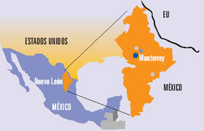
The northern state of Nuevo León is an industrial powerhouse, centered on Monterrey, Mexico’s third-largest city. The state’s shape on a map is unusual in more ways than one. The state has a long north-south axis and is very narrow from west to east. The strange indentation south of Monterrey is largely determined by relief. The peaks of the mountains on the Nuevo León side of that state boundary comprise a National Park, the Parque Nacional Cumbres de Monterrey.
Source: Universidad Autónoma de Nuevo León (UANL)
Perhaps the strangest aspect of the shape of Nuevo León is the peculiar extension that forms the state’s north-eastern extremity (see map above). This small section of the state, about 15 km across, is sandwiched between the states of Coahuila and Tamaulipas, and extends to the Río Bravo and the U.S. border. The reason for this particular extension must date back a long time since it is clearly shown on this 1824 map of Mexico.
(Note that the shape of the neighboring state of Tamaulipas, with its lengthy extension north-west paralleling the US border, made much more sense in the early nineteenth century before the current international boundary was established).
While we’re not sure of the precise timing or reasons for the “neck” of land that gave Nuevo León access to the Río Bravo even before the current international boundary was fixed, it has certainly brought the state some benefit in recent decades in terms of economics and trade. Nuevo León is the smallest of the combined ten “border states” in the USA and Mexico.
A closer look at the Google Map image (above) of this area shows the border crossing of Laredo-Colombia across the Solidarity International bridge. Colombia is the name of the small grid-pattern town on the Mexican side, just west of the crossing.
Zooming in on the area of the crossing reveals the distinctive street pattern of a major border crossing, with extensive parking and loading areas.
The 371-meter-long (1216 ft) bridge has eight lanes for traffic and two walkways for pedestrians. It is one of four vehicular international bridges close to the city of Laredo, Texas. The community of Colombia and the international bridge were built to give Nuevo León its only international “port” for direct trade to and from the USA.
Related posts:
Sorry, the comment form is closed at this time.