The preliminary results of Mexico’s 2010 population census reveal that the population residing in the Guadalajara Metropolitan Area (GMA) increased from 3.7 million in 2000 to 4.4 million in 2010. The census results also show clearly that the GMA is continuing to experience the effects of suburbanization and counter-urbanization.
Suburbanization is the gradual spread of the urban area into the surrounding rural areas. The built-up area of Guadalajara is spreading mainly to the south and west. The north-eastern part of the city is unable to spread beyond its existing extent because it is hemmed in by the precipitous canyon of the River Santiago, often referred to as La Barranca de los Oblatos (Oblates‘ Canyon).
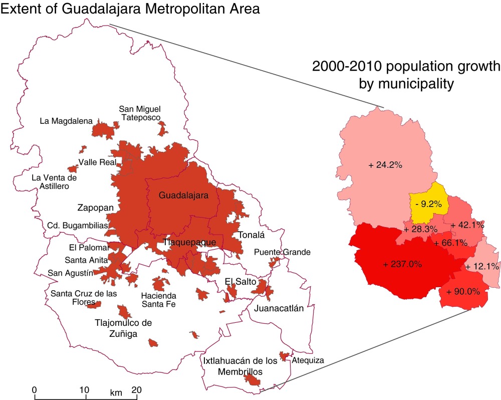
Counter-urbanization is the movement of city dwellers into smaller settlements in the surrounding countryside. With time, some of these smaller settlements are eventually engulfed by the spreading city. The precise boundaries of large metropolitan areas such as the GMA are therefore subject to almost constant change. The map below shows the population change for Guadalajara and its surrounding municipalities for the period 2000-2010.
Note, first, that the population of Guadalajara proper (the municipality of that name) has actually declined significantly since 2000, from 1,647,720 to 1,494,134.
The city is not bounded by the municipal boundary, but spreads into several adjoining municipalities (see map), all of which have experienced population growth between 2000 and 2010. The municipality of Tlaquepaque was already “built up”, even prior to 2000, and its population has risen only slowly since that date. The slowest rate of growth (excluding the “negative growth” of Guadalajara) is in Zapopan; this is a complete change from 30 years ago when Zapopan was growing very rapidly as Guadalajara expanded westwards.
In the 1980s and 1990s, Guadalajara also spread into Tonalá and El Salto. El Salto, relatively close to Guadalajara’s international airport, and close to the main Guadalajara-Mexico City highway, is the heart of a major industrial corridor. Its main focus in recent years has been on high-tech firms; the region is often referred to as “Mexico’s Silicon Valley”. Firms with manufacturing and/or assembly plants in or close to El Salto include Hewlett-Packard, IBM, General Electric, Intel, Hitachi, Siemens, Flextronics and Solectron. The El Salto area has seen moderate growth over the last ten years.
By far the most dramatic rates of growth for 2000-2010 occurred in Ixtlahuacán de los Membrillos. and in Tlajomulco de Zuñiga, which more than tripled its population in just ten years, from 123,220 to 416,552. Tlajomulco is a very old settlement indeed, with considerable historical importance. The spread of Guadalajara’s suburbs into the northern part of Tlajomulco has been astonishingly rapid, and represents a classic case of the process of suburbanization. Meanwhile, the population of the long-established settlement of Tlajomulco (further south in the eponymous municipality) has also risen rapidly as some urban dwellers choose, in the process of counter-urbanization, to live slightly outside the main urban sprawl of Guadalajara. The counter-urban movement is strongest in the settlements relatively close to the city, but now extends at least 50 km to the south, to the villages on the northern shore of Lake Chapala.
What will 2010-2020 bring? There are few signs that the building boom along the southern edge of Guadalajara Metropolitan Area is going to come to a halt any time soon. The state of Jalisco plans to construct an “outer ring road” south of the city. The planned route passes very close to the settlement of Tlajomulco. It is surely only a question of time before Tlajomulco, and various other small towns and villages, are swallowed up by the continuing expansion of Mexico’s second largest city.

Sorry, the comment form is closed at this time.