Climatologists have developed several scientific systems to classify climates. The system developed by Wladimir Köppen in the early 20th century is one of the earliest and best known. The Köppen climate classification system assumes that climate is best reflected in native vegetation and can be accurately classified using seasonal variations in temperatures and precipitation. Mexican climatologists, including Enriqueta García, have proposed minor modifications to the Köppen system to make it more appropriate for Mexico. The following paragraphs reflect García’s revised Köppen system.
Given that Mexico has many mountains with rapid changes in elevation, temperature and rainfall, applying the Köppen system, even as modified by García, to Mexico can become extremely complicated. A relatively small area of Mexico may include several Köppen climate categories. Aggregating these areas provides a less complicated, more understandable, picture of Mexico’s climates (see map). In this scheme, Mexico has seven main climate regions, as shown on the map:
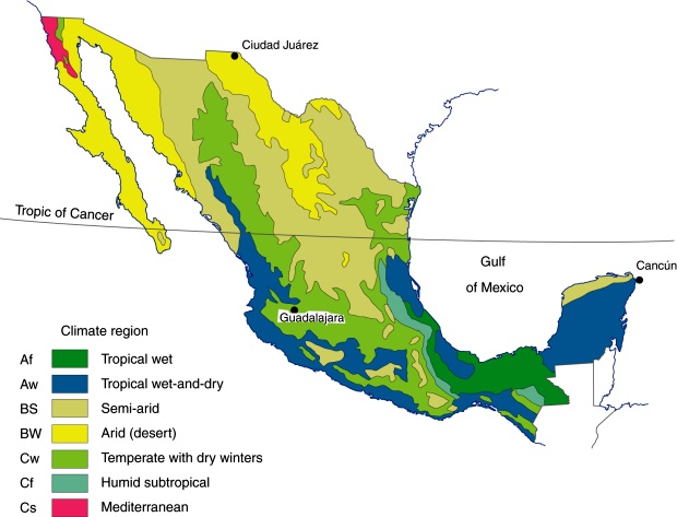
Major climate regions in Mexico. (Fig 4-5 of Geo-Mexico, the geography and dynamics of modern Mexico). All rights reserved.
Two tropical climates
Mexico has two tropical climates which have average temperatures of over 18°C (64°F) for all twelve months of the year.
The first, tropical wet (Af in the Köppen system, see map), has at least 60 mm (2.4 in) of rain in every month of the year. This is the climate of the Amazon and Indonesian rainforests. In Mexico this is the climate of the Gulf Coast Plain in southern Veracruz and Tabasco (classic tierra caliente areas). It also occurs in the Oaxaca and Chiapas highlands. The rains fall all year, varying from about 120–150 mm (4–5 in) in April to 380 mm (15 in) in September.
The tropical wet-and-dry (Aw) category (see the climate graph for Cancún) has a pronounced dry season. The dry winter months typically get less than 40 mm (1 in) of rain, compared to over 150 mm (6 in) in each of the summer months. Parts of West Africa, Brazil and India have a similar climate. Much of coastal Mexico, stretching from Nayarit along the Pacific coast all the way to Guatemala, is in this category. It also covers many inland areas along the Pacific coast. Central and northern Veracruz and most of the Yucatán Peninsula also have this tropical climate with summer rains.
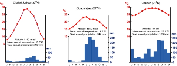
Climate graphs for three cities. (Fig 4.6 of Geo-Mexico, the geography and dynamics of modern Mexico) All rights reserved.
Two dry climates
Areas with an arid (desert) climate (BW) usually receive less than 250 mm (10 in) of rain a year (see climate graph for Ciudad Juárez). This is the climate of the Sahara Desert and Central Australia. In Mexico dry desert areas include most of Baja California, western Sonora, and the northern section of the Central Plateau. These areas can experience frost and freezing during the winter.
Areas with the second type of arid climate, semiarid (dry steppe) (BS), receive 250–750 mm (10–30 in) of rain a year. This is the climate of the African savanna lands and much of central Asia. In Mexico, this climate region includes most of the Central Plateau as well as western sections of the Western Sierra Madre, northern Yucatán and scattered inland areas as far south as Oaxaca. The rains in this region fall mostly in the summer, and localized heavy thunderstorms are quite common. The southern parts of this climatic region are warmer than the northern parts.
Three temperate zones
Temperate climates typically have average temperatures above 10°C (50°F) in their warmest months, and a coldest month average between 3°C and 18°C (27–64°F). Moisture characteristics distinguish between the three temperate climates.
The temperate with dry winters climate (Cw) is characterized by mild temperatures, low humidity, and summer rainfall ranging from about 600 to 1200 mm (25–45 in) per year (see climate graph for Guadalajara). This is classic tierra templada country. The low nighttime temperatures in winter are typically around 5°C (41°F). Of course, higher elevations have lower temperatures with occasional frost. The highest temperatures usually reach about 35°C (95°F), though temperatures may reach as high as 40°C (104°F). This climate is similar to that of the Kenyan Highlands. In Mexico, this climate includes parts of Nuevo León and Tamaulipas, most of the Western Sierra Madre and many mountainous areas in western, central and southern Mexico. Most of the Volcanic Axis is in this temperate with dry winters zone. Here, the major control as far as temperatures are concerned is altitude, which directly affects precise rainfall amounts and seasonality, resulting in a mosaic of microclimates and natural vegetation regions.
Compared with the temperate with dry winters climate, the humid subtropical (Cf) zone gets more rainfall, is more humid and gets rain throughout the year. The only areas of Mexico with this climate are the eastern slopes of the Eastern Sierra Madre and some parts of the southern mountain systems.
The Mediterranean climate (Cs) is the mild climate associated with Europe’s Mediterranean coast as well as the California coast. The area around Tijuana is the only part of Mexico with this type of climate. This area is relatively arid and gets less than 400 mm (15 in) of rain a year; it is unique in Mexico, being the only place that is dry in summer and gets rain only in winter.
Related posts
Sorry, the comment form is closed at this time.