Dec 172016
 

Most of Mexico is above 1000 m (about 3300 ft) in elevation; as a result most of Mexico has a more temperate climate than might be expected given its latitude.

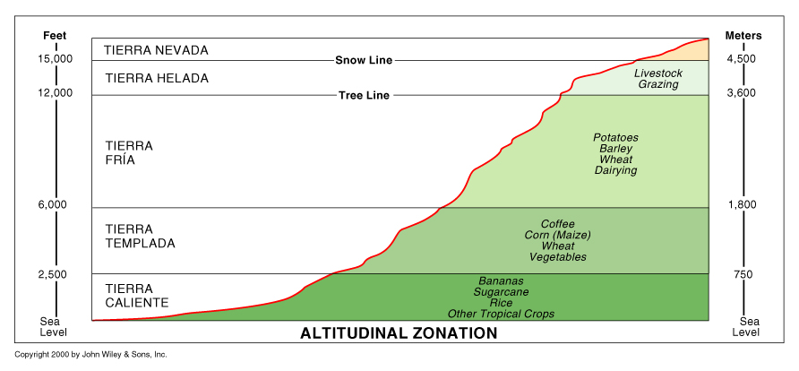
The famous explorer Alexander von Humboldt, one of the founding fathers of physical geography and meteorology, was the first to describe the vertical differentiation of climatic and vegetation zones in Mexico. Writing in 1811, he proposed the terms tierra caliente, tierra templada, and tierra fría, still widely used by non-specialists today.

Tierra caliente (hot land) includes all areas under about 900 m (3000 ft). These areas generally have a mean annual temperature above 25°C (77°F). Their natural vegetation is usually either tropical evergreen or tropical deciduous forest. Farms produce tropical crops such as sugar-cane, cacao and bananas.

Altitude zones

Altitude zones. Copyright John Wiley & Sons Inc. 2000.

Tierra templada (temperate land) is the area between 900 and 1800 m (3000 to 6000 ft) where mean annual temperatures are usually between about 18°C and 25°C (64°F to 77°F). The natural vegetation in these zones is temperate forest, such as oak and pine-oak forest. Farms grow crops such as corn (maize), beans, squash, wheat and coffee.

Tierra fria (cold land) is over 1800 m (6000 ft) where mean annual temperatures are in the range 13°–18°C (55°–64°F). At these altitudes pine and pine-fir forests are common. Farm crops include barley and potatoes. On the highest mountain tops, above the tierra fría is tierra helada, frosty land.

Even higher, and almost permanently under snow and ice, is the tierra nevada, snow-covered land.
A brief history of geography in Mexico

 Other  Comments Off on A brief history of geography in Mexico
Feb 192010
 

Mexico has a long tradition of geography. Modern geography was given a jump-start in the country by the brilliant Prussian traveler Alexander von Humboldt, who explored Mexico for twelve months in 1803–04.

The Mexican Society of Geography and Statistics was founded in 1833, only three years after the UK’s Royal Geographical Society and fully 55 years before the National Geographic Society. Geography remains a popular and respected subject in Mexican high schools and universities.

Even prior to Humboldt, many authors had made valuable descriptions of many aspects of Mexico’s geography. Writing in the mid-17th century, but looking back to a century earlier, Father Antonio Tello, in describing the province of Xalisco (Jalisco) offers lots of information about plants, animals, natural hazards, rivers and natural hot springs, while speculating about whether underwater springs fed Lake Chapala, Mexico’s largest natural lake.

Though many volumes have been lost, the surviving parts of the Geographic Accounts written at the end of the 16th century are a veritable “Domesday Book” of information.

After Humboldt, however, geography set off on a much more scientific, analytical path, one which has continued to the present day and which has now resulted in Richard Rhoda and Tony Burton’s Geo-Mexico: the geography and dynamics of modern Mexico.