Colima Volcano (aka the Volcán de Fuego) is one of the westernmost volcanoes in Mexico’s Volcanic Axis, which straddles the country from west to east. The Volcano’s summit is only 8 km (5 miles) from the inactive Nevado of Colima volcano, Mexico’s sixth-highest peak, which rises 4260 m (13,976 ft) above sea level. (Curiously, despite their names, the summits of both volcanoes are actually located in the state of Jalisco and not the state of Colima.)
The elevation of Colima Volcano is officially given as 3820 m (12,533 ft) above sea level. In the past 400 years, it has been the most active volcano in Mexico, having erupted at least 30 times since 1576.
It is also considered to be one of the country’s most dangerous volcanoes. Numerous villages in its shadow keep a wary eye on its level of activity, and emergency evacuations have become a regular event in the past fifty years.
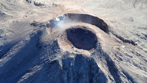
Colima Volcano forms new crater, 11 Jan 2013. Photo: Edo de Jalisco Protección Civil.
On a geological time-scale, the volcano first erupted about five million years ago in the Pliocene period, long after activity ceased at the nearby, and higher, Nevado de Colima. It quickly developed into a large volcano which partially blew apart or collapsed during Pleistocene times to form a caldera, five kilometers across. A new cone developed inside the caldera. This is the Volcán de Fuego we see today.
The cone is built mainly of pyroclastic materials (ashes and volcanic bombs) of andesitic composition together with some basaltic lava, making it a classic example of a composite volcanic cone.
Historically, the eruptions of the volcano have fallen into a definite cyclical pattern with periods of activity, each lasting about 50 years, interspersed with periods of dormancy. The first cycle of activity (after the Spanish arrived in Mexico) was between 1576 and 1611. Major eruptions occurred in 1680 and 1690, and further complete cycles occurred between 1749 and 1818, and from 1869 to 1913. Most geologists agree that current activity is part of the fifth cycle, which began in 1961.
A three year sequence of prior activity (2003 to 2005) is shown on this series of NASA satellite images.
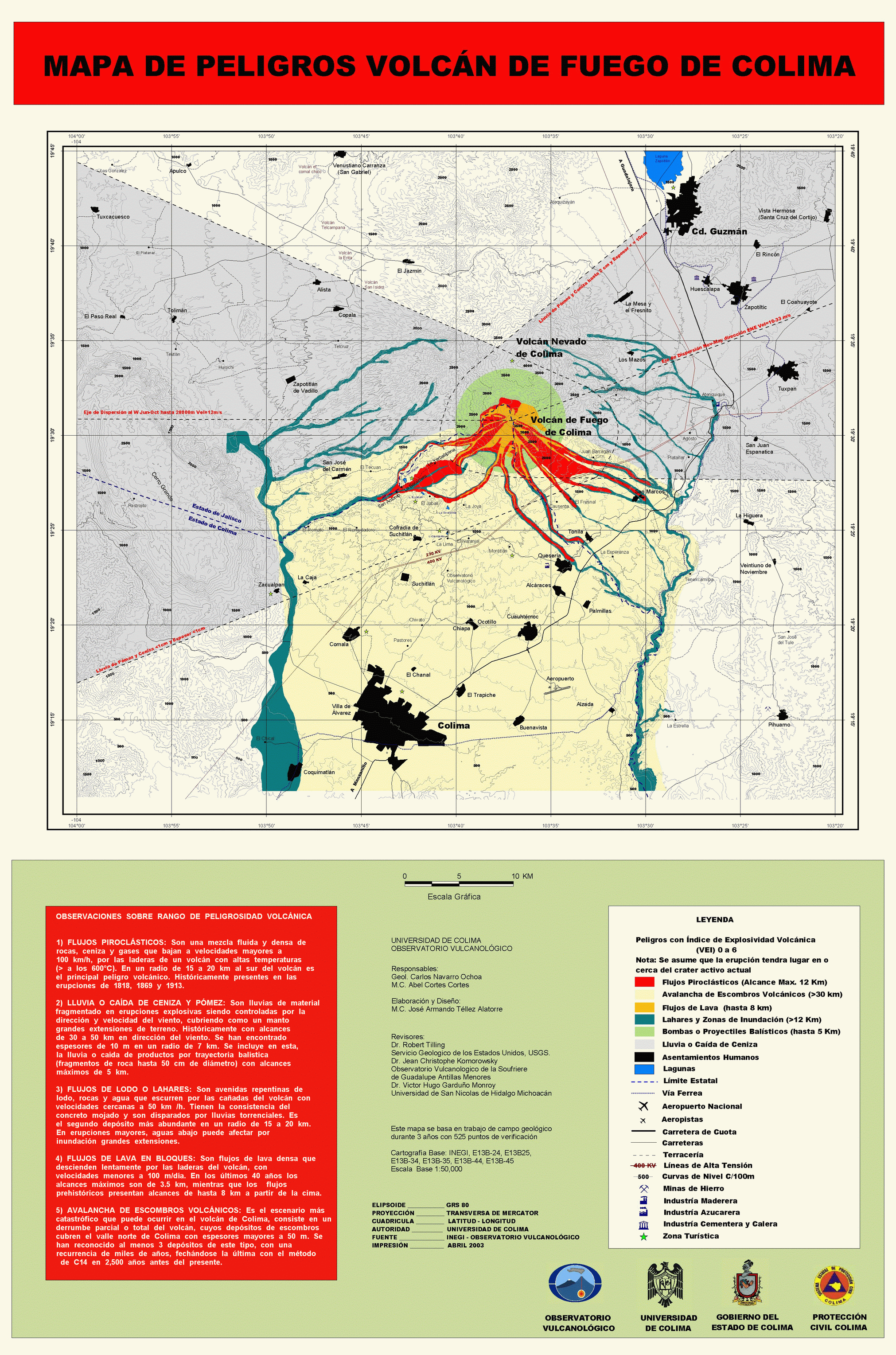
Hazard Map of Colima Volcano (2003) Credit: Universidad de Colima, Observatorio Vulcanológico. Click for full-size image (large file size)
In each major cycle, the first results of renewed activity force new lava into the existing crater, forming a dome. Once the crater has filled up, any additional lava is ejected from the crater and flows down the volcano’s flanks. If the lava is unable to escape (relieving the underground pressure), the dome is liable to explode, which is exactly what happened a few days ago:
- Reportan destrucción del domo del Volcán de Colima (Spanish language news report)
- Spanish language TV report
As on several previous occasions, once the subterranean pressure that caused the activity has been relieved, activity should cease, and the volcano will enter another less dangerous dormant phase. Even during this phase, a plume of hot gas often billows out from the volcano.
The dome that was destroyed in January 2013 began to build in 2007. The explosive activity on 6 January and 10 January 2013 left behind a new crater 220 meters (720 ft) across and about 50 m (165 ft) deep. According to the Jalisco-Colima Scientific Committee (which oversees the hazard analysis posed by the volcano), the events of 6 and 10 January emitted an estimated 1.5 million cubic meters of material, which formerly formed the dome. The 10 January explosion, which occurred at 21:40 hrs local time, sent incandescent material down the west flank of the volcano. An ash column rose about 3000 meters into the air before traveling north-eastwards on the wind towards the city of Ciudad Guzmán.
Thermal imaging shortly after the 10 January explosion showed that the temperatures in the crater are below 200 degrees Centigrade, which indicates relatively little gaseous build up and limited risk of further major explosions. Even so, a prudent 7.5 km exclusion zone is being maintained around the volcano.
Update (29 Jan 2013):
Another explosion at 3:58 am on 29 January 2013 created a plume of ash and cinders that rose more than 3000 meters above the volcano. The ash fell of nearby villages, including Los Mazos, Ejido Atenquique, Tuxpan and Huescalapa.
The area around the volcanoes is described in more detail in chapter 15 of “Western Mexico, a Traveler’s Treasury” (4th edition; Sombrero Books, 2013).
Related posts:
- Mexico’s highest volcanoes
- Alert level rises as Popocatepetl volcano starts to erupt (April 2012)
- Update on the activity of Popocatepetl Volcano (May 2012)
- The story of Paricutín volcano in Michoacán
- Mexico’s geomorphosites: the volcanic spine of Tequila Volcano, Jalisco
- The eruption of El Chichón volcano in 1982
- How has the movement of tectonic plates affected Mexico?
Sorry, the comment form is closed at this time.