In a previous post, we described the considerable geotourism potential of the Primavera Forest near Guadalajara:
In this post, we take a closer look at how this unusual area was formed.
Stages 1 and 2 (see diagram):
140,000 BP. The magma chamber beneath the surface began to fill with magma (molten rock underground) and grow in size.
By about 120,000 BP, several lava flows and domes had formed, made primarily of rhyolite, a silica-rich (“acid”) igneous rock. After each eruption, the magma level underground would subside for a period of time before pressure built up again towards the next eruption.
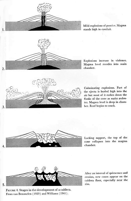
Fig. 4 of Bullard (1962) “Volcanoes in history, in theory, in eruption”. Based on van Bemmelen (1929) and Williams (1941)
Stages 3 and 4
So much pressure had built up by about 95,000 BP that there was a huge explosion, sending 20 cubic kilometers (4.8 cubic miles) of rock and ashes high into the sky. The explosion covered 700 square kilometers (270 square miles) with volcanic materials, known today as the Tala tuff (tuff is the geological term for consolidated ash). This massive explosion caused the upper part of the magma chamber to collapse, leaving a caldera that was 11 kilometers (6.8 miles) wide. The Tala tuff includes large quantities of pumice, a light and porous volcanic rock formed when a gas-rich froth of glassy lava solidifies rapidly.
This caldera filled with water, creating a lake.
Stage 5
This stage began shortly afterwards when a series of ring domes were erupted around the edge of the caldera as the magma deep below the surface started to push upwards again, eventually forming small islands in the lake. These eruptions formed more pumice, blocks of which would break off and start to float across the lake as they gradually sank to the lake floor.
A further series of eruptions in about 75,000 BP led to a second series of ring domes. A combination of tectonic uplift and sedimentation had filled the lake in by about this time.
More volcanic domes have been created at approximately 30,000 year intervals since, in about 60,000 BP and about 30,000 BP; these domes were almost all on the southern and eastern margins of the caldera, and include the lava domes of El Colli and El Tajo on the outskirts of Guadalajara.
Many geologists appear quietly confident that lava and ash eruptions in La Primavera are a thing of the past. They consider that the Primavera Forest’s fumaroles, hot river and hot waterfall represent the last vestiges of vulcanism and are no cause for alarm. On the other hand, others, including Gail Mahood who has studied this area far more than most, warn that hazard monitoring is justified in the case of La Primavera given its proximity to a major city and bearing in mind that any future eruption would be likely to occur on the southern and/or eastern side of the caldera.
The La Primavera Forest is only one of several calderas in Mexico’s Volcanic Axis.
If you prefer a short 9 minute video animation of how the area was formed, try this excellent YouTube video: “The Exciting Geology of Bosque La Primavera“, produced by geologist Barbara Dye during her stint as a Peace Corps volunteer in Mexico.
References:
- Mahood G. A. 1980. Geological evolution of a Pleistocene rhyolitic center – Sierra La Primavera, Jalisco, Mexico. Journal of Volcanology and Geothermal Research, 8: 199-230.
- Mahood, G.A. 1981. A summary of the geology and petrology of the Sierra La Primavera, Jalisco, Mexico. Journal of Geophysical Research, Volume 86.
- Dye, Barbara. 2013. “La Apasionante Geología del Área de Protección de Flora y Fauna La Primavera”.
Related posts:
- Paricutin Volcano in Mexico celebrates its 70th birthday
- Mexico’s highest volcanoes
- Mexico’s geomorphosites: the volcanic spine of Tequila Volcano, Jalisco
- How has the movement of tectonic plates affected Mexico?
- Mexico’s Volcanic Axis
- The world’s smallest volcano is in Puebla, Mexico
Sorry, the comment form is closed at this time.