The geography of tequila: where is tequila made?

 Other  Comments Off on The geography of tequila: where is tequila made?
Nov 142016
 

The production of (genuine) tequila is tightly regulated because tequila has denomination of origin status. This status (sometimes called appellation of origin) sets specific standards for producers in terms of how a product is grown or produced, processed and presented. Equally importantly, it defines the geographic indication, the specific places or regions where the product has to be made. Other items having denomination of origin status include champagne, asiago cheese and Melton Mowbray pork pies.

Geographic indications are “indications which identify a good as originating in the territory of a Member, or a region or locality in that territory, where a given quality, reputation or other characteristic of the good is essentially attributable to its geographic origin.” (World Trade Organization)

Mexico’s denomination of origin area for genuine tequila includes includes 180 municipalities in five states, a total area of about 11 million hectares (27 million acres).
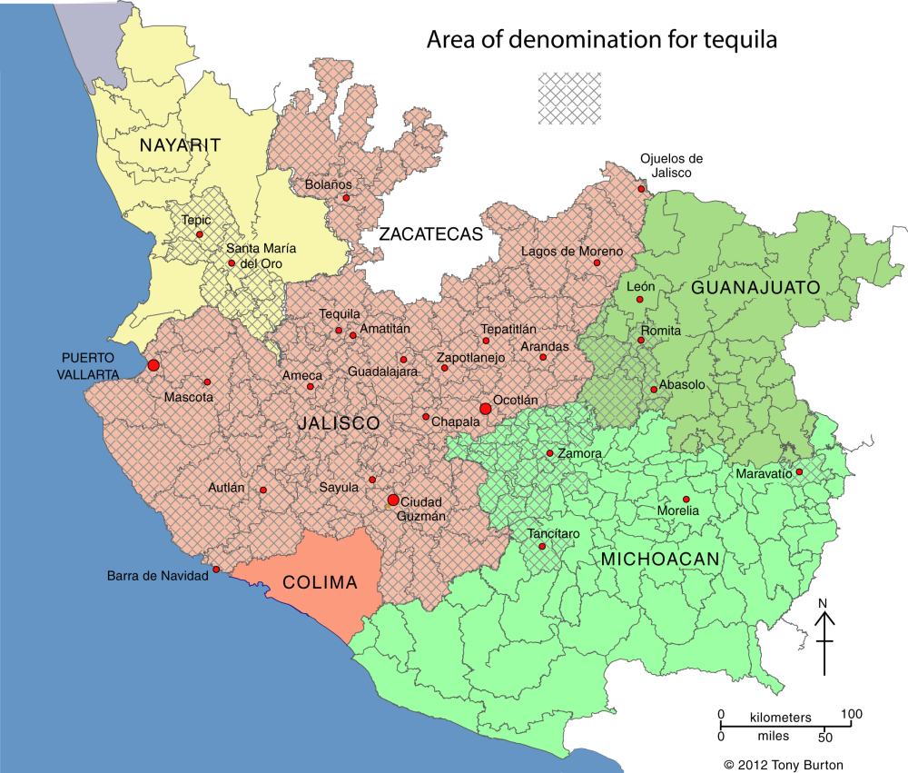
Tequila producing areas of Jalisco and neighboring states.

Tequila producing areas of Jalisco and neighboring states. Credit: Tony Burton; all rights reserved. Click to enlarge

The main area (see map above) is the state of Jalisco (all 124 municipalities), with extensions into three neighboring states:

  • Nayarit (8 municipalities): Ahuacatlán, Amatlán de Cañas, Ixtlán del Río, Jala, Xalisco, San Pedro Lagunillas, Santa María del Oro and Tepic.
  • Guanajuato (7 municipalities): Abasolo, Cd. Manuel Doblado, Cuerámaro, Huanimaro, Pénjamo, Purísima del Rincón and Romita.
  • Michoacán (30 municipalities): Briseñas de Matamoros, Chavinda, Chilchota, Churintzio, Cotija, Ecuandureo, Jacona, Jiquilpan, Maravatío, Marcos Castellanos, Nuevo Parangaricutiro, Numarán, Pajacuarán, Peribán, La Piedad, Régules, Los Reyes, Sahuayo, Tancítaro, Tangamandapio, Tangancicuaro, Tanhuato, Tinguindín, Tocumbo, Venustiano Carranza, Villa Mar, Vista Hermosa, Yurécuaro, Zamora, and Zináparo.
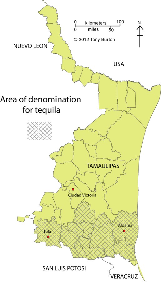
Tequila growing area in Tamaulipas.

Tequila growing area in Tamaulipas. Credit: Tony Burton; all rights reserved. Click to enlarge.

About 80% of all blue agave is grown in Jalisco, and almost all tequila distilleries are located in the state.

The municipality of Maravatío in the eastern section of Michoacán is a tequila outlier, some distance away from the main producing area centered on Jalisco.

The other major outlier is a group of 11 municipalities in the northern border state of Tamaulipas (see second map) where 11 municipalities (Aldama, Altamira, Antiguo Morelos, Gómez Farías, González, Llera, Mante, Nuevo Morelos, Ocampo, Tula and Xicotencatl) are included in the denomination of origin for tequila.

The first denomination of origin for tequila was registered with the World Intellectual Property Organization in 1978. Since that time every trade agreement signed by Mexico has contained a clause to ensure that tequila’s special status is fully protected by the other signatories. Mexico has signed free trade agreements with more countries than any other country in the world.

For example, the relevant NAFTA clause states that:

“Canada and the United States shall recognize Tequila and Mezcal as distinctive products of Mexico. Accordingly, Canada and the United States shall not permit the sale of any product as Tequila or Mezcal, unless it has been manufactured in Mexico in accordance with the laws and regulations of Mexico governing the manufacture of Tequila and Mezcal.”

In 1996, Mexico succeeded in getting the World Trade Organization to recognize tequila, and also mezcal, as denomination of origin products.

The following year, Mexico signed an agreement with the European Union whereby Mexico recognized 175 European spirits, including champagne, cognac, grappa and scotch, as having denomination of origin protection, in exchange for E.U. protection for tequila and mezcal. At that time, Mexico’s Tequila Regulatory Council (CRT) estimated that some 3.5 million liters of “pseudo-tequilas” were sold annually in Europe under such names as “Blue Tarantula” in Italy and “Hot Tequila” in Finland (In search of the blue agave: Tequla’s denomination of origin).

Related posts:

Nov 072016
 

In a previous post – Mexico’s shoe (footwear) manufacturing industry: regional clustering – we looked at the concentration of the shoe-manufacturing industry in three major areas: León (Guanajuato), Guadalajara (Jalisco) and in/around Mexico City. We have also taken a look at Mexico’s international trade in shoes – Mexico’s footwear industry: imports and exports. We now turn our attention to the distribution of shoe retailers within a large Mexican city.

Shoes in Mexico

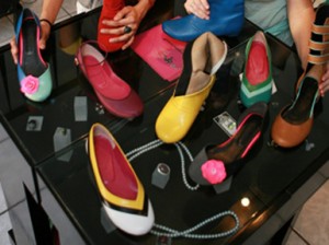
The retailing of shoes within cities often exhibits distinctive spatial patterns. Many older and larger Mexican cities tend to have all the retailers for a particular item (furniture, electronics, autoparts, etc) concentrated in a very small area. For example, dozens of retail outlets for electronics are located within a few blocks of Mexico City’s main square or zócalo. Electronics stores are in very close proximity to one other, and occupy both sides of the street for several blocks, leaving little or no room for any other retailers.

Another example of retail specialization is Corregidora street, which has several blocks dedicated to the sale of pots and pans, kitchen utensils and table settings.

Elsewhere in Mexico City’s downtown area:

… turn right and continue down Chile street to the intersection with Tacuba street. One of the most fascinating aspects of commercial life in the downtown area of Mexico City is that each area is specialized in some trade or retail activity. Such trading ghettos were also a feature in Tenochtitlán and the practice still exists today. Where you are now walking is the barrio of bridal shops. The greatest concentration of these shops is north of the Heras y Soto House…” (Candace Siegle, Walking through History, a series of walks through Mexico City’s historic center, 1989)

Returning to the subject of shoes, without which no bridal outfit is complete, shoe retailing is also often heavily concentrated in certain sections of Mexico’s larger cities. Perhaps the most extreme example is in Guadalajara, where shoe retailing is concentrated in two main zones. One of these zones is within the central business district, and is comprised of both regular storefronts and a market. The other area is several kilometers west of the center, around Galería del Calzado, a shopping plaza of more than 60 stores entirely dedicated to shoes. The Galería, located where Yaquis meets Avenida México, has a total floor space in excess of 8,600 square meters (92,500 square ft). The shops in Galería del Calzado stock every major brand and type of shoe, and eagerly compete for your pesos.

From a consumer’s perspective, this is all highly convenient and allows for easy comparison shopping. However, I have never been convinced of the advantages of such concentration from the point of view of the retail store owners, unless perhaps they get their stock from a relatively limited number of (shared) shoe distributors?

Despite the success of many Mexican shoe manufacturers, one of the fundamental weaknesses of the supply chain for footwear in Mexico (according to sector analysts) is the absence of any strong specialized marketer dedicated to shoes. Fancy a job marketing cowboy boots, anyone?

Related posts:

Chapters 21 and 22 of Geo-Mexico: the geography and dynamics of modern Mexico analyze Mexico’s 500-year transition to an urban society and the internal geography of Mexico’s cities. Chapter 23 looks at urban issues, problems and trends. Buy your copy of this invaluable reference guide today!

Nov 012016
 

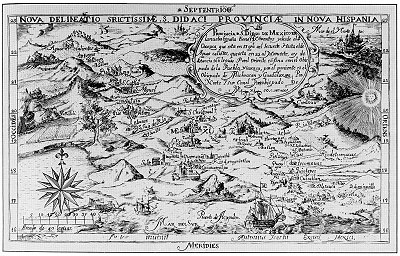
One of the earliest known maps engraved in colonial New Spain (Mexico) was that drawn by Antonio Ysarti in 1682. It shows the Franciscan Province of  San Diego of Mexico, with its 14 friaries, from Oaxaca in the southeast to Aguascalientes in the northwest. It covers the archdiocese of Mexico City, as well as the dioceses of  Puebla and Oaxaca to the east, and Michoacán and Guadalajara to the west.

Ysarti's 1682 map of New Spain

Ysarti’s 1682 map of New Spain; click map for an enlarged version of Mexico City to Acapulco

The beautifully-drawn map was originally published to illustrate Baltasar de Medina’s 1682 Chronica de la Santa Provincia de San Diego de Mexico, printed by Juan de Ribero. In the words of the sellers of this map’s original copper plate to the Library of Congress, “This artifact is tangible evidence of an emerging scientific and artistic community in a growing colonial empire.”

Sadly, very little is known about Antonio Ysarti, the map’s talented cartographer; not even his nationality is known for certain.

The map measures 29 x 19 cm approx (11.25 x 7.25 inches) and names more than 50 places. Each friary is depicted as an architecturally distinct building, not by the use of a common symbol.

Q. How well do you know central Mexico? Click on the map above (to reveal the section between Mexico City and Acapulco) and then see how many places you can identify and match to present-day place names.

Online version of this map, offering the ability to zoom in to specific parts

The changing political frontiers of Mexico are the subject of chapter 12 of Geo-Mexico: the geography and dynamics of modern Mexico, a handy reference guide to all aspects of Mexico’s geography. If you have enjoyed this post, please consider gifting a copy of Geo-Mexico to someone in the coming holiday season.