Nov 072016
 

In a previous post – Mexico’s shoe (footwear) manufacturing industry: regional clustering – we looked at the concentration of the shoe-manufacturing industry in three major areas: León (Guanajuato), Guadalajara (Jalisco) and in/around Mexico City. We have also taken a look at Mexico’s international trade in shoes – Mexico’s footwear industry: imports and exports. We now turn our attention to the distribution of shoe retailers within a large Mexican city.

Shoes in Mexico

The retailing of shoes within cities often exhibits distinctive spatial patterns. Many older and larger Mexican cities tend to have all the retailers for a particular item (furniture, electronics, autoparts, etc) concentrated in a very small area. For example, dozens of retail outlets for electronics are located within a few blocks of Mexico City’s main square or zócalo. Electronics stores are in very close proximity to one other, and occupy both sides of the street for several blocks, leaving little or no room for any other retailers.

Another example of retail specialization is Corregidora street, which has several blocks dedicated to the sale of pots and pans, kitchen utensils and table settings.

Elsewhere in Mexico City’s downtown area:

… turn right and continue down Chile street to the intersection with Tacuba street. One of the most fascinating aspects of commercial life in the downtown area of Mexico City is that each area is specialized in some trade or retail activity. Such trading ghettos were also a feature in Tenochtitlán and the practice still exists today. Where you are now walking is the barrio of bridal shops. The greatest concentration of these shops is north of the Heras y Soto House…” (Candace Siegle, Walking through History, a series of walks through Mexico City’s historic center, 1989)

Returning to the subject of shoes, without which no bridal outfit is complete, shoe retailing is also often heavily concentrated in certain sections of Mexico’s larger cities. Perhaps the most extreme example is in Guadalajara, where shoe retailing is concentrated in two main zones. One of these zones is within the central business district, and is comprised of both regular storefronts and a market. The other area is several kilometers west of the center, around Galería del Calzado, a shopping plaza of more than 60 stores entirely dedicated to shoes. The Galería, located where Yaquis meets Avenida México, has a total floor space in excess of 8,600 square meters (92,500 square ft). The shops in Galería del Calzado stock every major brand and type of shoe, and eagerly compete for your pesos.

From a consumer’s perspective, this is all highly convenient and allows for easy comparison shopping. However, I have never been convinced of the advantages of such concentration from the point of view of the retail store owners, unless perhaps they get their stock from a relatively limited number of (shared) shoe distributors?

Despite the success of many Mexican shoe manufacturers, one of the fundamental weaknesses of the supply chain for footwear in Mexico (according to sector analysts) is the absence of any strong specialized marketer dedicated to shoes. Fancy a job marketing cowboy boots, anyone?

Related posts:

Chapters 21 and 22 of Geo-Mexico: the geography and dynamics of modern Mexico analyze Mexico’s 500-year transition to an urban society and the internal geography of Mexico’s cities. Chapter 23 looks at urban issues, problems and trends. Buy your copy of this invaluable reference guide today!

The spatial diffusion of Banamex branches across Mexico prior to 1960

 Other  Comments Off on The spatial diffusion of Banamex branches across Mexico prior to 1960
Jan 102015
 

This post looks at where branches of Banamex (Banco Nacional de México) were founded in the period prior to 1960. Banamex is one of the oldest banking institutions in Mexico. It is now a subsidiary of Citigroup, but remains the second largest bank in the country after BBVA Bancomer.

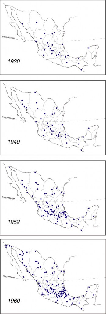
Diffusion of Banamex branches across Mexico prior to 1960

Diffusion of Banamex branches across Mexico prior to 1960. Click to enlarge

Banamex was formed on 2 June 1884 from the merger of Banco Nacional Mexicano and Banco Mercantil Mexicano, two banks that had only been operating for a couple of years. Shortly after its founding, Banamex had branches in Mexico City, Mérida, Veracruz, Puebla, Guanajuato, San Luis Potosí, and Guadalajara.

The maps to the left are based on Figure 8 of Las Regiones Geográficas en México by Claude Bataillon (8th edition, 1986, Siglo Veintiuno Editores).

Each dot represents the location of a branch of Banamex in the year shown. For simplicity’s sake, it is assumed that all branches present on any earlier map continued to exist through to 1960, and did not close or relocate in the interim.

The concept of spatial diffusion looks at the spread of an innovation, whether a new idea, technique, good, service or brand. The spatial diffusion of information or of the adoption of innovations is an important subset of spatial interactions. Looking at the spatial diffusion of a banking network offers lots of interesting insights into how Mexico’s economic geography has changed over the years.

There are three basic types of diffusion. The first is relocation diffusion where people travel or migrate and bring their cultural and technological practices with them. For example, modern studies in the genetics of corn (maize) have established that ancient Mexicans first domesticated corn in the Balsas valley. They then migrated both northwards and southwards, taking the practice of cultivating corn with them.

The second is contagious diffusion, which generally spreads from person to person and exhibits strong distance decay. An example is the spread of the Jehovah’s Witness faith in Mexico which required a considerable amount of face-to-face personal interaction. Many diseases also spread by contagious diffusion.

The third is hierarchical diffusion, which spreads across higher levels of a hierarchy and then down to lower levels. This is often how information from the top of an organization reaches those at the bottom. An example is the government’s 1970s family planning program that was first adopted in large cities, then smaller cities, and eventually penetrated into rural areas.

Combinations of these three types are also possible. One relatively recent example is the spread of the H1N1 influenza virus in early 2009. First reports were that it started in a rural village, probably in Oaxaca, and spread by contagious diffusion to others in the village. From there an infected person temporarily relocated to Mexico City where the flu again spread by contagious diffusion. From Mexico City, the top of the Mexican hierarchy, it spread down the hierarchy as carriers of the virus traveled to smaller Mexican cities and to other cities worldwide.

In the case of the diffusion of Banamex branches shown on the maps, the main type of diffusion involved is hierarchical. In this case, given that Banamex is a banking institution, the hierarchy reflects where most economic activity is taking place at the time. (There would be little point in placing a new branch in a location where little money was in circulation).

The 1930 distribution of Banamex branches looks to be quite scattered across the country, though Baja California and north-west Mexico have no branches and fall outside the network. By 1940 more additional branches have opened in the northern half of Mexico than the southern half, and the north-south economic divide that we have commented on in many previous posts is beginning to become apparent. Between 1940 and 1952 many new Banamex branches are added in central Mexico (this is the period when in-migration was turning Mexico City into a monster) and along the west coast, following the line of Highway 15 which runs from Guadalajara to the border with California. Overall, the north-south divide is now quite clear.

Between 1952 and 1960 additional branches open close to the US border, a branch finally reaches Baja California Sur (in La Paz) and the economic dominance of northern Mexico over southern Mexico is clearly established.

One of the most striking features, when comparing all four maps, is how the number of Banamex branches in southern and south-eastern Mexico (defined as the states of Chiapas, Tabasco, Campeche, Yucatán and Quintana Roo) barely changed between 1930 and 1960.

It would be interesting to update this example with similar maps for more recent years. Please contact us if you have access to suitable data or know where such data may be found.

Other posts related to the concept of diffusion:

Another instance of diffusion, of cholera in Mexico during the 1991-1996 epidemic, is mapped and discussed in chapter 18 of Geo-Mexico: the geography and dynamics of modern Mexico. Geo-Mexico also includes an analysis of the pattern of HIV-AIDS in Mexico, and of the significance of diabetes in Mexico.

Shopping habits in Mexico

 Mexico's geography in the Press  Comments Off on Shopping habits in Mexico
Aug 282013
 

Kantar Worldpanel México’s survey of shopping habits for 8,500 homes across the country reveals that 70% of household expenditures are spent in one of three main “purchasing channels”.

1. The first, traditional convenience or “corner” stores receive 35% of household spending, and are the channel most frequently visited, 217 times/year/household on average. Poorer households rely more on these stores than middle-class households. Most visits (71%) are on weekdays and 44% of visits are to purchase items for immediate consumption.

2. Supermarkets are the second main channel, used by 98% of households, with a frequency of 49 trips/year. Supermarkets are favored by middle class families for their weekly or biweekly shop, usually on weekends.

3. The third main channel is door-to-door and catalog sales, used by 92% of households, with a frequency of 42 times/year.

According to the study, 74% of households choose the nearest store and 78% attach importance to the location of the store.

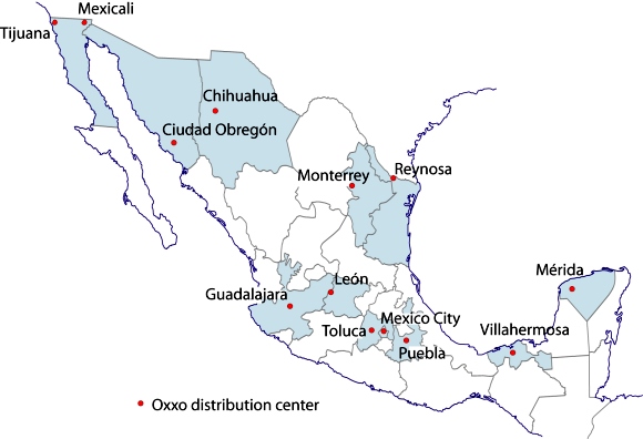
Cities with Oxxo Distribution Centers. Credit: Tony Burton/Geo-Mexico

Cities with Oxxo Distribution Centers. Credit: Tony Burton/Geo-Mexico

It is no coincidence, then, that Oxxo, the nation’s largest convenience store chain, recently opened its 11,000th store in Mexico. Oxxo now serves residents of 350 towns and cities, and plans to add a further 1,037 outlets before the end of this year. Its extensive network is served via a chain of 15 strategically-located distribution centers in the 13 cities shown on the map above.

Related posts:

The origins of street markets (tianguis) in Oaxaca, Mexico

 Other  Comments Off on The origins of street markets (tianguis) in Oaxaca, Mexico
Oct 152012
 

In an earlier post, we looked at the benefits brought by Mexico’s street markets (tianguis) to both vendors and consumers, and mentioned their long history.

But where, when and why did the first street markets emerge in Mexico?

While there is ample evidence of long-distance trade at least as far back as the Olmec (1500 BC to 200 BC), and we know that there was regular long-distance trade during Aztec times, this trade did not necessarily involve market places and market activity.

Richard Blanton and his co-authors in Ancient Mesoamerica: a comparison of change in three regions offer some insights into how markets may have developed in the Oaxaca region of Mexico.

They point out that relatively little archaeological work has been done on finding the origins of market systems. The major reason for this is because of the paucity of direct archaeological evidence of market activities. Finding “exotic” items (those originating from outside the area) is a clear indication of barter or trade, but does not prove that there was a regular market.There is little or no evidence of the former market stalls and activities for archaeologists to work with.

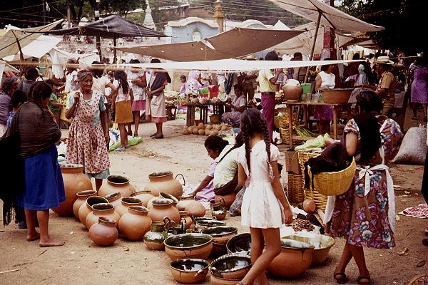
Ceramic items in a Oaxaca street market. Photo: Tony Burton

Ceramic items in a Oaxaca street market. Photo: Tony Burton

However, several million ceramic pieces found in the Oaxaca area have been collected, and systematically cataloged by complexity of form, and hence, difficulty of manufacture and likely “value”. Blanton and his colleagues explore the idea that the distribution of these ceramics can be used to map ceramic production sites and provide a “faint image of the structure of the region’s marketing system”.

In their words, “Presumably, producers would have  distributed themselves in such a way as to maximize their access to potential customers, and to minimize costs. As the clays needed for ceramic making were available virtually everywhere, potters should have therefore tended to locate themselves close to the marketplace or marketplaces where their goods would be sold, to minimize their costs of moving the pottery.” [p 37]

Echoing central place theory, they write that, “A market system and its specialized producers can’t be supported if the producers can’t make a living. They have to be able to supply a sufficiently large number of households that are willing and able to consume a sufficiently large quantity of their goods.” The “demand threshold” is the minimum demand sufficient for a particular product to be worth producing. People will travel further to purchase a higher cost or rarer item (which has a higher demand threshold), which will be produced in only a single or very small number of locations.

According to Blanton and his colleagues, the data for ceramic types in the Valley of Oaxaca confirm that as early as 500 B.C., only one site contained evidence for the most costly (intricate; many steps involved in production) form of ceramics. This site was located in the center of the valley. On the other hand, a larger number of production sites for less costly ceramics were found, scattered around the valley, each site apparently supplying a small local area. While this is not conclusive proof of regular markets, it is certainly strongly suggestive that this is how markets originated in this region.

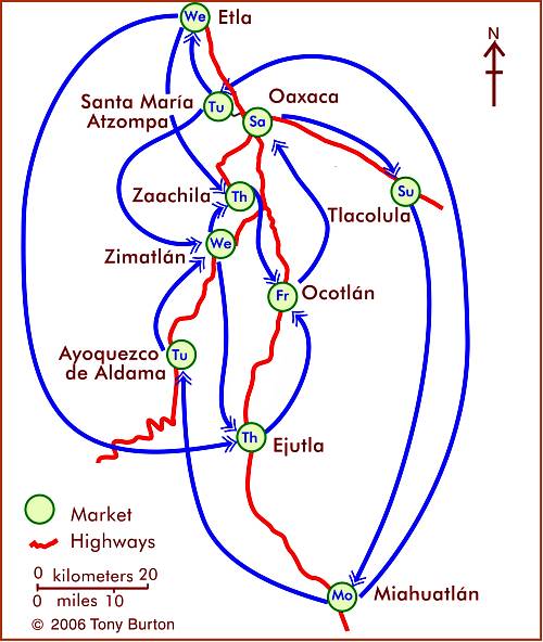
More than two thousand years later, the Oaxaca Valley still has some of the most colorful and vibrant markets in Mexico. The map shows the market day for major markets in the area around the city of Oaxaca. For more details, see Markets in and near the city of Oaxaca.

Source:

Blanton, Richard E., Stephen A. Kowalewski, Gary Feinmann and Jill Appel. Ancient Mesoamerica: a comparison of change in three regions. Cambridge University Press, 1981.

Related posts:

The geography of Mexico’s street markets (tianguis)

 Other  Comments Off on The geography of Mexico’s street markets (tianguis)
Oct 082012
 

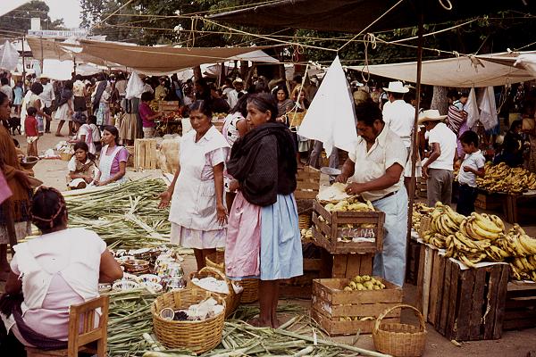
Mexico has some of the finest markets in the world. The variety of produce and other items sold in markets is staggering. But not all Mexican markets are the same. The two major groups are the permanent markets (mercados), usually housed in a purpose-built structure and open for business every day, and the street market or tianguis, usually held once a week.

Street market in Oaxaca. Photo: Tony Burton

Street market in Oaxaca. Photo: Tony Burton

Most tianguis temporarily occupy one or more streets or a public square, though some also use privately-owned land. The origins of the tianguis lie in pre-Columbian times, whereas mercados are a much more recent innovation. In this post, we focus on the tianguis.

The geography of a street market or tianguis

The merchants selling goods in a street market generally visit several markets each week, on a regular rotation (see map for an example of a weekly cycle of markets around the city of Oaxaca). In terms of economic geography, weekly markets allow merchants to maximize their “sphere of influence” and exceed the sales “threshold”, the minimum sales required for them to make a profit, even if they are selling items that may not cost very much, and for which individual consumers are not prepared to travel very far. By visiting, say, four markets a week, these merchants effectively quadruple their potential customers. In terms of social and human geography, these weekly markets are a valuable means of communication, and news from one community quickly travels, via the merchants, to another.

At the same time, these markets give consumers access to a much wider range of goods than would otherwise be possible.

The map shows the market day for major markets, and the major weekly marketing cycles, in the area around the city of Oaxaca. With the exception of Oaxaca city (population 480,000) and Miahuatlán (33,000), all the other towns have populations between 13,000 and 20,000. The merchants at such markets generally carry their wares from village to village on the days of their respective markets. Some local farmers also sell their produce at such markets. For more details, see Markets in and near the city of Oaxaca.

The weekly cycle of markets in and around the city of Oaxaca, Mexico. Map: Tony Burton. All rights reserved.

Mexico has a very long history of street markets, certainly dating back more than two thousand years. The Spanish conquistadors saw, first hand, the very large market of Tlatelolco, in what is now Mexico City, which attracted between 40,000 and 45,000 people on “market day”, which was held every five days.

Markets enabled people living in one region to trade goods produced in another region. In the case of food items this allowed residents of the “hot lands” (tierra caliente) to gain access to food items coming from the “temperate lands” (tierra templada). Some ancient settlements in Mexico are located close to the division between either tierra caliente and tierra templada [usual elevation about 750 meters above sea level] or tierra templada and “cold lands” (tierra fria), at an elevation of about 1800 meters a.s.l. These locations clearly favored the trading and exchanging of items from one major climate zone to another.

Food was by no means the only item traded in markets. Many plants with medicinal value were traded, as were others used for construction materials. It was also common to trade textiles, minerals and household items such as baskets, ceramics and grinding stones, as well as salt, prized feathers and animals.

Even today, most Mexican markets have a distinctive spatial pattern of stalls, with vendors of similar items setting up side-by-side, allowing for comparison shopping. It is a relatively easy and revealing fieldwork exercise to map a Mexican market and then analyze the distribution of different kinds of goods.

We looked in a previous post at how the same basic principle applies to the distribution of shops in many towns and cities.

While most markets traded a variety of items, a handful of specialist markets emerged, especially in the Mexico City area. For example, there were specialist markets for salt in Atenantitlan, dogs (as a source of food) in Acolman, and for slaves in Azcapotzalco and Iztocan.

In a future post, we will look at the origins of the tianguis in the Oaxaca region, a region that is still one of the most fascinating areas in Mexico for markets of all kinds.

Further reading:

Related posts:

The growth and expansion of Wal-Mart in Mexico

 Mexico's geography in the Press, Updates to Geo-Mexico  Comments Off on The growth and expansion of Wal-Mart in Mexico
May 052012
 

Much recent attention in the USA and Mexico has focused on the allegations of bribery related to Wal-Mart de México.  Interestingly, the company has a rather long history in Mexico. It started in 1958 when Jerónimo Arango and his brothers Placido and Manual started a company called Cifra and opened a deep discount store in Mexico City named Aurrera Bolivar. It was inspired by the E.J. Korvette discount store in New York City. The store was an immediate success, helped by sponsorship of the popular TV show, La Pregunta de los $64,000 pesos (“The $64,000 Pesos Question”).

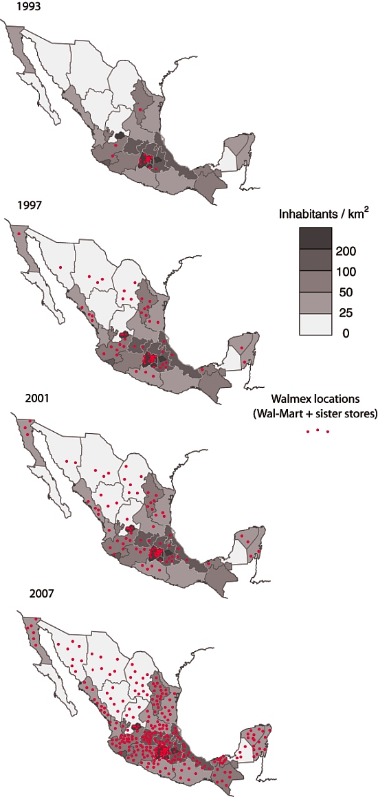
Wal-Mart's expansion across Mexico, 1993-2007

Wal-Mart's expansion across Mexico, 1993-2007. Click map to enlarge

By 1965 Cifra had eight Aurrera stores in the Mexico City area as well as a Superama grocery store and VIPS restaurant. Cifra and Jewel-Osco of Chicago formed a joint venture and by 1970 they opened the first Bodega Aurrera discount warehouse stores and Suburbia department stores. Their first hypermarket, Gran Bazar, followed in 1976. Shares in the company were sold to the public in 1977.   By serving low-income customers, the company managed to survive the financial crisis of 1982.  In fact during the 1980s it increased sales by an average 20% per year reaching US$550 million by 1989.

Rapid growth continued in the 1990s. By 1992 there were 38 Almacenes Aurrera supermarkets, 29 Bodega Aurreras, 34 Superamas, 29 Suburbias (department stores), 59 VIPS, as well as 15 El Portón restaurants. Almost all of these were located in the densely populated Mexico City and surrounding State of Mexico. Phenomenal growth continued in 1992 with 23 new units added. Cifra B shares increased forty-fold in just five years from the start of 1988 through the end of 1992. At that time, Cifra had a sophisticated, state-of-the-art data system for inventory control and monitoring customer preferences.

In 1991 Cifra formed a joint venture with the US firm Wal-Mart (founded in 1962, four years after Cifra). Unlike Cifra, whose early growth was based on an enormous urban area, Wal-Mart USA’s incredible early growth concentrated on rural areas. Initially the joint venture focused on trade and the members’ only Club Aurrera, which was soon renamed Sam’s Club. The first map shows the distribution of Wal-Mart stores in 1993. Expansion of new outlets throughout Mexico was only slightly slowed by the 1994 financial crisis.

By 1995, there were 22 Sam’s Clubs, and 11 Wal-Marts, 35 Almacenes Aurrera, 58 Bodegas Aurrera, 36 Superamas, 33 Suburbias, as well as 114 VIPS restaurants. One of the new Wal-Mart Supercenters was the largest in the world. The signing of NAFTA in 1994 strengthened the joint venture. In 1997 Wal-Mart USA acquired majority interest in Cifra creating Wal-Mart de Mexico or Walmex. The company, which previously had been heavily concentrated in Metro Mexico City, was soon aggressively opening new units in cities throughout the country (see maps).

Recent news reports allege that this aggressive growth may have been facilitated by payments of bribes to expedite construction permits. As of March 2012, Walmex was operating no fewer than 2,106 retail units throughout Mexico. They include 127 Sam’s Clubs, 213 Walmart Supercenters, 94 Suburbias, 385 Bodega Aurreras, 88 Superamas, 358 VIPS and El Portón restaurants, and over 840 Bodega Aurrera Expresses and other small outlets.

Wal-Mart de México is the country’s largest retailer, with sales of over US$24 billion, and largest private-sector employer, with 209,000 employees. These figures make Walmex the dominant player in its sector, well ahead of its Mexican supermarket rivals: Soriana ($8 billion); Comercial Mexicana (Mega, $4.5 billion) and Chedraui ($4.4 billion).

The 2007 map shows how Wal-Mart has now expanded into some areas where the population density is relatively low. The early expansion of Wal-Mart was into areas with high population density, where a single, well-placed store could easily be accessed by a lot of people, and therefore have the potential to be highly profitable. Even with the 2007 distribution, however, there is still a marked north-south divide in access to Wal-Mart, which reflects income disparities in Mexico.

In 2009/10 Walmex acquired Walmart Centroamérica and is now named Wal-Mart de México y Centroamérica, adding 622 retail outlets in Guatemala, El Salvador, Honduras, Nicaragua and Costa Rica, to bring the total number of units it operates (including Mexico) to 2, 728 retail outlets (with sales of about $29 billion) compared to Wal-Mart USA’s 4,468 outlets (with 2011 sales of $447 billion).

Source for maps:  

The maps have been redrawn, based on maps in “Supplier Responses to Wal-Mart’s Invasion of Mexico”  by Leonardo Iacovone, Beata Smarzynska Javorcik, Wolfgang Keller, James R. Tybout. Working Paper 17204  of the National Bureau of Economic Research, Cambridge, MA, USA.

Related posts


Drug gangs diversify their business activities

 Mexico's geography in the Press  Comments Off on Drug gangs diversify their business activities
Jun 282011
 

Wise investors know that diversification is a sound way to protect their resources, and Mexico’s drug cartels have apparently been well educated in this regard. Recent news reports have highlighted two new ways in which Mexico’s drug cartels preserve and grow their wealth: the marketing of pirated merchandise, and the theft and sale of natural gas concentrates.

Marketing of pirated merchandise

According to an article originally published in the Dallas News, Mexico’s drug gangs now make almost as much money from pirated merchandise as from their trade in illicit drugs. By some estimates, the proliferation of pirated brand name goods has resulted in more than 450,000 manufacturing job losses and has caused the demise of many textile, clothing and shoe-making firms. Officials say that pirated videos account for as many as 9 out of every 10 movies sold across the country.

Pirated videos

"Almost original" DVDs for sale in Mexico

Theft of natural gas concentrates

Mexico’s giant Burgos natural gas field, which straddles the northern states of Tamaulipas, Nuevo León and Coahuila, lies in a zone which has become a center for violence in Mexico’s drug wars. Pemex, Mexico’s state-owned oil giant, claims that up to 40% of the gas concentrate produced has been stolen since 2006, as drug gangs have systematically targeted, kidnapped and intimidated oil workers. In some cases, cartels have even constructed their own pipelines to siphon off the gas, before filling their own tankers and driving them across the border using forged documentation.

Pemex has filed suit in Texas against eleven US firms (including Plains All American Pipeline LP, SemCrude, and Western Refining), alleging that they purchased up to 300 million dollars of fuel illegally acquired by drug gangs from Mexican pipelines and then shipped across the border. According to Pemex lawyers, the US firms may have been complicit in the forging of documents required for the gas concentrate shipments to cross the border, and profited (knowingly or unwittingly) from the trafficking of stolen fuel.

Previous posts about the geography of drug trafficking and drug cartels in Mexico:

Geo-Mexico: the geography and dynamics of modern Mexico discusses drug trafficking in several chapters. A text box on page 148 looks at trends in the drug trafficking business and efforts to control it. Buy your copy today to have a handy reference guide to all major aspects of Mexico’s geography!

Consumer shopping habits and regions in Mexico

 Mexico's geography in the Press  Comments Off on Consumer shopping habits and regions in Mexico
Mar 172011
 

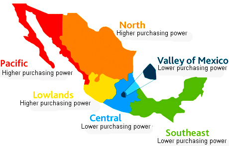
Nielsen, the world’s leading consumer information and research company (offices in more than 100 countries), recently analyzed the shopping habits of consumers in Mexico. From a geographical perspective, one of the most valuable aspects of the study is Nielsen’s use of consumer purchasing habits to suggest a division of Mexico into distinct shopping regions.

The market for consumer goods in Mexico is very large, and has grown rapidly since the 1980s. Mexico is now the world’s 11th most populous nation (112.3 million people in 2010) and has the world’s 11th largest economy. It is also the most populous Spanish-speaking country in the world. Mexico’s size and diversity result in great variations in consumer patterns from one area to another. To achieve maximum success, manufacturers, distributors and retailers in Mexico need to appreciate these regional differences.

Mexico's consumer regions

Mexico's consumer regions. Credit: Nielsen

As we have stressed in previous posts, Mexico has a marked north-south divide. Inhabitants in the north tend to be better-educated and live in smaller households, with higher household incomes and more purchasing power than their counterparts in southern Mexico. The Nielsen study broadly supports this division of wealth, but adds some refinements to the pattern.

The map summarizes Nielsen’s view of the pattern of Mexico’s consumer habits. Throughout the country, small traditional stores (defined by Nielsen as those stores where a salesperson or clerk must be present to serve shoppers) remain a vitally important option for consumer purchases.

Convenience stores and small supermarkets are most popular in Nielsen’s Pacific and North areas. Larger supermarkets are more important in the Valley of Mexico and in the Southeast region.

In all regions, traditional convenience stores are visited frequently, either daily or even twice-daily. Consumers typically visit the nearest supermarket twice a week, with Sunday being the single most popular shopping day. Mid-week supermarket shopping is most common in the Pacific, North and Southeast areas.

Related post:

The distribution of retail activities in the city of Zitácuaro, Michoácan, Mexico

 Excerpts from Geo-Mexico  Comments Off on The distribution of retail activities in the city of Zitácuaro, Michoácan, Mexico
Nov 022010
 

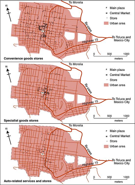
The maps below show the distribution in 1980 of three distinct types of commercial establishments in the mid-sized city of Zitácuaro in Michoacán.

Map of retail activities in Zitácuaro, Michoacán

Retail activities in Zitácuaro, Michoacán. Color version of Figure 22.3 of Geo-Mexico: the geography and dynamics of modern Mexico. All rights reserved.

Founded hundreds of years earlier, the city grew spontaneously, almost organically, with little planning; its population by 1980 was 100,000. Cars were not a necessity. The residents of Zitácuaro did not have to walk far to purchase their basic daily shopping needs. Convenience stores (top map) existed in every  neighborhood. Many (145 out of 393) were genuine “corner stores”, strategically located at street intersections. On average, each convenience store served about  250 residents.

More specialist stores (middle map), selling so-called “shopping goods” such as clothes and furniture, had a very different distribution. A few were located in  residential areas, but most were concentrated in the heavily trafficked central area of the city, in the narrow streets close to the main plaza or zócalo, west of the main highway.

By 1980, a bypass had been opened enabling through traffic to avoid the main congested highway through the center of the city. However, the distribution of specialist stores does not appear to show any close connection to either the old highway or the new bypass.

This contrasts with the distribution of stores connected to auto services (gas stations, auto parts, tire repairs, mechanics) where the preferred locations in 1980 were close to the main highway (bottom map). In the succeeding years, this distribution has changed somewhat. Many of these services have now relocated to the by-pass to better serve the passing traffic.

This post is an excerpt from Geo-Mexico: the geography and dynamics of modern Mexico. Chapters 21 and 22 of Geo-Mexico analyze Mexico’s 500-year transition to an urban society and the internal geography of Mexico’s cities. Chapter 23 looks at urban issues, problems and trends. To preview more parts of the book, click here and use amazon.com’s “Look Inside” feature. Buy your copy today!

Corner stores in Mexico give way to supermarket chains

 Updates to Geo-Mexico  Comments Off on Corner stores in Mexico give way to supermarket chains
May 282010
 

In the past 50 years, Mexico has become a land of supermarkets. Where small corner stores once used to be the source of staples such as bread, milk and fresh vegetables, supermarkets have now taken over in almost every town.

Here is a summary of Mexico’s main supermarket chains:

* Wal-Mart de México (Walmex), easily Mexico’s largest retailer (2009 sales: 22 billion dollars). A subsidiary of the US retail giant Wal-Mart Stores. More than 1,000 supermarkets in Mexico, from medium-sized, low-end stores specializing in low prices, to membership clubs selling flat-screen TVs and patio furniture. Walmex also owns restaurants (including VIPS) and clothing stores. Walmex is gradually expanding into Central America and currently has 519 supermarkets in that region.

* Soriana (2009 sales: 7.6 billion dollars), based in the northern industrial city of Monterrey. Soriana operates more than 500 supermarkets across Mexico. It purchased about 200 stores from smaller rival Gigante. It is opening 40 new stores in 2010.

* Comercial Mexicana (2009 sales: 4.5 billion dollars) is the third-largest retailer, with 231 supermarkets and 73 restaurants. Has faced serious financial problems in past couple of years. Popular on Wednesdays when it slashes the prices of fruits and vegetables.

* Grupo Comercial Chedraui (2009 sales: 4 billion dollars) was founded more than 80 years ago. 142 stores, mostly located in central and southern Mexico, and 21 stores in the USA, catering to the US Hispanic community.

* Grupo Gigante sold most of its supermarkets to Soriana in 2007, but continues to operate its discount format Super Precio, a restaurant chain and a home products store. It also has a joint venture with the USA-based Office Depot.

Chapter 22 of Geo-Mexico: the geography and dynamics of modern Mexico includes an analysis of retail patterns in the mid-sized Mexican city of Zitácuaro, Michoacán.