In the mid-sixteenth century, the Spanish Court was determined to acquire accurate information about everything being encountered in New Spain. This led to a series of censuses and accounts, including the Relaciones geográficas (Geographic Accounts).
The basis for the Geographic Accounts was a 50-question survey, sent to New Spain in 1577. The authorities in each administrative center were instructed to call a meeting of the “Spaniards and other natives in the district”, to find out everything they could about the area’s geography, people and history.
Of the 191 known responses to the 1577 questionnaire, 167 have survived in archives to the present day. Most of the original responses are housed in Spain, in either the Archivo General de las Indias in Seville or the Real Academia de la Historia in Madrid, while a further 43 responses form part of the Benson Latin American Collection in the University of Texas library in Austin. (The library’s webpage about the Relaciones geográficas has several links to images of sample pages and maps).

Map of Zempoala area from the Relaciones Geográficas (1577)
The accounts contain a wealth of information about population, relief, flora, fauna, economic activities and lifestyles. Some also include maps of the areas being described. However these early maps do not follow modern conventions in terms of having a uniform scale across the area being shown, or an orientation that is consistent in terms of compass directions. They are pictorial maps, where the scale varies across the map, and where areas are delimited, or places are linked, without apparent regard for direction.
One such map (see image above) depicts the area around Zempoala (Hidalgo). This is analyzed by Barbara E. Mundy, Associate Professor of Art History at Fordham University, in an online article, Mapping Babel: A Sixteenth-Century Indigenous Map from Mexico, published in The Appendix, a “journal of narrative and experimental history”. In the article, Mundy provides a detailed, step-by-step account of the map, with lots of additional related images and information.
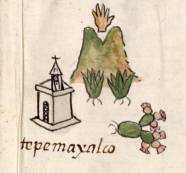
Detail of map, showing Tepemaxalco
Mundy’s analysis reveals several “acts of translation” that have been made by the indigenous artist(s) presumed to be responsible for drawing the map.
For example, the artist(s) made the Spanish paper provided for the map more closely resemble its indigenous counterpart (bark paper), by joining sheets together to create the size they wanted for the map. In addition, unlike modern maps where the viewer is essentially static, with the map details arranged around them, indigenous maps demand changes of perspective, mobile viewers, who have to reorientate themselves depending where they are on the map in order to see things clearly.
Many of the images are a translation, perhaps of similar European images. For instance, like most towns on the map, Tepemaxalco is shown with “a conventional sign for a Christian chapel: a small building drawn in perspective with one side marked by a shadowing grey wash, topped with belfry and cross.”
The map also links the pictograph for each place name to its name written in alphabetic script. “The pictograph for Tepemaxalco (see image) registers some of its Nahuatl components: tepetl, ‘hill,’ maitl, ‘hand,’ xalli, ‘sand’ and co, ‘place of.’ Below, the name is written in alphabetic script, probably introduced by the Franciscans who evangelized this region.”
The dominant pictogram on this map is that for Zempoala (written “Cenpoballa” on the map). Mundy offers an interesting interpretation of this pictograph, which we hope to examine further in a future post.
Further reading
Barbara E Mundy. 2001. The Mapping of New Spain: Indigenous Cartography and the Maps of the Relaciones Geográficas.
Related posts:
- Mexico’s sixteenth century Geographic Accounts: the example of Jiquilpan, Michoacán
- The “Geographic Accounts”: Mexico’s sixteenth century “Domesday Book”
- Beautiful cartography from the seventeenth century: Ysarti’s 1682 map of New Spain
- Mexican place names often have their roots in pre-Hispanic languages and have multiple levels of meaning
- Bringing place names to life in Mexico City
- Mexico’s indigenous place names
Sorry, the comment form is closed at this time.