In April 2010, a large earthquake rattled the Mexicali area, causing significant damage. It was so powerful that it even moved the southern part of California! The magnitude 7.2 earthquake damaged the irrigation infrastructure used by Mexican farmers on land along the lower Colorado River and in the Colorado River delta region.
Mexico and US officials are reported to be discussing the Colorado water-sharing agreement, given the damage done to irrigation facilities following the April earthquake (The OOSKA News Weekly Water Report for Latin America and the Caribbean, 18 August 2010).
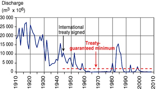
As we noted in an earlier post, a 1944 treaty guaranteed that at least 1750 million cubic meters of water (see graph) would enter Mexico each year along the Colorado River via the Morelos diversionary dam in the Mexicali Valley. The damaged infrastructure means that Mexico is unable to use effectively all of its annual allocation of water from the Colorado. Urgent repairs are underway on pumps, pipelines and irrigation channels, particularly those in the Mexicali region.
Meanwhile, Mexican officials have asked their US counterparts if it is possible to store some of Mexico’s 2010 allocation of water in the Lake Mead reservoir near Las Vegas, until repairs to irrigation systems have been completed.
Earthquakes in Mexico are discussed in detail in chapter 2 of Geo-Mexico: the geography and dynamics of modern Mexico. Mexico’s water resources and water-related issues are the subject of chapters 6 and 7. Ask your library to buy a copy of this handy reference guide to all aspects of Mexico’s geography today! Better yet, order your own copy…

Sorry, the comment form is closed at this time.