Mar 312016
 

The River Atoyac, a river more than 120 kilometers (75 miles) long, in the state of Veracruz, has suddenly dried up. The dramatic disappearance of the river is believed to be due to the collapse of the roof of a cavern in the underlying limestone. This caused the formation of a narrow sinkhole, 30 meters (100 feet) long, that now swallows the river and diverts its water underground.

rio_atoyac-mapa-el-universal

Drainage basin of the Río Atoyac. Credit: El Universal

The collapse happened on Sunday 28 February; residents of the small ranch town of San Fermín heard a thunderous noise at the time. Within 48 hours, the river had disappeared.

The River Atoyac rises on the slopes of the Pico de Orizaba, Mexico’s highest peak. Unfortunately, the cavern collapse occurred only 3 kilometers from the river’s source, leaving almost all of its course dry, with potentially serious consequences for up to 10,000 people living in the river basin who have now lost their usual water supply.

The disappearance of the river will also have adverse impacts on fauna and flora, and jeopardize sugar-cane farming and other activities downstream. The fauna of the river included fresh-water crayfish (langostinos) which were an important local food source.

The municipalities affected are Amatlán de los Reyes, Atoyac, Yanga, Cuitláhuac, Felipe Carrillo Puerto, Cotaxtla, Medellìn and Boca del Río.

The course of the river approximately follows that of federal highway 150D, the main toll highway between the cities of Orizaba and Veracruz.

Related posts

Cleaning up the Juanacatlan Falls, the “Niagara of Mexico”

 Other  Comments Off on Cleaning up the Juanacatlan Falls, the “Niagara of Mexico”
Jan 142016
 

Geo-Mexico has repeatedly lamented the sad state of the Juanacatlán Falls, the “Niagara of Mexico”, near Guadalajara. More than a century ago, they were considered a national treasure. Indeed, in 1899, they were among the earliest landscapes to be featured on Mexican postage stamps.

In 2012, we reported that Greenpeace demands action to clean up Mexico’s surface waters. Greenpeace activists chose to protest at the Juanacatlán Falls to call attention to the poor quality of Mexico’s rivers and lakes. The activists cited government statistics showing that 70% of Mexico’s surface water was contaminated, mostly from toxic industrial dumping, rather than municipal sewage.

Greenpeace activists at El Salto de Juanacatlán, 22 March 2012. Photo: Greenpeace.

Greenpeace activists at El Salto de Juanacatlán, 22 March 2012. Photo: Greenpeace.

Last year, we returned to the theme and looked at how the Juanacatlán Falls had been transformed from the “Niagara of Mexico” to the “Silent River”.

Our concluding paragraph on that occasion bears repeating:

Is it too much to hope that the government, corporations and society in the El Salto area can all come together to remedy this appalling tale of willful mismanagement? Local residents are right to insist on the enforcement of existing water quality regulations and on the implementation of remedial measures to reverse the decline of this major river and its once-famous waterfalls. Even more importantly, urgent measures are needed to reverse the deteriorating public health situation faced by all those living or working nearby.

Finally, some good news. Author and activist John Pint, who has done far more than most to publicize the scenic wonders of Western Mexico (including dozens of places that fall way outside the usual tourist guides) reports that the inflow from the 66-km-long Ahogado River, one of the rivers that feeds into the Santiago River just before the Juanacatlán Falls is being cleaned up, with a dramatic, positive impact on the beauty of the Falls themselves. According to Pint’s first-hand report and photographs – Is Guadalajara’s most infamous waterfall now clean? – the smelly, toxic foam that has marred the Falls for decades has become a thing of the past. While this does not mean the water is completely clean, it is certainly an encouraging start.

The Ahogado River itself continues to receive pollutants, and its water remains heavily contaminated, but a  300-million-peso treatment plant, which apparently began operations in 2012, is removing some of the worse contaminants prior to the river joining the Santiago River. There is still a lot of work to be done here if the Juanacatlán Falls are going to be restored to their former pristine beauty, but Geo-Mexico is delighted to hear that progress is (finally) being made.

What a shame that it took the death of eight-year-old Miguel Ángel López in 2008, and years of adverse effects on the health of local inhabitants, before federal and state authorities took decisive action. Later this year, Geo-Mexico hopes to revisit the Falls for the first time in twenty years to see just how much they’ve improved. Watch this space!

Related posts:

The River Santiago and the Juanacatlan Falls: from the “Niagara of Mexico” to the “Silent River”

 Books and resources, Mexico's geography in the Press  Comments Off on The River Santiago and the Juanacatlan Falls: from the “Niagara of Mexico” to the “Silent River”
Jun 112015
 

In summer 1987, while living in Guadalajara, I entertained a fellow UK geographer, who arrived with a long list of places he wanted to visit. Over the next few weeks, we ticked them off one by one. Near the end of his visit, he asked why I hadn’t yet taken him to see the famous Juanacatlán Falls, the “Niagara of Mexico”, despite them being in his “top ten” places to see. “OK”, I said, “let’s go!”

Traffic was heavy and as we drove across Guadalajara, I could see his impatience building. Finally, he asked me, “Where are they? How close are we?” I replied that we were “fairly close” but that I was absolutely certain that he would recognize them before they came into sight. A few minutes later and he screwed up his nose and said, “Ughh. What’s that smell?” “See?”, I said triumphantly, “I knew you’d recognize them before you saw them!”

Juanacatlán Falls in 1989. Photo: Tony Burton. All rights reserved.

Juanacatlán Falls in 1989. Photo: Tony Burton. All rights reserved.

Even thirty years ago, long before NAFTA, the Juanacatlán Falls were a sorry sight (and source of a worse smell). Since then, and since NAFTA, they have only become worse. These once-majestic falls, the first Mexican landscape on a postage stamp back in 1899, have been reduced to a trickle of foul-smelling effluent. At the start of the twentieth century, the falls provided hydro-electric power for Guadalajara and turned the wheels of a cotton and woolen mill, the ruins of which now stand to one side.

A recent piece of investigative journalism about the River Santiago, the river which created these waterfalls, makes for disturbing reading. It provides plenty of evidence that the rapid increase in factories along the river, mainly post-NAFTA, may have provided 50,000 new jobs, but has also led to worsening water quality to the point where exposure to the river presents a serious public health risk.

In “River of Death“, Steve Fisher lays bare the terrible reality faced by those living and working close to the river. This is a harrowing tale, with heart-rending testimony from several local residents. On a positive note, the related video, Fusion Investigates: Silent River (below) describes how Sofía Enciso and her family have defied death threats and are determined to confront the factories responsible, while demanding that the relevant authorities take action to enforce federal water quality regulations, and start to clean up the river.

Perhaps the most telling single statistic is that precisely zero companies were fined for failing to comply with water discharge regulations between 2005 and 2011.

In the video, the mayor of El Salto, the main town near the Juanacatlán Falls, claims that the river has become polluted in the past thirty years. I guess he must be too young to remember that they were seriously polluted long before that.

Is it too much to hope that the government, corporations and society in the El Salto area can all come together to remedy this appalling tale of willful mismanagement? Local residents are right to insist on the enforcement of existing water quality regulations and on the implementation of remedial measures to reverse the decline of this major river and its once-famous waterfalls. Even more importantly, urgent measures are needed to reverse the deteriorating public health situation faced by all those living or working nearby.

Related posts:

Illegal pipeline connection causes oil spill in northern Mexico

 Mexico's geography in the Press  Comments Off on Illegal pipeline connection causes oil spill in northern Mexico
Sep 222014
 

The illegal tapping of a Pemex oil pipeline in the northern state of Nuevo León caused an oil spill in August 2014 that contaminated a 6.5-kilometer-long stretch of the San Juan River.

According to Víctor Cabrera, state delegate for the Federal Attorney for Environmental Protection (Profepa), about 23 kilometers of channels (mostly irrigation channels) have been affected in total. Profepa advised residents to avoid using water from the places affected and not to consume local fish.

nuevo-leon-oil-spill-Hector Guerrero

Photo by Hector Guerrero

The illegal connection to the Madero-Cadereyta pipeline was first detected on 16 August 2014, and has been attributed to the criminal activities of organized crime. It allowed some 4000 barrels of crude oil to spill into the San Juan River.

The spill affected the agricultural communities of Mexiquito, La Fragua, Soledad Herrera, Santa Isabel, Hacienda Dolores, La Concepción and San Juan, home to approximately 6000 people.

The Nuevo León state governor Rodrigo Medina told reporters that an analysis carried out by water and drainage authorities and the National Water Commission (Conagua) had shown that the local aquifers had not been contaminated. The oil spill did not reach El Cuchillo Dam, located some 70 kilometers downstream from the spill, which is one of three main reservoirs supplying potable water to the Monterrey metropolitan area.

More than 500 workers from Pemex and other organizations have been employed to clean up the spill. Within two weeks, 90% of the oil spilled had been recovered and removed, according to a Pemex report. Officials expect the clean-up work on the river banks and in the irrigation ditches to take another two months to complete.

 Related posts:

Aug 162014
 

Tourism associated with rivers and lakes

So far as tourism is concerned, Lake Chapala is far more important than the other bodies of water within the basin. Only limited recreational activities are practiced in the various man-made reservoirs and in lakes Yuriria and Cuitzeo. Tourism is locally important in Zirahuén the most pristine of the basins lakes, but its small area restricts development prospects. Tourism, including ecotourism, is also locally important in Lake Pátzcuaro, with pronounced seasonal peaks corresponding to school vacations and the annual Night of the Dead. Surprisingly, there are no specialized ecotourism services at Lake Chapala.

Lerma-Chapala Basin

Lerma-Chapala Basin. Cartography: Tony Burton/Geo-Mexico; all rights reserved

The map shows areas of soil degradation in the Lerma-Chapala basin, as well as the locations where agriculture is a major source of water contamination. The environmental impacts of tourism in the basin are concentrated in the major cities such as Guanajuato, San Miguel de Allende and León, as well as in the smaller communities where tourism is of particular importance, such as Chapala and Pátzcuaro.

The lakes in the basin, especially Chapala, have always had more significance than the rivers for recreation and tourism activities. In the nineteenth century, sail canoes plied the waters of Lake Chapala. Fluctuating lake levels since the 1950s have prevented any concerted effort to establish modern water sports (yachting, water-skiing, windsurfing) on the lake, though casual users can be seen sporadically, mainly at weekends and during school holidays. Recreational fishing is virtually non-existent in the basin. Boatmen and fishermen often have conflicting demands.

Potential for ecotourism

Environmental degradation throughout the basin has reduced the number of potential ecotourism locations. The few remaining natural habitats are in urgent need of effective conservation. None of the few small areas of the basin currently protected at a federal level is associated directly with the River Lerma or Lake Chapala. Several tourism hot spots are under extreme pressure, operating at close to carrying capacity (defined as the maximum number of visitors they can handle without adverse environmental impacts). They include the Monarch butterfly reserves, Lake Camécuaro National Park, and the island of Janitzio in Lake Pátzcuaro. Well managed tourism could help finance habitat restoration and protection. Successful planning will require considerable local participation.

Lovers of flora and fauna want to see native and endemic species, rather than imported exotics. Bird-watching is one of the fastest growing recreational activities in the U.S., a huge niche tourism market in a wildlife watching industry worth 10 billion dollars in North America (Stap, 2002). In the basin, bird-watchers have the opportunity to see several endemics, as well as spectacular flocks of the White Pelican (Pelecanus erythrorhynchos), which can be better viewed on the relatively undeveloped southern shore of Lake Chapala than in its breeding grounds far to the north.

The development of horse-back riding, hiking and walking trails holds considerable potential for the future. Niche markets, such as cultural, shopping and eco-tours could all be further developed. Most tourists prefer a mix of experiences; the basin offers numerous, varied tourism possibilities.

Historically, hunting was an important activity in certain areas, particularly in the marshes at the eastern end of Lake Chapala (the ciénega). One ecological issue here, aside from any need to manage wildlife numbers, is the gradual decomposition of the lead-rich cartridges used a century ago. While this needs further study, this is gradually leaching lead into the environment, but is not the only source of the elevated levels of lead that have been reported in fish and lirio samples (Jay & Ford in Hansen & Van Afferden, 127). Careful monitoring is needed to ensure that no health risk is posed to humans.

Tourism exacerbates existing demands for limited supplies of water. This needs to be recognized in tourist-oriented cities such as San Miguel de Allende, Guanajuato and Pátzcuaro. Some recreational and tourism developments are more water demanding than others. Large expanses of grass cause high losses of water through evapo-transpiration especially during the dry season when watering is needed if grass is to be kept green. However, in the rainy season, grass promotes higher infiltration rates, enhancing groundwater recharge. Pressure from public and private gardens for water could be significantly reduced by xeriscaping.

Management is also needed to ensure that chemicals used in gardens, hotel grounds, and hotels do not cause pollution. The misuse of fertilizers and pesticides can have serious deleterious environmental effects. Overfertilization, for example, can increase nitrogen and phosphorus loads on watercourses, promoting eutrophication.

Golf can be one of the least environmentally sound of all recreational activities (Elkington & Hailes 1992). Constructing a golf course may involve habitat destruction and loss of wildlife; its maintenance may require copious quantities of water and agro-chemicals. A single course may use 330,000 cubic meters of water a year, as much as 4,500 people (Walsh, 2004) Aside from the ethical issue of whether water should be allocated to the playgrounds of the rich while the poor go without, golf courses can greatly reduce water consumption with careful design and management. Of Mexico’s 200+ golf courses, at least 23 are located in the basin. Several were built in the past twenty years. Several others are still in the planning stages. More golf courses may attract more retirees and tourists, but decision makers need to consider the possible social and environmental effects of constructing more courses.

References:

  • Hansen, Anne M. & van Afferden, Manfred (ed). The Lerma-Lake Chapala Watershed: Evaluation and Management. New York: Kluwer Academic / Plenum Publishers. 2001.
  • Elkington, John & Julia Hailes. Holidays that don’t cost the earth. The guide to greener holidays. London: Victor Gollancz Ltd. 1992.
  • Stap, Don. “Great Florida Birding Trail” in Audubon Magazine September, 2002.
  • Walsh, J. “War over water”. Golf Course News, October 2004. G.I.Media. 2004

Source:

This post is based on my contribution (on tourism) to the Atlas de la cuenca Lerma-Chapala, construyendo una visión conjunta, published by Semarnat-UNAM-IE, Mexico, in 2006. (The link is to a low-resolution pdf of the entire atlas).

Related posts:

Apr 122014
 

On Thursday, 27 March 2014, Mexican and U.S. officials were on hand to witness a release of water from the Morelos Dam (located on the border, see map) that should help to rejuvenate wildlife in the Colorado River delta. The delta area has been dry for many years.

Map of the Colorado delta

Map of the River Colorado delta. All rights reserved. Click to enlarge.

The agreement between Mexico and the USA allows for a “pulse flow” of water to be released down the Colorado River, which will bring water to the river’s delta in the Sea of Cortés (Gulf of Mexico) for the first time in more than five decades. The pulse is designed to mimic the effects of a springtime snow melt. The pulse flow will amount to a total of 130 million cubic meters of water over a period of eight weeks.

Within 48 hours of the initial release, the water had reached about 50 km (30 miles) downstream, with some of the water infiltrating into the barren soil as it went. The scientists monitoring the release are still unsure whether or not any water will make it as far as the sea, but already there are signs of life returning to the delta region:

  • Update From Colorado River Delta: A Community Gets its River Back

The release of water is part of a pilot project, due to last five years, that will lay the groundwork for possible future agreements to ensure that the delta area receives sufficient water in the future to enable its fauna and flora to survive.

For more about this landmark event, see

You can help restore water to the Colorado River Basin by joining (free) Change the Course, a project of National Geographic and partners. 

Related articles:

Water management progress in the Lerma-Chapala basin

 Books and resources  Comments Off on Water management progress in the Lerma-Chapala basin
Jan 112014
 

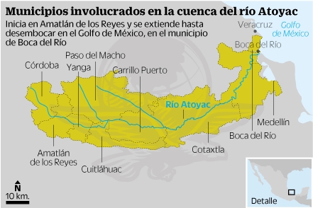
The Lerma-Chapala Basin (see map) is one of Mexico’s major river systems, comprising portions of 127 municipalities in five states: México, Querétaro, Michoacán, Guanajuato and Jalisco.

The basin has considerable economic importance. It occupies only 2.9% of Mexico’s total landmass, but is home to 9.3% of Mexico’s total population, and its economic activities account for 11.5% of national GDP. The basin’s GDP (about 80 billion dollars/year) is higher than the GDP of many countries, including Guatemala, Costa Rica, Honduras, Paraguay, Bolivia, Uruguay, Croatia, Jordan, North Korea and Slovenia.

Lerma-Chapala Basin

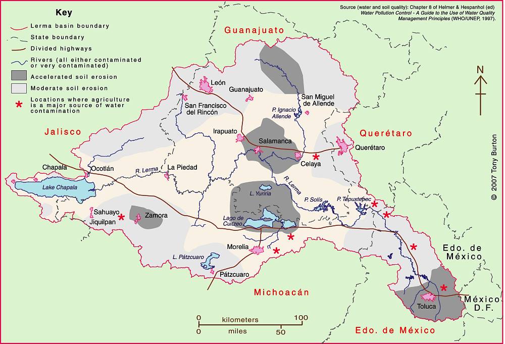
The Lerma-Chapala Basin. Click map to enlarge. Credit: Tony Burton / Geo-Mexico

Given this level of economic activity, it is probably not surprising that the pressures on natural resources in the basin, especially water, are enormous. Historically, the downstream consequence of the Lerma Basin’s agricultural and industrial success has been an inadequate supply of (heavily polluted) water to Lake Chapala.

Following decades of political inactivity or ineffectiveness in managing the basin’s water resources, solid progress finally appears to have been made. Part of the problem previously was a distinct lack of hard information about this region at the river basin scale. The statistics for such key elements as water usage, number of wells, replenishment rates, etc. were all (to put it politely) contested.

Fortunately, several scientific publications in recent years have redressed the balance, and the Lerma-Chapala Basin is now probably the best documented river basin in Mexico. This has allowed state and federal governments to negotiate a series of management agreements that are showing some positive signs of success.

The first of these key publications was “The Lerma-Chapala Watershed: Evaluation and Management“, edited by Anne M. Hansen and Manfred van Afferden (Klewer Academic/Plenum Publishers, 2001). This collection of articles featured contributions from researchers in several universities and research centers, including the University of Guadalajara, Mexican Institute of Water Technology, Autonomous University of Guadalajara, Baylor University, the Harvard School of Public Health and Environment Canada. Click here for my comprehensive description and review of this volume on MexConnect.com.

Perhaps the single most important publication was the Atlas de la cuenca Lerma-Chapala, construyendo una visión conjunta in 2006. Cotler Ávalos, Helena; Marisa Mazari Hiriart y José de Anda Sánchez (eds.), SEMARNATINE-UNAM-IE, México, 2006, 196 pages. (The link is to a low-resolution pdf of the entire atlas). The atlas’s 196 pages showcase specially-commissioned maps of climate, soils, vegetation, land use, urban growth, water quality,  and a myriad of other topics.

More recently, a Case Study of the Lerma-Chapala river basin: : A fruitful sustainable water management experience was prepared in 2012 for the 4th UN World Water Development Report “Managing water under uncertainty and risk”. This detailed case study should prove to be especially useful in high school and university classes.

The Case Study provides a solid background to the Lerma-Chapala basin, including development indicators, followed by a history of attempts to provide a structural framework for its management.

In the words of its authors, “The Lerma Chapala Case Study is a story of how the rapid economic and demographic growth of post-Second World War Mexico, a period known as the “Mexican Miracle”, turned into a shambles when water resources and sustainable balances were lost, leading to pressure on water resources and their management, including water allocation conflicts and social turbulence.”

On a positive note, the study describes how meticulous study of the main interactions between water and other key development elements such as economic activity and social structures, enabled a thorough assessment on how to drive change in a manner largely accepted by the key stakeholders.

The early results are “stimulating”. “Drawbacks and obstacles are formidable. The main yields are water treatment and allocation, finances, public awareness, participation and involvement. The main obstacles are centralization, turbid interests, weak capacity building, fragile water knowledge; continuity; financial constraints; and weak planning.”

Sustainable water usage is still a long way off. As the Case Study cautions, “There is still much to do, considering the system Lerma-Chapala responds directly to a hydrologic system where joint action and especially abundant involvement of informed users is required, to achieve sustainable use of water resource.”

One minor caveat is that the Case Study does not offer full bibliographic reference for all of the maps it uses, which include several from the previously-described Atlas de la cuenca Lerma-Chapala, construyendo una visión conjunta.

Related posts:

May 272013
 

Kudos to the Earth Island Institute for responding to the many criticisms we and others made of a blog article (“Water Pollution Plagues Mexico’s Scenic Pacific Coast”) by pulling it from their website. The following post has been edited to reflect that fact.

Water quality is a serious concern in many parts of Mexico and Geo-Mexico regularly includes short articles about the main issues as well as case studies related to water pollution (see “Related posts” below).

Ron Granich, a regular Geo-Mexico reader who lives in Pátzcuaro (Michoacán) and recognizes our keen interest in Mexico’s water quality kindly drew our attention to a recent article published on the website of the Earth Island Journal. Sadly, the blog article left much to be desired. The article was subtitled, “Tourists largely unaware that industrial pollution from rivers upstream is making them sick”, and attempted to argue that the pollution of Mexico’s Santiago River is a direct cause of the poor water quality of beach towns such as Sayulita.

The slight problem with this thesis is that the Santiago River flows nowhere near Sayulita and has no connection to the miniscule Sayulita River, far to its south (see map). There is no question that the Santiago is polluted. It collects serious pollutants from the major industrial area of El Salto (a short distance southeast of Guadalajara) and from Guadalajara, and from many smaller settlements along the way. More contaminants are added near its mouth, where the swampy delta has been transformed into productive fields, including tobacco plantations.

Main rivers of Western Mexico.

Map of the main rivers of Western Mexico. Credit: Tony Burton / Geo-Mexico; all rights reserved.

Pollution of the River Santiago is particularly evident at the Juanacatlán Falls near El Salto:

After the Juanacatlán Falls, the Santiago flows in a deep, steep-sided canyon for most of its course (which explains why no fewer than three major dams for hydro-electric power have been built along this stretch, including the one at La Yesca) before meandering across its delta to flow into the Pacific Ocean a short distance north of San Blas.

The Santiago River has no conceivable influence on the pollution levels in the rivers near Sayulita and San Francisco or indeed on beaches in their vicinity. This is not to say that those beaches are clean. The beaches of the Nayarit Riviera may indeed have high levels of Enterococcus spp, as we reported recently when looking at the murky world of water statistics in Mexico.

Note on clean water standards in Mexico and the USA:

It is sometimes argued that Mexico and the USA have different standards for what represents “clean water”. For marine (beach) environments, the U.S. limit is 35 Enterococci per 100 ml. of water, and is based on calculating a geometric mean of counts performed over a five week period. This method greatly reduces the impact of peak Enterococci counts. However, the Mexican limit of 100 Enterococci/100 ml. is based on a single sample maximum value. As explained in this US EPA technical document, Water Quality Standards for Coastal Recreation Waters: Using Single Sample Maximum Values in State Water Quality Standards, the two limits are approximately equivalent in terms of water quality. In other words, a geometric mean of 35 Enterococci/100 ml. means that the water is about as clean as a single maximum value of 100 Enterococci/100 ml.

Water quality IS a major concern in much of Mexico, and we applaud the Earth Island Institute for seeking to draw attention to the issues involved, and for their recent action in removing the original article, which helps to ensure that discussions of these issues are based on facts and not on misconceptions.

As always, we welcome discussion about this (and all our posts) via the comments feature. If the comments feature is not visible, simply click the title of the relevant post, and scroll down.

Related posts:

May 132013
 

Mexican rivers are not well suited for navigation and thus have had only a minor influence on Mexico’s historical development. Their most important use has been as sources of irrigation water and hydroelectric power. Mexico’s annual flow of river water (roughly 410 km3) is about 25% more than the St. Lawrence River, but 25% less than the Mississippi River. Most of this flow is in southern Mexico which gets by far the most rainfall. Mexico’s dams have an installed capacity of about 11 gigawatts of electricity, roughly one fifth of the country’s total generating capacity; they don’t operate at full capacity, so they only generate about one eighth of total electricity. Only about a fifth of the total river water is consumed for other productive purposes. This proportion is far higher for rivers in drier northern Mexico where river flow is significantly smaller during the dry winter months.

Fig 6-3 of Geo-Mexico: Rivers of Mexico

Fig 6-3 of Geo-Mexico: Rivers of Mexico; all rights reserved

The two longest rivers in Mexico, the Rio Bravo (Rio Grande north of the border) and Colorado, start in the US state of Colorado (see map). The Río Bravo is about 3000 km (1900 mi) long and forms the border between Mexico and the USA for about 2000 km (1250 mi). Occasionally floods shift its location resulting in border disputes. Though it drains about a quarter of Mexico’s total area, its drainage basin is arid and its total flow is less than 2% of Mexico’s total. The Colorado River, which is almost entirely in the USA, formed a vast delta in the otherwise arid Sonoran desert in northern Mexico. The amount of water reaching Mexico has declined dramatically as a result of the Hoover and Glen Canyon dams and other diversions in the USA (see here, here and here). As a result delta wetlands have been reduced to about 5% of their original extent, and the potential water supply for the rapidly-growing urban centers of Mexicali, Tijuana, Tecate and Rosarito has been compromised.

Interestingly, the Mexican river with the greatest flow, the Grijalva–Usumacinta, does not start in Mexico either (see map). The river has a double name because it is actually a double river, with two branches of similar length which both start in Guatemala. Each branch flows about 750 km (465 mi) through Chiapas before they unite in Tabasco about 25 km from the Gulf of Mexico. Each of the two branches has a flow of about 14% of Mexico’s total. The flow of the combined Grijalva–Usumacinta River is about twice that of the Missouri River in the USA.

There are several other important Mexican rivers. The Lerma River starts in the State of Mexico and flows westward into Lake Chapala and continues to the Pacific Ocean with the name Santiago. The Lerma–Santiago River system is about 1280 km (800 mi) long, the longest river entirely in Mexico. It drains about 6% of Mexico. The Lerma–Santiago, which flows through several states, is one of the economically most important rivers in Mexico because it feeds some of the country’s prime agricultural areas as well as the two largest metropolitan areas: Mexico City and Guadalajara. However, its flow is quite small, only about 2% of the national total.

The flow of the Balsas River, south of the Lerma–Santiago, is about three times that of the Lerma–Santiago. Though it offers some white-water rafting and irrigation opportunities, it is not as important economically. There are numerous rather long rivers that also flow west to the Pacific from the Western Sierra Madre in northwestern Mexico, but these have relatively little water. There are also several rather long rivers in the north such as the Nazas that flow into landlocked basins and either die or feed small drying lakes.

Three major rivers flow into the Gulf of Mexico through the state of Veracruz. The Rivers Papaloapan and Coatzacoalcos start in Oaxaca and flow through southern Veracruz. Their combined flow is nearly 20% of the national total. The Pánuco–Tamesi–Moctezuma River system starts in the State of Mexico and carries nearly 5% to the Gulf of Mexico at Tampico.

Related posts:

Dust, snowmelt and the reduced flow of the Colorado River into Mexico

 Other  Comments Off on Dust, snowmelt and the reduced flow of the Colorado River into Mexico
Oct 262010
 

The Colorado River flows almost entirely in the USA, though its extensive delta is in Baja California. The USA and Mexico have negotiated usage rights designed to guarantee a minimum flow reaching Mexico and to safeguard the water available for numerous cities in the USA that depend on water from the Colorado, and for the rapidly-growing urban centers of Mexicali, Tijuana, Tecate and Rosarito in Baja California.

Even so, the amount of water reaching Mexico has declined dramatically as a result of the Hoover and Glen Canyon dams and other diversions of Colorado River water in the USA. The Colorado River delta has been almost totally dry for most of the last decade.

A new study led by a NASA scientist, links increased human activity in the USA over the past 150 years to earlier annual snowmelt in the Rocky Mountains and reduced flow rates in the Colorado River.

According to the study:

  • lake sediments reveal that between 5 and 6 times as much dust now falls on the Rocky Mountains as 150 years ago – an increase attributed to soil disturbances caused by agriculture and grazing
  • dust settling on snow makes the surface darker, enabling it to absorb more incoming solar energy (ie. the dust changes the albedo of the surface)
  • this increased absorption of solar energy causes earlier snowmelt and more evaporation to enter the atmosphere – peak spring runoff now comes three weeks earlier than 150 years ago
  • this earlier snowmelt exposes vegetation, causing plants to lose more water to the atmosphere than previously – this loss is estimated at almost 1 billion cubic meters (35 billion cubic feet) of water each year
  • this loss of water causes river discharges to be lower than previously; the annual runoff averages less than 95% of the levels found prior to extensive human settlement
  • earlier snowmelt leads to earlier peak runoff into rivers. This complicates water management, especially during the summer.

How much is 1 billion cubic meters of water?

  • sufficient to meet the demands of the entire city of Los Angeles for 18 months
  • more than 50% of the amount of water guaranteed to enter Mexico each year via the Colorado by a 1944 USA-Mexico treaty
  • about 14% of the current volume of Lake Chapala, Mexico’s largest natural lake

How can the situation be reversed/ameliorated?

One successful strategy, mentioned in the article, has been the Taylor Grazing Act (1934). This has improved conditions on public grazing lands, decreasing the amount of dustfall in the Rockies by about 25%. Other strategies are needed since climate change may well exacerbate the effects the additional dust has had on river flows.

Related posts:

Rivers, reservoirs and water-related issues are discussed in chapters 6 and 7 of Geo-Mexico: the geography and dynamics of modern Mexico. Ask your library to buy a copy of this handy reference guide to all aspects of Mexico’s geography today! Better yet, order your own copy…

April earthquake leads to Mexico-USA talks over water-sharing

 Mexico's geography in the Press  Comments Off on April earthquake leads to Mexico-USA talks over water-sharing
Sep 142010
 

In April 2010, a large earthquake rattled the Mexicali area, causing significant damage. It was so powerful that it even moved the southern part of California! The magnitude 7.2 earthquake damaged the irrigation infrastructure used by Mexican farmers on land along the lower Colorado River and in the Colorado River delta region.

Mexico and US officials are reported to be discussing the Colorado water-sharing agreement, given the damage done to irrigation facilities following the April earthquake (The OOSKA News Weekly Water Report for Latin America and the Caribbean, 18 August 2010).

River Colorado discharge entering Mexico, 1910-2010

River Colorado discharge entering Mexico, 1910-2010. Figure 6.5 of Geo-Mexico; all rights reserved

As we noted in an earlier post, a 1944 treaty guaranteed that at least 1750 million cubic meters of water (see graph) would enter Mexico each year along the Colorado River via the Morelos diversionary dam in the Mexicali Valley. The damaged infrastructure means that Mexico is unable to use effectively all of its annual allocation of water from the Colorado. Urgent repairs are underway on pumps, pipelines and irrigation channels, particularly those in the Mexicali region.

Meanwhile, Mexican officials have asked their US counterparts if it is possible to store some of Mexico’s 2010 allocation of water in the Lake Mead reservoir near Las Vegas, until repairs to irrigation systems have been completed.

Earthquakes in Mexico are discussed in detail in chapter 2 of Geo-Mexico: the geography and dynamics of modern Mexico. Mexico’s water resources and water-related issues are the subject of chapters 6 and 7. Ask your library to buy a copy of this handy reference guide to all aspects of Mexico’s geography today! Better yet, order your own copy…

Serious flooding in southern Mexico, August-September 2010

 Mexico's geography in the Press  Comments Off on Serious flooding in southern Mexico, August-September 2010
Sep 082010
 

International media have been focusing attention in recent weeks on massive floods in Pakistan and China. While not on the same scale as the tragedy unfolding in Pakistan, Mexico is dealing with the aftermath of its own very serious flooding in the southern part of the country. Weeks of torrential downpours, with rainfall in many areas reaching more than double the yearly average, have led to widespread inundations.

Floods in Tabasco

The worst flooding has been in the lowland Gulf Coast states of Veracruz and Tabasco, where the channels of major rivers have been unable to cope with the volumes of water fed into them by their network of tributaries. These tributaries begin in the mountainous areas upstream, which received the heaviest rainfalls, in the states of Chiapas and Oaxaca,  which are also experiencing serious flooding. According to the Associated Press and Mexico City daily Milenio, over 300,000 people are directly affected, and tens of thousands have been forced from their homes.

The Papaloapan River has burst its banks and caused record flooding in parts of Oaxaca and Veracruz.  Some of the worst flooding has been in Tlacotalpan, a UNESCO World Heritage Site in a low marshy area about ten kilometers from the Gulf of Mexico, between Veracruz City and Coatzacoalcos.  President Felipe Calderon personally assessed the damage and expressed solidarity with the flood victims by wading a kilometer through the flooded streets of Tlacotalpan.  He ordered six hundred Mexican sailors into the flooded areas to help local residents.

The low-lying state of Tabasco has been hit the hardest.  The homes of over 120,000 people are flooded and over 180,000 hectares belonging to 20,000 people have been lost. This region has repeatedly suffered serious flooding in recent years; a controversial plan for flood protection in this area has never been completed.

Villahermosa, the capital of Tabasco, has been flooded once again. It suffered catastrophic floods in November 2007 and November 2009.  The recent Villahermosa flooding is exacerbated by the controlled releases of water from the massive Malpaso and La Angostura dams in the upper reaches of the Rio Grijalva basin. The dams are essentially filled to capacity; with more rains expected in the next two months, water must be released to provide spare capacity to avoid even greater flooding in the wettest fall months.  The same situation is occurring with the dams in the Papaloapan basin.

Useful ink:

  • Photo gallery of flooding in Tlacotalpan, Veracruz

Rivers, floods and water-related issues are discussed in chapters 6 and 7 of Geo-Mexico: the geography and dynamics of modern Mexico. Ask your library to buy a copy of this handy reference guide to all aspects of Mexico’s geography today! Better yet, order your own copy.

Fascinating new book about the Colorado River

 Books and resources, Excerpts from Geo-Mexico, Maps  Comments Off on Fascinating new book about the Colorado River
Aug 162010
 

The Río Colorado formed a vast delta in the otherwise arid Sonoran desert in northern Mexico where it enters the Sea of Cortés (Gulf of California, see map.) The delta wetlands created ideal conditions for a rich variety of wildlife. The river enters Mexico at the Southerly International Boundary where a gauging station records the river’s discharge. This river is one of the most altered river systems in the world.

Map of the Colorado delta

Map of the River Colorado delta. All rights reserved.

The amount of water reaching Mexico has declined dramatically as a result of the Hoover and Glen Canyon dams and other diversions of Colorado River water in the USA. The few years of higher flows in the 1980s coincide with flood releases from US dams when they had been filled by heavy rains.

The river’s drastically reduced annual discharge violates a 1944 treaty under which the USA guaranteed that at least 1750 million cubic meters would enter Mexico each year via the Morelos diversionary dam in the Mexicali Valley. The Río Colorado wetlands have been reduced to about 5% of their original extent, and the potential water supply for the rapidly-growing urban centers of Mexicali, Tijuana, Tecate and Rosarito has been compromised.

The map and description above come from Geo-Mexico: the geography and dynamics of modern Mexico.

If you are interested in learning more about this river, a great place to start is the recently published book about the Colorado River called Running Dry: A Journey From Source to Sea Down the Colorado River (Jonathan Waterman; National Geographic Books, 2010). Waterman hiked and paddled the length of the river from the Rocky Mountain National Park to its delta in the state of Baja California, Mexico.

For excerpts from the book, see Running Dry on the Colorado and Mighty Colorado River dribbles through Mexico.

Peter McBride, a photographer, accompanied Waterman on his two year trek. His evocative photographs will appear in the book The Colorado River: Flowing Through Conflict (Westcliffe Publishers), due out in September. See Down the Colorado (slideshow) for some examples of his Colorado River photos.

Rivers, reservoirs and water-related issues are discussed in chapters 6 and 7 of Geo-Mexico: the geography and dynamics of modern Mexico. Ask your library to buy a copy of this handy reference guide to all aspects of Mexico’s geography today! Better yet, order your own copy…

Geo-Mexico is reader-supported. Purchases made via links on our site may, at no cost to you, earn us an affiliate commission. Learn more.

Meandering river leads to border dispute

 Excerpts from Geo-Mexico  Comments Off on Meandering river leads to border dispute
Jul 222010
 

The 1848 Treaty of Guadalupe Hidalgo, signed after the Mexican-American War, ceded over half of Mexico’s territory to the USA. A few years later, under the 1853 Gadsden Purchase (Treaty of La Mesilla), northern portions of Sonora and Chihuahua were transferred to the USA. This established the current border between the two countries.

The end to a border dispute caused by a meandering river

The end to a border dispute caused by a meandering river

Minor disputes have occurred since due to the migrating meanders of the Río Bravo (Río Grande) which forms much of the border between Mexico and the USA. Flooding during the early 1860s moved the Río Bravo channel south, shifting an area of about 2.6 square kilometers (1 square mile) from Ciudad Juárez in Mexico to El Paso in the USA. Both countries claimed the area, giving rise to the El Chamizal dispute.

This dispute went to international arbitration in 1911 and was only finally resolved in 1963 with the ratification of the Chamizal Treaty. In 1963, President Adolfo López Mateos met his US counterpart John F. Kennedy on the border formalizing the end of the Chamizal dispute.

The USA and Mexico shared the costs of rechanelling the river in an effort to prevent further migrating of its meanders. The concrete channel is about 50 meters (170 feet) wide and almost 5 meters (15 feet) deep. As we saw in July 2010, with the flooding following Hurricane Alex, even this size of channel is sometimes unable to contain the full flow of the river.

A similar dispute, the Ojinaga Cut, was resolved in 1970.

In El Paso, the Chamizal National Memorial was established in 1966 as a permanent memorial to commemorate the two nations’ laudable  international cooperation, diplomacy and respect for cultural values in arriving at a mutually acceptable resolution to the conflict.

The changing political frontiers of Mexico are the subject of chapter 12 of Geo-Mexico: the geography and dynamics of modern Mexico. If you have enjoyed this post, please consider purchasing a copy of Geo-Mexico so that you have your own handy reference guide to all aspects of Mexico’s geography.

Mexico’s major dams and reservoirs

 Excerpts from Geo-Mexico  Comments Off on Mexico’s major dams and reservoirs
Jul 192010
 

The functions of dams and reservoirs

Mexico’s dams and reservoirs serve many valuable functions. The first is as a source of hydroelectric power. The amount of power that can be generated is a function of the amount of water streaming through the generators and its pressure, which is related to the height of the dam. Just over half of hydroelectric power is generated by dams on rivers which start in southern mountain ranges and flow into the southern portion of the Gulf of Mexico. Most of the rest comes from dams on rivers along the Pacific coast from the Balsas basin all the way north to Sonora.

Postage stamp depicting dam and reservoir

The 50th anniversary of the Mexican Revolution: dam, reservoir and water power.

Hydroelectric power has been important since the early part of the twentieth century. Currently about 22% of the electricity  generating capacity is from hydroelectric plants. The largest hydroelectric plants are on the Grijalva River in Chiapas. Other rivers providing significant hydropower are the Balsas, Santiago, Fuerte, Papaloapan and Moctezuma.

Virtually all Mexican dams, except those in the rainiest southern areas, provide water for irrigated agriculture. This is particularly true in arid northern Mexico. Mexico ranks sixth in the world with about 63,000 cubic kilometers of irrigated agriculture. It is well behind India (558,000), China (546,000), the USA (224,000), Pakistan (182,000) and Iran (76,500). About 23% of Mexico’s cultivated area is irrigated, compared to 99.9% in Egypt, 82% in Pakistan, 47% in China and only 12% in the USA.

Dams also protect against floods, especially in the drier northern areas which are very susceptible to floods from rare but torrential downpours.

In addition, dams provide a source of water for urban populations, especially in the largest metropolitan areas.

Finally, the reservoirs behind dams throughout Mexico are an important recreational resource.

On the other hand, the construction of dams can also have negative effects, including habitat loss, the need to relocate existing residents away from the reservoir site, adverse changes in river flows downstream of the dam and sediment accumulation behind the dam which reduces the reservoir’s capacity.

Chapter 6 of Geo-Mexico: the geography and dynamics of modern Mexico is about water availability, rivers and aquifers; it includes several maps including one showing the relative sizes of the main reservoirs.

Mar 252010
 

The “Niagara of Mexico” is a natural waterfall on the River Santiago as it winds its way from Lake Chapala to the Oblatos Canyon, the deep ravine which prevents the city of Guadalajara from expanding further northwards.

Juanacatlán Falls, 1909

Between the small villages of El Salto (The Waterfall) and Juanacatlan, 17 kilometers east of the Guadalajara-Chapala highway, is the second biggest waterfall in North America, the biggest being Niagara. A bridge with 24 arches spans the falls and links the two villages. The falls became part of Mexican postal history in 1899.

The Juanacatlan falls are shown as a waterfall of immense beauty, a conclusion echoed by tourist guides of the time which speak of a “magnificent spectacle” and the “majestic falls”.

Despite their former fame, the 35-meter-high falls were reduced in the 1980s to a trickle of dirty, evil-smelling effluent from local factories.

Juanacatlán Falls in 1989. Photo: Tony Burton. All rights reserved.

Next to the falls, which at the turn of the 20th century provided hydro-electric power for Guadalajara, now stands the empty shell of a cotton and woolen mill whose wheels were once turned by the falls. Hopefully one day these historic falls will be restored to their rightful place as one of Mexico’s greatest tourist attractions.

Updates:

The text of this post is an edited excerpt from Tony Burton’s Western Mexico, A Traveller’s Treasury (4th edition). All rights reserved.