Mexico shares a 3,169 km (1,969 miles) border with the USA. This is one of the most heavily guarded and frequently patrolled land borders in the world, and a rare example of a land border that separates two countries with very different levels of economic development. These differences in development have, of course, prompted many Mexicans to migrate to the USA, either as seasonal or permanent migrants, and whether “legal” or undocumented.
Some regional geographers have even proposed that a regional division of North America should include a distinctive “border region”, an international region straddling the boundary and including all border crossings and many notable cities. This region experienced rapid economic growth following the signing of NAFTA, when many companies moved to northern Mexico, setting up maquiladora manufacturing plants. The border area has long been a major focus of drugs-smuggling, with border transport of illegal narcotics getting ever more inventive. In recent years, sadly, this same area has become the scene of some of the worst drugs-related violence in the world.
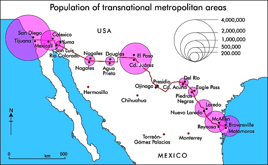
The map shows the 2010 population of the major transnational metropolitan areas of Mexico-USA. The diameter of each circle represents the combined population of the twin cities that have grown up either side of the border. The pattern closely reflects the volumes of overland transport links (road and rail) between the two countries, as well as of commuters who live one side of the border, but work on the other side and cross daily.
The easternmost part of the boundary between Mexico and the USA follows the Río Bravo (Grande). Inevitably, there have been disputes when the river changed its course. Part of the western boundary follows the course of the Colorado River, from which so much water is taken that it now rarely flows into its delta region in Baja California. All the varied boundary and water-rights treaties and agreements between Mexico and the USA are decided via the International Boundary and Water Commission.
Related posts:
- Two examples of trans-border air pollution on the Mexico-USA border
- April earthquake leads to Mexico-USA talks over water-sharing
- The impact of NAFTA on urban growth in Mexico
- Mexico’s major metropolitan areas and cities, 2010
- Mexican migrant farmworkers in the USA
- Is massive migration of Mexicans to the USA a thing of the past?

Sorry, the comment form is closed at this time.