There is still lots of work needed to fully unravel the geological secrets of Mexico’s Volcanic Axis which crosses the country between latitudes 19̊ and 21̊ North. Unlike most volcanic belts elsewhere in the world, this one does not appear at first sight to correspond to any plate boundary. Another of the mysteries of this volcanic region, where igneous upheavals have shaped the landscape for several million years, is the relative dearth of calderas, the “super craters” formed either by collapse or by giant explosions.
While the toponym La Caldera is used fairly commonly in Mexico’s volcanic regions for a volcano or volcanic crater, geologists restrict the term to the much larger landform that results from the collapse or super-explosion of a volcano. Even so, there is still some debate among specialists as to the precise definition of the term caldera.
Geologists have proposed a threefold division of the Volcanic Axis, based on differences in the volcanic landforms, in terms of their type, structure, age, morphology and chemistry.
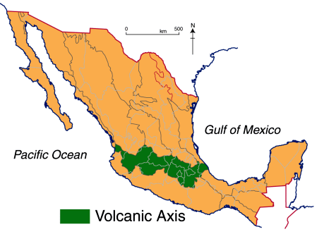
The western sector (see map below) extends from the western coast of Mexico to Lake Chapala (including the lake basin). The central sector covers the area between Lake Chapala and the twin volcanoes of Popocatepetl and Ixtaccihuatl, close to Mexico City. The eastern sector includes these twin volcanoes and extends as far as Mexico’s Gulf Coast.
Mexico’s Volcanic Axis (Fig 2.2 of Geo-Mexico, the geography and dynamics of modern Mexico). All rights reserved.
The only caldera recognized in the western section is that of La Primavera, the forested area west of Guadalajara, whose formation we considered in
- How was the Primavera Forest caldera in Jalisco formed? and
- Watch La Primavera’s geological history unfold (short video animation)
In the central and eastern sections of the Volcanic Axis, several other calderas have been recognized. They include (from west to east):
- Los Azufres
- Amealco
- Mazahua
- Huichapan
- Los Humeros
- Las Cumbres
Los Azufres
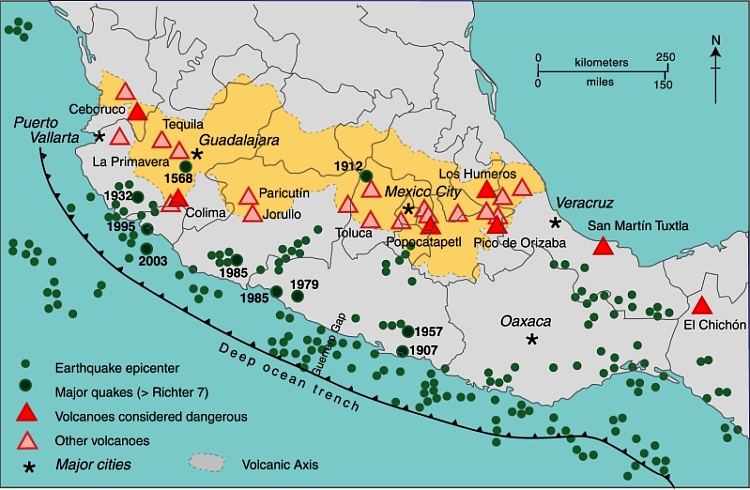
The precise origin of the Los Azufres caldera, in Michoacán, is still debated. The caldera is the site of an important geothermal power station with an installed capacity of 188 MW. (Mexico is the world’s fourth largest producer of geothermal energy, after USA, the Philippines and Indonesia.) The geothermal heat in this area is also used to heat the cabins in a local campground, and to dry wood and process fruit.
Amealco
The Amealco caldera is in the central part of the Mexican Volcanic Axis, midway between the towns of San Juan del Río and Maravatio. It dates from Pliocene times and has been heavily eroded since. It is about 11 km wide and 400 m deep and was the origin of great sheets of pyroclastic flow deposits (ignimbrites) with a total volume of around 500 cubic km.
Mazahua
Mazahua is a collapse caldera, 8 km in width, near the village of San Felipe del Progreso in the western part of the State of Mexico.
Huichapan
The Donguinyó-Huichapan caldera complex is 10 km in diameter and in the central sector of the Volcanic Axis. It appears to be two overlapping calderas, dating from around 5 million and 4.2 million years ago respectively. The rocks from the older caldera are intermediate to basic in composition, while those from the more recent caldera are acidic (high silica) rhyolites.
Los Humeros
The Los Humeros caldera is in the state of Puebla, close to its border with Veracruz. It is 55 km west-north-west of the city of Xalapa (Veracruz), relatively close to Teziutlán (Puebla). The main caldera (summit elevation 3150 m) is about 400 m deep and roughly oval in shape, with a diameter which varies from 15 to 21 km. It was formed about 460,000 years ago by the collapse of the underground magma chamber. Prior to collapse, lava emitted from this vent had covered 3500 square km with ignimbrite. Later, two smaller calderas formed nearby, with ages of about 100,000 years (Los Potreros caldera) and 30,000 years (El Xalapazco) respectively. Volcanic activity in this area has been utilized to produce generate geothermal power (installed capacity: 40 megawatts).
Las Cumbres
The easternmost caldera in Mexico is Las Cumbres, 15 km north of Pico de Orizaba, Mexico’s highest volcano, and close to the state boundary between Puebla and Veracruz. The Las Cumbres caldera was originally believed to be an explosion super-crater, but geologists now think that it was created due to the partial collapse of the eastern flank of the original volcano, between 40,000 and 350,000 years ago. The collapse of the side of Las Cumbres produced a huge debris avalanche (total volume estimated at 80 cubic km, which extended up to 120 km in the direction of the Gulf of Mexico.
Lake Alchichica
According to Dra. Esperanza Yarza de la Torre in Volcanes de México (UNAM; 1984), Lake Alchichica in the Oriental Basin near Puebla occupies another caldera. The basin has several shallow lakes, known locally as axalpazcos (“sandy basin with water” in the indigenous Nahuatl language). These occupy shallow craters (or in one case a caldera) and are largely sustained by ground water. The largest of the lakes, in a caldera, is Lake Alchichica, which has a diameter of 1888 meters, an area of 1.81 square km, and lies at an elevation of 2320 meters above sea level. The rim of the caldera rises 100 m above the lake level. The lake is used for irrigation. This lake is claimed to be Mexico’s deepest natural lake with a maximum depth of 64 meters, and a mean depth of 38.6 meters.
Main sources:
- Gerardo J. Aguirre-Díaz & Fred W. McDowell. 1999. Volcanic evolution of the Amealco caldera, central Mexico. United States Geological Society. Special Paper 334.
- Esperanza Yarza de la Torre. 1984. Volcanes de México. UNAM.
Want to read more?
- Use the site’s tag system (left hand side of the page) to find lots more posts about Mexico’s volcanoes, geology and landforms.
Sorry, the comment form is closed at this time.