Hidden Beach, aka Beach of Love, reopens

 Mexico's geography in the Press  Comments Off on Hidden Beach, aka Beach of Love, reopens
Sep 012016
 

Mexico’s famed Hidden Beach (Playa Escondida), aka as the Beach of Love (Playa del Amor), has reopened for limited tourism following a three month closure  for cleaning and restoration work.

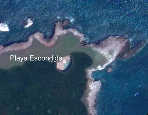
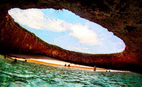
The beach is on one of the small, uninhabited Marieta Islands, in the Marieta Islands National Park, off the west coast of Mexico, and relatively close to the resort of Puerto Vallarta. It is one of Mexico’s most beautiful small beaches, looking from the air (image) like an “eye to the sky”.

Playa Escondida. Source: Google Earth. Scale: The beach is about 30 m (100 ft) long.

Playa Escondida. Source: Google Earth. Scale: The beach is about 30 m (100 ft) long.

In earlier posts, we considered how Playa Escondida (“Hidden Beach”) was formed and also looked at the not inconsiderable downside to publicizing one of Mexico’s most beautiful beaches.

After a study by University of Guadalajara researchers found that local coral was dying and argued that the beach could support no more than 625 visitors a day (compared to the estimated 2500 who visit it on vacation days), federal authorities closed the beach and prohibited access while they considered how best to regulate future visits.

Mexico’s National Protected Areas Commission (Conanp) has now announced new regulations governing visits to the island and to the beach. It is limiting visitors to 116/day, well below the University of Guadalajara figure for carrying capacity of 625/day/.

In addition, no single group may have more than 15 members. No diving is allowed. Fins, face masks and snorkels are all prohibited. Visits have a strict time limit of 30 minutes. The beach, visted by more than 125,000 in 2015, will be completely closed two days each week for maintenance and monitoring.

Only time will tell if these measures will be sufficient to ensure that this particular gem of Mexico’s hundreds of amazing geosites will still be there for future generations to admire and appreciate.

Related posts

How was Playa Escondida (“Hidden Beach”) formed?

 Other  Comments Off on How was Playa Escondida (“Hidden Beach”) formed?
Jun 022016
 

Following on from our look at the potentially disastrous environmental consequences of publicizing Playa Escondida (“Hidden Beach”), one of Mexico’s most beautiful small beaches, we take a look at how this extraordinary beach was formed.

Playa Escondida. Source: Google Earth. Scale: The beach is about 30 m (100 ft) long.

Playa Escondida. Source: Google Earth. Scale: The beach is about 30 m (100 ft) long.

Playa Escondida is on one of the small, uninhabited Marieta Islands, in the Marieta Islands National Park, off the west coast of Mexico, and relatively close to Puerto Vallarta.

playa-escondida

The beach is an “eye to the sky” and is aptly described by travel writer Brandon Presser, as follows:

At the center of Isla Redonda [is] a quirk of nature seen only on the pages of a fantasy novel—a sandy beach carved into the rounded core of the island like the hole of donut. Although completely invisible from the shoreline, a bird’s eye view reveals lapping crystal waters and an empty dune like dazzling colors at the end of kaleidoscope’s funnel.”

The Marieta Islands are formed of volcanic rocks and are an extension of Mexico’s Volcanic Axis.

Just how was this beach formed? Prosser describes two alternative suggestions. The first is that the volcanic rocks were not uniform in composition and hardness but had differences in resistance to subaerial weathering and erosion. According to this theory, the weaker, less consolidated rocks were eroded more quickly than the surrounding rocks to leave a giant chasm in the ground. This chasm was then breached on one side by marine action.

The alternative theory mentioned by Prosser, and the only one mentioned (though without citation) by wikipedia, is that the chasm was formed by human activity, specifically by the Mexican military who undertook bombing practice in and around the islands prior to when the area was given National Park status.

Coastal geomorphologists might argue the case for considering a third theory, involving the formation, first, of the cove on the outer coast of the island, followed by a combination of marine and subaerial action to exploit a line of weakness in the volcanic rocks to create a landform known as a geo (a narrow, deep, cleft extending inland from the coast). This geo may have gradually lengthened over time, by continued cave formation at the head of the geo, with marine erosion at the back of the cave opening up a blowhole, a small opening to the sky. A sequence of collapses and blowhole formation, over time, may have created Playa Escondida, where the interior beach is the base of a former blowhole, where the roof has collapsed and the material subsequently removed by marine action or pounded into beach sand.

Whatever the explanation, this particular geomorphosite is one of Mexico’s many natural treasures, and one well worth preserving for future generations.

Related posts

Beach replenishment needed in Quintana Roo

 Mexico's geography in the Press  Comments Off on Beach replenishment needed in Quintana Roo
Mar 022015
 

Officials in Quintana Roo claim that beach replenishment in the state requires the investment of at least 500 million pesos (about 35 million dollars) in the next few years, and are asking for federal help.

After Hurricane Wilma in 2005, many beaches in Quintana Roo were badly damaged. Following the hurricane, initial beach restoration efforts were funded by the federal Tourism Secretariat, with maintenance then passed over to local (municipal) authorities and the state government. The restoration program included the planting of more than 8,000 palm trees in an effort to help stabilize the coast. However, storms in late 2014 caused considerable damage to beaches, especially the Gaviota Azul beach in Punta Cancún, prompting tourism representatives to call for renewed investment in restoration.

State officials have singled out five areas where the beaches are of particular concern:

  • Cancún
  • Playa del Carmen
  • Isla Mujeres
  • Cozumel
  • Holbox Island

Quintana Roo has budgeted 5 million pesos in this year’s budget to complete the five Environmental Impact studies needed prior to applying for federal funding.

In related news, four Quintana Roo towns have applied for Magic Town status:

  • Tulum
  • Holbox
  • Isla Mujeres
  • Felipe Carrillo Puerto

Quintana Roo currently has only one Magic Town: Bacalar.

The Tourism Secretariat has previously announced that it plans to add 17 towns to the list this year, bringing the total by year-end to 100. Towns that have applied for Magic Town status will be evaluated in June this year, with decisions expected to be announced in July. Given the number of towns submitting applications, some locations are clearly going to be disappointed in this round of nominations.

Related posts:

Five Mexican beaches gain international Blue Flag certification

 Mexico's geography in the Press  Comments Off on Five Mexican beaches gain international Blue Flag certification
Jun 032013
 

For the first time ever, five Mexican beaches have been awarded Blue Flag certification. The Blue Flag system is a voluntary, international eco-label program run by the non-government, non-profit organization the Foundation for Environmental Education that recognizes beaches where water quality is excellent, where information and environmental education is readily available, and which are well managed, with high standards of safety and services. The announcement was made in Copenhagen, Denmark, where Blue Flag certification was given to 3100 beaches and 625 marinas worldwide.

Blue flag beaches in Mexico 2013

Mexico’s five Blue Flag beaches (see map) are:

  • Chahué, Santa María de Huatulco, Oaxaca
  • Chileno, in Los Cabos, Baja California Sur
  • Delfines, in Cancún, Quintana Roo
  • El Palmar, in Zihuatanejo, Guerrero
  • Nuevo Vallarta Norte, on Banderas Bay in Nayarit

What does the Blue Flag system take into account?

The Blue Flag beach criteria are grouped into four main categories:

1. Environmental Education and Information

The beach must host at least 5 environmental education activities and display information about:

  • coastal zone ecosystems and natural, sensitive areas in the coastal zone
  • bathing water quality
  • the Blue Flag system
  • the code of conduct for the beach area

2. Water Quality

  • Water quality must be “excellent” in line with international standards
  • The beach must not receive any industrial or sewage-related discharges
  • Any nearby coral reefs must be monitored to ensure they remain healthy
  • Algae, seaweed, etc., should be left on the beach unless it adversely affects beach quality

3. Environmental Management

  • A beach management committee must conduct regular environmental audits
  • The beach must comply with coastal zone planning and environmental legislation
  • The beach must be clean, with sufficient waste disposal and recycling bins
  • There must be adequate and clean sanitary facilities
  • Regulations must prevent unauthorized camping, driving and dumping
  • Regulations concerning beach use by domestic animals must be enforced
  • Sustainable means of transportation must be promoted in the beach area

4. Safety and services

The beach must have:

  • first aid equipment and an adequate number of lifeguards and/or lifesaving equipment
  • a system to manage beach use and prevent conflicts and accidents
  • emergency plans to cover any unexpected pollution event
  • safe access to the beach and regular safety patrols
  • a supply of potable drinking water
  • access and toilets for persons with disabilities
  • a map showing the location of all facilities

Related posts: