Apr 252016
 

Cuatro Ciénegas (“Four Marshes”) is a city and municipality in the northern border state of Coahuila. Founded in 1800, it has some historical significance, since it was the birthplace of Venustiano Carranza, Mexico’s president from 1915 to 1920.

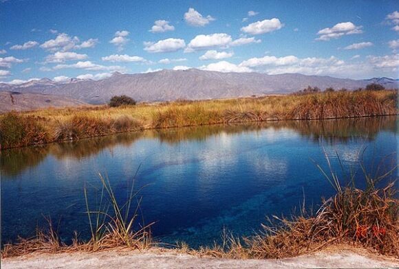
The natural nearby “marshes” are highly unusual. Situated in an arid region (part of the Chihuahuan desert), they include several natural springs that feed more than 200 small ponds and wetlands. Some of the water supporting these unique wetlands, which cover an area of 84,400 hectares, is believed to be more than 200 million years old. The wetlands are an integral part of the UNESCO-designated Cuatro Ciénegas biosphere reserve. The reserve is home to several endemic organisms, including microorganisms such as cyanobacteria that historically helped produce oxygen for the Earth’s atmosphere. The area is considered “a living laboratory of evolution and the origin of life”.

Cuatro Ciénegas. Credit: Nancy T. Wilson (MexConnect)

Cuatro Ciénegas. Credit: Nancy T. Wilson (MexConnect.com)

Human activities in the surrounding area have led to severe water stress on the Cuatro Ciénegas marshes. The basin’s average natural recharge rate (replenishment rate) is about  25 million cubic meters a year, but the average yearly extraction rate, almost all for agricultural use, is close to 49 million cubic meters.

Water stress may be exacerbated in coming years by climate change, which may reduce rainfall while simultaneously increasing evapotranspiration.

Scientists have also identified five particular exotic (introduced) species that pose a significant risk to the long-term quality of the Cuatro Ciénegas wetlands. Whether naturally or deliberately introduced, these five species – African jewelfish, blue tilapia, giant cane (giant reed), Guatemalan fir and tamarisk (salt cedar) – threaten to displace endemic species and change natural nutrient flows and food chains. Guatemalan fir and tamarisk soak up water as they grow, further drying out the marshes (though, eventually, when little water is left, they will die off). The blue tilapia carries parasites that can jump to local species that have no resistance to them. The African jewelfish occupies the same ecological niche as the endemic mojarra and gradually replaces it.

Mexico’s Comision Nacional de Áreas Naturales Protegidas (CONAMP), is now working with the Mexican Fund for Nature Conservation (FNCN) and the Canadian government agency Parks Canada to develop and implement a control and eradication program to tackle these five invasive species. The long-term survival of this highly unusual ecosystem may well depend on this program’s success.

Related posts:

How similar are Mexico’s two major deserts, the Sonoran Desert and the Chihuahuan Desert?

 Other  Comments Off on How similar are Mexico’s two major deserts, the Sonoran Desert and the Chihuahuan Desert?
May 292014
 

There are four desert areas in North America. Two of these areas (Great Basin and Mojave) are in the USA. The other two (the Sonoran Desert and the Chihuahuan Desert) are almost entirely in Mexico, but extend northwards across the border. The Sonoran Desert includes most of the Baja California Peninsula, together with the western part of the state of Sonora. The Chihuahuan desert is the northern section of the Central Plateau, including the northern parts of the states of Chihuahua.

The Chihuahuan Desert has been intensively studied by scientists interested in the possibility of life on Mars – see this New York Times article: Learning About Life on Mars, via a Detour to Mexico.

In a previous post – Why is northern Mexico a desert region? , we saw how the combination of the descending air of the Hadley Cell, which results in surface high pressure, and the effects of rain shadows resulting from neighboring mountain ranges contribute to the low annual rainfall total characteristic of both Mexico’s desert areas.
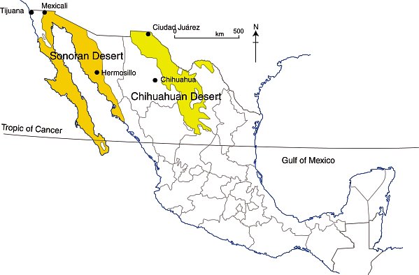
deserts-colorWhile these two deserts both experience an arid climate, they also have many differences.

Area

The Sonoran Desert has an area of about 311,000 square kilometers (120,000 sq mi). The Chihuahuan Desert has an area of about 362,000 square kilometers (139,769 sq mi).

Elevation

The Sonoran Desert is lower in elevation that the Chihuahuan Desert, with some parts (in the USA) lying below sea level. The Chihuahuan Desert varies in elevation from 600–1675 m (1969–5495 ft).

Summer temperatures

The Sonoran Desert tends to have higher summer temperatures than the Chihuahuan Desert, though even in the Chihuahuan Desert, daytime temperatures in summer are usually between 35 and 40̊C (95-104̊F).

Seasonal rainfall patterns

The ratio of winter to summer rainfall decreases from west to east. Most of the Sonoran Desert (to the west) has a bimodal rainfall regime with spring and summer peaks. On the other hand, most of the limited rain that falls in the Chihuahuan Desert comes in late summer.

The Chihuahuan Desert has a mean annual precipitation of 235 mm (9.3 in), though annual totals vary from 150 to 400 mm (6–16 in).

Vegetation, fauna and biodiversity

These seasonal rainfall differences result in significant differences in the vegetation of the two areas.

The bimodal precipitation in the Sonoran Desert provides two flowering seasons each year. Some plants bloom in spring, following winter rains, while others flower in late summer, following summer rains. Typical plants in the Sonoran Desert include columnar cacti (Cereus spp.) such as sahuaro, organ pipe, and cardon, as well as many other types of cacti, including barrels (Echinocereus), chollas (Opuntia spp.) and prickly pear (Opuntia spp.). Other succulent plants are also common.

More than 60 mammal species, 350 bird species, 20 amphibian species, 100 reptile species, 30 native fish species, 1000 native bee species, and 2000 native plant species have been recorded in the Sonoran Desert. The Sonoran Desert includes the Colorado River Delta, which was once an ecological hotspot within the desert, fueled by the fresh water brought by the river, though this flow has become negligible in recent years. See, for example, Will the mighty Colorado River ever reach its delta?

The vegetation of the Chihuahuan Desert is dominated by grasslands and shrubs, both evergreen and deciduous. Common species include tarbush (Flourensia ternua), whitethorn acacia (Acacia constrictor) and creosote bush (Larrea tridentata). The Chihuahuan desert has small cacti; succulent agaves (Agave spp.) and yuccas. Plants bloom in late summer, following the summer rains.

The Chihuahuan Desert is home to about 350 of the world’s 1500 known species of cactus, and includes the fascinating area of Cuatro Ciénegas, which has an unusually high number of endemic plant species and is one of the world’s richest hotspots for locally endemic cacti.

The Chihuahuan Desert is considered to be one of the three most biologically rich and diverse desert ecoregions in the world, rivaled only by the Great Sandy Tanmi Desert of Australia and the Namib-Karoo of southern Africa. However, settlements and grazing have heavily degraded the natural vegetation of some parts of the Chihuahuan Desert.

he Chihuahuan Desert has about 3500 plant species, including up to 1000 species (29%) that are endemic. The high rate of endemism (true for cacti, butterflies, spiders, scorpions, ants, lizards and snakes) is due to a combination of the isolating effects of the basin and range topography, climate changes over the past 10,000 years, and the colonization of seemingly inhospitable habitats by adaptive species. See here for more details of the flora and fauna of the Chihuahua Desert.

Landforms

This basin and range landscape of the Sonoran Desert trends north-northwest to south-south-east. Parallel faulted blocks are separated by alluvial bajadas (broad, debris-covered slopes), pediments and plains, which become wider approaching the coast. Despite being a desert area, this region exhibits many features that have resulted from water action, including wadis, salt flats, stream terraces and alluvial fans.

For a fuller description of the landforms of the Sonoran Desert, see this extract from A Natural History of the Sonoran Desert (edited by Steven J. Phillips and Patricia Wentworth Comus) published by the Arizona-Sonora Desert Museum.

The Sonoran Desert includes the subregion of the Sierra of Pinacate (part of El Pinacate and Gran Desierto de Altar Biosphere Reserve) with its distinctive volcanic cones, craters and lava flows. For more details, see The landforms of the El Pinacate and Gran Desierto de Altar Biosphere Reserve.

The landforms of the Chihuahuan Desert have been molded by tectonic uplift and erosion. Steep-sided but low hills are separated by wide bajadas from former lake beds and alluvial plains, occupying inland basins known as bolsons. Many parts form closed, interior basins with no external drainage. South of Ciudad Juárez, at Samalayuca, is one of Mexico’s most extensive areas of sand dunes. This is one of the most arid parts of the country, with high levels of salinization.

Related posts:
The landforms of the El Pinacate and Gran Desierto de Altar Biosphere Reserve

 Other  Comments Off on The landforms of the El Pinacate and Gran Desierto de Altar Biosphere Reserve
Nov 092013
 

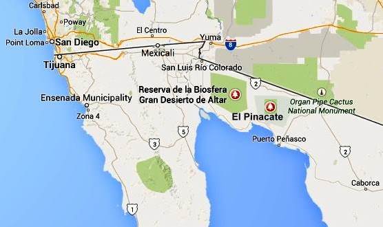
The breathtaking scenery of the El Pinacate and Gran Desierto de Altar Biosphere Reserve in the northern state of Sonora affords visitors a dramatic combination of two very distinct landscape types: volcanic landscapes (El Pinacate) in the east, and sand dunes (Gran Desierto de Altar) towards the west and south.

pinacate-map-googleVolcanic scenery (El Pinacate)

The eastern section of the Biosphere Reserve, El Pinacate, is a dormant volcanic area of around 200,000 ha (2000 sq. km), centered on the El Pinacate Shield (or Sierra Pinacate) which has 3 main peaks: Pinacate, Carnegie and Medio. The El Pinacate Shield is a composite structure, comprised of extensive, successive black and red lava flows, some more than 20 km long, seperated by desert pavement. The El Pinacate Shield boasts a wide array of volcanic phenomena and geological formations. Most of the lava is basaltic (alkaline) in composition, making it relatively fluid when molten; it is mainly of the aa (blocky) type, though some pahoehoe (ropy) lava is also found. The total volume of lava is estimated at between 150 and 180 km3.

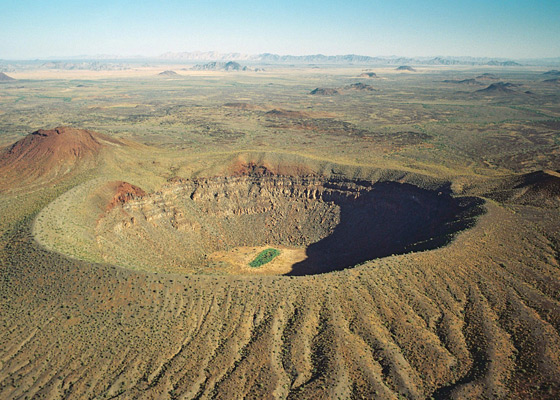
Elegante Crater, El Pinacate

Elegante Crater, El Pinacate (example of a maar) Credit: IUCN Tilman Jaeger

Besides the lave flows, the Pinacate area has more than 400 cinder cones (formed 1.2 million years ago) and several lava tubes. The lava flows and cinder cones are only a prelude to the most visually striking features in the reserve: 10 enormous, deep, and almost perfectly circular maars (steam explosion craters). Maars are believed to originate from a combination of explosion caused by groundwater coming into contact with hot lava or magma and subsequent collapse. The maars of El Pinacate are rivalled only by similar formations in Africa. The largest single maar is El Elegante, formed 32,000 years ago, which is 1,400 meters (4,600 feet) from rim to rim and 140 meters (460 feet) deep. It takes visitors a two to three-hour hike to reach its rim and be rewarded by a spectacular view.

The volcanic forms of El Pinacate are relatively recent in geological terms, most having been formed during the Quaternary Period, which began some 2.8 million years ago. The most recent volcanic activity in this area was only about 11,000 years ago. Some volcanologists believe that some of these craters could become active again in the future, with the potential to form volcanoes up to a few hundred meters in height.

Ron Mader, the founder of Planeta.com and a foremost authority on responsible tourism in Mexico, has marveled at the “bizarre and mind-boggling scenery” of El Pinacate., which so resemble the lunar landscape that between 1865 and 1970 it was used by NASA as a training ground for astronauts preparing for the moon landings. The lava field is so vast and sharply defined that it later turned out that the astronauts could easily recognize it from space!

Sand dunes (Gran Desierto de Altar)

The western and southern parts of the El Pinacate and Gran Desierto de Altar Biosphere Reserve have entirely different scenery. The Gran Desierto de Altar is North America’s largest field of active sand dunes (erg). Several types of dunes are represented here, the tallest reaching 200 meters in height.

The sand needed to form and maintain these dunes comes from the fluvial and deltaic sediments of the Colorado River delta (to the west), the beaches of the Sea of Cortés/Gulf of California (to the south), the River Sonoyta (to the east) and the smaller river and stream fans formed in those parts of the reserve where there are volcanic and granitic mountains.

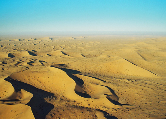
Sand dunes of Gran Desierto de Altar

Sand dunes of Gran Desierto de Altar

Prior to the opening of the Sea of Cortés (Gulf of California), vast amounts of sediment accumulated in this region brought by rivers of which little trace remains today. The creation of the Sea of Cortés, 5.3 million years ago, shortened the rivers and increased their average gradient (rejuvenation), causing them to cut into the pre-existing landscape leaving behind river terraces, remnants of the former higher level floodplains.

The fields of sand dunes of the Gran Desierto de Altar cover more than 550,000 hectares (5700 sq.km.) Several different kinds of sand dunes are found here–linear, crescent-shaped (barchans) and star-shaped–and they can be simple, compound or complex, depending on seasonal changes in the direction and strength of the wind.

Although linear dunes dominate (70%), crescent-shaped complex dunes and star-shaped dunes are of more interest because they exist in only a few locations in the world. Spectacular and very large star-shaped dunes, up to 200 meters high, occur both singly and in long ridges up to 48km in length. Star-shaped dunes possibly evolved from crescent dunes which changed their direction of movement becoming “reversing dunes”. Side winds may account for the multiple arms of some star-shaped dunes.

Other features – Granite massifs

In addition, there are several granite massifs (inselbergs), such as the Sierra del Rosario, emerging like islands from the sandy desert flats and dunes. They range in elevation from 300 to 650 meters above sea level. They represent another remarkable landscape feature harboring distinct plant and wildlife communities.

Main source:

Related posts: