Mar 092015
 

How much geography can you learn from a novel? In some cases, plenty! Robert Richter’s latest novel, Something for Nothing, is a case in point. Set in the swampy lowlands of coastal Nayarit, it is not only a fun read but provides armchair travelers with an easy introduction to the geography of western Mexico.

The book’s author has known this area intimately for more than forty years and his extensive knowledge and deep appreciation for the varied landscapes of this region are evident throughout. The novel is the third in a series of mysteries starring a small-time hustler named Cotton Walters. This particular tale revolves around archaeologists, drug smugglers and a motley crew of colorful local characters.

The history in this novel is entirely believable, and the plot entertaining, but it is the descriptions of the area’s geography that we focus on here.
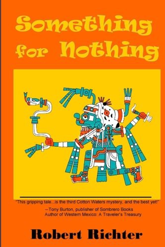
richter-something-for-nothing-2015Early on, Richter offers an excellent overview of the landscapes in this region of Mexico:

“From the highway Mex-15 to the coast, between the San Blas turn on the south and the Tuxpan turn on the north, something was going on in that country of streams and gorges and farmers’ fields. Mex-15 wound through breakneck sierra jungle country where a spur of the Sierra Madre Occidental plunges to the coastal lowlands of mangrove estuaries and shrimp-spawning lagoons, banana plantations and  fishermen’s river-edge villages. Between Nayarit’s two major rivers, Río San Pedro on the north, and Río Santiago on the south, this was rugged backcountry known only by the farmers and jungle scroungers who carved an agricultural living from the wilds. From sierra peak plots to fertile lowland fields, from scattered wild fruit groves hacked from the jungle to smooth, cultivated fields and orchards, from blacktop roads to machete-hacked trails, it’s a country of explosive green growth and extreme geography, a native ground of small towns caught in colonial time warp and hidden bayou settlements as primitive as mythic Aztlan.” (Something for Nothing, 9)

The following paragraph provides the likely human and economic geography background to the “something was going on” phrase used earlier, neatly combining comments about accessibility (or lack thereof), drug smuggling routes, the economic importance of marijuana-growing and questions the possible links between the military and the drugs business:

This was October, end of the rain and hurricane season, and the engorged rivers were running full, impassable except at the few major bridges. The army was stationed at each traffic artery coming out of that country to the main highway. Area contained. It had to be a sweep for marijuana growers or a hunt for major harvest warehouses. Sinaloa to the north was known for its poppy fields and cartel trafficking, Michoacán and Guerrero farther south for Sinsemilla and Acapulco Gold. But the barrancas and jungle milpas of Nayarit were starting to contribute their share of quality pot to the Gross National Product and to the local economies. This year’s harvest had been coming in for some time, and this military presence all along the highway had the feel of maneuvers to eradicate or to confiscate. On the other hand, it could be to expedite the flow of product, too. Quién sabe? [Something for Nothing, 10]

Similarly, this extract from a later chapter links tourism to the volcanic landscapes and appraently laments the loss of wilderness that has accompanied tourism growth, before offering an evocative description of the lowland jungle:

We took an oyster shell road out a back street of Sayulita, not headed out toward the highway, but around a jungle-covered lava spill south into the bosque toward Punta Mita and the northern point of Banderas Bay. Today, that road is driven by Vallarta tourist families in rented Chevy Blazers to luxury hotels. In the winter of ‘72, it was a deer trail that died in an arroyo somewhere in the heart of darkness. Under old growth rain forest canopy we pried boulders out of the way, chopped through windfall palm trunks, and pushed on into an ever-closing tropical wilderness.

… Then suddenly, we entered a clearing under giant iguerra blanca trees and towering palms, draped with vines like decoration and full of grackle cries and parrot song, warblers answering and magpies chattering. Beneath the cathedral-like canopy, a village of stick and thatch huts appeared in the mist and smoke of kitchen fires. Dogs and naked children paused in mid-play to stare at the strange metal monster wheeling in from the twentieth century.

Our modern intrusion rent a momentary silence in the tapestry of village routine. Sunlight pierced the jungle crown with spears of silver light. A prehistoric dust hovered in the air. A rooster crowed. A jay answered. Time warped. As we opened our pickup doors kids scurried or stumbled forward, captured by a spell of awe. My own senses reeled under overload reception. I couldn’t tell the century or the hour of the day in the perpetual jungle shade. I simply absorbed the surroundings, only vaguely conscious and aware. (Something for Nothing, 25-26)

The swamps of lowland, coastal Nayarit comprise a region known in Spanish as the Marismas Nacionales. The area is one of the most distinctive of Mexico’s many extraordinary ecosystems, difficult to explore, teeming with insects, birds and aquatic life, and so far relatively untouched by tourism. Cotton Walters, the book’s main character, and his friend Miguel are navigating their way through the swamps when they are spotted by the Mexican Navy:

I crawled back to Miguel in the stern, pointing and screaming, “Navy! Navy! Ándale! We have to reach the first islands!” Miguel opened it up and cut sharply for shore and the first open passage of river between delta sand spits and jungle-covered islands.

The mouth of the Río San Pedro is more a maze of passages through lowland marshes than a distinctive channel of fast flowing current–except now at the height of the rainy season. The San Pedro oozes into the Pacific rather than runs, and the coast from there north to Mazatlan is an ever changing labyrinth of lagoons and meandering rivulets choked with water lilies and low islands thick with marsh grasses and crawling vines. The lowland character changes with the seasons of dryness and deluge, a seething cauldron of crustacean larvae, breeding shrimp, prawn, oyster, and fish during the rainy season, and arid scrub brush pasture for roaming herds of Cebu cattle and their retinue of herons in the dry months. (Something for Nothing, 31)

Richter’s less-than-flattering description of the town of San Blas nevertheless offers an astute summary of its historical significance:

Yeah, San Blas. The seediest backwater port town on Mexico’s west coast. A town as old as the first buccaneers and as ravaged by time as an old hag. An outpost town on the fringe of four or five different cultures, a smugglers’ town since the first Spanish customs house ran up a flag and started squeezing the citizens for coin of the realm. A place where four centuries of highwaymen have bought and sold their stock in trade, their particular treasure or scheme. (Something for Nothing, 53)

Much later in the novel, Cotton Walters breakfasts at McDonald’s restaurant in San Blas. But this particular McDonald’s has nothing to do with golden arches or globalization:

Breakfast at McDonald’s isn’t what you think if it’s in San Blas. No golden arches. No Happy Meal with a movie toy inside. Just a standard Mexican tile-floor, stucco-wall, wooden-tabled restaurant with the ceiling fan trying to cut its way through the thick October air; the waiter Jorge as grim-faced and slow-paced as ever; and Señora Tinzón de McDonald, long-time widow of some American-Scot refugee of the fifties, waiting to make huevos al gusto or hotcakes. The only restaurant near the plaza that served an early breakfast, by 8 a.m. most of McDonald’s tables were full when I arrived. A couple of expats tried to steady their morning shakes with that first cup of coffee, a few of the soccer-fan tourists in shorts and necklaces of long-nosed cameras were chowing down before a jungle trek chasing bright-colored birds, and a few local shop owners and municipal bureaucrats were hanging out over morning cups of caffeine conversation. An empty small table leaned against the far left wall, (Something for Nothing, 92)

I’ve had the pleasure of eating in the Restaurante McDonad’s of San Blas on several occasions, and, as always, Richter’s powers of observation and description are spot-on.

How much geography can you learn from a novel? Plenty, especially if it written by an observer such as Robert Richter who has such an obvious love for, and deep knowledge of, the locales described.

Related posts:
The extraordinary ecological recovery of Mexico’s Cabo Pulmo Marine Park

 Updates to Geo-Mexico  Comments Off on The extraordinary ecological recovery of Mexico’s Cabo Pulmo Marine Park
Aug 152011
 

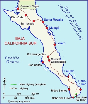
In an earlier post—Can Mexico’s Environmental Agency protect Mexico’s coastline? we took a critical look at proposals for a tourism mega-development near Cabo Pulmo on the eastern side of the Baja California Peninsula. Cabo Pulmo (see map), a village of about 120 people, is about an hour north of San José del Cabo, and on the edge of the Cabo Pulmo National Marine Park (CPNP).

Baja California Sur MapJacques Cousteau, the famous ocean explorer, once described the Sea of Cortés as being the “aquarium of the world.” The protected area at Cabo Pulmo, ideal for diving, kayaking and snorkeling, covers 71 sq. km of ocean with its highly complex marine ecosystem.

Cabo Pulmo is on the Tropic of Cancer, about as far north as coral usually grows. The water temperatures vary though the year from about 20 to 30 degrees C (68 to 86 degrees F).

The seven fingers of coral off Cabo Pulmo comprise the most northerly living reef in the eastern Pacific. The 25,000-year-old reef is the refuge for more than 220 kinds of fish, including numerous colorful tropical species. Divers and snorkelers regularly report seeing cabrila, grouper, jacks, dorado, wahoo, sergeant majors, angelfish, putterfish and grunts, some of them in large schools.

On my last visit to Cabo Pulmo in 2008, local fishermen and tourist guides regaled me with positive comments about the success of the National Marine Park, and the area’s recovery since the area was first protected in 1995. Ever since, I’ve wondered how much their positive take was due to wishful thinking, and how much was due to a genuine recovery in local ecosystems. My doubts have been answered by the publication of Large Recovery of Fish Biomass in a No-Take Marine Reserve in the Public Library of Science (PLoS) ONE journal. The article’s authors present compelling evidence, based on fieldwork, that the area has undergone a remarkable recovery.

Recovery of Cabo Pulmo Marine Park

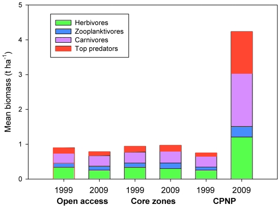
Recovery of fish in the Cabo Pulmo National Marine Park (CPNP). Credit: Aburto-Oropeza et al (2011)

The graph above shows the changes in biomass for three distinct zones of the Sea of Cortés. The open access areas allow commercial fishing. The “core zones” are the central areas of other Marine Parks in the area, including those near Loreto, north of Cabo Pulmo. The CPNP is the Cabo Pulmo National Marine Park, where no fishing is allowed. Clearly, since the CPNP was established, the number and weight of fish inside the park boundaries really have increased rapidly.The total amount (biomass) of fish increased by a staggering 460% over 10 years.

The major reason for the success of the CPNP has been the strength of local residents in undertaking conservation initiatives, and their cooperative monitoring and enforcement of park regulations, sharing surveillance, fauna protection and ocean cleanliness efforts.

The Cabo Pulmo National Marine Park is perhaps the world’s best example of how local initiatives can lead to genuine (and hopefully permanent) environmental protection. The researchers describe it as “the most robust marine park in the world” and say that “The most striking result of the paper… is that fish communities at a depleted site can recover up to a level comparable to remote, pristine sites that have never been fished by humans.”

Here’s hoping that the residents of other parts of Mexico’s coastline threatened by fishing or tourism developments take similar actions and manage to achieve equally positive results for their areas.

Citation:

Aburto-Oropeza O, Erisman B, Galland GR, Mascareñas-Osorio I, Sala E, et al. (2011) Large Recovery of Fish Biomass in a No-Take Marine Reserve. Public Library of Science (PLoS) ONE 6(8): e23601. doi:10.1371/journal.pone.0023601

Further reading:

For an exceptionally informative series of papers (in Spanish) on all aspects of tourism and sustainability in Cabo Pulmo, see Tourism and sustainability in Cabo Pulmo, published in 2008 (large pdf file).

Another valuable resource (also in Spanish) is Greenpeace Spain’s position paper entitled Cabo Cortés, destruyendo el paraíso (“Cabo Cortés: destroying paradise”) (pdf file)

The diversity of species (plants and animals) in Mexico

 Other  Comments Off on The diversity of species (plants and animals) in Mexico
Oct 152010
 

A previous post noted that Mexico’s very wide range of ecosystems make it one of the six most biodiverse countries on earth. We also looked at the states in Mexico with the greatest biodiversity.

Given its deserts, it is not surprising that Mexico ranks first in the world in cactus species and second in reptile species, behind only Australia. Mexico’s tallest cactus is the Pachycereus pringlei (cardón), a relative of the saguaro. It can grow to a height over 19 meters (60 feet) and 1 meter in diameter (39 inches). The largest reptile is the crocodile which can grow to 5 meters (16 feet) in length and weigh over 400 kilograms (880 pounds).  In recent years, several Mexicans have been killed by crocodile attacks.

Marine biodiversityLargely as a result of Mexico’s diverse tropical and subtropical forests, Mexico ranks fourth in the world with 30,000 different types of flowering plants, compared to only 18,000 in the USA and 12,000 in all of Europe. It also ranks fourth in number of amphibian species, which thrive in Mexico’s tropical rainforests. Mexico is also among the top ten in fern and butterfly species.

The temperate forests also harbor significant biodiversity.  Mexico has more species of pine trees and oak trees than any other country.  However, with deforestation, some of these species may be endangered.

Most people are very surprised to learn that Mexico is among the top three in mammal species, along with Indonesia and Brazil. Some of Mexico’s mammals are majestic like the jaguar, some are rather large like the tapir, but many are small and less impressive like bats, shrews, and rodents. Extinction of endemic Mexican mammals is a serious concern. The International Union for Conservation of Nature (IUCN) has listed 11 endemic Mexican mammals as “critically endangered”; 27 as “endangered”, and 14 as “vulnerable”.

Chapter 5 of Geo-Mexico: the geography and dynamics of modern Mexico focuses on Mexico’s ecosystems and biodiversity.  Chapter 30 analyzes environmental issues and trends including current environmental threats and efforts to protect the environment.  Buy your copy today to have a handy reference guide to all major aspects of Mexico’s geography!

Oct 122010
 

Q. Mexico is one of the six most biologically diverse countries on the planet.  But which states in Mexico have the greatest biodiversity?

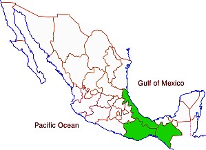
A. In general, the southern states (which receive the highest amounts of rainfall) have the greatest biodiversity: Chiapas, Oaxaca, and Veracruz.

The three most biodiverse states in Mexico

The three most biodiverse states in Mexico

To answer this question in more detail, it is useful to look at different types of plants and animals.

Mammal species are fairly well distributed throughout Mexico. Three of the wettest states lead in number of mammal species.  Chiapas has 205 different species followed by Oaxaca (194) and Veracruz (190). Interestingly, the next highest rated states are in central and northern Mexico: Jalisco (173), Michoacán (163), San Luis Potosí (152), Tamaulipas (145), Puebla (144), Durango (141) and Sonora (139). All states have over 70 mammal species, except for the relatively small states of Aguascalientes (40), Tlaxcala (50) and Guanajuato (65). Mexico as a whole has an impressive 901 mammal species; this figure places it ahead of all other countries.

Mexico is a bird watchers paradise. Veracruz and Oaxaca lead with 635 and 634 different bird species. Chiapas is third with 565 bird species followed by Sonora (445), Jalisco (438), San Luis Potosí (438), Tamaulipas (435) and Michoacán (429). Tlaxcala (86) and Aguascalientes (88) have the fewest number of bird species.

Mexico’s 808 different reptile species places it second, behind only Australia. Relative wet states lead in number of reptile species: Oaxaca (258), Chiapas (224), Veracruz (214) and Guerrero (158). However, the more arid states also have relatively large numbers of reptile species: Sonora (137), Chihuahua (118), Baja California (80) and Baja California Sur (68). Aguascalientes has only 17 reptile species.

Amphibians are very abundant in the wet southeastern states. Chiapas leads with117 amphibian species in followed by Veracruz (109), Oaxaca (106) and Hidalgo (66). Not surprisingly, there are very few amphibian species in desert states. Baja California Sur has only five species while Baja California has 12.

Mexico ranks fourth in the world in number of flowering plant species, behind only Brazil, Colombia and China. Veracruz is the clear leader with 4,907 species, followed by Chiapas (3,833), Oaxaca (3,388) and Jalisco (2,752). States with the fewest species are Aguascalientes (467), Tlaxcala (457) and Baja California Sur (484).

Mexico is also among the world leaders in number gymnosperm (nonflowering plants – mostly conifers and other evergreens) species.  Mexico has more species of pine trees than any other country. Veracruz leads with 31 species, followed closely by Nuevo León (30), Durango (29), Oaxaca (28), Hidalgo (27) and Chihuahua (26). Quintana Roo and Campeche have only one species while Colima and Yucatán have only two.

Ferns are also an important part of Mexico’s biodiversity. Chiapas leads with 693 fern species, followed by Oaxaca (669), Veracruz (534), Guerrero (374) and Puebla (297). States on the Yucatán Peninsula have relatively few fern species: Yucatán (25), Campeche (29) and Quintana Roo (39).

Source for the statistics in this post: Semarnat, El ambiente en números 2010, tabla 21: “Riqueza de grupos de species selecionadas, 2008” (CONABIO) (pdf document).

Several of our previous posts have discussed Mexico’s very wide range of climates, ecosystems and species diversity:

Chapter 5 of Geo-Mexico: the geography and dynamics of modern Mexico focuses on Mexico’s ecosystems and biodiversity.  Chapter 30 analyzes environmental issues and trends including current environmental threats and efforts to protect the environment.  Buy your copy today to have a handy reference guide to all major aspects of Mexico’s geography!

The introduction of sheep caused widespread environmental damage in Mexico

 Books and resources, Excerpts from Geo-Mexico  Comments Off on The introduction of sheep caused widespread environmental damage in Mexico
Jul 032010
 

After the conquest, Spanish settlers introduced numerous Old World species into the New World. The most pernicious introductions were human-borne diseases, which led to the rapid and tragic decimation of the indigenous population. However, most of the introductions were deliberate, made with the intention of increasing the diversity of available food and resources. Among the non-native (exotic) plants and animals introduced were sheep, pigs, chickens, goats, cattle, wheat, barley, figs, grapevines, olives, peaches, quinces, pomegranates, cabbages, lettuces and radishes, as well as many flowers.

The environmental impact of all these introductions was enormous. The introduction of sheep to Mexico is a case in point.

In the Old World, wool had been a major item of trade in Spain for several centuries before the New World was settled. The first conquistadors were quick to recognize the potential that the new territories held for large-scale sheep farming.

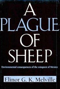
Cover of A Plague of SheepThe development of sheep farming and its consequences in one area of central Mexico (the Valle de Mezquital in Hidalgo) was analyzed  by Elinor Melville in A Plague of Sheep. Environmental Consequences of the Conquest of Mexico.

Melville divides the development of sheep farming in the Valle of Mezquital into several distinct phases. Sheep farming took off during Phase I (Expansion; 1530-1565). During this phase, the growth in numbers of sheep in the region was so rapid that it caused the enlightened Viceroy, Luis de Velasco, to became concerned that sheep might threaten Indian land rights and food production. Among the regulations introduced to control sheep farming was a ban on grazing animals within close proximity of any Indian village. At first the Indians did not own any grazing animals, and consequently did not fence their fields, which inadvertently encouraged the Spaniards to treat the landscape as common land.

During Phase II (Consolidation of Pastoralism; 1565-1580), the area used for sheep grazing remained fairly stable, but the numbers of sheep (and therefore grazing density) continued to increase. By the mid-1570s, sheep dominated the regional landscape and the Indians also had flocks. One of the consequences of this was environmental deterioration to the point where by the late 1570s, some farmers did not have adequate year-round access to pastures and introduced the practice of seasonal grazing in which they moved their flocks (often numbering tens of thousands of sheep) from their home farm in central Mexico to seasonal pastures near Lake Chapala.

This practice of grazing on harvested fields or temporary pastures was known as agostadero. This term originally applied to summer (agosto=August) grazing in Spain but was adopted in New Spain for “dry season” grazing, between December and March. So important was this annual movement of sheep that provision was made in 1574 for the opening of special sheep lanes or cañadas along the route, notwithstanding the considerable environmental damage done by the large migrating flocks. As flock sizes peaked, more than 200,000 sheep made the annual migration by 1579.

In the words of historian Francois Chevalier:

By 1579, and doubtless before, more than 200,000 sheep from the Querétaro region covered every September the 300 or 400 kilometers to the green meadows of Lake Chapala and the western part of Michoacán; the following May, they would return to their estancias.

The prime dry season pastures were those bordering the flat, marshy swampland at the eastern end of Lake Chapala. The Jiquilpan district alone supported more than 80,000 sheep each year, as the Geographic Account of Xiquilpan and District (1579) makes clear:

More than eighty thousand sheep come from other parts to pasture seasonally on the edge of this village each year; it is very good land for them and they put on weight very well, since there are some saltpeter deposits around the marsh.

By the end of Phase III (The Final Takeover; 1580-1600), most land had been incorporated into the Spanish land tenure system, the Indian population had declined (mainly due to disease) and the sheep population had also dropped dramatically. Contemporary Spanish accounts reveal that this collapse was attributed to a combination of the killing of too many animals for just their hides by Spaniards, an excessive consumption by Indians of lamb and mutton, and by the depletion of sheep flocks by thieves and wild dogs. Melville’s research, however, suggests that the main reason for the decline was actually environmental degradation, brought on by the excessive numbers of sheep at an earlier time.

The entire process is, in Melville’s view, an excellent example of an “ungulate irruption, compounded by human activity.” The introduction of sheep had placed great pressure on the land. Their numbers had risen rapidly, but then crashed as the carrying capacity of the land was exceeded. The carrying capacity had been reduced as (over)grazing permanently changed the local environmental conditions.

By the 1620s, the serious collapse in sheep numbers in the Valle de Mezquital was over; sheep farming never fully recovered. The landscape had been changed for ever.

Sources / Further reading:

  • Acuña, R. (ed) Relaciones geográficas del siglo XVI: Michoacán. Edición de René Acuña. Volume 9 of Relaciones geográficas del siglo XVI. Mexico City: Universidad Nacional Autónoma de México. 1987
  • Chevalier, F. Land and Society in Colonial Mexico. University of California Press. 1963.
  • Melville, Elinor G. K. A plague of Sheep. Environmental consequences of the conquest of Mexico. Cambridge University Press. 1994.

Click here for the original article on MexConnect.

Mexico’s ecosystems and biodiversity are discussed in chapter 5 of Geo-Mexico: the geography and dynamics of modern Mexico. The concept of carrying capacity is analyzed in chapter 19. Buy your copy today, as a useful reference book!

The geography of Mexican cuisine

 Other  Comments Off on The geography of Mexican cuisine
Feb 102010
 

Mexican cuisine is extraordinarily varied and has become one of the most popular in the world. Diana Kennedy, the foremost authority on the subject, has devoted her life to researching the regional variations in ingredients, cooking methods and typical local dishes.

The ingredients used reflect different climates and ecosystems (see Geo-Mexico chapters 4 and 5). For instance, corn (maize) tortillas predominate in southern and central Mexico while wheat tortillas are more commonly found in the north of the country.

Pork and hominy stew (pozole) is largely restricted to the Pacific coast states of Jalisco and Guerrero. The grilled beef of cattle ranges in the northern interior of Mexico contrasts with the seafood found along the coast.

Cuisines are strongly influenced by trade routes and migration, especially the arrival of immigrant groups. Mexican cuisine is a fusion of  ndigenous and Spanish cooking, influenced in some regions by Cuban, Italian, French and other migrants.

On a more local scale, miners from Cornwall in the UK who came to work in the silver mines of Real del Monte in the state of Hidalgo brought with them their meat and vegetable-filled pastries called Cornish pasties. These were quickly assimilated into the local cuisine, and pastis, admittedly with some chilies added, are still sold in the town.

[Note: This post is an edited extract from chapter 13 of Geo-Mexico]

For more about Mexican cuisine, visit the amazing award-winning blog Mexico Cooks! and also browse the huge selection of recipes, articles and tips about all aspects of Mexican food and cooking in the “Cuisine” section of MexConnect. ¡Buen provecho!