Mexico’s geomorphosites: Peñas Cargadas, Mineral del Monte, Hidalgo

 Other  Comments Off on Mexico’s geomorphosites: Peñas Cargadas, Mineral del Monte, Hidalgo
Apr 232015
 

This short Postandfly video of an area known as Peñas Cargardas (“Loaded Rocks”) in the state of Hidalgo is the perfect excuse to add to our posts about Mexico’s geomorphosites – sites where landforms have provided amazing scenery for our enjoyment. This area of Mexico is definitely one of my favorites, partly because it is crammed with interesting sights for geographers, including the Basalt Prisms of San Miguel Regla, only a few kilometers away from the Piedras Cargadas, and an equally-stunning geomorphosite.

A few minutes east of the city of Pachuca, the Peñas Cargadas (sometimes called the Piedras Cargadas) are located in a valley in the surrounding pine-fir forest. The rocks comprising the Peñas Cargadas have capricious shapes; some appear to be balanced on top of others. Their formation may well be due to the same processes that formed the Piedras Encimadas in Puebla, which are actually not all that far away as the crow flies.

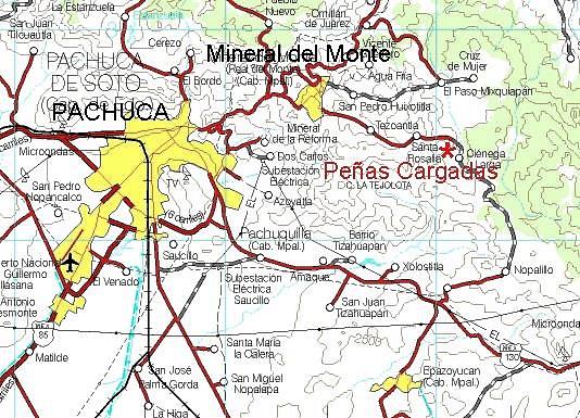
The nearest town, Mineral del Monte (aka Real del Monte) has lots of interest for cultural tourists. Among many other claims to fame, it was where the first soccer and tennis matches in Mexico were played ~ in the nineteenth century, when the surrounding hills echoed to the sounds of Cornish miners, brought here from the U.K. to work the silver mines.

The miners introduced the Cornish Pasty, chile-enriched variations of which are still sold in the town as pastes. Real del Monte also has an English Cemetery, testament not only to the many tragic accidents that befell miners when mining here was at its peak, but also to the long-standing allegiance that led many in-comers to remain here to raise their families long after mining was in near-terminal decline. The town has typical nineteenth century mining architecture. The larger buildings retain many signs of their former wealth the glory.

pachuca-map

The following Spanish language video has some ground-level views, as well as more information about the scenery and the area’s flora:

How to get there

The Peñas Cargadas are about ten kilometers east of Pachuca (see map). From Pachuca, follow signs for Mineral del Monte, and then drive past the “Panteón Inglés” (English Cemetery) in that town on the road to Tezoantla. The Peñas Cargadas are about 3.5 kilometers beyond Tezoantla. This is a great place for a day trip from Mexico City.

Related posts:

Cueva Cheve, Oaxaca, is one of the world’s deepest cave systems

 Other  Comments Off on Cueva Cheve, Oaxaca, is one of the world’s deepest cave systems
Apr 062015
 

Even though most people have never heard of it, Cueva Chevé is one of the deepest cave systems in the world. In 2003, a team led by American speleologist Bill Stone, explored Cueva Chevé, located in the mountainous, pine-clad Sierra de Juárez region of Oaxaca, to a depth of 1484 m (4869 ft). The Cueva Chevé system is thought to have some tunnels (as yet unexplored) that extend even further, to depths beyond 2000 m (6500 ft). By way of comparison, at present the world’s deepest known cave is the Krubera Cave, in the Republic of Georgia, which has a maximum explored depth of 2197 m (7208 ft).

Profile of Cueva Cheve

Profile of Cueva Cheve

How deep might the Cueva Chevé be?

In 1990, colored dye trace experiments showed that there was a hydrological connection between the Chevé Cave and a distant spring (resurgence). This shows that the Cueva Chevé system (including parts not yet explored) has a total vertical fall of 2525 m (8284 ft) over a distance of (north to south) of almost 19 km (11.8 mi).

Because the major risks in exploring any cave system include the possibility of sudden rises in water level, or unexpected water flows through the caves, expeditions to this region are limited to the middle of the dry season (ie February-April). When an expedition gets underway, staging camps are set up underground at intervals, but only in locations believed to be well above flood stage water levels.

Cueva Chevé (see cross section) is shaped like a giant L. The vertical shaft is about 910 m (3000 ft) deep and roughly 3.2 km (2.0 mi) of passages are required to get to the bottom. The remainder is a long, gradually sloping passage that goes on for another 3.2 km and drops roughly 605 m (2000 ft). The cave’s deepest known point is about 11 km (7 mi) from the entrance, where explorers have so far failed to get past a terminal sump.

The air in the cave is relatively warm, with temperatures ranging from 47-52̊ F (8-11̊ C).

Chambers so far explored have been given prosaic names such as “Cuarto de las Canastas” (the Basket Room), “Cuarto del Elefante Negro” (the Black Elephant Room), and “Cañon Fresco” (Fresh Canyon), while named cave formations include the “Taller de Santa Claus” (Santa Claus Workshop). Several parts of the cave system have been found to contain human artifacts, the earliest dating back at least several hundred years.

How to get there

Cueva Chevé is about 140 km (86 mi) north of Oaxaca City via highways 190 and 131.

Related posts

Mexico’s geomorphosites: Ceboruco Volcano

 Other  Comments Off on Mexico’s geomorphosites: Ceboruco Volcano
Apr 072014
 

A short distance west of the crater lake of Santa María del Oro, in the west Mexico state of Nayarit, is Ceboruco volcano which has a cobblestone road to the top. The road starts from the old and picturesque village of Jala, eight kilometers off the main highway (Highway 15). The cornfields around Jala yield some of the largest ears of corn in the world, more than 30 centimeters (one foot) in length, a cause for celebration in the village’s annual August festival. Jala was declared a Magic Town in 2012.

The road up Ceboruco is a geologist’s or biologist’s dream come true, a slowly unfolding series of volcanic forms and different types of vegetation with abundant surprises even for the scientifically expert. Small wonder, then, that the great German botanist Karl Theodor Hartweg was so impressed with Ceboruco when he collected plants here in the nineteenth century. To read more about his discoveries, see The geography of garden flowers, many of which originated in Mexico.

ceborucoNear the top are several short but interesting walks, some in shady, thickly vegetated valleys hidden between towering walls of blocky lava, some along the many overlapping rims of the various old craters of which this complex peak is comprised. Wherever you choose to walk, a multicolored profusion of flowers and butterflies will greet your eyes.

On the south side of an attractive grassy valley at kilometer sixteen, fumaroles send hot gases and steam high into the air reminding us that this volcano is not yet irrevocably extinct. A massive Plinian eruption in about the year 1000 sent ash plumes into the air and devastated a wide area around the volcano. The huge blocks of lava near the summit date from a prolonged series of eruptions in the early 1870s.

Highway 15 cuts through Ceboruco’s lava field a few kilometers after the Jala junction. For those not wishing to brave the cobblestone road up to the volcano, this is a good place to stretch the legs and marvel at the inhospitable, black lava blocks which were spewed out more than a hundred years ago.

This is a lightly edited extract from my “Western Mexico: A Traveler’s Treasury” (link is to Amazon’s “Look Inside” feature), also available as either a Kindle edition or Kobo ebook.

Want to read more about Mexico’s geomorphosites? The link uses Geo-Mexico’s “Site Search” feature.

Related posts:

Mexico’s geomorphosites: El Sótano de las Golondrinas (Cave of the Swallows)

 Other  Comments Off on Mexico’s geomorphosites: El Sótano de las Golondrinas (Cave of the Swallows)
Apr 112013
 

El Sótano de las Golondrinas, in the municipality of Aquismón in the state of San Luis Potosí, is a massive limestone sinkhole (pit cave), one of the largest known in the world. In terms of depth, it is thought to be the second deepest sinkhole in Mexico and is probably in the world’s top 20.

The depth of sinkholes can be difficult to determine. For example, in the case of El Sótano de las Golondrinas, its surface opening is about 50 meters by 60 meters (160 by 200 ft) in size, but is on a slope. The depth on the high side is about 376 meters (1220 ft); the depth on the low side is about 330 meters (1090 ft).

sotano-de-las-golon

Below the surface (see profile) the sinkhole is roughly bottle-shaped. The floor of the sinkhole is about 300 x 135 meters (990 by 440 ft) in area. However, the sinkhole is believed to have formed from the collapse of the roof of an underground cave. As a result, the floor of the sinkhole is not solid rock but rubble that presumably came from the walls and former roof. A shaft on one side extends down at least another 100 m, suggesting that the true floor of the original cave lies at least that far beneath the current rubble-strewn floor.

US photographer Amy Hinkle shot some spectacular images earlier this year in this cave.  The accompanying article highlights the “secret garden” that “nestles 300 meters beneath the surface of the earth”.

The cave’s name (literally “basement of the swallows”) derives from the thousands of white-collared swifts that inhabit the overhanging walls of its interior. They spiral out of the cave every morning over a period of 25-30 minutes and return to their cave homes close to sunset. Large numbers of green parakeets also live in the cave.

The floor of the sinkhole is home to a rich plant life, as well as a diverse selection of  fungi, millipedes, insects, snakes, and scorpions.

The original cave is thought to have been formed by a lengthy period of water erosion along a major fault line in the lower Cretaceous limestone in the Sierra Huasteca (part of Mexico’s Eastern Sierra Madre). Over time, the cave became larger as a consequence of both the water erosion and due to mass movements (landslides, rockfalls) on its walls. Eventually, the size of the cave was so large that its walls could no longer support its roof which then collapsed into the cave, leaving the open air sinkhole seen today. Following heavy rain, short-lived waterfalls cascade down the sides of the sinkhole.

The first documented exploration of El Sótano de las Golondrinas was apparently in 1966. Since that time, the cave has become a popular destination for various adventure sports including rappelling, abseiling and base jumping (no longer allowed).

There are several other very deep sinkholes in the same general area, including Hoya de las Guasguas (with a 202 m deep entrance shaft) and Sótano del Barro (402 m in depth).

Some ornithological studies have found that the bird population of El Sótano de las Golondrinas is decreasing, perhaps due to the disturbance caused by the increasing number of human visitors. To limit disturbance, access and activities are more tightly controlled. For instance, descents into the cave are now strictly limited to daylight hours when the birds are absent, and a no-fly zone has been established around the cave, primarily to avoid helicopter disturbance.

El Sótano de las Golondrinas is yet another outstanding example of a geomorphosite in Mexico. Mexico has literally thousands of geomorphosites. Among those described in previous Geo-Mexico posts are:

References:

Related article: