Apr 112020
 
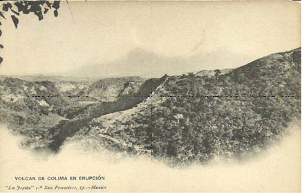
Colima Volcano Erupting. Postcard, La Joyita, ca 1905

This early postcard (cerca 1905) shows smoke billowing from Colima Volcano.

Colima Volcano Erupting. Postcard, La Joyita, ca 1905

Colima Volcano Erupting. Postcard, La Joyita, ca 1905

The postcard was published by a curio store – La Joyita – based in downtown Mexico City at 1ra de San Francisco #13-14. Described by The Mexican Herald in 1898 as one “of the most interesting stores for visitors to be found in the Republic”, it was one of two stores belonging to F. Pardal and Co. and specialized in Mexican opals, drawn work, silver filigree, and other items as well as ancient French and Spanish fans and silk shawls.

For more information about Mexico’s volcanoes:

The mystery of the Alarcon Rise

 Updates to Geo-Mexico  Comments Off on The mystery of the Alarcon Rise
Dec 292014
 

Geologists have discovered that some strange things are happening off the southern coast of the Baja California Peninsula.

In essence, while most of Mexico rests on the North American plate, the Baja California Peninsula is on the gigantic Pacific plate. The Pacific plate is moving slowly northwest and the pressures in the zone where these two plates intersect, under the Sea of Cortés (Gulf of California), has caused a complex series of parallel faults which (further north) link to the California’s San Andreas Fault system. Thus, the Sea of Cortés is an area of heavy seismic activity.

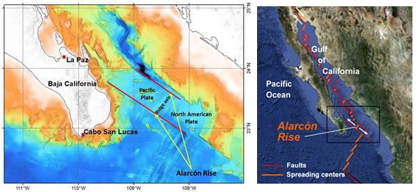
The Alarcón Rise is a 31-mile-long (50 kilometer) spreading center at the mouth of the Gulf of California. Along ocean spreading ridges like the Alarcón Rise, the seafloor is splitting apart as lava wells up from underneath. Credit: (c) 2012 MBARI

Location of the Alarcón Rise. Credit: (c) 2012 MBARI

The Alarcón Rise (see map) is a 50km (30 mi) long “bump” under the Sea of Cortés. New seafloor is being continuously created along the Alarcón Rise as undersea magma rises to the surface and cools to become lava. As the plates continue to move, this lave is then carried away to either side of the Alarcón Rise, allowing fresh lava to take its place, and so on. The rate of sea-floor spreading here is a relatively slow 5 cm (2 in) a year.

The Alarcón Rise has been studied in considerable detail by geologists attached to the Monterey Bay Aquarium Research Institute (MBARI) in California. Using a sonar-mapping robot, they discovered new deep-sea hydrothermal vents.

But their most surprising find was a “Weird Underwater Volcano.

In most zones of sea-floor spreading, the lavas are relatively low in silica and therefore free-flowing. Such lavas are known, on account of their chemistry, as “basic” lavas. (Lavas higher in silica, known collectively as acid lavas, tend to be more viscous and flow less easily. Acid lava volcanoes tend to erupt far more explosively than basic lava volcanoes.)

The curiosity of the Alarcón Rise is that while the vast majority of lava flows along the ridge are basic (basalt) lavas, those associated with at least one volcano are clearly acidic, not basic.

Researchers used a remote-control vehicle to collect samples and explore the volcano, which is 2375 m (7800 ft) below the surface. Samples of the lava show that it is primarily rhyolite with some dacite, with a silica content of up to 77%, the highest of any rock ever found along a mid-ocean ridge, according to Brian Dreyer, a geochemist at the University of California, Santa Cruz. The volcano with acid lava forms a small dome, about 50 meters (165 ft) in height and covers an area of about 1200 meters by 500 meters (4000 feet by 1640 feet). The dome is probably several thousand years old.

The lavas solidified quickly to form angular chunky blocks, some of which then rolled down the sides of the rise to form talus (scree). The individual blocks can be as large as cars or small houses.

The findings suggest that this particular volcano could give rise to hazardous eruptions. It is only 100 km (60 mi) from land and very close to the major tourist areas fringing the coast of Baja California Sur. Any major explosive eruption from this volcano could also cause a tsunami with the potential to devastate settlements on both coasts of the Sea of Cortés (Gulf of California).

Geologists are still working on trying to fully explain this apparent anomaly in lava composition. They have already discarded several ideas, and their current hypothesis is that the magma source was at some point contaminated by seawater, resulting in an unusually high concentration of volatiles such as water, sulfur and chlorine.

Related posts:

Mexico’s geomorphosites: Ceboruco Volcano

 Other  Comments Off on Mexico’s geomorphosites: Ceboruco Volcano
Apr 072014
 

A short distance west of the crater lake of Santa María del Oro, in the west Mexico state of Nayarit, is Ceboruco volcano which has a cobblestone road to the top. The road starts from the old and picturesque village of Jala, eight kilometers off the main highway (Highway 15). The cornfields around Jala yield some of the largest ears of corn in the world, more than 30 centimeters (one foot) in length, a cause for celebration in the village’s annual August festival. Jala was declared a Magic Town in 2012.

The road up Ceboruco is a geologist’s or biologist’s dream come true, a slowly unfolding series of volcanic forms and different types of vegetation with abundant surprises even for the scientifically expert. Small wonder, then, that the great German botanist Karl Theodor Hartweg was so impressed with Ceboruco when he collected plants here in the nineteenth century. To read more about his discoveries, see The geography of garden flowers, many of which originated in Mexico.

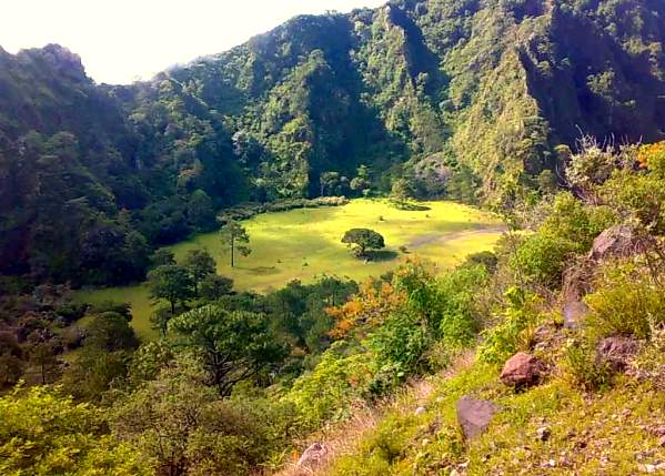
ceborucoNear the top are several short but interesting walks, some in shady, thickly vegetated valleys hidden between towering walls of blocky lava, some along the many overlapping rims of the various old craters of which this complex peak is comprised. Wherever you choose to walk, a multicolored profusion of flowers and butterflies will greet your eyes.

On the south side of an attractive grassy valley at kilometer sixteen, fumaroles send hot gases and steam high into the air reminding us that this volcano is not yet irrevocably extinct. A massive Plinian eruption in about the year 1000 sent ash plumes into the air and devastated a wide area around the volcano. The huge blocks of lava near the summit date from a prolonged series of eruptions in the early 1870s.

Highway 15 cuts through Ceboruco’s lava field a few kilometers after the Jala junction. For those not wishing to brave the cobblestone road up to the volcano, this is a good place to stretch the legs and marvel at the inhospitable, black lava blocks which were spewed out more than a hundred years ago.

This is a lightly edited extract from my “Western Mexico: A Traveler’s Treasury” (link is to Amazon’s “Look Inside” feature), also available as either a Kindle edition or Kobo ebook.

Want to read more about Mexico’s geomorphosites? The link uses Geo-Mexico’s “Site Search” feature.

Related posts:

Dec 162013
 

In October 2013, the protection status of the Nevado de Toluca, Mexico’s fourth highest peak, was downgraded from National Park to Wildlife Reserve (Area of Protection for Flora and Fauna).

On paper, this is a significant downgrade that may now open the door to greater economic activity in the former National Park area with adverse environmental consequences. In practice, it might turn out to be a blessing in disguise and herald the start of a more pragmatic approach to environmental protection.

Is this good news or bad? This post considers some of the possible implications of the volcano’s recent change of status.
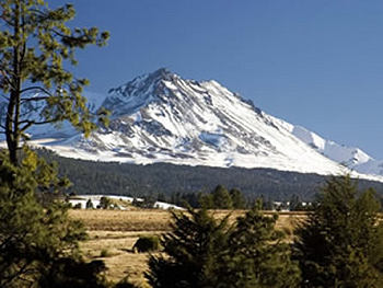
El Volcán Nevado de Toluca

El Volcán Nevado de Toluca

Background:

The Nevado de Toluca (also known as Chicnautécatl) is Mexico’s fourth highest peak, with a summit elevation of 4680 m (15,354 ft) above sea level. Located in central Mexico, southwest of the city of Toluca (the capital of the state of Mexico) and 80 km (50 miles) from Mexico City, the Nevado de Toluca is one of the most accessible volcanic peaks in the country. During the warmer months, regular vehicles can be driven very close to the volcano’s crater with its small lakes. During cooler months, when snow blankets the top portions of the mountain, the access road is popular with Mexico City families wanting to show their children what snow looks and feels like.

The area was granted National Park status in 1936, during the administration of President Lázaro Cárdenas, at a time when deforestation threatened to undermine the mountain’s ability to capture rainwater and be used as a water source for Mexico City and Toluca. (1936 was an important year in the history of environmental protection in Mexico because it was when the International Parks Commission was established which led to a series of protected areas–National Parks, Wildlife Areas and Forest Reserves–being established on either side of the Mexico-USA border).

The decree establishing the Nevado de Toluca National Park called for the expropriation of all the land around the volcano that was over 3000 m in elevation. The total area involved was about 536 sq. km. (207 square miles). While, for a variety of reasons, this expropriation was never fully implemented, deforestation of the volcano’s slopes was halted and tree-cutting banned.

In the succeeding decades, settlement expansion gradually ate away at the lower slopes with the result that the original National Park area now houses more than 5000 inhabitants in at least 16 distinct villages.

The newly designated Wildlife Reserve has a nucleus, centered on the crater, of 1.9 sq km, surrounded by a buffer zone of 51.7 sq. km.

A draft of the management plan for the Wildlife Reserve has been published by the National Commission for Protected Natural Areas (Comisión Nacional de Áreas Naturales Protegidas, CNANP) and made available for public consultation. The statuary 60-day consultation period began in mid-November.

The draft management plan [Map and plan both dated 5/11/2013] has met with considerable criticism in the popular press. The main issue is whether or not any such plan, however well intentioned, will be effectively enforced.

Several journalists have highlighted the very real danger that the new status will allow changes of land use in the former park that could lead to serious environmental degradation. The possible expansion of mineral extraction and of tourism within the Wildlife Reserve are of particular concern.

Nevado de Toluca Crater June 1986.

Nevado de Toluca Crater, June 1986. Photo: copyright Christopher Kessler (Wikimedia Commons)

Mining

In “Se tolerará la minería dentro del Nevado de Toluca“, Paris Martínez looks at the situation of several mining operations in the former park currently quarrying volcanic sand and gravel. Only one of these companies apparently had the requisite permit from the State of Mexico to quarry within the National Park area. The draft management plan allows all the quarries to continue operating for at least five years. Effectively, as Martínez points out, the change of status of the Nevado de Toluca means that mining operations that were operating illegally within the park are now “regularized”, for at least five years.

The main existing sand and gravel quarries are: El Atorón and Loma Alta in the municipality of Zinacantepec La Loba, El Capulín, Las Lágrimas (the only one with a state permit) and El Varal in Temascaltepec.

There are also reported to be many smaller illegal quarries extracting tepojal, a volcanic deposit similar to pumice, used in the construction industry. Unsupervised and unauthorized extraction is especially prevalent on the southern and eastern sides of the Wildlife Reserve.

Local residents say that quarrying, together with the construction of the access roads required to access the quarries, has resulted in serious environmental damage to the slopes of the volcano. Specifically, quarrying activities have led to:

  • deforestation
  • erosion, soil loss, degraded hydrology
  • loss of soil water absorbing capacity
  • particle emissions
  • loss of slope stability
  • visual pollution

The impacts of quarrying are not confined to the slopes of the volcano. The increased erosion of the lower slopes has led to local streams having to cope with a higher sediment load, reducing their capacity to carry the heavy rainy-season precipitation. This has led to flooding damage downstream in municipalities such as Tenango del Valle, Calimaya and Rayón.

The management plan appears to lack a clear pathway for the regulation or limitation of quarrying activities. At the same time, it calls for short-term remediation of areas that have been subject to soil degradation, but only for former mining areas that are not currently being exploited. It does nothing to reduce soil impacts in areas where quarrying is ongoing.

While the management plan does not discuss how or when the quarries might be closed, it does propose establishing workshops to develop “alternative productive activities” for the owners of small quarries, to provide them with an alternative source of income. However, the workshops are only mentioned as part of the long-term plan, ie to be introduced at some point at least 5 years down the road.

What’s more, only one alternative productive activity – public use, open-air recreation and tourism- is actually mentioned in the plan, alongside those activities that would provide products or services for tourism. Surely the final version of the plan should also suggest other viable options?

The plan calls for compensation for the owners of property where quarrying is halted, and who opt for alternative activities. However, this too is only mentioned as part of the longer term plan, so many landowners may well be tempted to start mining in the interim, in order to be able to claim compensation in a few years’ time!

Tourism

The decision to change the protection status of the Nevado de Toluca was based on a commissioned study that showed the area had potential for “intensive tourism” and “private infrastructure”. The study identified potential “tourism nuclei” or “sites for intensive tourism” where the construction of cabins was considered “feasible”. Following criticism and opposition that included almost 30,000 signatures on a change-org petition, the draft Management Plan does not use terms like “intensive tourism” and states that “tourism developments and ski runs may NOT be built in the area”, nor may subdivisions, hotels, golf courses or weekend homes.

The draft plan calls for “low-impact tourism” which is environmentally aware, defined as being suitable for activities such as hiking trails, camping and bird-watching. The plan allows for this form of tourism to be developed in most of the core area of the crater of the Nevado de Toluca as well as in a 3-square-kilometer section on the slopes of the volcano. The plan also allows existing settlements (whose area is not precisely defined) to develop tourism infrastructure; this could easily result in some short-term land-grabbing. Equally, precisely what counts as tourism infrastructure is not clearly defined.

Accepting that the National Park was never adequately patrolled or regulated, then if the new Wildlife Reserve Management Plan is tightly written and backed up by effective monitoring and the enforcement of regulations, then the volcano’s change of status may yet prove to be the best way to preserve the mountain’s unique character.

The draft plan is a valuable step forward, but Geo-Mexico hopes that the final Management Plan will address the many concerns raised in the press, to the benefit of both the volcano itself and its local residents.

Thanks to Arq. Ricardo Warman for first alerting us to the Nevado de Toluca’s change of protected status.

Related posts:
Angahuan, the nearest village to Paricutín Volcano in Michoacán, Mexico

 Other  Comments Off on Angahuan, the nearest village to Paricutín Volcano in Michoacán, Mexico
Mar 142013
 

Last month we recounted the events surrounding the birth of Paricutín Volcano in 1943 in the state of Michoacán in western Mexico:

Angahuan, the nearest village to Paricutín Volcano, is fascinating in its own right, quite apart from its connections to the volcano. The village has a lovely mid-sixteenth century church with many Moorish characteristics, as well as peculiar and distinctive house styles which make widespread use of local timber.

The original name was Andanhuan, which the Indians say the Spanish couldn’t manage to pronounce, hence its transformation to Angahuan. The Purépecha name meant “place on high where people stopped” or “place where the person on high (captain) stopped”.

The Spanish, complete with captain, arrived in 1527, under the command of Nuño Beltrán de Guzmán. One of the first missionaries here, Jacobo Daciano, ordered a Moorish stonemason who was with him, to stay in Angahuan and build a convent. The mason did a fine job—the church ceiling is truly magnificent—and Angahuan church is one of the very few in the country with such marked Moorish influences. The church is dedicated to Santiago (Saint James) and, as elsewhere in Mexico, he is shown astride his horse.

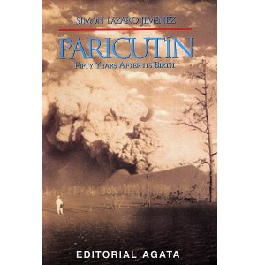
Across the small plaza is a wooden door richly carved in a series of panels which depict the story, or at least one version of it, of the eruption of Paricutín. Judging by one panel, the indigenous Purépecha artist-carpenter responsible for the door, Simón Lázaro Jiménez, clearly had a sense of humor about tourism. His design won first prize in a regional handicraft competition in 1981. The artist rejected the prize, copyrighted his unusual design, and used the finished handiwork as his own front door. He later penned a short book, Paricutín, 50 years after its birth, a vivid first-hand account of the fateful day when the volcano erupted and changed the lives of the local people for ever.

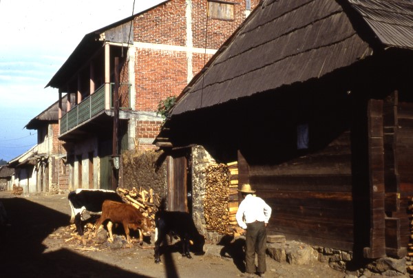
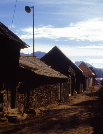
House types in Angahuan: traditional and modern. Photo: Tony Burton; all rights reserved

House types in Angahuan: traditional and modern. Photo: Tony Burton; all rights reserved

The distinctive house-types of Angahuan called trojes, are built of wooden beams with steep roofs. They are slowly giving way to modern monstrosities built with concrete blocks. The roofs of the traditional houses have either two or four slopes. Those with two slopes, one each side of the house, are called techos a dos aguas (literally “two waters”, “saddle roof” in English), those with four slopes techos a cuatro aguas (“four waters” or “hip roof”).

Angahuan: loudspeakers like this one relay village news.

Angahuan: loudspeakers like this one relay village news. Photo: Tony Burton; all rights reserved

Many small Mexican towns and villages rely on a village loudspeaker system for relaying all important events and news. Angahuan is no exception; look for the speakers mounted high over the plaza. Local announcements are in Purépecha, the local Indian language totally unintelligible to Spanish speakers. This is the only common language for the Indians in this area, since many of the older people do not speak Spanish. When necessary, their children will often translate for them. The Purépecha language is not closely linked to any other native Mexican language, but is apparently distantly related to that spoken by the Zuni of the USA and the Quechua and Aymara of South America.

Angahuan is one of the most accessible Purépecha villages in Mexico and well worth visiting, especially if your interests lie more in indigenous ways of life than in the splendid scenery and interesting geology of its surroundings.

This post is a lightly edited extract from my “Western Mexico: A Traveler’s Treasury” (Sombrero Books, 2013). “Western Mexico: A Traveler’s Treasury” is also available as either a Kindle edition or Kobo ebook.

Related posts:

A small village in Mexico won a 2004 UN Development Prize

 Excerpts from Geo-Mexico  Comments Off on A small village in Mexico won a 2004 UN Development Prize
Jun 142010
 

Every two years, the United Nations Development Programme (UNDP) awards the Equator prize (worth 30,000 dollars) to communities that have shown “outstanding achievement in the reduction of poverty through the conservation and sustainable use of biodiversity.”

One of the winners of the 2004 Equator prize was the indigenous community of Nuevo San Juan Parangaricutiro, in the state of Michoacán. More than 340 communities, from 65 countries, were nominated for consideration by the Equator Prize jury. The seven winning communities were honored at a prize-giving ceremony held in conjunction with an international Biological Diversity Conference in Kuala Lumpur, in Malaysia.

The success of Nuevo San Juan Parangaricutiro (hereafter referred to simply as Nuevo SJP) is all the more remarkable since their community did not even exist prior to 1944.

That is the year when all the founding residents of Nuevo (New) SJP fled their homes in “viejo” (Old) SJP as the sizeable town was overwhelmed by the lava erupting from Paricutín volcano. Paricutín first erupted, completely unexpectedly, in the middle of a farmer’s field, on February 20, 1943. It is a sobering thought that only 61 years to the day before the prize-giving, the volcano literally did not exist.

A remarkable account of those early days is given by Simón Lázaro Jiménez, who recounts in his book, Paricutín: 50 Years After Its Birth, his adventures as a young boy as he fled with his parents for safety as their small village of Angahuan was bombarded with red-hot rocks and ash. Don Simón’s is the only first-hand account of any substance written by a native P’urépecha speaker.

The volcano finally stopped erupting in 1952, but only after completely destroying the village of Parícutin (note that the position of the accent has changed over the years) and the town of viejo SJP. All that is left of the latter today are a few broken-down walls and parts of the huge, old church that did a brave job of withstanding the compelling force of the lava as it overran the rest of the town.

The people who fled the volcano (many initially refused to leave, but were escorted to safety by armed soldiers) stayed with friends and relatives and in makeshift camps before finding permanent accommodation, but later in 1944, founded Nuevo SJP after a presidential decree gave them land formerly belonging to the hacienda of Los Conejos.

The new town had to be completely planned from scratch. A gigantic church was built to commemorate the miraculous survival of part of the Old San Juan church which formed a partial barrier to the lava flow. Little by little a new community evolved, fostered in part by the high degree of cooperation required for building a new town and working virgin land.

In 1977, motivated by the abuse of local forest lands by private concession holders, the campesinos of Nuevo SJP organized their own union for farming and forestry workers. In 1981, they began their own forestry industry, and now collectively own and manage more than 11,000 hectares of pine, oak and fir forest. Over the years, their business activities have diversified to include a saw mill, a furniture factory (which has won export orders from Belgium and Ireland), a plant making wooden moldings for export to the USA, avocado and peach orchards, a packing plant which makes its own cases, a Christmas tree plantation, eco-tourism cabins and a resin distillation plant, as well as a store for the bulk purchase and resale of fertilizers. A water bottling plant, to bottle spring water, is one of the community’s latest proposals.

The community’s website gives details of all these activities and includes a link to a furniture catalog for those interested in buying direct. All the wood used is certified as “Smart Wood” (coming from well-managed forests) by the Forest Stewardship Council.

Community decisions in Nuevo SJP are made on behalf of the 8,000 or so residents by a General Assembly of the 1,300 Comuneros (community representatives), which has met at least once a month since 1983.

The Equator Prize was awarded because the forest policies adopted by the community “have provided a boost to local incomes while ensuring that the resource base upon which the community depends is sustained for future generations.” In addition, “the community’s successes have spread well beyond their origins as these novel conservation and business practices have been widely adopted by other indigenous communities in Mexico.”

Nuevo SJP may not be very old, or very large, but it certainly has a really big heart!

For a more detailed account of the history of the volcano, and of the considerable architectural attractions of the village of Angahuan, including its superb church, read chapter 35 of Western Mexico: A Traveler’s Treasury (Sombrero Books 2013).

Original article, as published on MexConnect

Mexico’s Volcanic Axis is discussed in chapter 2 of Geo-Mexico: the geography and dynamics of modern Mexico. The sustainable forestry project of San Juan Parangaricutiro is examined in chapter 15.