The ten states in Mexico with the lowest population density

 Other, Teaching ideas  Comments Off on The ten states in Mexico with the lowest population density
Feb 172011
 

In a previous post we looked at “The ten states in Mexico with the highest population density“. At the end of that post, we suggested that you try to guess which 10 states in Mexico have the lowest population density. In this post, we look at the answer!

Below is a table showing the 10 states in Mexico with the lowest population density.

RankStatePopulation density (people/sq.km)
1Baja California Sur8.6
2Durango13.2
3Chihuahua13.7
4Campeche14.3
5Sonora14.7
6Coahuila 18.1
7Zacatecas19.8
8Quintana Roo29.9
9Nayarit38.9
10Oaxaca40.6

You probably got many of the answers right, since several of the states in the table are among Mexico’s largest states in terms of area. In fact, Mexico’s five largest states (Chihuahua, Sonora, Coahuila, Durango and Oaxaca, are all on the list. However, there are some surprises. For example, both Nayarit and Campeche are smaller than the average Mexican state. Why might this be so? Large parts of each state currently have very few residents. Much of Nayarit is either mountainous terrain or swampy, coastal wetland. A large part of Campeche is sparsely peopled tropical evergreen forest (tropical rainforest).

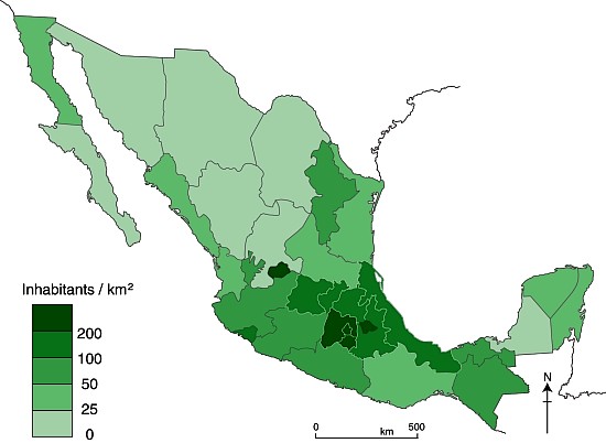
To conclude this brief look at population density, here is a map showing the population density of all Mexico’s 32 states. [For simplicity, we count the Federal District as a state.]

Population density map
Mexico’s population density in 2010

Several chapters of Geo-Mexico: the geography and dynamics of modern Mexico discuss population issues, including population distribution and population density. Buy your copy today to have a handy reference guide to all major aspects of Mexico’s geography!
The ten states in Mexico with the highest population density in 2010

 Other, Teaching ideas  Comments Off on The ten states in Mexico with the highest population density in 2010
Feb 102011
 

The table below shows the ten states in Mexico with the highest population density (people per square kilometer) in 2010.

Question:

  • Find a blank map of Mexico [click here for a printable pdf map of Mexico] and locate each of these ten states.
  • What do these ten states have in common?
  • Can you suggest a reason or reasons for any pattern you have found?

[the answer appears at the end of this post; no peeping until you have come up with an answer!]

RankStatePopulation density, 2010 (people/square km)
1Federal District5,936.8
2State of Mexico678.9
3Morelos364.2
4Tlaxcala292.6
5Aguascalientes211.0
6Guanajuato179.2
7Puebla168.5
8Querétaro156.2
9Hidalgo128.0
10Colima115.5

Did you suggest that these states are all small in area? If so, well done! The list of the ten states with the highest population density includes the eight smallest states in Mexico in terms of area, and all ten of the states are in Mexico’s twelve smallest states. The other two small  states, neither of which has a very high population density, are Nayarit and Tabasco; they are both smaller than either Puebla or Guanajuato.

Why should small states have higher population densities than large states? The main reason is because it is likely that a higher percentage of their area will be used for villages, towns and cities, and there will be less countryside (where population densities are usually very low) than is likely in large states. Of course, many other factors also play a part, including the location of resources (minerals, soil, water, biodiversity), the opportunities for employment and the relative wealth of the area (people may migrate from poorer areas to areas which they think are richer or offer more opportunities).

In a future post, we will take a look at which states in Mexico have the lowest population density.But, before we do, which states do YOU think will have the lowest population density? Choose your “top ten”, make a list or mark them on your map, and come back to Geo-Mexico next week to see if you are right…

How many Mexicans are there? The preliminary figures from Mexico’s 2010 national population census

 Updates to Geo-Mexico  Comments Off on How many Mexicans are there? The preliminary figures from Mexico’s 2010 national population census
Nov 262010
 

The National Statistics Institute (INEGI) has released the preliminary figures from Mexico’s 2010 national population census. INEGI claims that its 190,000 census workers were able to visit 98.4% of all homes in the country. The lowest response rates were 91.3% and 91.5% respectively in the troubled northern border states of Tamaulipas and Chihuahua.

Update: 2020 – Total population is about 126 million.

The highlights of the preliminary results

The preliminary results of the 2010 census reveal some interesting changes.

First, Mexico’s total population in 2010 is  112,322,757. This is almost 4 million higher than INEGI’s pre-census estimates. The population total means that Mexico remains the world’s 11th most populous country.

Mexico has now become a markedly urban society. Whereas a hundred years ago, in 1910, 71.3% of the then population of 15.2 millions lived in rural areas (defined as municipalities with fewer than 2,500 inhabitants), in 2010, 62.6% of all Mexicans live in one of the country’s 56 largest metropolitan areas (as defined by INEGI). The largest single metropolitan area is the Mexico City Metropolitan Area (which extends into the State of Mexico) with a population of 20.1 million.

The density of population has changed over the last century as well. In 1910, the overall density of population was 8 persons/square kilometer. In 2010, the density of population was 57 persons/square kilometer (with Mexico D.F. having the highest value in Mexico of 5,937 inhabitants/square kilometer!).

Emigration in search of work, and a declining maternal mortality rate have completely changed Mexico’s male/female ratio. Whereas in 1910, there were 102.7 males for every 100 females, in 2010 there are  95.5 males for every 100 females.

As more figures are released in coming months, we will offer further insights into the changing geography of Mexico.

In the meantime, for a comprehensive summary of Mexico’s geography, including several chapters about Mexico’s population, ask Santa Claus, a friend or family member to give you a copy of Geo-Mexico: the geography and dynamics of modern Mexico. What better seasonal gift could there possibly be?

Is Mexico’s population evenly distributed?

 Excerpts from Geo-Mexico  Comments Off on Is Mexico’s population evenly distributed?
May 222010
 

No! Mexico’s population (mid-2010 estimate: 108,396,211) is not evenly distributed. Parts of central Mexico are very densely populated while there are relatively few people in the wide open spaces in northern Mexico. This is perhaps one of the most important features of Mexico’s human geography.

The Federal District and adjoining State of Mexico make up just over 1% of Mexico’s area, but house over 22% of the population for a density of 950 persons per km2.  A central band, including Mexico City, encircled by Guadalajara, Aguascalientes, Xalapa, Veracruz, Puebla, Cuernavaca and Morelia covers only 10% of the land but contains over half of all Mexicans and has a density higher than that of northeastern USA (between Washington and Boston), UK, Germany or Italy.

The other 90% of Mexico has 50 million people, more than any other Latin American country except Brazil. Population densities in those areas are low.

In conclusion, some areas of Mexico are indeed crowded, but most of Mexico is not.

See this earlier post for a visually dramatic cartogram depicting Mexico’s population distribution.

Mexico’s population distribution and population density are analyzed in chapter 8 of Geo-Mexico: the geography and dynamics of modern Mexico.