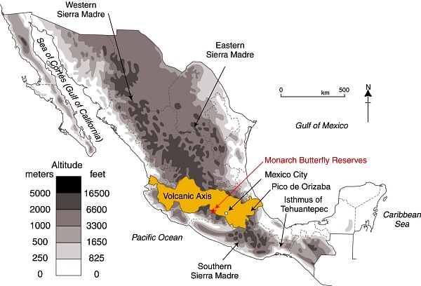
Describing somewhere in Mexico as being “located in the Sierra Madre mountains” may conjure up images of high, possibly snow-capped peaks and rugged scenery, but does very little to pin down the location. Mexico has several Sierras Madre (literal translation: Mother Ranges). The three main Sierra Madre regions in Mexico are the Western Sierra Madre, Eastern Sierra Madre and Southern Sierra Madre (see map).
The Western Sierra Madre (Sierra Madre Occidental) is the youngest, highest and most viciously dissected of the three. This region includes the scenically amazing Copper Canyon region we have described in many previous posts, including:
- The seven main canyons in the Copper Canyon region
- How were the canyons in the Copper Canyon region formed?
- Mexico’s Copper Canyon train is one of the world’s great railway trips

Location of Volcanic Axis and Monarch Butterfly reserves. Basemap: Figure 3.1 of Geo-Mexico; all rights reserved.
The Western Sierra Madre extends only as far south as the states of Nayarit and Jalisco.
Its counterpart on the eastern side of the country is the Eastern Sierra Madre (Sierra Madre Oriental) which is older, lower and less rugged. Between these two major mountain ranges are mid-elevation basins and plains.
At the southern end of both the Western Sierra Madre and the Eastern Sierra Madre is the Volcanic Axis.
The Southern Sierra Madre (Sierra Madre del Sur) lies south of the Volcanic Axis, largely in the state of Oaxaca.
The details of Mexico’s physiographic regions are complex, but the basic relief pattern of these three Sierra Madre regions, separated by the Volcanic Axis and mid-elevation basins and plains, is fairly simple. It is therefore disappointing when we read references to the Sierra Madre regions that are geographically inaccurate.
The Monarch Butterfly reserves, for instance, are regularly described as being in the Sierra Madre, or the Western Sierra Madre, even though they are located hundreds of kilometers away from the Western Sierra Madre, on the southern edge of the Volcanic Axis (see map). In the original National Geographic article about the “discovery” of the Monarch Butterflies’ overwintering sites (August 1976), the location of the butterflies was deliberately left vague (to prevent human-induced disruption of the sites), so that article can readily be excused for mislocating the sites as being in “Mexico’s Sierra Madre”. (The tiny map that accompanied that article also shifted the Monarch’s wintering areas well away from their real position.)
Despite the efforts of the National Geographic, it was not long before journalists published articles giving the precise locations of the sites, and visitors started to flock to see this marvel of nature. The establishment of reserves has now brought a measure of sanity and control to access and most visitors now behave respectfully.
One of the latest in the long line of journals and magazines to erroneously refer to the site of the Monarch reserves as “in the remote Sierra Madre mountains” (but lacking the original excuse of the National Geographic) is the Canadian Geographic in its December 2013 Annual Wildlife Issue. The general tone of the article is helpful, and it rightly emphasizes the need to protect habitat along the entire migration route between Canada and Mexico, so why mar the overall quality by making such a basic error of Mexican geography? Let’s help educate readers by making it clear that the Monarch Butterfly reserves are not in any Sierra Madre, but are in the Volcanic Axis!
Sorry, the comment form is closed at this time.