As we discussed in this earlier post, historical analysis combined with greater climatological understanding shows that many of the worst droughts and floods in Mexico have been associated with either El Niño Southern Oscillation (ENSO) events or with the related Pacific-North American Oscillation. Perhaps 65% of the variability of Mexican climate results from changes in these large-scale circulations.
The World Meteorological Organization (WMO) says the 2015-2016 ENSO is expected to be one of the three most powerful ENSO events since 1950 with effects that will last for up to eight months.
What will this winter’s El Niño bring?
- slightly higher ocean water temperature off west coast; some fish species may migrate northwards
- some winter rain in north-west
- increased winter storms, and cooler temperatures, along east coast; risk of flooding, mudslides
- reduced summer rainfall in Mexico’s central highlands; risk of drought and lower crop yields
This winter, according to the Center for Scientific Investigation and Higher Education of Ensenada (CICESE), the Baja California Peninsula is likely to receive more rain than usual during this year’s very strong ENSO (El Niño) event.
The distribution of fish species is likely to change as the ocean temperatures are higher than usual, resulting in the migration of some species, leaving fewer fish off the coast of Baja California, one of the world’s most important commercial and sports fishing zones. Sardine fishermen may have a difficult season, incurring greater costs as they try to locate viable schools of fish.
A NASA climatologist predicts that California (USA) will be on the receiving end of more winter storms (January-March), and heavier rain, than usual. This increases the risk of hazardous mudslides in some coastal communities. It could also mean more mosquitoes, and an increased chance of contracting dengue fever or chikungunya.
What is the longer term outlook?
The first map shows likely precipitation anomalies for early next year (Spring). Areas shaded brown are areas expected to receive less rainfall than normal. Areas shaded light blue through green are predicted to get more rain than usual.
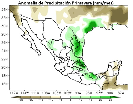
Spring precipitation anomalies in a strong El Niño year. Source: CNA
The second map shows summer precipitation anomalies. A significant reduction in rainfall is expected across most of central Mexico, though some areas in southern Mexico will likely get more rainfall than normal.
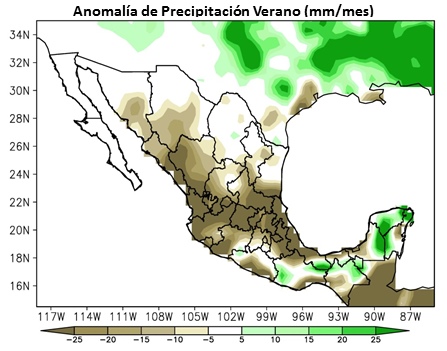
Summer precipitation anomalies in a strong El Niño year. Source: CNA
We end with one piece of good news for our more active readers. Previous El Niño events have brought great surfing to the west coast of Mexico, so make your travel and hotel plans as soon as possible.
Related posts:
4 Responses to “How will this year’s strong El Niño affect Mexico?”
Sorry, the comment form is closed at this time.
Thanks for the El Niño update. Arrived in the Yucatan two weeks ago and locals tell us this has been a very rainy November so far. It hasn’t bothered our travel plans at all, but we carry an umbrella most days.
Planning a trip to mazatalin Mexico in February, can anyone tell me if it’s been a rainy winter
Planning a trip to cancun in November 2016, can anyone tell me if that is good or bad with the weather?
November should be fine – hurricane season is usually over by then, and dry season underway; enjoy!