Expected impact on Mexico of global climate change

 Other  Comments Off on Expected impact on Mexico of global climate change
Dec 222010
 

The overall temperature of the earth is increasing faster now than it has for many millennia. According to a 2007 Intergovernmental Panel on Climate Change (IPCC) paper, the global surface temperature is expected to increase by 1.1 to 6.4 degrees C (2.0 to 11.5 degrees F) during the 21st century. According to the models, global warming will be most pronounced in the Arctic resulting in the melting of glaciers, permafrost and sea ice. Warming is expected to be less pronounced in Antarctic areas.
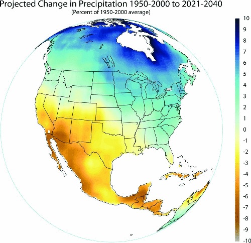
Precipitation change in Mexico, 1950-2000 and 2021-2040

Precipitation change in Mexico, from 1950-2000 to 2021-2040. Image/data: Gabriel Vecchi, Geophysical Fluid Dynamics Laboratory, National Oceanic and Atmospheric Administration.

Given the high average altitude of Mexico, the temperature changes and raising sea level should have less impact on Mexico than most other countries. Still, low laying areas of Mexico will be affected significantly.

Global warming will have profound impacts on the world’s climate. The most severe impacts on Mexico, and perhaps the whole Earth, could very well result more from climate change than global warming per se. In general, the affects will involve significant changes in average annual amounts of precipitation as well as huge year to year variability.

Mexico will experience significantly more severe droughts, floods, and storms including hurricanes. This trend has already started. In the 25 years between 1960 and 1985, Mexico experienced one category five hurricane – Beulah in 1967. In the 25 years since 1985, four category five hurricanes hit Mexico: Gilbert – 1988, Mitch – 1998, Wilma – 2005, and Dean – 2007. Fortunately, no category five hurricanes struck Mexico in 2009 or 2010. Are we due in 2011?

In general, precipitation in Mexico is expected to decline significantly in the next several decades. As you can see on the map, Western Mexico and the Yucatan will get 5% to 8% less rain. This is particularly important to Northwestern Mexico which is the most arid part of the country. Unfortunately, with the expected large increase in year to year variability, this part of Mexico is expected to suffer many very serious droughts. Obviously, less rainfall and greater variability will have gigantic impacts on Mexican agriculture, especially in the drier western areas.
Dec 182010
 

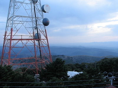
One of Mexico’s best kept travel secrets for people driving their own vehicle is the multitude of road signs all beginning with the word “microondas” (literally “microwaves”). Even visitors with good Spanish and a bilingual dictionary in their glove compartment may puzzle over the meaning of this frequently occurring sign, which invariably seems to lead onto a cobblestone track going, so far as one can tell, absolutely nowhere! There is no distant church tower, no sign of habitation, just a radio mast on the distant skyline. And that (rather than microwave ovens) is precisely what the sign refers to: a short-wave communications post!

One of the numerous benefits for the geographer is that virtually any microondas station offers a short, usually interesting side-trip, ideal for a brief respite from the demands of high speed highway driving. The well maintained, cobblestone tracks that provide access to the communications towers serve not only engineers, but also enterprising tourists. The access roads may follow devious routes but they eventually reach the gates of a fenced enclosure, invariably situated on the highest point for several miles in any direction. While there is no guarantee of an uninterrupted view, most microondas stations afford tremendous vistas over the surrounding countryside.

Microondas at top of Cerro de los Caballos. Photo: Gabriel Chaparro Tre….

View from the Microondas atop Cerro de los Caballos. Photo: Gabriel Chaparro Tre….

Very few vehicles use these excellent side roads, so they are usually safe and convenient places to stop, take a rest, stretch your legs and enjoy a picnic. As the tracks wind upwards, they often traverse successive vegetation zones, going from oak woodland up into pine forest if the mountain is high enough, for instance. This provides botanists and birders a range of habitats and transition zones worth exploring. Of course, some microondas sit on top of small mounds surrounded by a seemingly limitless flat and monotonous plain, home only to an infinite number of cacti. But others, the jewels of their kind, are in the midst of tropical rainforest looking out over canyons where spider monkeys can be seen leaping from branch to branch.

In the volcanic central areas of Mexico, microondas stations are commonly perched on crater rims, making many volcanoes fall in the “drive-in” category, including the Volcán Nevado de Toluca (Xinantécatl).  Full descriptions of the scenic wonders to be encountered on drives up, for example, Ceboruco volcano or Tequila volcano (the former in Nayarit state, the latter in Jalisco) merit a book unto themselves. To anyone who has never seen the legacies of past vulcanicity at close quarters, what more awesome and eye-opening introduction could there possibly be?

Needless to say, though you’re never far from the highway, you mustn’t expect to find any tourist amenities at microondas, not even “microwaved” fast-food. But don’t let that put you off visiting Mexican-style microwaves.

So, next time you spy “microondas” on a road sign (or, if you’re reading this in the depths of northern winter, the next time you press a button on your microwave!), remember – a short detour along one of Mexico’s best-kept travel secrets might well lead you to discover your own favorite stopping place. Someday, somewhere, someone should produce a comprehensive guide to the microondas of Mexico…

Mexico’s volcanic landscapes are discussed in chapters 2 and 3 of Geo-Mexico: the geography and dynamics of modern Mexico. Buy a copy as a seasonal gift today!

The geography of renewable energy from wind power in Mexico

 Other  Comments Off on The geography of renewable energy from wind power in Mexico
Dec 162010
 

According to the World Association of Wind Power, Mexico grew its wind power sector faster than any other country during 2009, and now has more than 500MW of installed windpower capacity.

Mexico’s goal is to have an installed capacity of 2,500 MW of wind energy by 2012, and to have 26% of the nation’s installed capacity coming from clean energy sources (solar, geothermal, wind, nuclear and large-scale HEP). The Federal Electricity Commission, responsible for the national power grid, is installing two “wind corridors” in Oaxaca to connect several different windpower plants into the grid.

Mexico’s Energy Secretariat recently announced the publication of a new resource of interest to planners and geographers. The Atlas of Wind and Solar power potential is designed to inform investors of the necessary meteorological and climatic background prior to taking significant investment decisions.

According to the Atlas, Mexico’s wind potential is estimated at 71,000 MW. This figure comfortably exceeds the nation’s current installed capacity for all forms of power of 51,000 MW.

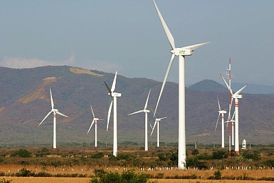
The most important single wind-power region in Mexico, and also one of the most important at the global scale is the Isthmus of Tehuantepec, the narrow belt of relatively low-lying land that links the Gulf coast (straddling the Veracruz-Tabasco state boundary) to the Pacific coast in the state of Oaxaca.

La Ventosa wind farm, Oaxaca

La Ventosa wind farm, Oaxaca

Several major wind farms have already been developed in the La Venta section of the Isthmus. Others are being constructed or on the drawing board. For example, Grupo Bimbo (which, with the acquisition of Sara Lee, has become the world’s largest bread- and pastry-maker) announced it is building a wind farm in association with Desarrollos Eólicos Mexicanos (Demex), a subsidiary of Spanish renewable energy firm Renovalia Energy. The “Piedra Larga” wind farm is under construction in Unión Hidalgo, Oaxaca. Costing $200 million, it will have an installed capacity of 90 MW when the first phase is complete, rising to 227 MW when the project is complete. This is sufficient energy to power all Bimbo’s producing and distribution needs in Mexico during the next 18 years at least. The first power will be generated early next year.

Two mining companies are also installing wind farms in Oaxaca, each with an installed capacity of 300MW.

Elsewhere, in Baja California, California-based Cannon Power Group plans is constructing a 1,000MW wind farm in Baja California. The 500 turbines of the 1-billion-dollar Aubanel Wind Project will be located southeast of the town of La Rumorosa, in the mountains between Tijuana and Mexicali. The turbines will supply power to both the USA and Mexico and are a separate project to the 1000MW wind farm planned by Energía Sierra Juárez, a subsidiary of Sempra, for an area north of La Rumorosa.

Currently, Mexico is developing wind power much more quickly than solar power, but this may change in the future, given that much of the country receives between 5 and 6kw/hr/square meter/day in solar energy, which is considerably more than most of the European countries which are now undertaking solar power development.

Related earlier post:

Energy is analyzed in chapter 16 of Geo-Mexico: the geography and dynamics of modern Mexico. and concepts of sustainability are explored in chapters 19 and 30.  Buy your copy today, so you have this handy reference guide to all aspects of Mexico’s geography available whenever you need it.

How much longer will Mexico be an exporter of oil?

 Other, Teaching ideas  Comments Off on How much longer will Mexico be an exporter of oil?
Dec 152010
 

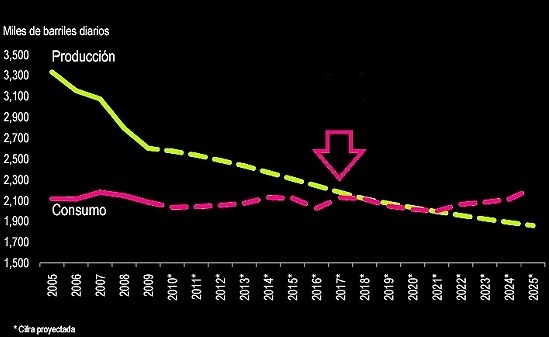
This interesting graph comes from a report published earlier this year by the Mexican Institute for Competitiveness (Instituto Mexicano para la Competitividad, IMCO). The purple line shows Mexico’s oil consumption in thousands of barrels/day from 2005 to 2009, with predicted values for the period 2010 to 2025. The yellow line shows Mexico’s oil production for the same period.

Graph of Mexico's oil production and consumption

Mexico's oil production (yellow) and consumption (purple), 2005-2025. Graph: IMCO.

Discussion questions:

  • In which year is Mexico’s consumption of oil predicted to equal its production?
  • What effects is this likely to have on Mexico’s economy?
  • What factors might cause this date to occur earlier than predicted?
  • What factors might cause this date to occur later than predicted?

A national map and summary of the methodology behind these rankings are provided in an earlier post:

For full details of the study:

Mexico’s economy and workforce are analyzed in chapters 14 to 20 of Geo-Mexico: the geography and dynamics of modern Mexico. Ask your library to buy a copy of this handy reference guide to all aspects of Mexico’s geography today! Better yet, order your own copy, which will still arrive in time for Christmas…

Updates on the geography of Mexico City

 Mexico's geography in the Press  Comments Off on Updates on the geography of Mexico City
Dec 132010
 

We start this periodic round-ups of news items related to the geography of Mexico City with an update on Mexico City’s population. The preliminary results of the 2010 census show that the Mexico City Metropolitan Area (MCMA) has a population of 20,137,152. This includes the Federal District with its 8,873,017 inhabitants. The Federal District has grown only slowly since 2000, but the State of Mexico, much of which is included in the MCMA, grew five times as quickly (its growth was 1.59%/yr between 2000 and 2010).

New electric Nissan taxis

Several hundred all-electric taxis will soon be circulating in Mexico City. In the second half of 2011, 500 Nissan “Leaf”s (Leading, Environmentally friendly, Affordable, Family cars) will be added to the city’s massive taxi fleet. When fully charged, the Leaf has a range of up to 160km, with zero emissions of CO2. Nissan is reported to be installing recharging stations in locations such as supermarket and restaurant parking lots. The Leaf is expected to go on sale to the public in 2012.

Fines for using non-biodegradable plastic bags

Mexico City authorities have dropped the possibility of  jail time, but kept stiff fines for anyone using plastic bags that are not bio-degradable. Store owners and employees are no longer allowed to give away non-biodegradable plastic bags. Repeat offenders will face fines of up to 9,250 dollars.

Levies on excess garbage

Watch out big business! Mexico City authorities have announced a crack-down on the solid wastes generated by large commercial enterprises, including shopping centers. About 2,000 places will be inspected; they currently pay about 1.2 million dollars (15 million pesos) a year in excess waste fees, but the city believes many are abusing the system, which is based on self-reporting. Mexico City’s solid waste regulations classify anyone disposing of more than 50 kg a day as a “high volume waste generator.” Anyone in this category must pay for every kilogram of waste beyond the basic 50 kilos. The current rates (per kilogram) are 0.50 pesos for construction materials, 1.00 pesos for urban waste, 1.83 pesos for plant-related waste and 2.20 pesos for wastes requiring special handling. Businesses will be audited by city inspectors to ensure that the amount of waste they produce matches what they officially report, and fines will be levied for non-compliance.

The geography of Mexico City is analyzed in chapters 21, 22 and 23 of  Geo-Mexico: the geography and dynamics of modern Mexico. Ask your library to buy a copy of this handy reference guide to all aspects of Mexico’s geography today! Better yet, order your own copy…

Dec 122010
 

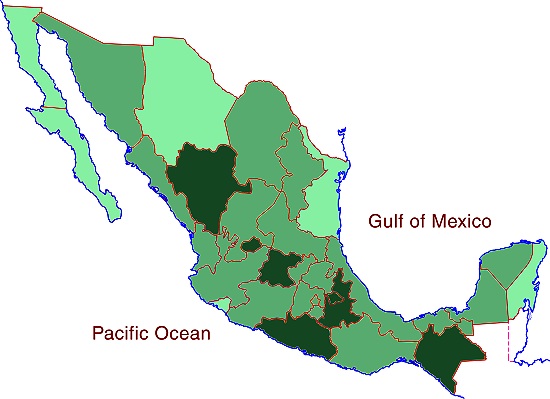
The map below shows the average number of inhabitants per household (“household size”) for each of Mexico’s states.

The national average household size is 3.9 persons. The middle band on the map shows those states with household size between 3.7 and 4.0 inclusive. The darkest shade shows states with a household size of 4.1 or greater; the lightest shade shows those with a household size of 3.6 or smaller.

Average household size in Mexico, 2010

Average household size in Mexico, 2010. Cartography: Tony Burton; all rights reserved.

Discussion questions:

  • Compare this map with the maps of:
  1. potable water,
  2. GDP/person
  3. infant mortality
  • Discuss the possible reasons for any connections you note between household size, potable water, GDP/person and infant mortality.
  • What other factors might also affect household sizes?
  • What are the drawbacks to using any of these measures (household size, potable water, GDP/person, infant mortality) on their own as a development indicator?

Development indices of various kinds are discussed in chapters 29 and 30 of Geo-Mexico: the geography and dynamics of modern Mexico. Ask your local library to purchase a copy today!

Dec 102010
 

Mexico’s economy, the world’s 11th largest, is growing rapidly and predicted by many analysts to become the world’s fifth largest by 2050. It is not, therefore, surprising that, according to a recent report on key emerging markets from Spanish bank BBVA, investments in emerging markets are assuming more and more importance. However, the all-encompassing term “emerging market” covers a multitude of countries whose individual economies are incredibly diverse. It includes not only major economies such as those of China, India and Mexico, but also a host of tiny island states such as Grenada, Vanuatu and the Seychelles.

BRICs or EAGLE

BRICs or EAGLE?

Economists have suggested various sub-groupings of emerging markets. One of the most commonly used in geography is BRIC, an acronym formed from the initial letters of Brazil, Russia, India and China. The term BRIC was first coined by  Jim O’Neill in a 2001 paper entitled “The World Needs Better Economic BRICs”. The concept of BRICs has become outdated as the four countries’ economies have diverged over the past decade. Any term comprised of country names will inevitably date fairly quickly, and become much less useful.

Now, BBVA has proposed the use of the term EAGLE to cover the world’s Emerging and Growth-Leading Economies. The member states of this exclusive EAGLEs club are:

  • China
  • India
  • Brazil
  • Russia
  • South Korea
  • Indonesia
  • Mexico
  • Turkey
  • Eqypt
  • Taiwan

These ten countries are each expected to contribute more to global economic growth than the average of G7 members. Combined, the ten EAGLEs are  expected to account for 50% of all global growth in the next 10 years.

A further eleven countries—Nigeria, Poland, South Africa, Thailand, Colombia, Vietnam, Bangladesh, Malaysia, Argentina, Peru and the Philippines—are identified by BBVA as having the potential to join the EAGLEs if their economies grow more than expected.

The BRIC is dead! The EAGLEs are rising! Long live the EAGLEs!

Mexico’s economy and workforce are analyzed in chapters 14 to 20 of Geo-Mexico: the geography and dynamics of modern Mexico. Ask your library to buy a copy of this handy reference guide to all aspects of Mexico’s geography today! Better yet, order your own copy…

Mexico’s major metropolitan areas and cities, 2010

 Updates to Geo-Mexico  Comments Off on Mexico’s major metropolitan areas and cities, 2010
Dec 092010
 

The table shows the population figures for Mexico’s 14 largest metropolitan areas, according to the preliminary results of the 2010 census. Mexico currently has 11 metropolitan areas with a population in excess of one million inhabitants. Three other cities have over 900,000 inhabitants, and look set to join the million-plus club within the next few years. A further seven cities—Saltillo, Chihuahua, Acapulco, Morelia, Cuernavaca,Tampico and Veracruz—have populations between 800,000 and 900,000.

1Mexico City (Valley of Mexico)20,137,152
2Guadalajara4,434,252
3Monterrey4,080,329
4Puebla-Tlaxcala2,668,347
5Toluca1,846,602
6Tijuana1,751,302
7León1,609,717
8Cd. Juárez1,328,017
9Torreón-Gómez Palacio (La Laguna)1, 215,993
10Querétaro1,097,028
11San Luis Potosí1,040,822
12Mérida970,495
13Mexicali936,145
14Aguascalientes932,298

Chapters 21 and 22 of Geo-Mexico: the geography and dynamics of modern Mexico analyze Mexico’s 500-year transition to an urban society and the internal geography of Mexico’s cities. Chapter 23 looks at urban issues, problems and trends. To preview more parts of the book, click here and use amazon.com’s “Look Inside” feature; buy your copy today!

Map of population change in Mexico, 2000-2010

 Updates to Geo-Mexico  Comments Off on Map of population change in Mexico, 2000-2010
Dec 072010
 

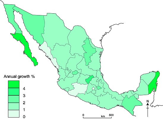
The publication of the preliminary results from this year’s population census has allowed us to update our map of Mexico’s recent population change (Figure 8.3 of Geo-Mexico: the geography and dynamics of modern Mexico). We are delighted to bring you what may be the first map to be published anywhere in the world of Mexico’s population change over the past decade:

Annual % population change in Mexico, 2000-2010

Annual % population change in Mexico, 2000-2010. Cartography: Tony Burton, all rights reserved.

The pattern on this map for 2000-2010 shows that population change over this period has been broadly similar to that for the period 1970-2005 (Figure 8.3 of Geo-Mexico: the geography and dynamics of modern Mexico). Mexico’s total population has grown by an average of 1.52%/yr over the past decade.

Things to note:

The fastest growth rates are in Baja California Sur and Quintana Roo, both states where tourism continues to develop rapidly and attract more migrants.

The slowest rates are in the Federal District (Mexico D.F.), Michoacán and Sinaloa, all of which have rates of less than 1%/yr. Michoacán’s low rate of increase is an anomaly, given the state’s high birth rate, and must be due to out-migration.

In central Mexico, the state of Querétaro stands out as being the most dynamic state in population terms, registering a growth of more than 3%/yr over the last decade.

Discussion Question: How does this map compare to the map of GDP/person?

Several chapters of Geo-Mexico: the geography and dynamics of modern Mexico discuss population issues, including population growth, distribution and density. Buy your copy today to have a handy reference guide to all major aspects of Mexico’s geography!

Dec 062010
 

Cancún is Mexico’s premier tourist destination, attracting more than 3 million visitors a year. A recent Associated Press report by Mark Stevenson highlights the problems faced by the resort due to the erosion of its beaches.

Cancún was developed on formerly uninhabited barrier islands on Mexico’s Caribbean coast. The islands were low-lying sand bars, held together by beach vines and the dense, interlocking roots of coastal mangroves. Hurricanes periodically swept over these small islands blowing loose sand towards the beaches on the mainland. Despite the occasional hurricane, the sandbars survived more or less unscathed until construction of Cancún, Mexico’s first purpose-built tourist resort, began in 1970.

As Cancún has grown, so the damage from hurricanes has become more serious. Category 4 Wilma in 2005 was especially destructive.

Cancún beach erosion

Cancún beach erosion. Photo: Dario Lopez-Mills/AP

Why has hurricane damage increased since 1970? Several factors are thought to play in a part in causing the increased rate of erosion of Cancún’s beaches in recent years:

  • hotels have been built too close to the shore, and too many are high-rise buildings. High-rise hotels deflect some of the wind downwards towards the ground. These wind eddies can stir up any dry surface sand in a process known as deflation.
  • hotels are too heavy. The sheer weight of high-rise hotels compacts the largely unconsolidated sediments beneath them, rendering the sediments less able to store or absorb excess water, and more liable to subsidence and structural problems. Extra weight also increases the load on slopes and leads to a higher incidence of slope failure.
  • coastal mangroves have been destroyed, removing their ability to protect the shoreline during storm events.
  • most beaches have been stripped of their original vegetation. The original beaches were protected by various adventitious vines which were quick to colonize bare sand. They would simultaneously help hold the sand in place, protecting it from wind action, and gradually add to the organic content of beaches to a point where they could support other, larger plants. Native vegetation has been mercilessly eradicated from Cancún’s beaches to create the tourism “ideal” of uninterrupted swathes of white sand.

It also appears that hurricanes and other tropical storms have become more frequent in recent decades, perhaps as a consequence of global climate change. The situation has also been exacerbated by the gradually rising sea level. Sea level on this coast is rising at about 2.2 mm/y.

Why have some of the efforts made to mitigate the beach erosion only made the situation even worse?

Following strong hurricanes (such as Wilma in 2005) Cancún has lost most of its beaches. The first attempt at beach restoration in 2006 cost 19 million dollars. In 2009, an even costlier (70 million dollar) beach restoration was carried out, using sand dredged from offshore. In one sense, the project was a resounding success. A new beach up to 60 meters wide, was created along some 10 km of coastline.

However, this new beach came at a considerable ecological cost. The pumping of sand from offshore disturbed the seafloor and damaged sealife, including populations of octupus and sea cucumbers. Fine sediments raised by the pumping traveled in suspension to nearby coral reefs, where it also had deleterious impacts.

In addition, the new beach is already being eroded away (some estimates are that up to 8% of the new sand has already been washed or blown away), so presumably if Cancún’s beaches are to be maintained in the future, beach restoration will have to become a regular event.

One hotel erected a breakwater or groyne on its beach to retain all the sand being carried along the coast by the process of longshore drift. The Associate Press article ends with a wonderful story of how the beach in front of this particular hotel was cordoned off by marines last year on the grounds that it was stolen property.

Link to 2013 news article: A fortune made of sand: How climate change is destroying Cancun

Tourism is one of Mexico’s major sources of revenue. But tourism, especially high-rise mass tourism such as that characterized by Cancún, comes with a hefty price tag. Policy-makers need to decide whether this price tag, which will only rise further in the future as we continue to damage our natural environment, is really one that is worth the cost.

Chapter 19 of Geo-Mexico: the geography and dynamics of modern Mexico looks in much more detail at Mexico’s purpose-built resorts as well as many other  aspects of tourism, resorts and hotels  in Mexico. Chapter 30 focuses on environmental issues and trends. Buy your copy today!

How good were the 2010 hurricane predictions?

 Other  Comments Off on How good were the 2010 hurricane predictions?
Dec 042010
 

In an earlier post – How many hurricanes are likely in the 2010 Atlantic hurricane season? – we reported on the predictions for this year’s Atlantic/Caribbean hurricane season

How close to reality did those predictions turn out to be?

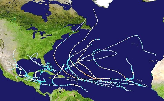
The predictions were for 8 tropical storms, 5 moderate hurricanes (1 or 2 on the Saffir-Simpson scale), and 5 severe hurricanes (3, 4 or 5 on the Saffir-Simpson scale). At the end of the season (30 November 2010), there had been 7 tropical storms, 7 moderate hurricanes and 5 major hurricanes. In total, these storms caused 259 deaths directly, and a further 23 indirectly, with total property damage estimated at US$11.4 billion. (Note that not all of these hurricanes affected Mexico).

Atlantic Hurricane tracks, 2010

Atlantic hurricane tracks, 2010. Created by Cyclonebiskit using Wikipedia: WikiProject Tropical cyclones/Tracks. Author: Cyclonebiskit and Syntheticalconnections

So, all in all, the predictions made before the hurricane season started were pretty close to the mark, and this hurricane season was indeed one of the most active on record.

Previous hurricane-related posts include:

Hurricanes and other climatological phenomena are analyzed in chapters 4 and 7 of Geo-Mexico: the geography and dynamics of modern Mexico. Buy your copy today, so you have a handy reference guide available whenever you need it.

The 2010 United Nations Climate Change Conference in Cancún, Mexico

 Mexico's geography in the Press  Comments Off on The 2010 United Nations Climate Change Conference in Cancún, Mexico
Dec 012010
 

The 2010 United Nations Climate Change Conference is now underway in Cancún, Mexico. It began 29 November and closes 10 December 2010. One of the objectives that Mexico hopes to achieve is the setting up of a Global Green Fund to help nations adversely affected by climate change to finance projects of mitigation and adaptation.

IPCC CancunAt the 2009 round of talks, in Copenhagen, Denmark, the countries present failed to agree any significant actions, choosing instead to sign a non-binding agreement and “agree to disagree”.

Prior to the Cancún meeting, four preparatory rounds of negotiations have already been held in 2010. The first three rounds were in Bonn, Germany:  April 9-11;  June 1 – 11; and August 2 – 6. After the August meeting, UN Secretary-General Ban Ki-Moon publicly doubted that member states would reach any new agreement on global warming at the Cancún Conference.

The fourth preparatory round of talks, held in Tianjin, China, also made minimal progress as the USA and China could not agree on key issues. However, following that meeting, Christiana Figueres, Executive Secretary of the UN Framework Convention on Climate Change (UNFCCC), said, “This week has got us closer to a structured set of decisions that can be agreed in Cancún … This is the greatest societal and economic transformation that the world has ever seen.” Other commentators have also spoken of a positive spirit of negotiation, which will hopefully pave the way for an agreement to be reached in Cancún.

We will have to wait until the conclusion of the Cancún Conference before assessing its success or lack thereof, but let us hope that the delegates can this year come to some meaningful, and binding decisions.

Previous posts about global warming:

Mexico’s environmental trends and issues are examined in chapter 30 of Geo-Mexico: the geography and dynamics of modern Mexico. Ask your library to buy a copy of this handy reference guide to all aspects of Mexico’s geography today! Better yet, purchase your own copy…