OtherComments Off on Basalt columns and prisms can be seen in various places in Mexico
Oct252016
Basalt is a dark, fine-grained, basic (low silica) igneous rock, often extruded as molten lava from volcanic fissures. Its low silica content means it can flow easily, often building up over the years to form large plateaus. As the basaltic lava cools, it contracts and solidifies. An extensive network of cracks often develop in basalt, which may extend many meters deep. These cracks tend to leave columns between them which are roughly hexagonal (6-sided) in shape. Among the more famous examples of basalt columns or pavements in the world are Giant’s Causeway (Northern Ireland), Fingal’s Cave (Scotland) and Devil’s Postpile (California, USA).
The best known location in Mexico to see basalt columns is about an hour’s drive north of Mexico City, at Santa María Regla, in the state of Hidalgo. These columns, attractively located on the side of a canyon, with a waterfall tumbling over some of them (see sketch), were visited by the famous Prussian scientist/geographer Alexander von Humboldt, during his exploration of Mexico in 1803-04. Some individual columns are 40 meters tall.
Basalt prisms at San Miguel Regla, from Humboldt and Bonpland, Vues des Cordilleres et monumens des peuples indigenes de l’Amerique.
Other locations in Mexico where basalt columns or prisms can be seen include a quarry between the towns of Jamay and Ocotlán (Jalisco), the south-facing slope of the hills overlooking the town of Chapala (Jalisco) and the Salto (waterfall) de San Antón (Cuernavaca, Morelos).
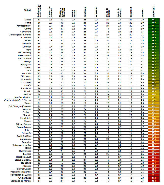
Mexican market research firm Gabinete de Comunicación Estratégica polled 30,400 people across the country to compile its 10th annual survey of the most livable cities in Mexico. The survey was carried out by telephone between 30 June and 19 July this year. Respondents in Mexico’s 60 most populous municipalities and Mexico City’s 16 delegaciones were asked a series of questions related to quality of life and level of services provided in each city. [Given the sample size, at a confidence level of 95% the maximum expected error for each municipality was ±4.9%]
The survey looked at numerous variables to quantify “quality of life”, including housing, schools, mobility, air pollution and employment. The survey also considered satisfaction with services, and satisfaction with the performance of the city’s mayor.
For quality of life, the top ranking city overall, for the second year running, was Mérida (Yucatán), which scored 77.6 points out of 100, followed by Saltillo (77), Aguascalientes (71.6), Colima (70.9) and Campeche (69.8). Monterrey came in 12th in the survey rankings (see table), while Guadalajara placed in the middle.
The four least livable cities in the study were Villahermosa (52.9), Naucalpan (51.3), Chilpancingo (49.8) and Ecatepec (48.8).
Full report: Ciudades más habitables de México 2016 (pdf)
OtherComments Off on The deepest water-filled sinkhole in the world is in Tamaulipas, Mexico
Oct122016
As vertical shafts go, this is a seriously deep one! Long considered to be “bottomless” (because no-one had ever managed to find the floor), we now know it is precisely 335 meters (1099 feet) deep, making it the deepest water-filled sinkhole anywhere on the planet.
The El Zacatón sinkhole is on El Rancho Azufrosa, near the town of Aldama in Tamaulipas in northeast Mexico. The sinkhole or cenote is one of several located in the same area, though recent studies have failed to demonstrate any obvious underground connections between them. The term cenote is a Spanish rendering of the Mayan word d’zonot, “a hole in the ground”. The El Zacatón pit, which is about 110 meters (360 feet) across and roughly circular, contains a deep lake. The water is warm (averaging about 30 degrees C), highly mineralized and has a sulfurous odor. The name El Zacatón comes from the floating islands of grass (zacate) which blow across this lake from one side to the other with the wind.
The pit’s depth has attracted serious divers for many years. In 1993, Dr. Ann Kristovich dove to a new women’s world record depth of 169 meters (554 feet). The following year, two American explorers tried to reach the bottom of the sinkhole. Jim Bowden successfully reached a men’s world record depth of 282 meters (925 feet) but still did not touch the bottom. Tragically, his diving partner Sheck Exley died during the attempt.
The mystery of the sinkhole’s depth was finally solved in 2007. A multi-million dollar exploration, mainly funded by NASA, trialled the Deep Phreatic Thermal Explorer (DEPTHX) robot, designed to explore ice-covered Europa, Jupiter’s smallest moon. Partners on the DEPTHX project include Carnegie Mellon University, Southwest Research Institute, Colorado School of Mines, The University of Arizona, and the University of Texas at Austin’s Jackson School of Geosciences. In the words of a NASA press release, The Deep Phreatic Thermal Explorer (DEPTHX) is a 3,300-pound, computerized, underwater vehicle that makes its own decisions. With more than 100 sensors, 36 onboard computers, and 16 thrusters and actuators, it decides where to swim, which samples to collect, and how to get home.
Exploring El Zacatón pit was considered to be an ideal preliminary test of the DEPTHX autonomous robot, which is about the size of a go-kart. The robotic vehicle successfully generated a highly detailed sonar map of the sinkhole, and obtained samples of water and biotic material from the walls, discovering several new phyla of bacteria in the process. Its next challenge is to explore beneath the ice of West Lake Bonney in Antarctica.
At El Zacatón, the sonar study showed that the sinkhole has a total depth of 335 meters: the lake is 319 meters deep at its deepest point, and its surface is 16 meters below the height of the sinkhole’s rim.
El Pico de Orizaba, or Citlaltépetl (= “star”), is Mexico’s highest peak, rising to a summit 5,610 meters (18,406 feet) above sea level. The third highest peak in North America, it is also that region’s highest volcano, responsible for major eruptions in 1569, 1613 and 1687. The mountain was first explored by scientists as long ago as 1838.
Located east of Mexico City, some 30 kilometers (20 miles) northwest of the city of Orizaba, it is regularly climbed today by well-equipped groups, especially during the dry season, from December to April. Its classical cone shape masks an impressively large crater, which is more than 300 meters (1,000 feet) deep. The volcano and surrounding area were declared a national park by President Lázaro Cárdenas in 1936; the decree took effect the following January.
Among the first recorded ascents is that in August 1838 by a group of several European botanists: Henri Galeotti, Nicolas Funck, Auguste Ghiesbreght and Jean-Jules Linden. The group spent eleven days on the volcano and their subsequent accounts of the expedition show that they definitely reached the summit. Afterwards, they went on to have distinguished careers in their specialist fields.
By the time of the climb, Henri Guillaume Galeotti (1814-1858) had already written a landmark article about Lake Chapala, and made numerous botanical discoveries in Mexico. He went on to become Director of the Royal Botanical Gardens in Brussels, Belgium.
Less is known about the achievements of Nicolas Funck (1816-1896), who continued traveling in Mexico until 1842. He subsequently became director of Brussels Zoo (1861) and then Cologne Zoo.
After the climb, Auguste Ghiesbreght (1810-1893) set up his own business in Mexico, making a living by supplying plants and natural history specimens to European collectors and his botanist business partners. Who knows? Perhaps the plans for a cacti-exporting business (Galeotti) and large-scale orchid cultivation (Linden) were hatched while the group of young friends were battling their way towards the peak of Orizaba.
Jean Jules Linden (1817-1898), born in Luxembourg, collected for the Belgian government in Brazil, Mexico and Guatemala, before becoming one of the world’s most celebrated importers of plants. He set up nurseries for exotic plants in Brussels and Ghent in Belgium, as well as on the French Mediterranean coast. He also directed Brussels Zoo. He is credited with introducing and popularizing numerous plants, including begonias, palm trees and orchids. His superb publications on orchids and his marketing skills won him world-wide respect.
The nineteenth century craze for orchids in Belgium had numerous parallels with the craze three hundred years earlier for tulips in the Netherlands. The nouveau-riche industrialists satisfied their passion for expensive and unusual orchids by buying them from Linden who was propagating and growing them in massive, industrial-scale glasshouses. Even the Russian czar bought orchids from Linden!
El Pico de Orizaba (from Oswald’s Summerland Sketches, 1880)
The explorations of Galeotti and his friends resulted in the volcano becoming much better known. A decade later, Carl Sartorius, an artist of German extraction who collected plants for the Berlin Botanical Gardens, and who owned the El Mirador hacienda close to the volcano, organized an expedition to reach the summit. When they reached the top, they found a simple plaque there already, left by two US soldiers, F. Maynard and G. Reynolds, who had served as troopers in Winfield Scott’s army during the 1846-1848 Mexican-American war.
Not surprisingly, the upper reaches of El Pico de Orizaba (above about 4,000 meters) are snow-capped all year. Though someone had probably skied down the mountain previously, the first recorded descent on skis was made by W. Furlinger in 1974. Schemes to open a skiing resort on its slopes have been suggested several times. Before any budding entrepreneurs get carried away with the possibilities, it should be pointed out that setting up permanent ski runs on the slopes of El Citlaltépetl may not be too smart an idea, given the likely impact of global warming.
This is an edited and updated version of an article originally published on MexConnect.
Acknowledgment
My thanks to Dr. Winston Crausaz. the author of Pico de Orizaba or Citlaltepetl (Geopress International, 1993), whose valuable comment on the original post (see below) has now been incorporated into the updated version above.
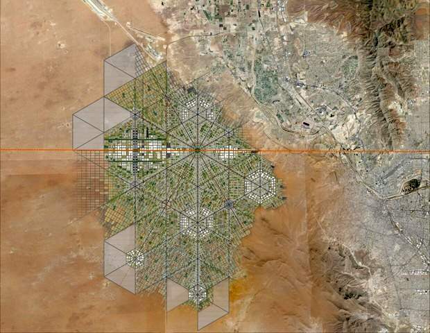
This proposal sounds a lot more 21st century than Trump’s plan for a wall along the Mexico-U.S. border. Will either proposal ever actually happen? Most likely not. But that does not prevent us from considering the former project one more than worthy of mention here.
Young Mexican architect Fernando Romero has long believed that “building bridges” is preferable to creating obstacles and that conventional boundaries “are just becoming symbolic limits.”Romero was named a “Global Leader of Tomorrow” at the World Economic Forum in 2002.
Masterplan for trans-border city. (Fernando Romero Enterprise)
To illustrate his viewpoint, Romero recently released a master plan for a walkable, super-connected metropolis straddling the U.S.-Mexico border. More than a decade ago, Romero’s architecture firm proposed a tunnel-like “Bridging Museum” crossing the Mexico-U.S. border in the Rio Grande Valley. His more recent suggestion of a utopian border city, presented at the London Design Biennale, is far more ambitious and would take advantage of the concept of special economic zones (employed earlier this year by Mexico’s federal government to stimulate development in several southern states).