Mexican architect proposes city straddling Mexico-U.S. border

 Mexico's geography in the Press  Comments Off on Mexican architect proposes city straddling Mexico-U.S. border
Oct 032016
 

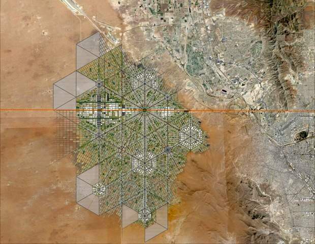
This proposal sounds a lot more 21st century than Trump’s plan for a wall along the Mexico-U.S. border. Will either proposal ever actually happen? Most likely not. But that does not prevent us from considering the former project one more than worthy of mention here.

Young Mexican architect Fernando Romero has long believed that “building bridges” is preferable to creating obstacles and that conventional boundaries “are just becoming symbolic limits.”Romero was named a “Global Leader of Tomorrow” at the World Economic Forum in 2002.

Masterplan for trans-border city. (Fernando Romero Enterprise)

Masterplan for trans-border city. (Fernando Romero Enterprise)

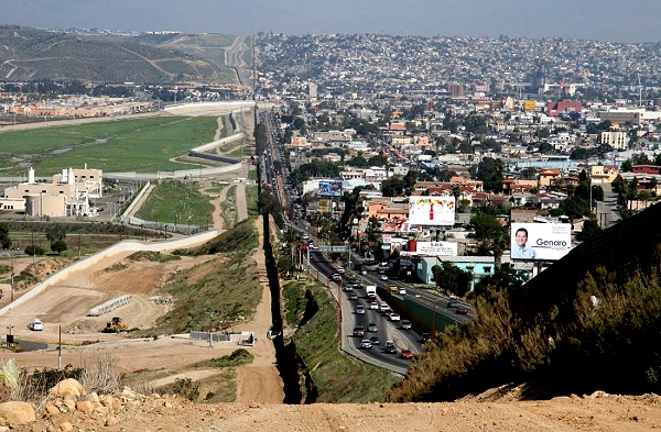
To illustrate his viewpoint, Romero recently released a master plan for a walkable, super-connected metropolis straddling the U.S.-Mexico border. More than a decade ago, Romero’s architecture firm proposed a tunnel-like “Bridging Museum” crossing the Mexico-U.S. border in the Rio Grande Valley. His more recent suggestion of a utopian border city, presented at the London Design Biennale, is far more ambitious and would take advantage of the concept of special economic zones (employed earlier this year by Mexico’s federal government to stimulate development in several southern states).

To read more about this exciting proposal, with numerous stunning images of what it might look like, see “Instead of Trump’s Wall, Why Not a Binational Border City?

For more about the U.S.-Mexico border zone, see these related Geo-Mexico posts:

Aug 112014
 

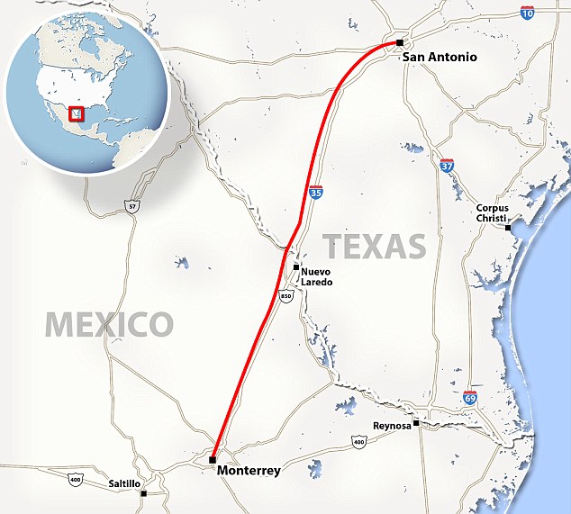
Earlier this year, a slew of press reports discussed the possibility of a Mexico-USA high speed rail link from the industrial powerhouse of Monterrey in Nuevo León state to San Antonio in Texas. (For one example, see Fast train to Monterrey on the horizon).

The reports say that Mexican transport officials and their U.S. counterparts believe that this international high speed rail link could be in operation within a decade. The new line would move passengers between the two cities in about two hours, saving almost three hours compared to highway travel.

Route of proposed high speed train from Monterrey to San Antonio. Credit: Daily Mail.

Route of proposed high speed train from Monterrey to San Antonio. Credit: Daily Mail.

A key part of the plan would be a system to pre-clear U.S. Customs which sometimes delays northbound motorists at border crossings for several hours. (Such a pre-clearance system would be analogous to that already operating in several Canadian airports, where U.S.-bound passengers clear U.S. immigration and customs prior to boarding their flights).

Mexican officials have already secured the rights of way for the rail line from Monterrey to the U.S. border and say that this section of the line, likely to cost around 1.5 billion dollars, could be up and running as early as 2018. The U.S. section, from the border northwards, is unlikely to be completed before 2022 at the earliest, though a $5.6 million study of potential high-speed rail lines stretching from Laredo to Oklahoma City is already underway.

The first high speed rail links in North America are likely to be in Mexico, where planning is well advanced and the first construction contracts are being awarded for building high speed links from Mexico City to Toluca and Querétaro. Plans for a high speed train in the Yucatán Peninsula have also been announced.

For more details of the Mexico City-Toluca high speed rail project, see Plans to improve the Mexico City-Toluca transport corridor.

Want to read more?

Mexicali receives more deportees than any other Mexican border city

 Mexico's geography in the Press  Comments Off on Mexicali receives more deportees than any other Mexican border city
Jan 182014
 

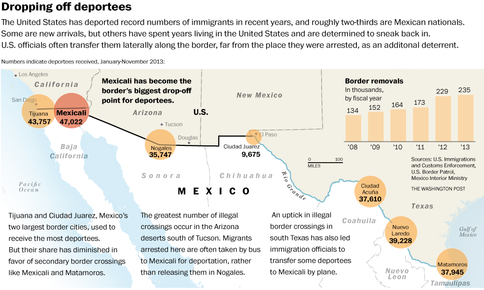
A recent Washington Post article – Mexicali has become Mexico’s city of the deported as U.S. dumps more people there – highlights the fact that Mexicali now has the dubious distinction of receiving more deportees from the USA than any other Mexican border city.

As the article points out, “Once, border cities like Mexicali (population 700,000) were flooded with newcomers trying to go north. Today, they are filling with obstinate deportees, cut off from U.S.-born children, jobs and car payments, adrift in a kind of stateless purgatory that is beyond the United States but not really in Mexico either. They face a U.S. border that is tougher and more expensive to cross than ever.”

The U.S. Immigration and Customs Enforcement (ICE) agency deported more than 400,000 migrants in the 2012 fiscal year, and close to 370,000 in 2013, about two-thirds of them to Mexico. Mexican government statistics for that time frame show that more than 110,000 were “repatriated” to Mexicali, even though it was not their point of origin, or even the closest Mexican border city to where they were detained.

According to the Mexican Ministry of Foreign Affairs (SRE) the deportees from the USA in 2012 included 13,454 unaccompanied Mexican minors under the age of 18.

This Washington Post graphic (click image to enlarge) neatly summarizes the situation.

Number of people deported to Mexico's border cities

Number of people deported to Mexico’s border cities. Click to enlarge. Credit: Washington Post.

The Washington Post article makes for some sober reflections on the plight of many of those deported from the USA, especially those individuals who have very strong family ties to that country.

The longer term social effects of such deportations are the focus of this article by Joanna Dreby, assistant professor of sociology at the University of Albany, State University of New York.

Related posts:

Nov 162013
 

In an alliance with the Sonoran Institute, the National Geographic Center for Sustainable Destinations helped the region’s communities create the first transborder Geotourism MapGuide, covering northern Sonora and southern Arizona. The mapguide was published in 2007:

The maps  have vignettes of information about history, culture, geology and many other aspects of the region, making it a useful guide for geo-tourists. While some might argue about the choice of locations and attractions described on the maps, this is a useful addition to the background reading for anyone thinking of traveling to this region with some time on their hands to explore.

Surprisingly, the map has only a very brief and somewhat dismissive mention of the El Pinacate and Gran Desierto de  Altar Biosphere Reserve:

“Stand at the rim of this mile-wide volcanic crater and you may feel as if you’re on the moon. This land of ancient lava, sand, and cinder cones is sacred to the O’Odham people. Today, those on the Sonora side of the border call themselves “Pápago.”

Related posts:

Cross-border tribe faces a tough future

 Other  Comments Off on Cross-border tribe faces a tough future
Sep 162013
 

In this post, we consider the unfortunate plight of the Tohono O’odham people, whose ancestral lands now lie on either side of the Mexico-USA border.

How did this happen?

Following Mexico’s War of Independence (1810-1821), the rush was on to draw an accurate map of all of Mexico’s territory. Mexico’s boundaries following independence were very different to today. At that time, the major flows of migrants linking the USA to Mexico were from the USA to Mexico, the reverse of the direction of more recent flows, where millions of Mexicans have migrated north.

As this map of Mexico in 1824 shows, Mexico’s territory extended well to the north of its present-day limits.
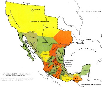
Map of Mexico, 1824

Map of Mexico, 1824

At the end of the Mexican-American War (1846-1848) the 1848 Treaty of Guadalupe Hidalgo ceded over half of Mexico’s territory to the USA. A few years later, under the 1853 Gadsden Purchase (Treaty of La Mesilla), northern portions of Sonora and Chihuahua (shaded brown on the map below) were transferred to the USA.
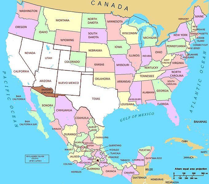
Mexico 1853

Source: National Atlas of the United States (public domain)

With minor exceptions since, to take account of changes in the meanders of the Río Bravo (Grande), this established the current border between the two countries.

Impacts on the Tohono O’odham people

One of the immediate impacts of the Gadsden purchase was to split the lands of the Tohono O’odham people into two parts: one in present-day Arizona and the other in the Mexican state of Sonora, divided by the international border. The O’odham who reside in Mexico are often known as Sonoran O’odham.

There are an estimated 25,000 Tohono O’odham living today. Most are in Arizona, but about 1500 live in northern Sonora. In contrast to First Nations (aboriginal) groups living on the USA-Canada border who were allowed dual citizenship, the Tohono O’odham were not granted this right. For decades, this did not really matter, since the two groups of Tohono O’odham kept in regular contact for work, religious ceremonies and festivals, crossing the border when needed without any problem. Stricter border controls introduced in the 1980s, and much tightened since, have greatly reduced the number of Tohono O’odham able to travel freely. This is a particular problem for the Tohono O’odham in Sonora, most of whom were born in Mexico but lack sufficient documentation to acquire a passport.

Tohono o'odhum border protest

Tohono O’odham border protest

Since 2001, several attempts have been made in the USA to solve the “one people-two country” problem by granting U.S. citizenship to all registered members of the Tohono O’odham, regardless of their residence. So far, none has succeeded.

The largest community in the Tohono O’odham Nation (the Arizona section of Tohono O’odham lands) is Sells, which functions as the Nation’s capital. The Sonoran O’odham live in nine villages in Mexico, only five of which are offically recognized as O’odham by the Mexican government.

The border between the two areas is relatively unprotected compared to most other parts of the Mexico-USA border.

The Tohono O’odham Nation is often called upon to provide emergency assistance to undocumented workers (and drug traffickers) from south of the border who have underestimated the severe challenges of crossing this section of the harsh Sonora desert. Tribal officials regularly complain about the failure of the U.S. federal government to reimburse their expenses.

ABC News reports (Tohono O’odham Nation’s Harrowing Mexican-Border War) that the border “has made life a daily hell for a tribe of Native Americans” and that drug seizures on the Tohono O’odham Nation’s lands have increased sharply.

Want to read more?

  • The Sonoran O’odham lieutenant governor continues to help after 16 years
  • A story passed down from generation to generation  (Lisa Palacios, a Tohono O’odham anthropology student at the University of Arizona with relatives on both sides of the border shares her grandparents’ story)
Jun 082013
 

This 30 minute video (narrated in Spanish with English subtitles) looks at the vexed situation of Mexican workers that have been deported from the USA back into Mexico. About 200 migrants are deported daily. Almost all are male,. Many of them have lived for several years in the USA prior to deportation, and some have wives and families still living north of the border.

About 45% of all migrants from Mexico to the USA crossed the border between Tijuana and California. Since 1994 (Operation Gatekeeper) crossing the border has been made progressively more difficult. The border is now heavily protected with border guards given access to technology such as night-vision telescopes and a network of seismic monitors (to detect the minor ground movements that signal people walking or running through the desert). As the US economy ran into problems a few years ago, the flow of migrants north slowed down, even as authorities in the US launched more raids against undocumented workers, leading to an increase in the number of workers deported.

In the video, a range of stakeholders are given the chance to explain how they see the problems faced by deportees. A social anthropologist provides some background and academic insights; activists explain their position and how they seek to help deportees; several individual deportees share their experiences and invite us into their “homes”, precarious one-room shacks, some built partially underground, hobbit-like, in “El Bordo”, a section of the canalized channel of the Tijuana River that runs alongside the international border.

The garbage-strewn El Bordo has sometimes housed as many as 4,000 deportees. Mexican authorities are anxious to clean the area up and periodically bulldoze any shacks they find.

These personal stories of workers from interior states such as Puebla are harrowing. Many still seek “the dream” and openly admit they do not want to return to their families as a “defeated person”.

While parts of this video might have benefited from tighter editing, the accounts are thought-provoking and the video is an outstanding resource to use with classes considering the longer-term impacts of international migration.

There seems little doubt that a majority of the “residents” of El Bordo has a serious drug problem, and the video includes interviews about this issue with municipal police, deportees and aid workers, who discuss the problems and suggest some possible solutions, but ultimately, the city and state authorities have some tough decisions to make if they are to resolve this serious, and growing, humanitarian problem.

Related posts:

Two examples of Mexico-USA trans-border water pollution

 Mexico's geography in the Press  Comments Off on Two examples of Mexico-USA trans-border water pollution
Aug 092012
 

In a previous post – Update on the severe drought in northern Mexico – we mentioned two cases where water was being transferred across the Mexico-USA border and where it was proving impossible to meet the terms of existing water treaties in the face of the severe drought in northern Mexico and the southern USA.

In this post, we look at two examples where the major trans-border concern is about water quality not quantity.

Case 1: The New River, California

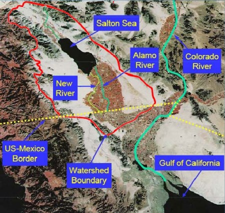
The New River begins in Mexico as the Río Nuevo and receives agricultural runoff and industrial and domestic wastewater from the 1,000,000 or so residents of the metropolitan area of Mexicali, where a water treatment plant now operates. The New River then crosses the border northwards into California (west of the Colorado River) and flows into that state’s largest lake, the Salton Sea. The New River is about 130 kilometers long, with only the first 25 kilometers in Mexico.

The trans-border drainage basin of the New River

The trans-border drainage basin of the New River. Credit: IBWC.

The New River has a long history of high pollution levels, well documented in this Wikipedia entry: New River (Mexico – United States) and is possibly the most polluted river of its size anywhere in the USA. It is also one of the routes used by undocumented migrants entering the USA, as pointed out in this 2-minute video:

The California-Mexico Border Relations Council’s technical advisory committee recently announced a strategic plan to start cleaning up the polluted waters of the New River. In the Californian border city of Calexico, the plan calls for the installation of a 90-million-dollar water disinfection system and trash screens. Downstream, it also includes the creation of water-filtering wetlands in parts of the Imperial Valley, one of the USA’s most important agricultural areas. The strategic plan will also develop an integrated water quality monitoring and reporting program, so that changes in water quality can be quickly traced to source and any necessary cleanup measures can be implemented. The condition of the New River has been improving in the past decade, but much work remains to be done.

Case 2: Wastewater in Nogales, Arizona.

Further east along the border, Arizona state officials are suing the International Boundary and Water Commission (IBWC) for violations to the United States Clean Water Act, alleging that untreated Mexican industrial wastewater, mixed with domestic sewage, continues to cross the USA-Mexico border into the city of Nogales, Arizona. The suit claims that the wastewater has levels of cadmium, cyanide and ammoniacal nitrogen well above legal limits. The Arizona Department of Environmental Quality is demanding that the IBWC install an industrial waste treatment system at the Nogales International Wastewater Treatment Plant.

Related posts:

The maquiladora export landscape

 Books and resources, Teaching ideas  Comments Off on The maquiladora export landscape
Oct 102011
 

InfraNet Lab is “a research collective probing the spatial byproducts of contemporary resource logistics.” Given its emphasis on spatial aspects, it includes many topics of interest to geographers.

InfraNet Lab was included on Planetizen’s 2009 list of the 10 best planning, design, and development websites. Planetizen describes InfraNet Lab as:

“An intense and directed blog focusing on the physical manifestations of controlling resources. It’s a fresh look at the impacts of modern world’s infrastructural needs and the intertwined networks between urbanism, architecture and landscape that result. With archives dating back to April 2008, InfraNet Lab offers a crash course in innovative ideas that reframe the infrastructure conversation around the impacts of human resource dependence and, ultimately, methods for making improvements. An insightful and inciting read for anyone feeling underwhelmed by the status quo of modern-day infrastructure.”

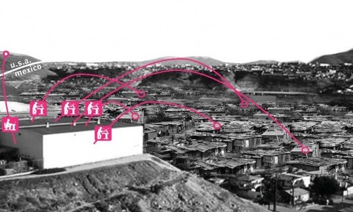
One post on InfraNet Lab of particular interest to us is the guest post by Juan Robles, following an InfraNet Lab seminar at Daniels Faculty of Architecture, Landscape, and Design at the University of Toronto. Robles writes about the landscapes resulting from the growth of maquiladoras in Mexico. He looks at how the necessary infrastructures and networks for maquiladoras to succeed have developed, and how they have transformed the Mexico-US border area. The changes have certainly been profound:

“The ongoing processes of trade and communication that now integrate the 21st century regional economies have created numerous territories of abundance. Among these spaces the maquiladora landscape, in the northern border of Mexico, has seen the greatest change in the last 50 years.”

This is a well illustrated account of the spatial changes associated with maquiladoras, and includes a variety of useful maps and graphics.

Shanty towns support maquiladoras

Shanty towns support maquiladoras. Credit: Juan Robles/InfraNet Lab.

InfraNet Lab is a valuable resource for AP, A-level and IB. In InfraNet Lab’s words:

The globe’s networked ecologies of food, water, energy, and waste have established new infrastructures and forms of urbanism linking dispersed entities. These agglomerations evolve and shift as resources are uncovered or depleted. While these ecologies exist at the service of our contemporary lifestyles, they have typically remained hidden from view and from the public conscience. Yet as resources of food, fuel and water begin to run scarce, new resources are mined and new networks develop.

InfraNet Lab takes the view that “Long accepted patterns of globalization are being called into question as transportation costs soar and resources run scare, transforming mobility and trading patterns. New local, regional and international networks of goods, movement and trade are beginning to emerge.”

This means that InfraNet Lab offers some very valuable resources for courses such as the IB Geography’s Paper 3 for Higher Level students which looks at the impacts of all kinds of international interactions.

The reasons why Mexico is fast becoming a key player in aerospace manufacturing

 Updates to Geo-Mexico  Comments Off on The reasons why Mexico is fast becoming a key player in aerospace manufacturing
Sep 172011
 

In a previous post, we looked at why  Querétaro has become a hub of aerospace manufacturing, home to major manufacturing or research plants for such firms as Bombardier and GE.

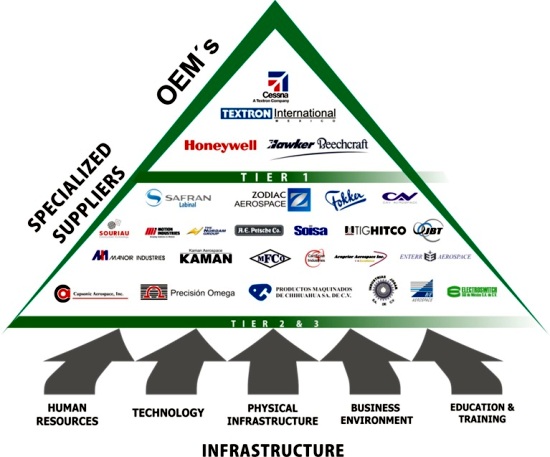
In this post we take a further look at the aerospace industry in Mexico, which, according to ProMexico,  the Mexican federal agency that promotes trade and investment, has expanded at 17% a year since 2005. Mexico’s aerospace manufacturing, which began as a relatively simple assembly industry, has evolved today into sophisticated aero-parts and fuselage manufacturing, well supported by specialist education and training programs. In the next phase, Mexico is expected to acquire full service airplane assembly meeting all relevant international design and innovation requirements.

Aerospace parts

The shift in aerospace from simple assembly to complex design, manufacturing and research, echoes what has already happened in some other sectors, such as vehicle manufacture.

Today, the aerospace industry employs 32,000 people in 16 Mexican states. the four most important states for the aerospace industry in Mexico are Baja California, Querétaro, Nuevo León and Chihuahua.

Approximately half the jobs in the sector are located in Baja California, mainly in either Tijuana or Mexicali. The first two aerospace companies to locate in Baja California (in the mid 1960s) were Rockwell Collins and Switch Luz. Today, aerospace firms in Baja California make electronic components, air conditioning systems, cable harnesses, hoses and seals, rustless steel bolts, turbine connector assemblies and blankets for commercial and military aircraft. Honeywell International has been influential in developing aerospace in Baja California since 2007, when it opened a testing facility in Mexicali.

How important is the aerospace sector in Mexico?

  • The number of aerospace manufacturing companies in Mexico is expected to grow from 232 in 2010 to more than 350 in 2015.
  • The aerospace sector is expected to provide 37,000 direct jobs in 2015, 28% more than in 2010
  • Exports of aerospace parts were worth $3.1 billion in 2010, a figure expected to jump to $5.7 billion by 2015.

Aerospace firms

The major factors that have helped Mexico set up and develop aerospace manufacturing are:

  • Mexico has the second largest fleet of private aircraft in the world after the USA,
  • Since 2009, it has become one of the world’s largest recipients of aerospace foreign direct investment
  • Mexican firms meet technical requirements and delivery schedules
  • Mexico offers easy access to raw materials for all phases of production
  • The Mexican market is economically, socially and politically stable
  • The government has offered strong support for the aerospace industry in Mexico. Import duties on aeronautics components were abolished in Mexico in 2007, the same year that Mexico and the USA signed a Bilateral Aviation Safety Agreement to facilitate cross-border aviation-related trade and services
  • Several Mexican states, especially those along the northern border have a well-established industrial infrastructure
  • The proximity of Baja California to the established aerospace industry and important aerospace markets in California, has been an important stimulus to aerospace firms in that state
  • Overall, Mexico offers lower production costs
  • Labor costs are not as cheap as India and China, but that is more than compensated by reduced transport costs. Aerospace parts made in Mexico can reach an assembly plant in the USA in 16 hours by road, compared to about 21 days from China by sea.
  • There is a large pool in Mexico of skilled labor, trained for electronics and auto-parts manufacturing.
  • Mexico’s workers are well educated, with sound engineering and technical skills

The available evidence suggests that there are now more engineering courses and graduates in Mexico each year than in the USA. The number of engineering graduates in the USA has not risen in recent years, and the number of engineering courses has actually declined. In Mexico, the numbers of engineering courses and graduates have both continued to grow at a very rapid rate. Specialist courses are already training students for the aerospace industry. For example the private university CETYS,  with campuses in Tijuana and Mexicali, has added aerospace to its graduate and undergraduate curricula and also offers a Master’s in Aerospace Engineering. Undergraduate programs in aerospace have been introduced at two public universities: the Autonomous University of Baja California and the Tijuana Technological Institute. The Tijuana Technological University has started to train technicians in assembling harnesses for the aerospace industry, modeled on a curriculum developed for a technical school in Toulouse, France (the home of Airbus).

Upcoming trade event:

Mexico is hosting an Aerospace Summit in the city of Chihuahua, October 18-20, 2011, in the Chihuahua Convention Center. (Graphics used above come from the trade event site.)

Sources include:

Could Southern California’s water woes be eased by a desalination plant in Mexico?

 Mexico's geography in the Press  Comments Off on Could Southern California’s water woes be eased by a desalination plant in Mexico?
Aug 042011
 

Southern California water officials are reportedly considering helping to finance a desalination plant in Mexico as a partial solution to their on-going water issues.

A desalination plant proposed by San Diego County Water Authority and Metropolitan Water District of Southern California, and planned for north of the border in Carlsbad (San Diego County) has been tied up in lawsuits and permitting problems for over a decade. As a result, three states—California, Arizona and Nevada—originally approached Mexico about sharing a desalination plant.

Now, however, the San Diego County Water Authority and Metropolitan Water District of Southern California have proposed a new plant located in Rosarito, Baja California, across the border from San Diego. The plant would have a capacity of 284,000 cubic meters (75 million gallons) of water a day to serve communities on both sides of the border. Construction could begin as early as 2013, at an estimated total cost of $1 billion (one-third of which would be contributed by Mexico).

The proposal has been roundly condemned by several environmental groups, who claim it is an attempt to legitimize the unsustainable usage of water in southern California, while simultaneously destroying marine life off the coast of Baja California.

Related post:

Mexico’s water resources and water-related issues are the subject of chapters 6 and 7 of Geo-Mexico: the geography and dynamics of modern Mexico. Ask your library to buy a copy of this handy reference guide to all aspects of Mexico’s geography today! Better yet, order your own copy…