Aug 282018
 

For anyone who continues to doubt the potentially disastrous impacts of building a wall along the U.S.-Mexico border on wildlife (let alone people), then perhaps these two articles will help you decide which side of the fence you want to be on:

See also:

No wall necessary: the USA-Mexico border at Nogales in 1915

 Other  Comments Off on No wall necessary: the USA-Mexico border at Nogales in 1915
Feb 232017
 

There are almost fifty places where people can legally cross the Mexico–United States border, but only one where the cities on either side of the border have the same name: Nogales.

transnational-metropolitan-areas

The fascinating history of the two Nogales (Ambos Nogales), twin cities on either side of the border, is related in this detailed 2010 blog post by Robert Lucas: Ambos Nogales Face Across the Border.

The geographic curiosities of the border between Nogales (Sonora) and Nogales (Arizona) included, historically, a street that ran east-west along the border, with one half of the street in Mexico and the other half in the USA:

Postcard of Ambos Nogales, ca 1915

Postcard of Ambos Nogales, ca 1915

This postcard from about one hundred years ago shows International Avenue, Nogales. The boundary line on the postcard was added by the publisher to indicate that the border ran down the middle of the street. Even in the absence of any boundary fence, residents were apparently still required to cross at one of two entry points: either the Morley Avenue crossing (shown in the postcard) or the Grand Avenue crossing further to the west.

Prior to the building of the International Avenue, which created a clear separation between Mexico and the USA, there had been some interesting consequences of having a bi-national city straddling the international border. For example, after Arizona introduced prohibition, outlawing the production and sale of alcohol in that state, some publicans took advantage of the unusual geography of Nogales to build saloons that straddled the border. Patrons tired of sipping their tea who wanted to enjoy duty-free mescal could simply move to the south end of the bar…

In 1897, the U.S. Congress ordered that a 60-foot strip along the border in downtown Nogales be cleared of all structures as a measure to suppress customs fraud. Mexico soon followed suit, creating the International Avenue. The International Avenue did not look like the view in the postcard for for very long. By 1916, a temporary fence had been erected down the middle.

Two years later, on 27 August 1918, this area was the scene of the Battle of Ambos Nogales (La batalla del 27 de agosto), which led to a permanent fence being built, forever separating Ambos Nogales into two distinct cities.

Related posts:

Mexican architect proposes city straddling Mexico-U.S. border

 Mexico's geography in the Press  Comments Off on Mexican architect proposes city straddling Mexico-U.S. border
Oct 032016
 

This proposal sounds a lot more 21st century than Trump’s plan for a wall along the Mexico-U.S. border. Will either proposal ever actually happen? Most likely not. But that does not prevent us from considering the former project one more than worthy of mention here.

Young Mexican architect Fernando Romero has long believed that “building bridges” is preferable to creating obstacles and that conventional boundaries “are just becoming symbolic limits.”Romero was named a “Global Leader of Tomorrow” at the World Economic Forum in 2002.

Masterplan for trans-border city. (Fernando Romero Enterprise)

Masterplan for trans-border city. (Fernando Romero Enterprise)

To illustrate his viewpoint, Romero recently released a master plan for a walkable, super-connected metropolis straddling the U.S.-Mexico border. More than a decade ago, Romero’s architecture firm proposed a tunnel-like “Bridging Museum” crossing the Mexico-U.S. border in the Rio Grande Valley. His more recent suggestion of a utopian border city, presented at the London Design Biennale, is far more ambitious and would take advantage of the concept of special economic zones (employed earlier this year by Mexico’s federal government to stimulate development in several southern states).

To read more about this exciting proposal, with numerous stunning images of what it might look like, see “Instead of Trump’s Wall, Why Not a Binational Border City?

For more about the U.S.-Mexico border zone, see these related Geo-Mexico posts:

Mexican business association tries to counter rhetoric of U.S. political campaigns

 Mexico's geography in the Press  Comments Off on Mexican business association tries to counter rhetoric of U.S. political campaigns
Jul 142016
 

Mexico’s Business Coordination Council (Consejo Coordinador Empresarial, CCE) has launched a publicity drive to counter the disinformation and anti-Mexican rhetoric emerging in U.S. political campaigns. The details of the publicity drive remain unclear.

Juan Pablo Castañón, CCE’s president, says the aim is to emphasize the true strength and importance of good Mexico-U.S. relations. In particular, the NAFTA trade zone accounts for 15% of global trade, 28% of global GDP and 14% of FDI flows. Trade between the three partners has quadrupled since 1993 and exceeded a trillion dollars in 2015, half of which is attributable to U.S.-Mexico trade.

Mexico is the second most important destination for U.S. exports and the main market for exports from California, Arizona, New Mexico and Texas. Goods worth 500 million dollars cross the border daily.

According to Castañón, if U.S. politics puts a brake on this trade, more than six million U.S. workers could lose their jobs. Proposed tariffs on imports of flat screens and vehicles would raise prices significantly in the USA. In addition, 80% of avocados and 50% of tomatoes sold in the USA come from Mexico.

Related posts

May 192016
 

An unclassified DEA Intelligence Report from a year ago has just resurfaced on my desk. Entitled United States: Areas of Influence of Major Mexican Transnational Criminal Organizations, it includes two particularly interesting maps.

The report states that “Mexican transnational criminal organizations (TCOs) pose the greatest criminal drug threat to the United States; no other group is currently positioned to challenge them. These Mexican poly-drug organizations traffic heroin, methamphetamine, cocaine, and marijuana throughout the United States, using established transportation routes and distribution networks. They control drug trafficking across the Southwest Border and are moving to expand their share, particularly in the heroin and methamphetamine markets.”

As of May 2015, the DEA identified the following cartels that operate cells within the USA: the Sinaloa Cartel, Gulf Cartel, Juarez Cartel, Knights Templar (Los Caballeros Templarios or LCT), Beltran-Leyva Organization (BLO), Jalisco New Generation Cartel (Cartel Jalisco Nueva Generacion or CJNG), Los Zetas, and Las Moicas.

The maps reflect “data from the Organized Crime Drug Enforcement Task Force (OCDETF) Consolidated Priority Organization Target (CPOT) program to depict the areas of influence in the United States for major Mexican cartels.”

DEA-Mexican cartel influence in USA

DEA-Mexican cartel influence in USA

Figure 1 (click map to enlarge) shows the distribution of DEA Field Offices. The pie chart for each office shows “the percentage of cases attributed to specific Mexican cartels in an individual DEA office area of responsibility”.

“Since 2014, the Arellano-Felix Organization, LCT, and the Michoacán Family (La Familia Michoacán LFM) cartels have been severely disrupted, which subsequently led to the development of splinter groups, such as, “La Empresa Nueva” (New Business) and “Cartel Independiente de Michoacan” (Independent Cartel of Michoacan) representing the remnants of these organizations.”

Figure 2 (below) shows the dominant transnational criminal organization (TCO) in each domestic DEA Field Division, relative to other active TCOs in the same geographic territory. The map includes population density shading which “is intended to depict potential high density drug markets that TCOs will look to exploit through the street-level drug distribution activities of urban organized crime groups/street gangs.”

DEA-Mexican cartel influence in USA

DEA-Mexican cartel influence in USA

“The Sinaloa Cartel maintains the most significant presence in the United States. They are the dominant TCO along the West Coast, through the Midwest, and into the Northeast. While CJNG’s presence appears limited to the West Coast, it is a cartel of significant concern, as it is quickly becoming one of the most powerful organizations in Mexico, and DEA projects its presence to grow in the United States over the next year. In contrast, Mexican cartels such as the Gulf, Juarez, and Los Zetas hold more significant influence closer to the Southwest Border, but as shown on the map, their operational capacity decreases with distance from the border.”

Other, smaller, “splinter groups from the disrupted LCT organization continue to traffic drugs from the Michoacán, Mexico area into the United States. The BLO, former transportation experts for the Sinaloa Cartel, is most active along the East Coast and is also responsible for the majority of heroin in the DEA Denver area of responsibility. Las Moicas is a Michoacán-based organization with former LFM links, but remains a regional supplier in California and operate on a smaller scale relative to other major Mexican TCOs.”

Related posts:


Trump’s U.S.-Mexico Border Wall is already almost complete

 Books and resources  Comments Off on Trump’s U.S.-Mexico Border Wall is already almost complete
Mar 242016
 

A recent National Geographic piece about the U.S.-Mexico border wall has some stunning photos of exactly what the wall looks like in various different places.

U.S. business magnate, and would-be politician Donald Trump has repeatedly promised to completely seal the U.S.-Mexico border with a wall if he is elected President, and has vowed that he would make Mexico pay for the expense. At present, the parts of the border not already walled or fenced off have security via border guards, drones and scanners.

The National Geographic article has photographs taken by James Whitlow Delano, who has visited the border several times in the past decades as the walls have gone up.

The Border Wall © 2023 Allan Wall.

One photo shows the border wall separating Jacumba, California, from Jacume, Mexico, in the high desert. Until September 2001, several years after the first border barricade was built here in the mid-1990s, “residents of Jacume could cross freely into Jacumba to buy groceries or to work, and children would be brought across to go to school or to the health clinic.” Now, what was formerly a 10-minute walk has become a 2-hour drive through the official border crossing at Tecate.

Another photo shows the infamous Smuggler’s Gulch fence, part of a 60-million-dollar project to ensure security between San Diego and Tijuana by completing a triple line of fencing.

The photos are thought-provoking images of one of the world’s most significant land borders. The situation along the border has changed dramatically in recent years. When the first fences were built, Mexican migration to the U.S. was on the rise. Now, however, the net flow of people between the two countries each year is close to zero:

For more about the U.S.-Mexico border zone, see these related Geo-Mexico posts:

The evolution of Mexico as a nation

 Books and resources  Comments Off on The evolution of Mexico as a nation
Feb 182016
 

What better way to describe Mexico’s territorial evolution as a nation than via an animated graphic? Fortunately, we didn’t have to do the work ourselves, but found one, showing all of North America, at giphy.com. Sadly, it is no longer active.

The graphic covered the period 1750-2000. Mexico appeared in 1821, when it became formally independent from Spain. The Mexico of 1821 was much larger than today’s Mexico. Its northern border in the 1820s and 1830s reached deep into the modern-day U.S. states of Texas, New Mexico, Arizona, California, Utah and Colorado. These areas remained part of Mexico until after the disastrous 1846-48 Mexico-U.S. war.

At the end of the Mexican-American War (1846-1848) the 1848 Treaty of Guadalupe Hidalgo ceded over half of Mexico’s territory to the USA. A few years later, under the 1853 Gadsden Purchase (Treaty of La Mesilla), northern portions of Sonora and Chihuahua were transferred to the USA. With minor exceptions since, to take account of changes in the meanders of the Río Bravo/Río Grande, this established the current border between the two countries.

Related posts:

Is the Mexico-USA tuna war finally over?

 Mexico's geography in the Press  Comments Off on Is the Mexico-USA tuna war finally over?
Jan 042016
 

The World Trade Organization (WTO) issued a final ruling at the end of 2015 favoring Mexico in its long-running trade dispute with the U.S. over the labeling of tuna products. The acrimonious dispute began, more than 20 years ago, because the USA refused to allow Mexican fishermen to use the coveted “dolphin‑safe” label.  The “dolphin safe” labels certify that tuna fishing is in compliance with the International Dolphin Protection Program.

The USA is the world’s largest importer of tuna, imported tuna worth more than one billion dollars in 2014, only 2.1% of which (about 20,000 metric tons) came from Mexico.

Dolphin-safe-logoWhen the dispute began, there is no doubt that Mexican fishermen were catching many dolphins as by-catch. Part of the conflict revolved around the very different methods of fishing employed in the two countries. USA tuna fishermen use long‑line fishing in which every species hooked is killed. Mexican tuna fishermen, on the other hand, use the encirclement method which involves locating tuna by tracking the dolphins that swim with the tuna schools. Large nets are then employed. Any dolphins trapped in the nets are released by hand and returned (alive) to the ocean.

Mexico has introduced far more stringent restrictions on tuna fishing methods since the dispute began, including professional observers on every ship to record each tuna catch; conservation measures over the past two decades have reduced dolphin by-catch by 99%. Mexican fishing methods are now recognized as fully sustainable by the U.N. Food and Agriculture Organization.

Mexico is one of the world’s ten leading tuna producers. Mexico’s tuna catch (mainly yellowfin tuna) rose to 166,000 metric tons in 2013. Domestic demand exceeds 190,000 metric tons a year, so Mexico currently has to import some tuna.

Mexico’s leading producer of canned tuna for the domestic market, worth close to a billion dollars a year, is Pinsa Comercial. Its three main brands – Dolores, El Dorado and Mazatún – account for more than half of the local market. Consumption of tuna has been rising steadily in Mexico, and Pinsa has introduced various new presentations of canned tuna in order to boost it still further from its current level of around eight cans/person/year. Pinsa is a vertically-integrated firm with its own fleet of tuna boats and freezing plants. (The firm also has Mexico’s largest fishing fleet for sardines, used to make fish flour, sold to agricultural and pharmaceutical industries.)

Mexico’s tuna fishing quota, set by the Inter-American Tropical Tuna Fishing Commission, is about 35% higher than its current annual catch. Modernizing the tuna fleet is one way to raise catches and reduce tuna imports.

About 20,000 families in Mexico depend on tuna fishing for their livelihood. This figure includes not only fishermen but also those working in associated processing and packing plants. Mexico’s 130-vessel tuna fleet is the largest in Latin America.

The WTO ruling means that Mexico may now seek compensation for its trade losses.

Related posts:

The West Rail Bypass International Bridge, a new USA-Mexico rail link

 Mexico's geography in the Press  Comments Off on The West Rail Bypass International Bridge, a new USA-Mexico rail link
Nov 032015
 

The flow of bilateral Mexico-USA trade has increased six-fold in value in the past 20 years to nearly 1.5 billion dollars a day; 80% of it moves by truck or rail. A new rail bridge, the West Rail Bypass International Bridge (WBR), opened in late August, capable of carrying up to 24 million metric tons of freight a year, which should help reduce delays in trans-border trade.

West Rail Bypass International Bridge.

West Rail Bypass International Bridge. Credit: Cameron County

The WBR links Matamoros (Tamaulipas) to Brownsville (Texas). It took four years to build and is the first new rail link between Mexico and the USA for more than a century. The bridge can be used by 14 trains a day and replaces a rail line that previously wound its way, with frequent delays, through a heavily congested urban area.

In an unrelated effort to speed up trans-border shipments, Mexican and U.S. officials are testing a single, joint customs inspection procedure that could cut border-crossing times for freight by up to 80%.

The program is being tested at three locations:

  • Laredo international airport in Texas (for vehicle, electronic and aerospace components being flown to eight cities in Mexico),
  • Mesa de Otay in Baja California (for Mexican farm products entering the U.S.) and
  • San Jerónimo in Chihuahua (for computers and other electronic exports from Mexico).

Assuming the six month pilot project is successful, costly border delays for some trans-border shipments could soon be a thing of the past. The project has been warmly welcomed by AmCham, the American Chamber of Commerce in Mexico, which represents more than 1,400 companies.

Related posts:

May 182015
 

We have frequently commented on the importance of migration channels linking specific towns in Mexico to particular places in the USA.

quinonesIn his latest book, Dreamland: The True Tale of Americas Opiate Epidemic, journalist Sam Quinones, one of our favorite writers about Mexico, describes the fascinating details of how one particular migration channel – from the small, nondescript town of Xalisco in the western state of Nayarit, to the city of Denver – has fueled an innovative delivery network for black tar heroin, a network that now spreads its tentacles across much of the USA.

Quinones relates the work of narcotics officer Dennis Chavez, who joined the narcotics unit of the Denver Police Department, and was determined to understand the reasons behind the escalation of black tar heroin dealing. Chavez listened carefully to his informants and a key breakthrough came when one particular informant told Chavez that while “the dealers, the couriers with backpacks of heroin, the drivers with balloons of heroin”, all looked very random and scattered, they were not. They were all connected. “They’re all from a town called Xalisco.”

Indeed they were, and the system they had set up was enterprising, innovative, and designed to avoid undue attention.

Read an excerpt:

This excerpt from Dreamland: The True Tale of Americas Opiate Epidemic, published on Daily Beast, explains how “in the 1990s, innovative drug traffickers from Mexico figured out that white kids cared most about service and convenience.”

Sam Quinones’ latest book is a gripping account of many previously murky aspects of the U.S. drug scene. It should interest anyone who wants to understand the human stories behind drug trafficking, international migration and globalization. A must-read!

Related posts:

Nov 162013
 

In an alliance with the Sonoran Institute, the National Geographic Center for Sustainable Destinations helped the region’s communities create the first transborder Geotourism MapGuide, covering northern Sonora and southern Arizona. The mapguide was published in 2007:

The maps  have vignettes of information about history, culture, geology and many other aspects of the region, making it a useful guide for geo-tourists. While some might argue about the choice of locations and attractions described on the maps, this is a useful addition to the background reading for anyone thinking of traveling to this region with some time on their hands to explore.

Surprisingly, the map has only a very brief and somewhat dismissive mention of the El Pinacate and Gran Desierto de  Altar Biosphere Reserve:

“Stand at the rim of this mile-wide volcanic crater and you may feel as if you’re on the moon. This land of ancient lava, sand, and cinder cones is sacred to the O’Odham people. Today, those on the Sonora side of the border call themselves “Pápago.”

Related posts:

Cross-border tribe faces a tough future

 Other  Comments Off on Cross-border tribe faces a tough future
Sep 162013
 

In this post, we consider the unfortunate plight of the Tohono O’odham people, whose ancestral lands now lie on either side of the Mexico-USA border.

How did this happen?

Following Mexico’s War of Independence (1810-1821), the rush was on to draw an accurate map of all of Mexico’s territory. Mexico’s boundaries following independence were very different to today. At that time, the major flows of migrants linking the USA to Mexico were from the USA to Mexico, the reverse of the direction of more recent flows, where millions of Mexicans have migrated north.

As this map of Mexico in 1824 shows, Mexico’s territory extended well to the north of its present-day limits.
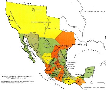
Map of Mexico, 1824

Map of Mexico, 1824

At the end of the Mexican-American War (1846-1848) the 1848 Treaty of Guadalupe Hidalgo ceded over half of Mexico’s territory to the USA. A few years later, under the 1853 Gadsden Purchase (Treaty of La Mesilla), northern portions of Sonora and Chihuahua (shaded brown on the map below) were transferred to the USA.

Mexico 1853

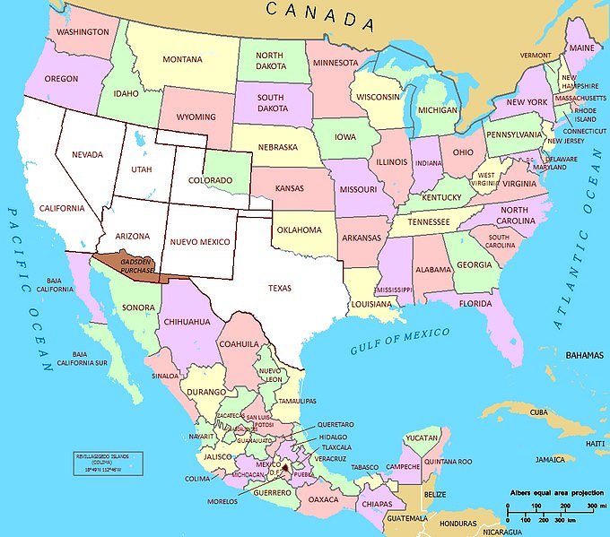
Source: National Atlas of the United States (public domain)

With minor exceptions since, to take account of changes in the meanders of the Río Bravo (Grande), this established the current border between the two countries.

Impacts on the Tohono O’odham people

One of the immediate impacts of the Gadsden purchase was to split the lands of the Tohono O’odham people into two parts: one in present-day Arizona and the other in the Mexican state of Sonora, divided by the international border. The O’odham who reside in Mexico are often known as Sonoran O’odham.

There are an estimated 25,000 Tohono O’odham living today. Most are in Arizona, but about 1500 live in northern Sonora. In contrast to First Nations (aboriginal) groups living on the USA-Canada border who were allowed dual citizenship, the Tohono O’odham were not granted this right. For decades, this did not really matter, since the two groups of Tohono O’odham kept in regular contact for work, religious ceremonies and festivals, crossing the border when needed without any problem. Stricter border controls introduced in the 1980s, and much tightened since, have greatly reduced the number of Tohono O’odham able to travel freely. This is a particular problem for the Tohono O’odham in Sonora, most of whom were born in Mexico but lack sufficient documentation to acquire a passport.

Tohono o'odhum border protest

Tohono O’odham border protest

Since 2001, several attempts have been made in the USA to solve the “one people-two country” problem by granting U.S. citizenship to all registered members of the Tohono O’odham, regardless of their residence. So far, none has succeeded.

The largest community in the Tohono O’odham Nation (the Arizona section of Tohono O’odham lands) is Sells, which functions as the Nation’s capital. The Sonoran O’odham live in nine villages in Mexico, only five of which are offically recognized as O’odham by the Mexican government.

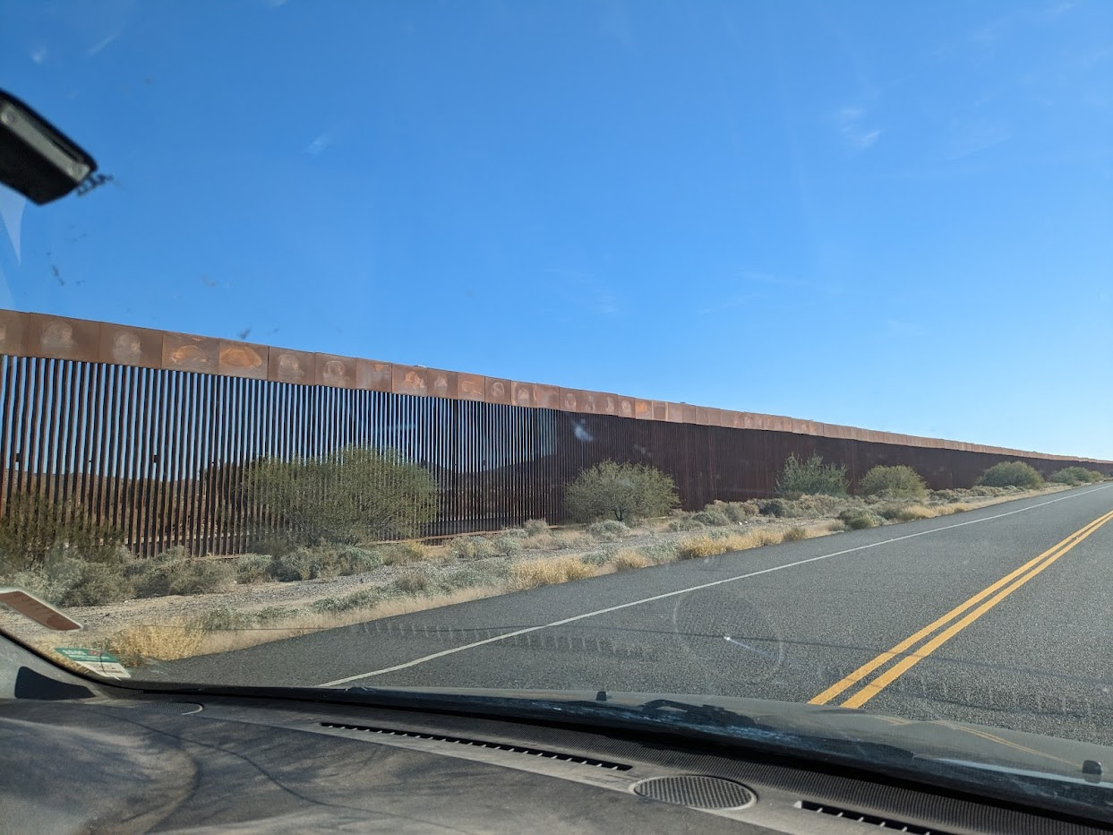
The border between the two areas is relatively unprotected compared to most other parts of the Mexico-USA border.

The Tohono O’odham Nation is often called upon to provide emergency assistance to undocumented workers (and drug traffickers) from south of the border who have underestimated the severe challenges of crossing this section of the harsh Sonora desert. Tribal officials regularly complain about the failure of the U.S. federal government to reimburse their expenses.

ABC News reports (Tohono O’odham Nation’s Harrowing Mexican-Border War) that the border “has made life a daily hell for a tribe of Native Americans” and that drug seizures on the Tohono O’odham Nation’s lands have increased sharply.

Want to read more?

  • The Sonoran O’odham lieutenant governor continues to help after 16 years
  • A story passed down from generation to generation  (Lisa Palacios, a Tohono O’odham anthropology student at the University of Arizona with relatives on both sides of the border shares her grandparents’ story)

Over half a million natives of the state of Puebla live in New York City

 Excerpts from Geo-Mexico  Comments Off on Over half a million natives of the state of Puebla live in New York City
Aug 252010
 

The New York City area is now home to over half a million poblanos, natives of the Mexican state of Puebla. A 2005 Smithsonian article by Jonathan Kandell (available here as a pdf file) takes a close look at their expectations and aspirations. Most started as undocumented workers, but many have gained legal status through the 1986 Immigration Reform and Control Act (ICRA) or a variety of other means.

The story of Ricardo and Aldea is just one example. They got to New York by crossing the 49o C (120o F) Sonoran Desert in the summer of 2003. They work 70-hour weeks for less than the minimum wage. She will pay for her month long trip back to Puebla by serving as a courier, or paquetera, a person who carries clothing, electronics, and other gifts from immigrants to their families.

Getting back and forth across the border without proper documents is more difficult than it used to be, but is not a significant problem. Most rely on trusted polleros, often called coyotes, who provide border crossing service for fees ranging from a few hundred dollars for just crossing the border to a few thousand dollars for door-to-door service.

Population pyramid for Piaxtla, 2000.

Population pyramid for Piaxtla, 2000. How does this pyramid reflect out-migration?

Migration has had a profound impact on villages in Puebla, such as Piaxtla. Most of the 1600 current residents of Piaxtla are either children or elderly (see population pyramid). The mayor claims that “maybe three out of four of my constituents live in New York”. The hundreds of millions of dollars send back each year are having a dramatic effect on rural communities in Puebla. Forty years ago, virtually all the houses were made of palm-thatch adobe. Now they are mostly brick and concrete. Many are topped with satellite dishes.

The towns also have new restaurants, taxis, video arcades, cybercafes, and newly paved streets, all made possible from remittances. Ironically, the towns are sparsely populated and many of the new houses are empty because their owners are working in New York.

Most youth consider the prospect of migration. Few think about careers in Mexico or becoming artisans and continuing Puebla’s long tradition of ceramics, woodworking and weaving. Teenagers show little interest in corn farming, the traditional mainstay of the local economy. In short, migrating to jobs in New York has become the norm.

Somewhat similar migration channels link:

For previous posts about remittances, the funds sent home by migrant workers, see:

Migration between Mexico and the USA is the focus of chapter 25 of Geo-Mexico: the geography and dynamics of modern Mexico. Ask your library to buy a copy of this handy reference guide to all aspects of Mexico’s geography today! Better yet, order your own copy…

Aug 182010
 

People in the small village of Napizaro near Lake Pátzcuaro in Michoacán are very familiar with North Hollywood, California, which is over 2400 km (1500 miles) away. Almost everyone born in Napizaro now over 20 years old is living, or has lived, in North Hollywood, which is home to at least one member of virtually every family in Napizaro.

Map showing location of Napizaro, Michoacan

Map showing location of Napizaro on Lake Pátzcuaro, Michoacán. Click to enlarge.

Initially, a few migrants from Napizaro found good jobs in North Hollywood. Through letters, phone calls and visits home, they told their friends and relatives in Napizaro and new migrants headed north. Movement between the places increased significantly. The majority of young boys and many young girls look forward to the day when they can travel to North Hollywood and start making real money. Many of the migrants from Napizaro moved their immediate families and settled permanently in North Hollywood.

Remittances sent back from workers in North Hollywood have had a big impact on Napizaro. The village has numerous impressive brick homes, with cars parked in the driveways and satellite TV dishes on the roofs. The newly built bull ring is named “North Hollywood.”

This is another example of a migration channel linking two rather distant places.  There are numerous migration channels between specific towns in Mexico and particular places in the USA.

Another migration channel links Aguililla, Michoacán, and Redwood City, California

For previous posts about remittances, the funds sent home by migrant workers, see:

Migration between Mexico and the USA is the focus of chapter 25 of Geo-Mexico: the geography and dynamics of modern Mexico. Ask your library to buy a copy of this handy reference guide to all aspects of Mexico’s geography today! Better yet, order your own copy…

Migration channels between Mexico and the USA, or how distant towns are linked through migration

 Updates to Geo-Mexico  Comments Off on Migration channels between Mexico and the USA, or how distant towns are linked through migration
Aug 132010
 

The municipality of Aguililla, Michoacán, is closely linked to Redwood City, California, over 2900 kilometers (1800 miles) away. Redwood City has about 37,000 Latino residents, perhaps half of which were originally from Aguililla. There are almost as many Aguilillans in Redwood City as there is in the municipality of Aguililla, which has about 25,000 residents. Aguililla and Redwood City are officially “Sister Cities”.

Coat-of-arms of Aguililla, Michoacán

Coat-of-arms of Aguililla, Michoacán, clearly showing the road out...

How did this linkage form?  Under the Bracero program many workers from Aguililla got temporary visas to work in California’s San Joaquin and Salinas valleys. Since agricultural work was seasonal, the immigrants looked for more permanent employment.

A number found jobs in Redwood City, just south of San Francisco. Word spread to Aguililla relatives and friends in the Bracero program. They headed for Redwood City where they got assistance in finding jobs and homes from earlier Aguilillan migrants. Many returned to their hometown and soon everyone in Aguililla learned about the good jobs and good life in Redwood City.

Before long there was a significant stream of workers leaving Aguililla headed for Redwood City.  Many early migrants became permanent and moved their families. But they retained their ties to Aguililla and made return trips from time to time so their children could learn their roots and see their grandparents. The remittances sent back from workers in Redwood City have been important to the Aguilillan economy for over 60 years.

This is an example of a migration channel which links two rather distant places. There are numerous migration channels between specific towns in Mexico and particular places in the USA.  We look at other examples in other posts.

The principle of distance decay suggests that the strength of links between settlements is usually inversely proportional to the distance between them (places close together, strong links; places further apart, weaker links). Migration channels cause anomalies in this pattern, since they often lead to strong spatial interactions which do not match those expected from distance decay.

For previous posts about remittances, the funds sent home by migrant workers, see:

Migration between Mexico and the USA is the focus of chapter 25 of Geo-Mexico: the geography and dynamics of modern Mexico. Ask your library to buy a copy of this handy reference guide to all aspects of Mexico’s geography today! Better yet, order your own copy…

Oil in the Gulf of Mexico (Canwest headline writers take note).

 Mexico's geography in the Press  Comments Off on Oil in the Gulf of Mexico (Canwest headline writers take note).
Mar 262010
 

Inaccuracies involving Mexico occur all too frequently in the press. This is the first of an occasional series recording such Mexico-related imprecisions.

Canwest News Service claims to be “the best source in Canada for editorial content because we have more journalists than any other organization.” Maybe its journalists are better than its headline writers.

The evidence? Canwest’s report (20 March 2010) about a recent oil discovery by Shell in the Gulf of Mexico, headlined Mexican oil find ‘significant’. Apparently, Canwest’s headline writers do not realize that much of the Gulf of Mexico is not actually Mexican. A more accurate title for the Canwest story would have been US oil find ‘significant‘.

The USA and Mexico share the Gulf, with periodic arguments about the precise offshore limits of each country’s jurisdiction. A few years ago, it was alleged, probably without foundation, that the USA was already  “sucking the oil” out from joint oil fields that straddled the divide.

What is certain is that the USA has encouraged the development of oil fields in relatively deep water (more than 500 meters deep or 1,640 feet) in the Gulf, which require advanced deep-water drilling techniques, and the expertise of Shell and other multinational oil firms.

However, in Mexico, all oil exploration in managed by state-owned oil giant Petroleos Mexicanos (Pemex). Mexican experts believe that up to 29.5 billion barrels of oil might reside in Mexico’s share of the Gulf, but Pemex has little to show for 7 years of deep water drilling apart from some relatively minor gas finds.

Only a few days before the Canwest story, though, Pemex did announce two  important new finds in shallow waters in the Gulf of Mexico. Ayatzil-Tekel, found in 2008, holds a total of one billion barrels of proven, probable and potential (3P) reserves of super-heavy crude. Tsimin-Xux, found last year, has a similar amount of super-light crude.

Mexico’s total 3P reserves now stand at about 46 billion barrels, which would last more than 40 years at current rates of extraction.