Update (14 July 2014):
Civil Protection groups in Chiapas report that a total of 9,000 homes in that state were damaged by the 6.9 magnitude earthquake that struck the region on 7 July 2014 (see below). Three people lost their lives as a result of the ‘quake: two in Hixtla and the other in Mapastepec.
Minor damages have been reported for various public buildings including the Town Hall in Tapachula, primary schools in Tapachula and Tuxtla Chico, two health care centers in Villacomaltitlán and the municipal market in Escuintla.
While all highways remained open to traffic, minor highway damages were reported on several roads including:
- the road connecting Unión Juárez to Talquián, Córdova and Chiquihuites
- the road linking Huixtla to El Jocote
A total of 38 municipalities in Chiapas have now been formally declared “Disaster Areas” which gives them access to funds from the federal Natural Disaster Fund.
The municipalities are Acacoyagua, Acapetahua, Amatenango de la Frontera, Arriaga, Bejucal de Ocampo, Bella Vista, Cacahoatán, Chicomuselo, El Porvenir, Escuintla, Frontera Comalapa, Frontera Hidalgo, Huehuetán, Huixtla, La Grandeza, Mapastepec, Mazapa de Madero, Mazatán, Metapa, Montecristo de Guerrero, Motozintla, Pijijiapan, Siltepec, Suchiate, Tapachula, Tonalá, Tuxtla Chico, Tuzantán, Unión Juárez, Villa Comaltitlán, Altamirano, Ángel Albino Corzo, Comitán de Domínguez, El Parral, La Concordia, Tuxtla Gutiérrez, Villa Corzo and Villaflores.
Original post (7 July 2014):
A strong earthquake has rocked Mexico’s southern state of Chiapas and the neighboring San Marcos region of Guatemala. There are two reported fatalities in Chiapas, while in Guatemala casualties were restricted to a new-born baby, tragically killed by falling debris. About 300 homes in 15 municipalities in Chiapas are reported to have been damaged.
The earthquake, at about 6:30 am local (Chiapas) time, registered 6.9 on the Richter scale, though the US Geological Survey had earlier reported it as magnitude 7.1. The epicenter of the earthquake was 2km north-northeast of Puerto Madero, Chiapas, very close to Tapachula.
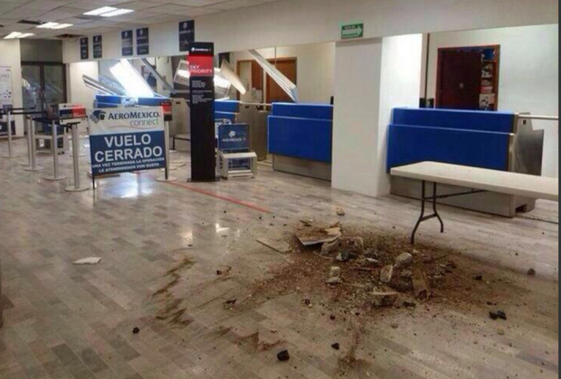
The airport of Tapachula, close to the Mexico-Guatemala border, is now reported to be operating normally, having sustained minor damages (see below) and having been briefly closed for inspection, with no flights allowed to land or take off.
A sequence of images posted by Mexico City daily Milenio shows some of the damage and devastation caused by the earthquake.
Damage is also reported to many homes in Tapachula, and the town market in Huixtla (north-west of Tapachula) has been partially closed due to structural damage.
We will update this report as more information becomes available.
Related posts:
- Which tectonic plates affect Mexico?
- How has the movement of tectonic plates affected Mexico?
- Major earthquake strikes Guerrero and Oaxaca states (20 March 2011)

Sorry, the comment form is closed at this time.