The revitalization of Mexico City’s historic downtown core.

 Excerpts from Geo-Mexico  Comments Off on The revitalization of Mexico City’s historic downtown core.
Aug 172010
 

The Historic Center of Mexico City was originally founded in 1524 atop the Aztec capital of Tenochititlan. The Historic Center declined considerably during the 20th century. The government froze rents in the 1940s and they stayed frozen until 1998. With constant inflation, the real price of rents declined to almost nothing.
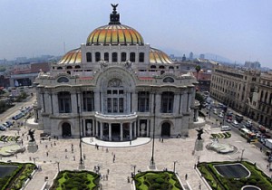
Bellas Artes opera house, Mexico CityWithout meaningful rental incomes, landlords abandoned or stopped maintaining their properties. Buildings and neighborhoods decayed. Once-fancy communities became slums. Many wealthy and middle class residents as well as commercial establishments moved out to suburbs. The National University (UNAM) moved to a new purpose-built campus in the south.

The tragic earthquakes in September 1985, the first measuring 8.1 on the Richter scale, hit many badly maintained downtown areas particularly hard. More and more residential buildings were abandoned as insecurity, pollution and decay set in, aided and abetted by the sinking ground levels due to aquifer depletion.

At the start of the 21st century, a government-private sector Historic Center Trust was formed to buy and systematically rehabilitate dozens of centuries-old buildings and breathe new life into the city center. Investment in the revitalization effort was over $500 million and has created 15,000 new jobs.

Drainage and water systems were replaced. Electric and telephone cables were buried below ground. The facades of more than 500 buildings on 13 streets were carefully restored. Streets were repaved and pedestrianized. Plazas came back to life; new museums sprung up; street vendors were relocated. Cafes and restaurants opened, giving new focal points for residents and tourists alike.

If you have enjoyed this brief excerpt from chapter 23 of Geo-Mexico: the geography and dynamics of modern Mexico please consider purchasing your own copy of the book. Chapters 21 and 22 analyze Mexico’s 500-year transition to an urban society and the internal geography of Mexico’s cities. Chapter 23 looks at urban issues, problems and trends. To preview more parts of the book, click here and use amazon.com’s “Look Inside” feature
Air quality improving in Mexico City but not in Monterrey

 Mexico's geography in the Press, Other  Comments Off on Air quality improving in Mexico City but not in Monterrey
Aug 102010
 

A recent short piece in The Economist, “A breath of fresh air” (31 July 2010) echoes Geo-Mexico’s contention that air quality has been improving in Mexico City in recent years, but declining in other large cities, especially Monterrey.

The improving air quality in Mexico City is attributed to:

  • relocation of heavy industry away from the city
  • closure of the Azcapotzalco oil refinery (1991); part of this area is now a public park
  • vehicle emissions standards, and enforcement
  • “Día sin coche” (Day without a car) policy for all but the newest vehicles
  • improvements to public transport, such as introducing Metrobus; starting in 2011, taxi owners have incentives to use hybrid or electric vehicles
  • on-going, effective monitoring of air quality since the mid 1980s
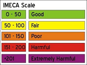
The IMECA scale for urban air quality

The IMECA scale for urban air quality

Air quality still exceeds environmental norms in Mexico City many days each year, but far fewer than during the late 1980s and early 1990s when air pollution was at its peak. Even low-level ozone measurements are showing improvement. Ironically, ozone in the lower atmosphere rose immediately after the introduction of a new unleaded gasoline, designed to  ensure that the major source of brain-damaging lead pollution was removed. The new gasoline, it emerged, simply traded one serious pollutant for another.

Latest pollution values for Mexico City.

Mexico’s other big cities still face enormous challenges with regards to air pollution. Monterrey’s air regularly has very high concentrations of microparticulates (PM10); the levels now exceed Mexico City’s peak readings from twenty years ago.  The air in Guadalajara is improving, but not as rapidly as in Mexico City.

Geo-Mexico: the geography and dynamics of modern Mexico examines the trends in air quality (ozone, microparticulates and carbon monoxide) for Mexico’s three largest cities and also asks whether the air pollution from maquiladora plants in Ciudad Juárez raises public health issues.

Ask your library to buy a copy of this handy reference guide to all aspects of Mexico’s geography today! Better yet, order your own copy…

Previous post on this topic: Mexico City air quality continues to improve

Aug 062010
 

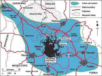
The rapid spatial expansion of Mexico City is not slowing down in the 21st century but accelerating. The main stimulus of this sprawl is income growth, which leads to widespread ownership of private automobiles and the desire of Mexican families to own homes. The number of automobiles in Metropolitan Mexico City (ZMCM) is approaching 10 million, almost double the number in 2000. Most households have access to a private car, many have several cars. Automobiles are responsible for nearly half of all trips. While the 2008–2009 economic downturn dramatically reduced new car purchases, the market has picked up significantly in 2010.

Map of Mexico City urban system

Map of Mexico City urban system. Click to enlarge. All rights reserved.

New suburban residential developments for all income levels now stretch up to 40 km from the Zócalo (the main plaza in Mexico City’s center).  Some developers sell undeveloped lots; others build family homes. Most of these new developments are in gated communities and are focused on car-owning buyers.

A case can be made that Mexico City is beginning to merge with surrounding urban areas (see map) into a “super city” or megalopolis, with a total population of about 30 million.

The eastern border of the Toluca Metropolitan Area (population 1.6 million) is the Federal District. The Cuernavaca urban area (population 788,000) is only about 20 minutes south by toll road. The western edge of Metropolitan Puebla-Tlaxcala (population 2.1 million) is only about 30 minutes from the eastern edge of Greater Mexico City. Pachuca (population 278,000) is only about 30 minutes north.

A megalopolis is one possible future scenario for Mexico City.

If you have enjoyed this brief excerpt from chapter 23 of Geo-Mexico: the geography and dynamics of modern Mexico please consider purchasing your own copy of the book. Chapters 21 and 22 analyze Mexico’s 500-year transition to an urban society and the internal geography of Mexico’s cities. Chapter 23 looks at urban issues, problems and trends. To preview more parts of the book, click here and use amazon.com’s “Look Inside” feature.

Bringing place names to life in Mexico City

 Books and resources  Comments Off on Bringing place names to life in Mexico City
Aug 022010
 

I love gifts, especially books, and especially when they are related to the geography of Mexico!

So, it was a doubly pleasant surprise recently to receive a copy of Glifos de la ciudad de México by Pablo Moctezuma Barragán (Gobierno del Distrito Federal, 2006; 103 pp.)

The author is an accomplished researcher, historian and politician who holds a teaching position at the Azcapotzalco campus of the Universidad Autónoma Metropolitana, and who spearheaded a campaign in Mexico City to bring the meanings of place names to life.

Atocpan = "On fertile soil"

Atocpan = "On fertile soil"

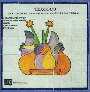
The project involved the installation around the city in 2006 of more than 300 works of art, all using traditional Talavera tiles, depicting pre-Hispanic glyphs, together with a brief explanation of their derivation and meaning. Each mosaic of 25 tiles measures one meter by one meter.  The vast majority of the glyphs are depicted as they are known in ancient codices or other historic sources, but in a few cases, glyphs have been specially created, faithfully reflecting  the ancient principles. Glifos de la Ciudad de México is a handy pocket guide to these glyphs.

The obligatory introductory statements by politicians are mercifully brief, though significantly for us, they do refer to the fact that many names depend on a circunstancia geográfica (a geographical circumstance) or are related to activities undertaken by the early settlers or to characteristic plants or animals. How encouraging to see such a tribute to geography!

Next comes a very interesting essay by Pablo Moctezuma Barragán, setting the scene for the full color illustrations of hundreds of glyphs which follow. The author discusses the origins of place name glyphs (the oldest date back 2500 years), and emphasizes that many reflect the importance of local geographic conditions. The forces of globalization may be at work in what is arguably the world’s largest city, but “It is important to rescue our roots”, argues Moctezuma Barragán, “We should not live like foreigners in our own land”.

He goes on to summarize the Nahuatl roots of many of the names and gives a potted history of the development of Mexico City.

Tile mosaic depicting glyph of Texcoco

Tile mosaic depicting glyph of Texcoco ("in the place where plants grow on rocks") on a wall in Mexico City. Credit: Glifos de la ciudad de México.

All the glyphs refer to names used somewhere in the city and many photographs show the commemorative tiled versions in situ in the city. In all, 322 glyphs were installed, and more than 220 of them are included in this book.

This is but one example of the many projects undertaken by Mexico City authorities in recent years to beautify the city.

What a neat idea, to introduce people, even as they go about their daily lives, to pre-Hispanic symbolism as it relates to local place names. These tiled works of art are a great way to encourage a sense of place and identity. They are not only beautiful, they serve to foment local pride.  Geography is alive and well in Mexico City!

Related website.

Several hundred ancient glyphs, from Antonio Peñafiel’s 1885 “Nombres Geográficos de México,” can be viewed online as part of the Aztec Place Name Glyphs Project of the Department of Geography at the University of California, Berkeley.

Previous posts about Mexico’s place names:

Jul 082010
 

Mexico City’s inner city slums date from the regime of Porfirio Díaz (1877–1910) which stimulated rapid railroad expansion and industrialization north and northwest of the city center. The industrial zone expanded out along the rail lines into the areas now known as Azcapotzalco and Gustavo A. Madero.

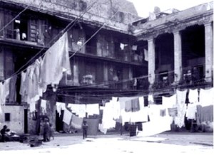
Typical vecindad, Mexico CityWith this expansion, the upper classes sold or abandoned their inner city colonial mansions and moved further west, deliberately avoiding noisy and polluted industrial areas. Their abandoned multi-storied mansions were converted into vecindades, cheap tenements with individual rooms rented to families.

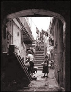
Vecindades, with a shared central court, kitchen and latrines, became Mexico City’s first slums. They encircled the center on the north, east and south; the west side remained upscale. As these eventually became overcrowded, incoming migrants moved into cheap, undesirable housing in the industrial zone or on the urban periphery.

Vecindad, Mexico CityRapid industrialization after World War II brought another massive wave of poor immigrants. They initially headed for the low rent vecindades which had expanded as developers built new tenements using the old vecindades as a model.

Following government-mandated rent control, many investors abandoned the vecindades, depleting an already poor housing stock. Affordable housing emerged as a paramount concern of low-income residents; most were forced into colonias populares either on very steep hillsides or the urban periphery, such as Nezahualcoyotl.

While vecindades are most closely associated with Mexico City, they also emerged in Mexico’s other large cities. About ten percent of Mexico City’s current residents live in vecindades.

Mexico’s cities and towns are analyzed in chapters 21, 22 and 23 of Geo-Mexico: the geography and dynamics of modern Mexico. Buy your copy today!!

Mexico City’s wholesale food market, Central de Abasto

 Books and resources, Other  Comments Off on Mexico City’s wholesale food market, Central de Abasto
Jul 072010
 

Have you ever wondered how food supplies are organized in a metropolitan area the size of Mexico City (population 20 million) so that all its inhabitants have regular access to fresh produce? Like most major world cities, Mexico City has a specialized wholesale market for food, Central de Abasto. It is located in Iztapalapa, south-east of the city center.

Nicola Twilley, a freelance writer currently based in Montreal, has written a wonderfully informative description of what a visit to the Central de Abasto is like on her fascinating blog edible geography

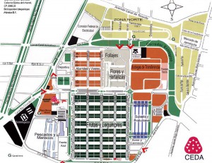
Map of Central de Abasto, Mexico City

Map of Central de Abasto, Mexico City. Click to enlarge.

The map is the “official” map of the Central de Abasto in all its glory. While I often organized market surveys for school groups in Mexico, I have to admit that I never dared take on the challenge of surveying the Central de Abasto. This map, and Twilley’s fun account of the market reminds me why I never had the courage!

Mexican markets, in all their guises, from the massive Central de Abasto down to a humble tianguis (street market) in a small village, are a fascinating aspect of Mexico’s geography, and well worth a book in their own right.

Enjoy!

Notes: