Oct 042010
 

The map shows the coasts of the states of Colima, Jalisco and Nayarit. These states all have some great beaches, and tourism is an important activity in many of the towns shown on the map. Some of the beaches are so exposed that the Pacific Ocean waves arriving to smash into the sand offer outstanding surfing opportunities. Other beaches are more sheltered, with calmer waters perfect for swimming.

Map of Pacific Coast beaches. Copyright 2010 Tony Burton. All rights reserved.

Besides being important for tourism, Manzanillo is one of Mexico’s largest ports. One of the major reasons why the port of Manzanillo has attracted so much investment in recent decades is that it is easy to access via the major divided highway to/from Guadalajara and the interior of Mexico (and indeed, the US border).

Further north, San Blas was once an important port, but declined as silting blocked the shallow access routes. We described the historical geography of San Blas in a previous post:

Barra de Navidad also had great historical importance, as one of the shipbuilding ports where the Spanish built the ships which traversed the Pacific Ocean to the islands of the Philippines.

The coast around the headland of Punta de Mita used to be the site of rustic fishing villages, from where fisherman also took occasional groups of tourists out to sea whale-watching. This headland, and these villages became one of the best recent examples in Mexico of a forced migration:

In recent years tourism developments have caused more forced relocations than dam construction. One example is the Punta de Mita peninsula, 50 km (30 mi) north of Puerto Vallarta, developed in the 1990s. The existing residents, mostly fishermen, were forced from their homes on the coast so that their ejido lands could be converted into a luxury tourist resort and Jack Nicklaus-designed golf course.

The fishermen were moved from their breezy and somewhat ramshackle palapa huts, interspersed with palm trees, into ugly, concrete block houses a short distance inland, in the purpose-built small town of Emiliano Zapata, which adjoins a redeveloped coastal commercial/ restaurant strip called Anclote. Attempts by the developers to build the fishermen a small boat-building workshop and breakwater to protect the beach caused sand to be eroded from one of the only two remaining beaches with public access. During the resort’s construction an influx of workers from other parts of Mexico pushed prices up and led to social problems. (Geo-Mexico: the geography and dynamics of modern Mexico page 191)

More dramatic changes are now underway along part of this coastline. The area north of Sayulita (which has become a favored wintering location for Americans and Canadians) as far as the beach resort of Rincón de Guayabitos (favored by Mexican families) is slowly being transformed into Mexico’s latest purpose-built tourist resort, in the same way that other Mexican mega-resorts such as Cancún, Huatulco and Ixtapa were created.

Only time will tell what eventually happens to the areas that currently remain as genuine wilderness coast. One thing is sure – the more we develop this coastline, the more ecological damage will be done in the name of progress. Ecologically productive mangroves have been stripped out almost all along the coast, giving way to luxury hotels and marinas. Mangroves are now protected by federal law, but enforcement of this law may not be very effective.

Equally, fewer safe places now remain for the various endangered species of marine turtles who first visited these beaches a very long time before even the early Spanish mariners. One good sign is that active turtle protection programs exist at several of the beaches in this area. Ecological education is a good thing; ecological action is even better.

For more information about the geography of Mexico, buy your copy of Geo-Mexico: the geography and dynamics of modern Mexico today!

 Tagged with:

Map of the state of Quintana Roo, with Cancún, Cozumel and Tulum

 Maps  Comments Off on Map of the state of Quintana Roo, with Cancún, Cozumel and Tulum
Sep 272010
 

The state of Quintana Roo (see map below) has an area of 42,360 square kilometers and a population of 1,361,821 (2010 estimate). The state is one of Mexico’s flattest states, with its highest point being only 230 meters above sea level. Its distinctive landscapes include coastal barrier islands (such as the one Cancún’s hotel  zone is built on), magnificent coral reefs and tropical karst (limestone scenery). It also has tropical forests and mangrove swamps. The state’s capital city  is Chetumal (estimated 2010 population: 146,000), an important port and the gateway for overland connections to Guatemala. A short distance north of Chetumal is the beautiful, tranquil Laguna Bacalar.

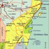
Map of Quintana Roo. Copyright 2010 Tony Burton. All rights reserved.

Until the mid-20th century, the state was best known for its chicle (used for chewing gum) collectors and its Mayan ruins. Many of these have been restored in the past 50 years or so, and are now important tourist attractions. The best known sites are Tulum perched on a cliff overlooking the azure Caribbean sea (and unfortunately all too accessible for cruise ship passengers) and Cobá, a magnificent city only partially cleared of jungle. Ecotourism is an important sector of tourism in Quintana Roo. Critics notwithstanding, one of the most memorable eco-related sites in the entire country is Xcaret marine park. The biosphere reserve of Sian Ka’an in the middle part of the state also draws large numbers of  ecotourists.

The purpose-built resort of Cancún, begun in 1970, has grown into Mexico’s most important tourist resort. Easily reached by plane from most parts of the USA, Canada and Europe, it is one of the world’s major destinations for package holidays. The area south of Cancún is often referred to as the Mayan Riviera; it is one of Mexico’s most rapidly developing tourist areas.

Previous post related to Quintana Roo

Maps of neighboring states

Geo-Mexico: the geography and dynamics of modern Mexico looks at many aspects of Quintana Roo, including its socio-economic make-up and its development indicators. If you are interested in the geography of Mexico, please recommend this book to your local library or consider buying your own copy, as well as following this site with details of all new posts via  e-mail, Facebook or Twitter.

The 10 largest states in Mexico in terms of population

 Other, Teaching ideas  Comments Off on The 10 largest states in Mexico in terms of population
Apr 062010
 

This table shows the ten states in Mexico which have the largest populations. The total population was 112,322,757 in 2010, according to the preliminary results of the 2010 census. These figures may change slightly when the final results of the census are made available.

RankStatePopulation (2010 census)
1State of México15,174,272
2Federal District8,873,017
3Veracruz7,638,378
4Jalisco7,350,355
5Puebla5,779,007
6Guanajuato5,485,971
7Chiapas4,793,406
8Nuevo León4,643,321
9Michoacán4,348,485
10Oaxaca3,801,871

Q. Find these ten states on a map of Mexico [printable map of Mexico in pdf format]. Do the states with the most people also have the largest land areas?

“La Curva de la Gringa”, the American woman’s curve, a place name in Michoacán, Mexico

 Maps, Mexico's geography in the Press, Other  Comments Off on “La Curva de la Gringa”, the American woman’s curve, a place name in Michoacán, Mexico
Mar 302010
 

Another interesting example of an unusual place name (following on from an earlier post about unusual place names) is the name “La Curva de la Gringa”, the American woman’s curve.

La Curva de la Gringa is the name of a 90-degree bend near Jungapeo, west of Zitácuaro in the state of Michoacán. Literally translated as “the American woman’s curve”, how did this name come about? The first thing to remember is that all names on maps have to come from somewhere. Detailed maps of Mexico, including the 1:50,000 series, relied initially on aerial (later satellite) imagery, followed by some checking on the ground. Given the expense, ground checking was often relatively limited. However, the on-the-ground surveyors were responsible for adding names to the maps.

La Curva de la Gringa, Michoacán (on Mexico’s 1:50,000 topographic map)

In this case, local informants were apparently unanimous in calling this bend La Curva de la Gringa. Further research shows that this had nothing to do with any purported similarity to the sensuous curve of a gringa‘s breast, but derived from when the road was first paved in the 1950s. Apparently, shortly after the road was finished, an American lady driving her oversized gas-guzzler down to the luxury spa of San José Purua completely missed this bend, and plowed into a cornfield. The locals have long memories!

In 2010, this road is being widened, and sidewalks and street lights installed, all the way from Federal Highway 15 (see map), past La Curva de la Gringa, and as far as the money allocated (currently about 7 million pesos) allows. The first section was due to be inaugurated 21 March 2010. If anyone has an update, please leave a comment. Here’s hoping that no more accidents ever occur along this stretch of road, and that no future place names ever reflect such unfortunate incidents.

First map of Mexico on postage stamp

 Maps, Other  Comments Off on First map of Mexico on postage stamp
Mar 142010
 

It was not until 1915, in the middle of the Mexican Revolution, that a map of the Republic appeared for the first time as the central design on a Mexican postage stamp.

Most states were named, though abbreviations were necessary given the size of the stamp. In 1915, though, the state of Nayarit on the Pacific Coast, north-west of Colima did not yet exist. It came into being in1917, with the signing of Mexico’s Constitution (the one which is still currently in force). Baja California, shown as single entity on the map, was divided into northern and southern sections in 1931.

In addition to the states, the map shows the main railway lines and also the main shipping routes. In 1915, the easiest way to reach the Yucatán Peninsula was by boat. It would be another 35 years or so before a rail link was completed between Veracuz and Merida. International shipping routes were very important in 1915, since air travel was in its infancy.

The map take some artistic license with scale. In particular, the island of Cuba has been brought much closer to the north-eastern tip of the Yucatán Peninsula than it really is.

The historical evolution of the boundaries of Mexico, and of its individual states, are analyzed in chapter 12, “The changing political map of Mexico” of Geo-Mexico: the geography and dynamics of modern Mexico. The development of Mexico”s railway lines is discussed in detail in chapter 17.