A 1902 travel account, and unexpected link between Mexico and a Swiss castle

 Books and resources  Comments Off on A 1902 travel account, and unexpected link between Mexico and a Swiss castle
Feb 252016
 

Dr Carl Wilhelm Schiess (1869-1929) is the unexpected link between Mexico and a Swiss castle. Schiess wrote a travel account, first published in 1902, of a two-month trip in Mexico in the winter of 1899-1900. The account, only ever published in German, is Quer durch Mexiko vom Atlantischen zum Stillen Ocean (“Across Mexico from the Atlantic to the Pacific Ocean”), published in Berlin by Dietrich Reimer.

Early travel accounts of Mexico are a valuable source of information for historical geographers, as well as for armchair travelers. Schiess’s account is no exception.

Who was Carl Wilhelm Schiess?

Carl Wilhelm Schiess of Basel and Herisau was born on 12 July 1869. His father was Prof. Dr. Heinrich Schiess, a well-known ophthalmologist in Basel, and his mother Rosalie Gemuseus. After completing his medical studies, the young doctor traveled abroad. These travels included  a trip with his brother to Mexico over the winter of 1899-1900.

Where did they travel in Mexico?

They entered Mexico (and returned) via New Orleans. The brothers traveled by rail to Torreón, and then to Durango, before crossing the Western Sierra Madre to Mazatlán. From Mazatlán, they took a steamer to San Blas, and then proceeded to cross the country from west to east, via Tepic, Tequila, Guadalajara, Chapala, Zamora, Uruapan, Pátzcuaro, Morelia, Mexico City, Amecameca, to Veracruz, before returning north via Orizaba, Cordoba, Guanajuato, Aguascalientes and Zacatecas. Quite the itinerary to complete in just two months!

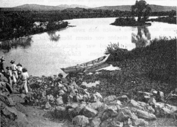
They were very impressed by the grandeur of the Juanacatlan Falls and the book includes several photographs of that area, including the falls themselves, women washing clothes below the falls, and this photo of an unpolluted River Santiago (aka Rio Grande) immediately before the falls.

Wilhelm Schiess: Rio Grande, Juanacatlan (December 1899)

Wilhelm Schiess: Rio Grande, Juanacatlan (December 1899)

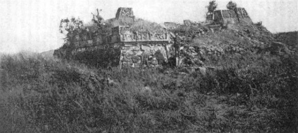
Schiess and his brother had plenty of adventures along the way. Like most other early travelers in Mexico, they made a point of climbing Popocatepetl Volcano, but the brothers went one better than most and photographed the interior of its crater. The two men made several trips to places, such as mines, that were well off the beaten track. In central Mexico, they took the time to explore the ruins of Xochicalco, an archaeological site that even today is often ignored by passing tourists. The main pyramid at that time (photo) had not been restored.

Wilhelm Schiess: Xochicalco (December 1899)

Wilhelm Schiess: Xochicalco (December 1899)

Schiess’ account of their travels in Mexico is essentially a factual, straightforward account of their impressions and what they did, with few digressions, more of a journal than a modern-day travel book. It was well received at the time as an accurate, first-hand account of several little-known parts of Mexico.

A review in the Bulletin of the American Geographical Society claimed that, “His route from Durango across the Sierra Madre to Mazatlan has perhaps never been described before, and the interesting regions he crossed between San Blas and Lake Chapala are not well-known.” It probably is unlikely that the Durango-Mazatlan route had been described in detail prior to Schiess, though (by coincidence) Carl Lumholtz’s Unknown Mexico, which covers some of the same ground, and was based on travels between 1890 and 1900, was also first published, like Schiess’s book, in 1902.

However, the reviewer’s claim that the “regions” between San Blas and Lake Chapala were not well known is a clear exaggeration, since there had been several earlier, detailed, first-hand descriptions of the route from San Blas via Tepic to Guadalajara (and Lake Chapala) on account of this being a major trading and smuggling route during the nineteenth century.

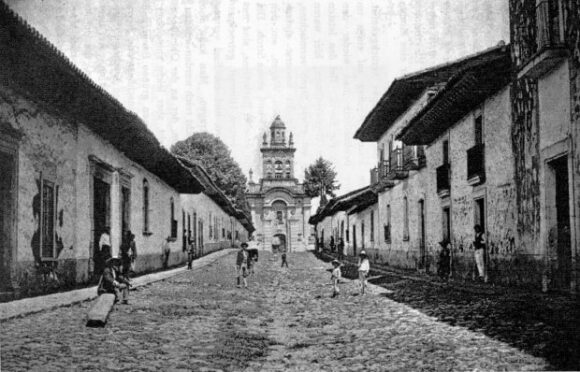
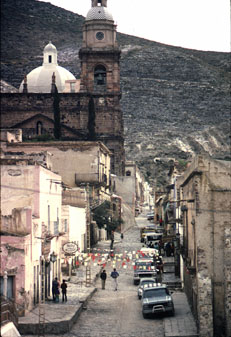
Wilhelm Schiess: Street in Patzcuaro (December 1899)

Wilhelm Schiess: Street in Pátzcuaro (December 1899)

While one reviewer of Schiess’ book lamented the lack of reference to any earlier writers, all agreed that the inclusion of 71 photographs, many of high quality, made the book a valuable addition to the existing literature about Mexico.

Sadly, and presumably because the book was never translated into any other language, Schiess’s work has never received very wide attention. [If any German-speaking reader has time on their hands, and wants to undertake a worthwhile project,… then get in touch!]

Schiess’s account of Mexico is interesting in its own right, but his personal story after the trip to Mexico is just as interesting.

Scheiss’s connection to a Swiss castle

In 1900, shortly after his return to Switzerland, Schiess’s aunt, Mrs. Rosina Magdalena Gemuseus, bought Spiez Castle, on Lake Thun in the Swiss canton of Bern. Parts of the castle date back to the tenth century.

On 28 July 1900, Schiess opened his medical practice – in the castle. Announcing in a local newspaper that his practice was now open at Spiez Castle, with office hours daily in the morning to 11 clock, and with a clinic for eye diseases on Tuesday and Friday mornings, Schiess practiced and lived in the castle for many years, though it is not known which living spaces were used by either his aunt, or the doctor and his wife.

The village of Spiez grew rapidly after 1900. Roads were improved and villagers added a new stone church and many new homes. In about 1906, Dr. Schiess commissioned a firm of Basel architects to build him a large home in the village, to house both his family and his medical office. In other respects, Schiess lived quite modestly, continuing to make his rounds to visit patients by bicycle. Contemporaries described Schiess as a friendly, helpful and keen doctor, who, during the terrible 1918 flu epidemic, worked tirelessly, with no breaks, for several months.

In 1907, Schiess’s aunt sold him some of the outlying castle properties, including the old church, rectory, manager’s house, cherry orchard, vineyards and an area of forest. After his aunt’s death on 3 February 1919, the castle itself passed to Schiess. However, the upkeep was costly, and Schiess soon found himself having to sell valuable objects from the castle to pay for its ongoing maintenance.

By 1922, Schiess was actively looking for potential purchasers. A group of villagers established a foundation with the idea of preserving the castle for future generations. On 1 August 1929, the Spiez Castle Foundation and Schiess agreed terms for the sale of the castle. Barely two weeks later, on 14 August 1929, Schiess died unexpectedly of heart failure.

The castle and gardens first opened to the public in June 1930. The castle rooms are now used for conferences, concerts, exhibitions and other events.

Source:

  • Alfred Stettler. 2004. “75 Jahre Stiftung Schloss Spiez: Die Anfänge” (“75 years of the Spiez Castle Foundation: The beginnings”) in Jahrbuch: vom Thuner und Brienzersee, 2004 (“Yearbook of the lakes Thun and Brienz, 2004). Uferschutzverband Thuner- und Brienzersee.
Mexico has seven of the world’s 100 best hotels

 Mexico's geography in the Press  Comments Off on Mexico has seven of the world’s 100 best hotels
Jan 262015
 

A survey of more than 75,000 Condé Nast Traveler readers placed seven Mexican hotels in the world’s top 100.

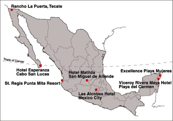
Location of Mexico's Top Seven Hotels

Location of Mexico’s Top Seven Hotels

Mexico’s top hotel (#15 in the rankings) was the Viceroy Rivera Maya hotel, in Playa del Carmen (Quintana Roo). It was joined in the top 100 by Rancho La Puerta in Tecate (Baja California), St. Regis Punta Mita Resort (Nayarit), Las Alcobas hotel (Mexico City), Hotel Matilda in San Miguel de Allende (Guanajuato), Hotel Esperanza in Cabo San Lucas (Baja California Sur) and the Excellence Playa Mujeres (Quintana Roo).

In related news, Grupo Posadas is investing one billion dollars over the next three years to open 49 new hotels, many of them in the firm’s Fiesta Americana chain. Meanwhile, at the opposite end of the hotel spectrum, Motel 6, the “McDonald’s of the hotel industry”, which has 1,200 locations in the USA and Canada, is opening 30 hotels in Mexico within the next three years.

The operator of the Motel 6 chain, G6 Hospitality, will introduce both its brands: Motel 6 and Estudio 6 (designed for extended stays) during its first foray into Latin America. The first of the new hotels will open in Salamanca (Guanajuato) in late-2015, with additional locations to follow, including Mexico City, Monterrey and several resort destinations.

Related posts:

The resort city of Cancún continues to grow

 Updates to Geo-Mexico  Comments Off on The resort city of Cancún continues to grow
Apr 232014
 

The resort of Cancún in Quintana Roo is celebrating its 44th birthday this year. Local officials have arranged a series of events between 19 and 27 April, including an exhibition of vintage cars, to mark the occasion.

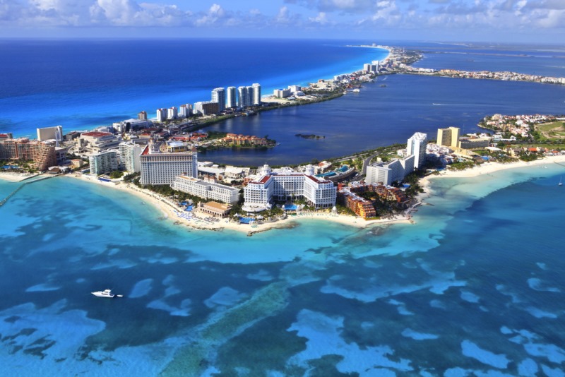
The construction of the purpose-built resort Cancún, planned by the Federal Tourism Development Agency FONATUR, began in 1970:

The tourist part of the city has thrived. Cancún now has more than 3000 condominium units, luxury shopping centers, restaurants, museums, discos, bars, an international airport and more than 150 hotels, with 35,087 hotel rooms.

In 2013, some 14 million visitors passed through the airport. Hotels had a profitable 2013, with an average room occupancy of 77.2%. Visitors to Cancún contributed an estimated 4.36 billion dollars to the local economy. Tourism provides direct employment in Cancún for around 52,600 people, and indirect employment for 175,000.

Cancún by Arthur Gonoretzky (Flickr)

Cancún by Arthur Gonoretzky (Flickr)

There is a less rosy side to Cancún. Besides the obvious adverse impacts of so many tourists, there are many other issues arising from the extraordinarily rapid growth of tourism in this area. For example, see Beach erosion in the tourist resort of Cancún, Mexico.

For a fuller discussion of the issues associated with 40 years of tourist development in Cancún, see “Ending a Touristic Destination in Four Decades: Cancun’s Creation, Peak and Agony“, which appeared in a 2013 special issue of the International Journal of Humanities and Social Science.

Tourism aside, perhaps the biggest single issue is in the “regular” city of Cancún (as opposed to the tourist zone). Cancún city (2010 population: 628,000, but sometimes claimed now to be more like 800,000) is where most supporting services are located, and most workers live. The city has grown so fast that it lacks sufficient services and fails to offer a good quality of life for its residents.

Related posts:

Mar 242014
 

According to Eduardo Barroso, the CEO of management consultancy EB Turismo, in his presentation at the XII Foro Nacional de Turismo held in Mérida, Yucatán, in February 2014, Mexico’s 83 Magic Towns (Pueblos Mágicos) attracted more than 4 million visitors in 2013, and tourist spending of more than 6 billion pesos (460 million dollars). However, he also pointed out that the program has not been prudently and carefully developed, but has been distorted by the designation of 46 Magic Towns in just two years (2011 and 2012), compared to the designation of just 37 Magic Towns in the preceding decade. (The Magic Town program started in 2001.)

Magic TownsThe Tourism Secretary Claudia Ruiz Massieu has called a halt to the program while officials work out how to reinstate it in a manner that will ensure that only towns worthy of the designation can actually acquire the status. This will no doubt require establishing new guidelines and regulations governing the program.

Success stories for the Magic Town program include San Miguel de Allende, which was first designated a Magic Town but has since been elevated to the much more exalted status of a World Heritage City;  Real de Catorce, in San Luis Potosí, which has seen visitor numbers jump by 1200% in only 12 years; and the town of Tequila, in Jalisco, where the coordination of three levels of government has seen visitor numbers quickly rise from 18,000 to 165,000 visitors a year.

Related posts:

The transformation of Real de Catorce from ghost town to film set and Magic Town

 Other  Comments Off on The transformation of Real de Catorce from ghost town to film set and Magic Town
Dec 262013
 

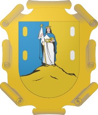
Both the name and the coat-of-arms of the state of San Luis Potosi recall the tremendous importance of mining to Mexico’s economy.

SLP-coat-of-armsCalled Potosí in emulation of the mines of that name high in the Bolivian Andes, the city’s coat-of-arms, awarded in 1656, has its patron saint standing atop a hill in which are three mine shafts. Left of the hill are two gold ingots, and right of it, two silver ones.

Some of the early mining towns in San Luis Potosí faded into obscurity, others became centers for ranching and commerce. The best known former mining town, Real de Catorce, for long considered a ghost town, has been resuscitated by tourism.

For visitors planning to see Real de Catorce, the best place to stay the night before is Matehuala, on highway 57, which has a full range of tourist services. From Matehuala, it is short distance west to Cedral. Shortly after Cedral a 24-kilometer-long cobblestone road climbs up the mountain to Real de Catorce, which sits at an elevation of  2,743 meters (9,000 ft) in the Sierra de Catorce range.

Real de Catorce

Main street of Real de Catorce. Credit: Tony

Main street of Real de Catorce. Credit: Tony Burton

The first surprise for visitors is the single file 2,300 meter long Ogarrio tunnel – the only entrance to the town from the north – a unique introduction to the many strange things awaiting you on the other side. The second surprise  is how such a large place, which produced more than 3 million dollars worth of silver each year, could ever have become a ghost town. Between 1788 and 1806, the La Purisima mine alone yielded annually more than $200,000 pesos of silver– and that was when a peso of silver was equivalent to a dollar.

The large, stone houses, often of several stories, with tiled roofs, wooden window frames and wrought-iron work, were so well built that they have survived to tell you their tales as you wander through the steep streets, soaking up the atmosphere of one of Mexico’s most curious places.

You need time to really appreciate the former grandeur of Real de Catorce. Fortunately, there are several simple hotels and restaurants. It is well worth hiring a local guide.  An enthusiastic guide will wear your feet out long before you tire of their informative commentaries.

Seek out the beautifully restored palenque (cock-fighting pit). Pause in the church to examine the mesquite floor, imaginatively described in some guidebooks as comprised of a mosaic of coffin lids. The church is dedicated to Saint Francis of Assisi. The two week long fiesta in his honor, centered on October 4th, is a huge affair, attended by hundreds of returning Real de Catorce families.

In front of the church, across the small plaza of Carbón, is the former mint. This gorgeous building is well worth visiting and now used for cultural events such as photographic exhibitions. Look in the gallery and perhaps you’ll find an irresistible, original, handcrafted item made of locally mined silver.

The town of Real de Catorce and its surroundings are sufficiently photogenic that several movies have been filmed here, including Bandidas (featuring Salma Hayek and Penélope Cruz) and The Mexican (featuring Brad Pitt and Julia Roberts).

The town, designated a Magic Town in 2001, has several small hotels and restaurants for those wanting to spend more time here.

This area has close associations with the indigenous Huichol (Wixarika) Indians who call this area Wirikuta. Each spring, they visit Cerro del Quemado, a hill within easy hiking distance of Real de Catorce, to leave religious offerings. The Huichol collect the hallucinogenic cactus peyote, used in some of their ceremonies, from the surrounding desert during an annual spiritual pilgrimage to Wirikuta from their heartland in northern Jalisco, 400 km (250) miles away. Cerro del Quemado was declared a National Sacred Site in 2011. An upcoming full length documentary about the Huichol Indians, the “Huicholes: The Last Peyote Guardians“, includes shots of the pilgrimage, while looking at how the continuation of the pilgrimages could be threatened by proposed mining projects.

Related posts:

Magic Town #66: Lagos de Moreno, “the Athens of Jalisco”

 Mexico's geography in the Press  Comments Off on Magic Town #66: Lagos de Moreno, “the Athens of Jalisco”
Nov 242012
 

Lagos de Moreno, just designated Mexico’s Magic Town #66, is a town with a charming ambiance. A succession of small squares with old trees and gardens, connected by shaded streets, gives it a cultured university air. At every turn there are beautifully kept old buildings to be enjoyed and it is absolutely fitting that the town, in its entirety, should have been declared a national monument.

Lagos de Moreno is Jalisco’s fifth Magic Town. Boasting more than 380 cultural and historic sites, its peak coincided with the governments of President Porfirio Díaz in the late 1800s when local haciendas produced both an aristocratic elite and plenty of money enabling them to enjoy what they considered were the better things in life.

La Rinconada restaurant, Lagos de Moreno

La Rinconada restaurant, Lagos de Moreno. Credit: Mark Eager / Sombrero Books

Lagos was founded as Santa María de los Lagos in 1563 on the west bank of the broad Lagos River. It assumed its modern name in 1827. In early colonial times, its inhabitants had to withstand repeated attacks from the Chichimecas. When silver was discovered in large quantities near Zacatecas, further north, the town became a natural staging-post on the mule route to Mexico City, where all colonial silver was taken for assaying. At the same time, the main contraband route across Mexico, between Tampico, on the Atlantic, and San Blas, on the Pacific, passed through the town. As a result of this strategic location, the city was fortified with walls, some of which still remain. There are few examples in Mexico of colonial walled cities. Lagos is one of the best preserved.

The width of the river necessitated the construction of a bridge, at least for more modern traffic, and in the eighteenth century Lagos Bridge was built on the northern edge of the town. This bridge is the subject of one of the charming tales in El Alcalde de Lagos (The Mayor of Lagos), a delightful collection of witty short stories compiled by Alfonso de Alba. The stories capture the provincial nature of the town perfectly, complete with the very different perceptions of the local intelligentsia and their rural campesino counterparts as the town grew to maturity.

The imposing ultrabaroque parish church of the Assumption is also eighteenth century and looks onto the principal plaza. Two blocks away, the former Capuchinas convent has been converted into the Casa de la Cultura, with a concert hall, spaces for art exhibits, library and music classes. Few Casas de la Cultura anywhere in the country are housed in quite such an historic or magnificent building. Walk into the patio and see for yourself. The mural inside depicts Pedro Moreno, hero of the Independence movement, who was born near the town, and after whom the town is named. Another building in the Capuchinas square houses the Agustín Rivera Museum with its displays of archaeological and historical items.

Behind the parish church is the Rosas Moreno theater, one of the few provincial theaters to have survived with its interior spaces and decorations unchanged from the end of the nineteenth century. This building, designed by Primitivo Serrano, was begun in 1887, and inaugurated in 1907. It is named in honor of locally-born José Rosas Moreno, the Children’s Poet, a renowned writer of fables. Serrano built many other fine buildings in Lagos de Moreno, and his influence is everywhere in the lovely Hacienda Las Cajas, now a small hotel.

The central area of Lagos de Moreno, with its romantic corners and shaded walks, is a place to wander through slowly, savoring the sights and sounds of an unashamedly provincial town, one proud of its history and still retaining a dignified air. An overnight stay allows visitors to savor the unique atmosphere of this lovely town in the early morning or late evening when lower-angled sunlight shows the colors and details in the stonework to best effect.

[Lightly edited extract from Tony Burton’s Western Mexico: A Traveler’s Treasury.]

Related posts:

The geography of Tequisquiapan, a spa town in the state of Querétaro

 Other  Comments Off on The geography of Tequisquiapan, a spa town in the state of Querétaro
Jun 142012
 

The town of Tequisquiapan is an excellent place for geographers!

For one thing, it has a monument claiming to be The geographic center of Mexico. While this is hotly disputed, it is a fun place to start!

Tequisquiapan is an attractive spa town which has many hotels, restaurants and stores. It has grown substantially in recent years, attracting former Mexico City dwellers tired of the traffic congestion, smog and challenges of living in the big city. Mid-week, Tequisquiapan is largely deserted, with the air of a ghost town, waiting for revival. Revival occurs every weekend as the wealthier residents of Mexico City flee the city in search of clean air and blue skies. The town’s restaurants begin to fill and the discos gear up for action lasting into the early hours. Many of the weekenders now own second homes in Tequisquiapan.

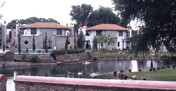
Upmarket homes in Tequisquiapan. Photo: Tony Burton; all rights reserved

Upmarket homes in Tequisquiapan

Why is Tequisquiapan such an attractive choice for them? The key attractions (see Tequisquiapan, Querétaro: a delightful spa town)  are:

  • a small town atmosphere, with winding cobblestone streets, lined by attractive and neatly kept one-story buildings
  • the town boasts a dozen or more “three star” or better hotels, all with thermal swimming pools, and a multitude of handicraft shops and galleries
  • an 18-hole golf course, open to the public
  • a specialist handicrafts market, a lively permanent market and, on weekends, numerous small street stalls selling precious stones and jewelry (for enticing pictures, see Tequisquiapan, provincial Mexican charm  on MexConnect.com)
  • the town is small enough to walk around and bathed in sunshine virtually all year round
  • an annual cheese and wine festival in early summer
  • it is less than two hours by car from Mexico City
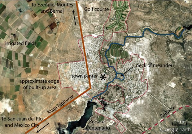
Annotated Google Earth image of Tequisquiapan area

Annotated Google Earth image of Tequisquiapan area

Anyone interested in urban geography will find that Tequisquiapan’s layout is quite unusual (for Mexico).  Some streets in the center of the town wander aimlessly rather than conforming to the traditional Mexican grid pattern. By way of comparison, a newer area of settlement across the highway (see image above) exhibits perfect grid pattern.

Bougainvillea-covered wall in Tequisquiapan

Behind the stone walls of the many fine hotels, the spa waters of Tequisquiapan offer their temptation. Why hike the streets when you can laze by a pool? The water is tepid rather than hot but very welcome, given the arid heat that envelops this area most of the year.

Towards the south-east, the town has grown around existing farmland, so homes surround an undeveloped core of agricultural land.

To the north, a former hacienda (Hacienda Grande) has been converted into a residential area built around a golf course. The irrigated fairways are strikingly visible on Google Earth.

Tequisquiapan is one of the few Mexican towns of its size and age to have a gated community in the downtown core, immediately off the main plaza.

Physical geographers won’t be disappointed either. Also near the center, upmarket houses have been built on the neck of a cut-off meander which has left an “island” with the river on either side. Floods on this river are now unlikely since it is controlled by the Centenario dam which has created a reservoir, Presa el Centenario, used for water sports.

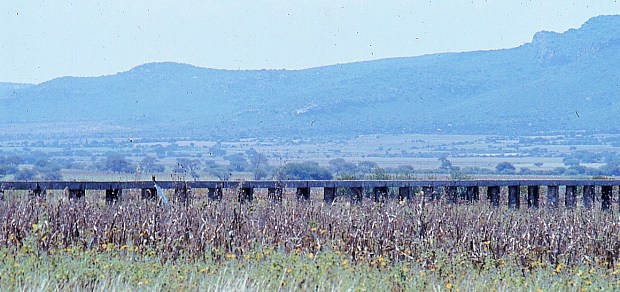
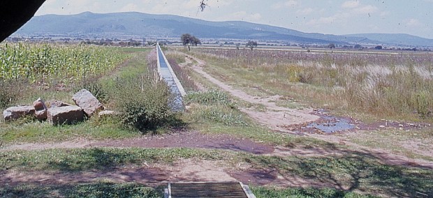
The flat valley floor around Tequisquiapan has become a rich farming area, particularly well known for its vineyards. A network of aqueducts and irrigation channels helps farmers overcome the vagaries of the annual dry season.


Aqueduct near Tequisquiapan. Photo: Tony Burton; all rights reserved.

Aqueduct near Tequisquiapan

The fact that this area has a pronounced dry season means that most local streams are intermittent; they run only for short periods during and immediately after the rainy season. The rest of the year, their channels are dry, providing a perfect opportunity for physical geographers to walk along them studying their features and landforms, without even getting their feet wet!

Irrigation channel near Tequisquiapan. Photo: Tony Burton; all rights reserved.

Irrigation channel near Tequisquiapan

On balance, given all these points of geographical interest, maybe Tequisquiapan is right to call itself the “geographic center” of Mexico after all!

Photos:

All photos in this post are by Tony Burton; all rights reserved.

Magic or mystery? Mexico adds four more Magic Towns to its list

 Mexico's geography in the Press  Comments Off on Magic or mystery? Mexico adds four more Magic Towns to its list
Jun 022012
 

Mexico’s Tourism Secretariat has designated four more Magic Towns, bringing the total number to fifty-four. The latest Magic Towns are:

51. Angangueo (Michoacán)

Angangueo is an attractive former silver-mining town. At the entrance to the town are strange, step-sided earth mounds; these are not pre-Columbian pyramids but twentieth century spoil-tips.

Angangueo’s pretty single-story buildings with red roofs and flower-filled porches line a narrow main street which gradually meanders up to the head of the valley and the town plaza. There are two large churches on this plaza, an obvious sign of the town’s former wealth. Worth visiting, one block uphill from the plaza, is the former residence of Bill Parker, 1930s mine superintendent, and his wife Joyce, a keen photographer. Mining in Angangueo declined after a serious accident in 1953, said to have been caused by the company’s foreign management in response to a threatened strike. The miners who lost their lives in this accident are commemorated by a huge statue which overlooks the town.

Angangueo. Sketch by Mark Eager; all rights reserved.

Angangueo, c 1980. Sketch by Mark Eager; all rights reserved.

The hustle and bustle of industrial activity has been replaced by a slower, more leisurely approach to life. In Angangueo, afternoon siestas are still the norm; don’t expect the small stores to reopen at any particular time in the afternoon. Railway enthusiasts will appreciate not only the standard-gauge mainline and its end-of-the-line station which squeezes the town’s main street against the valley side but also the narrow-gauge mining track which burrows deep into the hillsides.

From 1980-2010, Angangueo acquired a new lease of life as a tourist town, taking advantage of its location close to two major Monarch Butterfly sanctuaries. However, in February 2010, the town suffered extensive flood damage when landslides and mudflows swept away dozens of homes, killing at least 30 residents.

{The illustration and parts of the description are taken, with permission, from chapter 30 of Tony Burton’s “Western Mexico, a Traveller’s Treasury”)

52. Cuatro Ciénegas (Coahuila)

Cuatro Ciénegas (“Four marshes”) is a city and municipality in the northern border state of Coahuila. Situated in an arid region (part of the Chihuahuan desert), its name derives from the proximity of several natural springs that feed more than 200 small ponds and wetlands. These are an integral part of the UNESCO-designated Cuatro Ciénegas biosphere reserve. The city, founded in 1800, has some historical significance, since it was the birthplace of Venustiano Carranza, Mexico’s president from 1915 to 1920.

53. Magdalena de Kino (Sonora)

Magdalena de Kino is a city (and municipality) in an agricultural area in the northern state of Sonora, about 80 km (50 mi) from the Mexico-USA border. The earliest mission was established here by Father Eusebio Francisco Kino (“Padre Kino”), whose remains are now interred in a crypt near the mission. Father Kino was a tireless evangelist and educator, who led explorations of the virtually unknown areas that are, today, the states of Sinaloa, Sonora and Arizona, founding numerous missions as he went.

Magdalena de Kino has several stone buildings of historic or tourist interest, including the Padre Kino Museum and the Temple of Santa María Magdalena, a place of pilgrimage. The city’s main religious festival is held to coincide with 4 October each year.

54. Pahuatlán (Puebla)

Pahuatlán (“place of the fruits”) is a town and municipality in the state of Puebla. In early times, the town, in the mountainous northern region of the state, was a zone of conflict between several indigenous groups. The area has retained many traditions, including that of making paper by hand from tree bark. The Otomí village of San Pablito, in the Pahuatlán municipality, is by far the best-known center of production for this bark paper or amate. The word amate derives from amatl, the Nahuatl word for paper.

Besides being used as a kind of rough paper for records and correspondence, amate was also cut into human or animal forms as part of witchcraft rituals after which it would be buried in front of the person’s house or animal enclosure. Colorful paintings on papel amate or bark paper are sold throughout central Mexico, virtually anywhere there are tourists. The tradition is an ancient one.

In the village of San Pablito, villagers (mainly women and children because many of the menfolk have left to work in the USA) wash the bark, boil it with a solution of lime juice for several hours, and then lay it in strips on a wooden board. They then beat these pulpy strips with stones called muintos or aplanadores until they fuse together to form the desired texture of paper, which is then allowed to dry in the sun.

Centuries of practice enable them to produce amate paper of any thickness, from the equivalent of crepe-paper to poster-board. Visitors to San Pablito quickly discover that the constant sound of pounding is a distinctive reminder of the village’s main industry.

Related posts:


Jun 252011
 

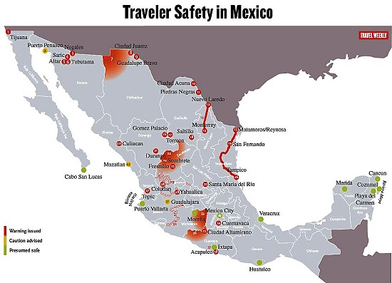
Over the past year, the US State Department has issued repeated warnings about travel in Mexico. Some of these warnings are specific to certain stretches of highway; others are broader and focus on cities or regions.

Travel Weekly has produced a handy map showing the areas currently affected by advisories (a version of this map appears below). Resorts colored green are “presumed to be safe”, while yellow means “caution” and red means “warning issued”.

  • Link to the Travel Weekly pdf map with full details, explaining the significance of each numbered location,
Traveler Safety in Mexico. Map Credit: Travel Weekly – www.travelweekly.com/mexicomap/

Note that “Sombrete” on the map, near Fresnillo, should actually be Sombrerete. (Curiously, this is the exactly same mistake made recently by the Victoria and Albert Museum in London in the text accompanying a display about silver in Latin America. Sombrerete was a very important silver-mining center during colonial times, and the town is well worth visiting, advisories permitting, for numerous fine colonial buildings).

Given the map, it is perhaps not really a great surprise that Mexico’s federal Tourism Department is currently actively promoting the Caribbean coast and “Mundo Maya” (Maya World), a region well removed from the red-colored zones on the map.

According to a slew of articles in Mexico’s Spanish-language press:

The first geography field trip guide in Mexico

 Books and resources, Teaching ideas  Comments Off on The first geography field trip guide in Mexico
Apr 032010
 

Despite the popularity of geography in Mexico’s high schools, students are rarely involved in any geographic fieldwork until they reach university. The major exceptions are those students lucky enough to attend one of the international schools offering courses such as the International Baccalaureate (IB) Diploma Programme. The IB geography syllabus requires all students to have undertaken and written up a report on fieldwork. Most IB fieldwork is hypothesis-based.

It is perhaps not surprising therefore that the number of publications relating to fieldwork in Mexico is very small. There have been a limited number of specialist “field guides” published, relating to geology and geography, and coinciding with international conferences.

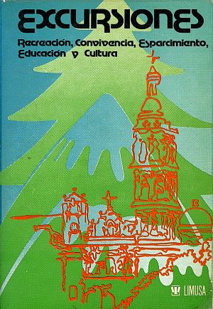
To the best of my knowledge, the first fieldwork guide aimed at high school students, teachers and the general public was written following a meeting of teachers in Mexico City in March 1979. Excursiones was designed to be a guide for “teachers, parents and/or organized groups interested in finding pleasant and educational ways of enjoying our environment and encouraging the spiritual elements inherent in making use of the tourist attractions that form part of Mexico’s heritage.”

The book, published by Editorial Limusa in 1983, has 14 general chapters (clothing, food, first aid, etc), followed by 17 destination specific chapters:

  • Cacahuamilpa
  • Taxco
  • Zempoala
  • Tepoztlán
  • Desierto de los Leones
  • Ruta de la Estrella
  • Valle de Bravo
  • Isla de los Aves-Ocotal
  • El Xinantécatl and its lakes
  • Piedras Encimadas
  • Ruta de los Volcanes
  • Africam Safari
  • El Chico
  • Basalt columns
  • Tolantongo
  • El Xitle and El Ajusco
  • Chapingo-Texcoco

We’ll take a closer look at the opportunities offered for fieldwork in some of these locations in future posts.

“La Curva de la Gringa”, the American woman’s curve, a place name in Michoacán, Mexico

 Maps, Mexico's geography in the Press, Other  Comments Off on “La Curva de la Gringa”, the American woman’s curve, a place name in Michoacán, Mexico
Mar 302010
 

Another interesting example of an unusual place name (following on from an earlier post about unusual place names) is the name “La Curva de la Gringa”, the American woman’s curve.

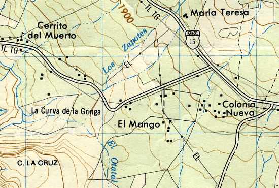
La Curva de la Gringa is the name of a 90-degree bend near Jungapeo, west of Zitácuaro in the state of Michoacán. Literally translated as “the American woman’s curve”, how did this name come about? The first thing to remember is that all names on maps have to come from somewhere. Detailed maps of Mexico, including the 1:50,000 series, relied initially on aerial (later satellite) imagery, followed by some checking on the ground. Given the expense, ground checking was often relatively limited. However, the on-the-ground surveyors were responsible for adding names to the maps.

La Curva de la Gringa, Michoacán (on Mexico’s 1:50,000 topographic map)

In this case, local informants were apparently unanimous in calling this bend La Curva de la Gringa. Further research shows that this had nothing to do with any purported similarity to the sensuous curve of a gringa‘s breast, but derived from when the road was first paved in the 1950s. Apparently, shortly after the road was finished, an American lady driving her oversized gas-guzzler down to the luxury spa of San José Purua completely missed this bend, and plowed into a cornfield. The locals have long memories!

In 2010, this road is being widened, and sidewalks and street lights installed, all the way from Federal Highway 15 (see map), past La Curva de la Gringa, and as far as the money allocated (currently about 7 million pesos) allows. The first section was due to be inaugurated 21 March 2010. If anyone has an update, please leave a comment. Here’s hoping that no more accidents ever occur along this stretch of road, and that no future place names ever reflect such unfortunate incidents.

Mar 242010
 

Update: New Durango-Mazatlán highway officially open (Oct 2013)

Update [October 2012]: Despite earlier claims that the Durango-Mazatlán highway would be completed before the end of 2012, government officials have now confirmed that the highway will not be finished, and will not open, until sometime in 2013.

Update [5 January 2012]:

Original post:

A truly amazing feat of engineering brilliance will force the authors of Geo-Mexico to revise one of their many original maps, when preparing the book’s next edition!

Figure 17.4 of Geo-Mexico is a map using isolines to show the average driving times by road from the city of Durango to everywhere else in Mexico. The map shows that it currently takes about five hours to drive the 312 km from Durango to the Pacific coast resort of Mazatlán, whereas driving south-east for five hours can take you as far as Encarnación de Díaz, 460 km away. The reason for this difference is that the rugged mountains of the Western Sierra Madre separate Durango from Mazatlán, whereas no significant relief obstacles lie between Durango and Encarnación de Díaz.

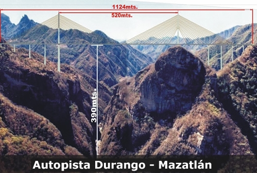
However, this pattern will change significantly once a new 1.2-billion-dollar highway between Durango and Mazatlán is complete. The four-lane, 230-kilometer-long highway is already well advanced; it will greatly reduce the travel time between the two cities. The major ‘missing piece’ remaining to be finished is the Puente Baluarte Bicentenario (Baluarte Bicentennial Bridge).

Puente Baluarte Bicentenario. Photo: TRADECO

This will be the biggest cable-stayed bridge ever built in Latin America. It is 1.124 km long and 4 lanes wide. Its central span extends 520 meters. At its highest point, it is a gravity-defying 390 metres (1280 feet) above the River Baluarte from which it takes its name. The bridge’s largest supporting pillar is 153 meters high, with a base measuring 18 meters by 30 meters.

Construction, by Mexican firm TRADECO, has required 103,000 tons of cement and almost 17,000 tons of steel. The bridge joins the states of Durango and Sinaloa and removes the need for drivers to negotiate a very dangerous stretch of highway known as the Devil’s Backbone.

Meanwhile, the authors of Geo-Mexico are busy preparing a map to show the next best example in Mexico where extreme differences of terrain influence travel times between major cities! Hopefully, the government won’t immediately use the new map in the next edition of Geo-Mexico to decide where to build their next major highway!

The development of railways led to tourist guide books

 Other  Comments Off on The development of railways led to tourist guide books
Mar 012010
 

In the golden age of steam, railway lines were built all over Mexico. Rail quickly became THE way to travel. Depending on your status and wealth, you could travel third class, second class or first class. Anyone desiring greater comfort and privacy could add their luxury carriage to a regular train. To avoid mixing with the ordinary folk, the super-rich and the privileged few hired or ran their own special trains.

The railway era ushered in an entire new genre of travel writing, which culminated in the first genuine guidebooks, describing routes and places that other travelers could visit with relative ease. The earliest comprehensive guide to Mexico was Appletons’ Guide to Mexico (1883); it was soon followed by several others including Campbell’s Complete guide and descriptive book of Mexico, first published in 1895.

The 1899 edition of Reau Campbell’s famous Guide provides an idea of what visitors to Cuautla in the state of Morelos, for example, could expect when the train was in its heyday:

Here again the tourist finds another feature of Mexico’s scenery and people, totally different from all the other travels in the Republic. The houses are adobe as to walls and thatched as to roofs; the broad plains have curious trees; bands of Indians troop from one town to another in curious costumes, marching along totally oblivious to the passing locomotive and approaching civilization, and will not give way to the latter any quicker than they will to the engine if they happen to be on the track when it comes along. In fact, it is hard for them to understand that the train cannot “keep to the right” when it meets people in the road, and they claim the right of way from the fact that they were there first.

A decade later, the British-born journalist William English Carson (1870-1940) spent four months in Mexico. Carson also visited Cuautla, on the advice of a doctor as the result of catching influenza.

Upon making inquiries at the railway office about trains to Cuautla, the clerk handed me an illustrated pamphlet with a fine colored picture on the cover representing a Mexican tropical scene. It bore the title, “Cuautla, Mexico’s Carlsbad.” What! I thought, another Carlsbad? In glowing language the booklet described Cuautla as an earthly paradise with a magnificent climate, beautiful scenery, splendidly equipped hotels and a warm sulphur spring whose waters were a certain specific for almost every human ailment. What more could one desire?

Carson continues:

Cuautla is about a hundred miles or so from Puebla, and the speedy trains of the Interoceanic Railway take about ten hours to make the journey. The train which I took left about seven o’clock in the morning ; it was not timed to reach Cuautla until five in the evening; and as there was not any restaurant at any intermediate station, a somewhat terrifying prospect of starvation faced travellers. How were they to get their luncheon? A little pamphlet given away by an American tourist agency and evidently written by an accomplished press-agent gave me the desired information: “At a certain station on the road,” said my traveller’s guide, “your train will stop for some twenty minutes. Here you will be greeted by graceful Indian women,— beauties, many of them, with their olive skins and dark, flashing eyes, bearing themselves with queenly grace in their dainty rebosos and flowing garments, white as the driven snow. They will offer you such dainties as tamales, chili-con-carne and tortillas, piping hot from their little stoves, and prepared with all the scrupulous cleanliness of a Parisian chef. They will bring you dainty refrescos of freshly gathered pineapple or orange to quench your thirst, and pastry such as your mother may have made when her cooking was at its prime.”
Now, what more could any reasonable traveller demand? What need was there for a restaurant when there were all these good things to be enjoyed? I showed my guide to an American friend before I started. He chuckled, gave a knowing wink and remarked, “Great is the faith of man, for after all your experiences you can still believe in a Mexican guide-book.”

Hotels were not always the same standard as those in the USA, but were certainly less expensive:

The attractions of the hotel were hardly up to those of a Carlsbad establishment, for it had neither a writing nor a smoking room; but the terms were rather more attractive than the usual Carlsbad tariff, being about two dollars a day inclusive. It is true there was a good deal of Mexican about the cooking, but the meals were not at all bad and the service very fair…

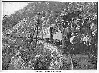
Railways may have opened up Mexico for tourism, but today, sadly, there are virtually no passenger lines still operating, the main exception being the justly famous Copper Canyon line from Los Mochis to Chihuahua.

Sources:
Campbell, Reau. Campbell’s New Revised Complete Guide and Descriptive Book of Mexico. Chicago. 1899.
Carson, William English. Mexico: the wonderland of the south. 1909

This is an edited version of an article originally published on MexConnect.
Click here for the complete article

The growth of the railway network and the importance of railways in Mexico are examined in depth in chapter 17, and tourism in Mexico is the subject of chapter 19. of  Geo-Mexico: the geography and dynamics of modern Mexico.

Feb 132010
 

Mexico’s mass tourism industry in the past forty years has been dominated by large-scale, purpose-built developments partially funded by federal funds. In 1967, responding to bullish predictions of US demand for beach vacations,  Mexico’s central bank identified the five best places for completely new, purpose-built tourist resorts. Top of the list, as part of a 30-year plan, was the uninhabited barrier island now known as Cancún. The other choice locations were Ixtapa, Los Cabos, Loreto and Huatulco.

The National Fund for Tourism Infrastructure (renamed the National Tourism Development Fund, Fonatur, in 1974) began building Cancún in 1970 and Ixtapa in 1971.

Cancún has become Mexico’s foremost tourist resort. Factors considered in the choice of Cancún included water temperatures, the quality of beaches, varied attractions, sunshine hours and travel distances from the main markets. The stated benefits were thousands of new jobs, increased revenues, the development of a previously peripheral region and the diversification of the national economy.

Public funds were used to purchase land, improve it by fumigation and drainage, and install all necessary basic infrastructure (airport, highways, potable water, electricity, telephone lines, convention center, golf course, harbors). Private sector investors developed hotels, a shopping center and supporting services.

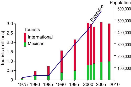
By 1975, Cancún had 1769 rooms in service; by 2008, it boasted about 150 hotels and more than 27,000 rooms. Second only to Mexico City, Cancún airport now handles 200 flights a day. The influx of people to Cancún has been especially dramatic. The city has had to cope with unprecedented growth rates as its population shot up from 30,000 in 1980 to 676,238 in 2010 (preliminary census figure) (see graph).

The number of tourists in Cancún dipped slightly in 2001–2002 due, in part, to the 2001 9/11 tragedy in the USA. Hurricane Wilma (2005) put many hotel rooms temporarily out of commission. Cancún is now only one focus of an extensive tourist corridor along the Quintana Roo coast, stretching as far south as Tulum.

Chapter 19 of Geo-Mexico: the geography and dynamics of modern Mexico, from which this extract is taken, looks in much more detail at Mexico’s purpose-built resorts as well as many other  aspects of tourism, resorts and hotels  in Mexico.