President Zedillo’s political reforms brought real democracy in Mexico

 Other  Comments Off on President Zedillo’s political reforms brought real democracy in Mexico
Oct 272010
 

A previous post focused on the economic reforms of President Ernesto Zedillo, 1994-2000. This article discusses his very important political reforms.

1994 was a very important and difficult year for Mexico. It started with the Zapatista rebellion in Chiapas, which the PRI (Partido Revolucionario Insititucional) government brutally put down, infuriating many Mexicans and leading to giant protest demonstrations against the PRI. Liberation theology was gaining strength and blaming PRI for human rights abuses as well as the impoverishment of the Mexican people. Furthermore, the economy was slipping into a severe crisis.

Following tradition, President Salinas personally selected Donaldo Colosio to succeed him as the PRI President of Mexico. While other parties nominated candidates, PRI had held an iron grip on the Presidency and Mexican politics for over 60 years.

In March 1994 the PRI presidential candidate Colosio was assassinated in Tijuana. The PRI was held responsible for all the country’s problems and Salinas was in a very difficult spot. Old PRI hard-liners (“dinosaurs”) pressed Salinas to name one of them as the next president, but Salinas knew he had to select a “clean” candidate that would help the PRI regain some credibility. Salinas selected as the replacement, Colosio’s young campaign manager and technocrat Ernesto Zedillo. Zedillo, the “accidental president”, easily won the relatively fair 1994 election.

Zedillo was dedicated to political reform. He took dramatic steps to counter corruption. Apparently not trusting anyone within his own PRI party, he appointed as his Attorney General, Antonio Lozano Gracia from the opposition PAN party. Lozano aggressively prosecuted and indicted numerous senior PRI officials, including Salinas’ brother, on a variety of corruption charges. In 1995 Zedillo replaced the country’s entire Supreme Court, which then began to rule against PRI dominated government agencies on a regular basis. Zedillo implemented reforms which separated the ruling PRI party from the Government of Mexico, thus terminating the practice of using government agencies and revenues to support PRI political campaigns.

Zedillo initiated multiparty talks on political reform and began transferring some power away from his own office and toward Mexico’s Congress and 31 states. He made the Federal Elections Commission more transparent by increasing the oversight and participation by opposition parties. He reformed the law giving the President the power to appoint the Mayor of Mexico City, who henceforth would be popularly elected.

These reforms brought dramatic change to local, state, and national elections in July 1997. The opposition PDR party candidate for Mexico City mayor, Cuauhtémoc Cárdenas, garnered nearly 50% of the vote and was elected, defeating the PRI candidate by a wide margin. Opposition party candidates also swept several state governorships. Most significantly, the PRI lost control of the lower house of the Mexican Congress for the first time in history. Finally, after almost 70 years of PRI domination, Mexico was becoming a real democracy and the Mexican public rejoiced in their new democratic powers.

Zedillo decided not to personally select his successor in the traditional way. Instead, the PRI would hold a national primary enabling the voters to select the next PRI presidential candidate. He also loosened the PRI government’s grip on the media, opening the door to more objective political reporting. Under Zedillo’s watch, Mexico enjoyed a clean and fair election in the summer of 2000 which, for the first time in over 70 years, elected a non-PRI candidate as President in the person of Vicente Fox of PAN.

The reforms of the Zedillo Administration largely leap-frogged Mexico from an economically-unstable, single party state, to a relatively modern 21st century multiparty democracy. President Ernesto Zedillo is distinguished from his predecessors by his integrity, vision, and for doing what was best for Mexico, not for himself, his cronies, or his political party. Ernesto Zedillo was and is an inspiration to his country and the world. Everyone living in Mexico owes him a great debt of gratitude for modernizing Mexico’s economy and democracy as well as making Mexico a far better place.

Chapter 12 of Geo-Mexico: the geography and dynamics of modern Mexico discusses the political map of Mexico. Buy your copy today to have a handy reference guide to all major aspects of Mexico’s geography!

President Zedillo’s reforms stabilized the Mexican economy

 Other  Comments Off on President Zedillo’s reforms stabilized the Mexican economy
Oct 202010
 

President Ernesto Zedillo (in office from 1994 to 2000) took unprecedented steps that set the stage for Mexico’s 21st century economy. Before discussing Zedillo’s economic reforms, it is useful to review the recent history of Mexico’s economy.

Following the fifty year “Mexican Miracle” of unprecedented economic growth and low inflation, the economy entered some very tough times in the early 1980s. Assuming high oil prices would continue, Mexico borrowed very heavily and could not pay its debts when oil prices plunged in 1981-82 and interest rates rose dramatically. The government suspended debt payments, devalued the peso by 500%, and nationalized the banks. The “lost decade” of the 1980s was an economic disaster, with inflation rates over 100% and economic growth hovering around 1%.

Economic growth improved a bit the early 1990s but President Salinas was forced to introduce strict price controls in an attempt to curb inflation. With a fixed exchange rate, the peso soon became severely overvalued. Then in January 1994, Zapatistas in Chiapas rebelled against the national government. Two month later, PRI Presidential candidate Donaldo Colosio was assassinated in Tijuana. Salinas selected as his replacement, Colosio’s campaign manager and technocrat Ernesto Zedillo, a Yale PhD Economist who had previously been a university professor, Minister of Planning and Budget as well as Minister of Education. Zedillo easily won the relatively fair 1994 election and was called the “accidental president” because he never sought the presidency and never previously held elected office.

Upon assuming office, Zedillo faced an impending severe economic crisis. As was customary, Salinas in his last year had spent very lavishly, severely aggravating the government deficit. The economic crisis of 1995 was characterized by a deep recession, hyperinflation, widespread bankruptcies, serious unemployment and soaring interest rates. He floated the peso which quickly moved from 4.0 to 7.2 to the US dollar.

President Clinton orchestrated a controversial $48 billion bail-out loan which eased the crisis. Conditions of the loan required very stiff and unpopular austerity measures including a 50% income tax hike, reduced public spending, privatizing some state-owned enterprises, and making the Central Bank of Mexico more independent from politics. Zedillo effectively implemented these reforms, knowing they were the best for Mexico’s future though they seriously hurt his public popularity.

The bailout reforms succeeded, the economy stabilized and began to grow, averaging over 5% between 1996 and 2000. Mexico repaid the bailout loan three years before its due date. During the crisis and throughout his term, Zedillo supported and expanded Mexico’s free trade (globalization) agenda.

The Mexican economy is now far more stable than is was in the years prior to the Zedillo reforms. Mexico appears to be completely beyond the self-inflicted economic crises it experienced in the late 20th century. The 2008-09 recession was serious but was completely beyond the control of Mexico. The Mexican economy appears to be recovering nicely in 2010.

Chapters 14 through 20 of Geo-Mexico: the geography and dynamics of modern Mexico discuss the components and characteristics of Mexico’s economy. Buy your copy today to have a handy reference guide to all major aspects of Mexico’s geography!
Happy 200th birthday, Mexico!

 Other  Comments Off on Happy 200th birthday, Mexico!
Sep 162010
 

Mexico is celebrating its bicentennial.

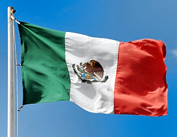
Mexican flag

The long struggle for independence began on this day in 1810; independence was finally “awarded” by Spain in 1821. By happy coincidence, 2010 also marks the centenary of the start of the Mexican Revolution. This has a less clear-cut ending date, with some Mexicans saying that it is still on-going today. It was during the Mexican Revolution that Mexico’s current constitution of 1917 came into effect.

For some geographic trivia associated with the War of Independence:

Events in the War of Independence called for an accurate map of Lake Chapala, Mexico’s largest natural lake. The cartographer for this map was José María Narváez, whose major contributions to Mexican cartography in succeeding decades have largely been forgotten.

Following independence, the rush was on to draw an accurate map of all of Mexico’s territory. Mexico’s boundaries following independence were very different to today. Flows of migrants linking the USA to Mexico at that time were from the USA to Mexico (see link),  the reverse of the direction of more recent flows, which have seen millions of Mexicans migrate north looking for work.

Political events conspired to bring Mexico into direct conflict with the USA in the Mexican-American War of 1846-1848. The 1848 Treaty of Guadalupe Hidalgo, signed after the war, ceded over half of Mexico’s territory to the USA. A few years later, under the 1853 Gadsden Purchase (Treaty of La Mesilla), northern portions of Sonora and Chihuahua were transferred to the USA. This established the current border between the two countries.

Minor modifications have been negotiated since to take account of changes in the meanders of the Río Bravo (Grande).

The first truly national map, compiled in 1857-1858 from a meticulous reconciling of the work of numerous local cartographers, was  drawn by Antonio García Cubas. García Cubas did not graduate from university until a few years after completing this map!

In the latter half of the 19th century, the development of Mexico’s railway network brought immense changes to many parts of the country. See, for instance:

In 1910, then president Porfirio Díaz decided that the centenary of Mexican independence should be celebrated in style. One of the reasons why the “traditional” Grito (“shout) is made on 15 September each year, rather than on the morning of 16 September (when Father Miguel Hidalgo apparently gathered his parishioners in revolt) is because 15 September 1910 happened to be Díaz’s 80th birthday. Why not have one big bash and celebrate both president and country at the same time? Unfortunately for the then president, the Mexican Revolution broke out later in the year and in 1911 Díaz was exiled to Paris.

One of the major events during the centenary of independence celebrations in 1910 was the opening to the public of Teotihuacan, the  archaeological site an hour’s drive north of Mexico City. Months of frantic cleaning and restoration were completed just in time for the official opening. This marked the start of mass tourism based on Mexico’s cultural heritage. The haste with which Teotihuacan was readied for tourists led to some unfortunate errors of reconstruction. For instance, the number of levels now seen on the Pyramid of the Sun does not correspond to its original form. Of course, Mexico’s unbridled pursuit of tourism in the past 80 or so years has led to lots of other serious environmental and cultural issues elsewhere.

Mexico has come a long way in 200 years, but amazingly, to the best of our knowledge, Geo-Mexico: the geography and dynamics of modern Mexico, published earlier this bicentennial year, is the first ever book in English focused exclusively on the nation’s  varied and fascinating geography.

¡Viva Mexico!

Mexican flag

Sep 032010
 

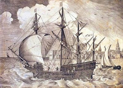
The “China galleons” greatly stimulated spatial interactions between Acapulco and Manila, 15,000 km away. Many Mexicans settled in Manila and scores of Nahuatl words entered Tagalog, the main Filipino language. These included atole, avocado, balsa, cacao, calabaza, camote, chico, chocolate, coyote, nana(y), tata(y), tocayo and zapote.

The Nao de China galleon

The China Galleon

As well as vocabulary, some aspects of Mexican cuisine, customs and dress were also introduced to the Philippines, along with a variety of plants and flowers. In addition, the Filipino currency has the same name as Mexico’s: the peso.

Mexico’s long connection with the Philippines – exploration, seafaring and geopolitics

A large number of Filipinos migrated in the other direction, escaping from their life of servitude aboard a galleon by jumping ashore on the coasts of Colima and Guerrero. One sizable Filipino community settled in Coyuca, on the Costa Grande, 50 km north of Acapulco. Coyuca was apparently known as Filipino Town at one point in its early history.

The Filipinos settling in Mexico introduced mangoes and a game called “cara y cruz” (heads and tails). The settlers were known locally as “Chinese Indians” and brought their expertise in the cultivation and use of palm trees with them. In Tagalog, palm fronds are known as “palapa” and by the end of the 18th century, this name was in use, too, for the palm-roofed shelters which remain a distinctive style of architecture along Mexico’s coasts.The coconut palm’s sap is known locally as tuba. Filipino newcomers fermented the resulting coconut wine into a potent drink. Henry Bruman, a University of California geographer, documented how Filipino seamen on the Manila Galleon also introduced simple stills, for making coconut brandy, to western Mexico during the late 16th century. These techniques were quickly adopted by Mexicans who were then able to turn the hearts of their native agave plants into tequila.

This is an excellent example of how developments in transportation can encourage cultural exchanges, and diminish the social, economic and cultural distance between places.

According to some historians, Mexico’s “China Poblana,” the woman who supposedly arrived from the East as a slave during the early 1600s and subsequently captured the hearts and minds of the people of Puebla, was actually a Filipino noblewoman who had arrived in Mexico aboard one of the Spanish galleons.

Mexico’s independence from Spain (1821) brought an end to the Manila–Acapulco galleons, though the network of shipping links then expanded from Veracruz to New Orleans and New York.

Mexico-Phillipines friendship has continued down the years.

For instance, in the second world war, several Mexican air force pilots, in the elite Escuadrón 201, were sent by the US government to lend their support in the Philippines. The pilots were decorated by the Philippine’s government for their heroism.

Related post

The development of Mexico’s transportation system is discussed in chapter 17 of Geo-Mexico: the geography and dynamics of modern Mexico. Its cultural geography is the subject of chapters 10, 11 and 13. Ask your library to buy a copy of this handy reference guide to all aspects of Mexico’s geography today! Better yet, order your own copy…

Sep 012010
 

Several famous writers wrote about Mexico despite having no direct geographic experience of the country. In an earlier post, we looked at the case of Jules Verne. This time, we look at Henry Wadsworth Longfellow.

There is some sound historical geography in the famous poem The Bells of San Blas, yet author Henry Wadsworth Longfellow had never ever visited the town.

The San Blas referred to in the poem is on the Pacific coast, in the state of Nayarit. It is a small town with several good hotels and restaurants, and a birding “hot spot”. The variety of habitats around the town, ranging from sandy beaches and luxuriant mangroves to palm plantations and tropical swamps, have attracted more than 500 different bird species, or about half of all the bird species known in Mexico.

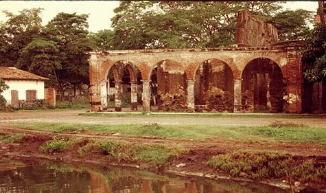
The town’s economy was not always geared to tourism. For more than a century, San Blas, founded in 1768, functioned as an important port and boat-building center. The vessels built in San Blas included those used by Junípero Serra to establish missions in California. To ensure that taxes were paid on imports, an imposing customs house was built on the shore. To guarantee safe passage, a church dedicated to “Our Lady of the Sailor’s Rosary” stands atop the steep-sided Cerro de San Basilio which overlooks the town. In the church hung the famous bronze bells.

San Blas Customs House

The former Customs House of San Blas in the evening light, 1989. Photo: Tony Burton. All rights reserved.

Time conspired against the port of San Blas. The harbor silted up, the coastline gradually inched its way further west. Over the years, other ports such as Acapulco and Mazatlan became more important. San Blas declined. The customs house and church were abandoned, transformed from bustling buildings into evocative ruins. By the end of the 19th century, the port was very much a “has been”.

In March, 1882, far away from Mexico, in Cambridge, Massachusetts, the American poet Henry Wadsworth Longfellow (best known for Paul Revere’s Ride, The Song of Hiawatha, and Evangeline) lay on his deathbed. Longfellow, born in 1807, was a prolific poet and accomplished linguist. After a long and illustrious career, which included teaching at Harvard College, his life was now drawing to a close, even as the distant port of San Blas was falling into disuse.

By a happy coincidence, the March 1882 issue of Harper’s new monthly magazine (Volume 64, Issue 382) contained an article by William Henry Bishop, entitled “Typical Journeys and Country Life in Mexico”. Bishop’s article described several Pacific coast ports, including San Blas:

“Acapulco has the most complete and charming harbor, and an old fort dismantled by the French, of the order of Morro Castle. Manzanillo is a small strip of a place on the beach, built of wood, with quite an American look. The volcano of Colima appears inland, with a light cloud of smoke above it. San Blas, larger, but still hardly more than an extensive thatched village, has, on a bluff beside it, the ruins of a once more substantial San Blas. Old bronze bells brought down from it have been mounted in rude frames a few feet high to serve the purpose of the present poor church, which is without a belfry, and this is called in irony ‘the Tower of San Blas.'”

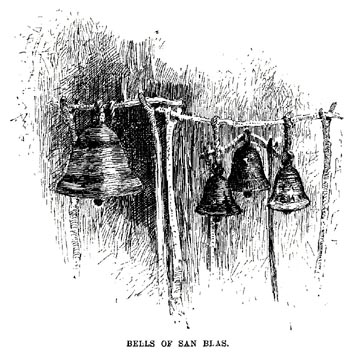
The article was accompanied by an illustration showing four bells swinging from a rickety wooden frame.

The Bells of San Blas, the illustration that sparked Longfellow's poetic imagination.

The article and its accompanying illustration prompted Longfellow to write what would prove to be his last poem, entitled The Bells of San Blas.

Like the port at that time, Longfellow saw the bells as relics from a byegone age:

They are a voice of the Past,
Of an age that is fading fast,
Of a power austere and grand;
When the flag of Spain unfurled
Its folds o’er this western world,
And the Priest was lord of the land.

The chapel that once looked down
On the little seaport town
Has crumbled into the dust;
And on oaken beams below
The bells swing to and fro,
And are green with mould and rust.

Several days later, Longfellow penned the last stanza, with a suggestion of optimism for the future:

O Bells of San Blas, in vain
Ye call back the Past again!
The Past is deaf to your prayer;
Out of the shadows of night
The world rolls into light;
It is daybreak everywhere.

On March 24, Longfellow, who had never had the good fortune to visit San Blas in person, passed away.

Should you visit San Blas today, spare a thought for this genius of a poet who was able to capture so eloquently the declining fortunes of this once-great port.

What further stanzas remain to be written in the story of San Blas, now revived by its important naval base and ornithological tourism?

Original article on MexConnect.

The development of Mexico’s transportation system is discussed in chapter 17 of Geo-Mexico: the geography and dynamics of modern Mexico. Ask your library to buy a copy of this handy reference guide to all aspects of Mexico’s geography today! Better yet, order your own copy…

Mexico’s long connection with the Philippines – exploration, seafaring and geopolitics

 Other  Comments Off on Mexico’s long connection with the Philippines – exploration, seafaring and geopolitics
Aug 232010
 

In 1559, King Philip II of Spain ordered a fleet to be prepared to sail west from New Spain (Mexico) to the Philippines. Barra de Navidad, on the shores of Jalisco, was one of the centers of New Spain’s maritime activity at the time. It offered a sandy beach in a well-protected bay; with tall forests inland to provide the necessary timber. Barra de Navidad echoed to the sounds of hammering and sawing, as the Spanish fleet was readied.

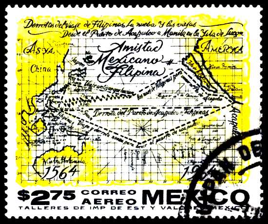
Mexican postage stamp commemorates 400 years of Mexico-Philippines friendship

Mexican postage stamp commemorating 400 years of Mexico-Philippines friendship

All western Mexico was mobilized to support the venture. Roads were built to ferry supplies from the city of Guadalajara to the Barra de Navidad boatyards. To this day, the main Guadalajara-Barra de Navidad road is known as The Philippines Way. Food, planks, sails and rigging – all had to be acquired and transported to the port. Every village had to support the effort, which was not without its dangers. For example, the Indians from Ameca complained of “many killed in the transport of rigging to Puerto de la Navidad where they are building boats to go to China.”

The expedition finally set sail at 3:00am on 21 November 1564, marking the start of more than 400 years of friendly contact between Mexico and the Philippines.

The expedition’s commander, López de Legazpi, fearing a mutiny, did not reveal their true destination to his sailors until the boats were well under way; no previous expedition had ever managed to find its way back across the Pacific Ocean. The expedition landed in the Philippines in March 1565. López de Legazpi remained there, putting his 17-year-old grandson in charge of finding the way back. In one of the most amazing feats of sailing of all time, his grandson was successful, but when the expedition reached Acapulco in October the crew was too exhausted to drop anchor. The return voyage had cost more than 350,000 gold pesos, and is commemorated today by a simple monument in Barra de Navidad’s small plaza.

The map on the stamp issued in 1964 to celebrate 400 years of friendship between Mexico and Philippines shows the expedition’s routes across the Pacific. The southern line marks the outward route, the northern line the route home.

The Spanish authorities quickly decided that bringing Asian goods from their colony in the Philippines back to Spain by crossing the Pacific, transshipping the cargo across Mexico and then sailing from Veracruz to Spain was preferable (more secure) to any alternative. Barra de Navidad soon became a regular port-of-call for Spanish sailors plying the so-called China route between Acapulco and Manila. To enable easier communication between Mexico City and Acapulco, a Camino Real (Royal Road) for pack mules was built between Mexico City and Acapulco. (A road suitable for wheeled vehicles between these cities was not completed until well into the 20th century.)

Demonstrating strong complementarity, for 250 years Spanish galleons carried Mexican silver to Manila and returned with spices, silk, porcelain, lacquer ware and other exotic goods from the Orient. These “China galleons” displaced 2000 tons and were the largest seafaring vessels of their time in the world.

But the lure of easy treasure drew pirates such as Englishman Francis Drake. In 1579, Drake sacked the small port of Huatulco, now a premier multi-million dollar tourist resort in the state of Oaxaca, and attacked the Manila galleon off the coast of California, exposing the vulnerability of Spanish sea traffic. For the next forty years, all the west coast ports, including Barra de Navidad, saw more pirates and corsairs than was good for them. Then, slowly but surely, the center of colonial operations moved further north into Sinaloa and Baja California.

Related Post

The development and characteristics of Mexico’s transportation network are analyzed in chapter 17 of Geo-Mexico: the geography and dynamics of modern Mexico. Buy your copy of this invaluable reference guide today!

El Camino Real or Royal Road, the spine of the colonial road system in New Spain (Mexico)

 Excerpts from Geo-Mexico  Comments Off on El Camino Real or Royal Road, the spine of the colonial road system in New Spain (Mexico)
Aug 042010
 

By the start of the 16th century, the Aztec Empire had a well developed system of “roads”.  However the Aztecs had neither wheels nor beasts of burden to transport themselves or their goods.  Obviously this limited transportation to the speed, range and endurance of foot power.  Their system of roads was essentially a system of foot trails.

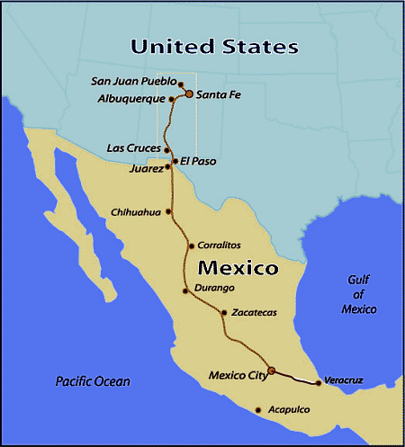
Map of Camino RealThe Spanish conquistadors found the Aztec roads completely unsuitable for horse traffic and animal-drawn carts. They were forced to undertake expensive re-routing, flattening, widening, and upgrading.  In 1550, they started construction of the first section of El Camino Real (the royal highway) linking Mexico City with Spain through the port of Veracruz.  The opening of this new road greatly facilitated communication and the transfer of Aztec gold to Spain, and Spanish goods to Mexico’s interior. To counter the threat of bandits, the road was constantly patrolled by soldiers.

Towns along this route gained new importance. Puebla become the second largest and most important city in New Spain, a position it was to hold for 300 years. In the late 1550s, the road was extended north to Zacatecas, to facilitate transporting gold and silver from that area back to Mexico City and then on to Spain.

El Camino Real was later extended to other important cities and mining districts.  By 1600 it reached as far north as Chihuahua and was later extended to Santa Fe (in what is now New Mexico).  Many other roads were added to the system to facilitate administration, communication and economic exploitation.

In 1565, the Spanish decided it was safer to ship Asian goods from their colony in the Philippines back to Spain by crossing the Pacific, transshipping the cargo across the breadth of Mexico, and then sailing from Veracruz to Spain. To support this, the El Camino Real was expanded to link Mexico City to Acapulco. This section was only serviceable for pack mules; a road suitable for wheeled vehicles was not completed until well into the 20th century.

For 250 years, Spanish galleons carried Mexican silver to Manila, and returned with spices, silk, porcelain, lacquer ware, and other exotic oriental goods destined for Spain.

The development of Mexico’s transportation system is discussed in chapter 17 of Geo-Mexico: the geography and dynamics of modern Mexico. Ask your library to buy a copy of this handy reference guide to all aspects of Mexico’s geography today! Better yet, order your own copy…

The connection between a Veracruz sugar plantation, San Francisco earthquake, Mexico tourist guide, and Mutiny on the Bounty

 Other  Comments Off on The connection between a Veracruz sugar plantation, San Francisco earthquake, Mexico tourist guide, and Mutiny on the Bounty
Jul 172010
 

At first sight, it would seem unlikely that a Veracruz sugar plantation could be linked, even indirectly, to Mutiny on the Bounty. The connection, which also takes in the San Francisco earthquake and one of Mexico’s most famous tourist guide books, is made via Charles Bernard Nordhoff, born in London, England in 1887, to well-to-do American parents.

When Charles was very young, the family moved to Berlin, where his mother wrote in the family diary that, “Charlie undoubtedly began his study of water fowl, as his daily outing in a small pram or push cart led him first to the bakeries for a supply of stale buns and back to the lake to feed the ducks.” The family also lived on a ranch near Todos Santos in Baja California, where as a young child, Nordhoff learnt to hunt, sail and fish.

Later, the family moved to California. Following in the footsteps of his grandfather, a journalist and  author, Charles Nordhoff wrote his first article at age 15 for an ornithological journal. He studied briefly at Stanford University, but left in the aftermath of the serious earthquake and fire of 1906.

After completing a B.A. at Harvard University, he moved back to Mexico in 1909 to work as a supervisor on a sugar plantation in Veracruz, where he was besotted with the owner’s attractive daughter. Unable to win the heart of the beautiful young lady, and with the Mexican Revolution breaking out around him, Nordhoff left Mexico in 1911; he never  returned.

But Nordoff’s adventures were far from over, In 1917, he joined the French Foreign Legion as a pilot, eventually winning the Croix de Guerre for his efforts. After the war, he wrote a history of the Lafayette Flying Corps. with James Norman Hall. Hall later landed the job of updating Terry’s Guide to Mexico, by far the most famous guidebook to Mexico of its era.

Nordhoff and Hall later moved to Tahiti to write travel articles for Harper’s, where Nordhoff married a Polynesian woman, Pepe Teara; they had six children. While Nordhoff wrote several books of his own, including several novels, he is best known for his collaboration with Hall on the Mutiny on the Bounty trilogy about the famous 1789 mutiny in the South Seas. The novel was the basis for three movie versions, the first of which, released in 1935, won an Oscar for Best Picture.

Tragically, following a severe depression and heavy drinking, Nordhoff took his own life on 10 April 1947.

This is an edited excerpt of a biography that first appeared in Tony Burton’s Lake Chapala Through the Ages, an anthology of travellers’ tales (Sombrero Books, 2008). All rights reserved.

The introduction of sheep caused widespread environmental damage in Mexico

 Books and resources, Excerpts from Geo-Mexico  Comments Off on The introduction of sheep caused widespread environmental damage in Mexico
Jul 032010
 

After the conquest, Spanish settlers introduced numerous Old World species into the New World. The most pernicious introductions were human-borne diseases, which led to the rapid and tragic decimation of the indigenous population. However, most of the introductions were deliberate, made with the intention of increasing the diversity of available food and resources. Among the non-native (exotic) plants and animals introduced were sheep, pigs, chickens, goats, cattle, wheat, barley, figs, grapevines, olives, peaches, quinces, pomegranates, cabbages, lettuces and radishes, as well as many flowers.

The environmental impact of all these introductions was enormous. The introduction of sheep to Mexico is a case in point.

In the Old World, wool had been a major item of trade in Spain for several centuries before the New World was settled. The first conquistadors were quick to recognize the potential that the new territories held for large-scale sheep farming.

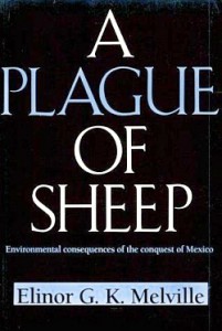
Cover of A Plague of SheepThe development of sheep farming and its consequences in one area of central Mexico (the Valle de Mezquital in Hidalgo) was analyzed  by Elinor Melville in A Plague of Sheep. Environmental Consequences of the Conquest of Mexico.

Melville divides the development of sheep farming in the Valle of Mezquital into several distinct phases. Sheep farming took off during Phase I (Expansion; 1530-1565). During this phase, the growth in numbers of sheep in the region was so rapid that it caused the enlightened Viceroy, Luis de Velasco, to became concerned that sheep might threaten Indian land rights and food production. Among the regulations introduced to control sheep farming was a ban on grazing animals within close proximity of any Indian village. At first the Indians did not own any grazing animals, and consequently did not fence their fields, which inadvertently encouraged the Spaniards to treat the landscape as common land.

During Phase II (Consolidation of Pastoralism; 1565-1580), the area used for sheep grazing remained fairly stable, but the numbers of sheep (and therefore grazing density) continued to increase. By the mid-1570s, sheep dominated the regional landscape and the Indians also had flocks. One of the consequences of this was environmental deterioration to the point where by the late 1570s, some farmers did not have adequate year-round access to pastures and introduced the practice of seasonal grazing in which they moved their flocks (often numbering tens of thousands of sheep) from their home farm in central Mexico to seasonal pastures near Lake Chapala.

This practice of grazing on harvested fields or temporary pastures was known as agostadero. This term originally applied to summer (agosto=August) grazing in Spain but was adopted in New Spain for “dry season” grazing, between December and March. So important was this annual movement of sheep that provision was made in 1574 for the opening of special sheep lanes or cañadas along the route, notwithstanding the considerable environmental damage done by the large migrating flocks. As flock sizes peaked, more than 200,000 sheep made the annual migration by 1579.

In the words of historian Francois Chevalier:

By 1579, and doubtless before, more than 200,000 sheep from the Querétaro region covered every September the 300 or 400 kilometers to the green meadows of Lake Chapala and the western part of Michoacán; the following May, they would return to their estancias.

The prime dry season pastures were those bordering the flat, marshy swampland at the eastern end of Lake Chapala. The Jiquilpan district alone supported more than 80,000 sheep each year, as the Geographic Account of Xiquilpan and District (1579) makes clear:

More than eighty thousand sheep come from other parts to pasture seasonally on the edge of this village each year; it is very good land for them and they put on weight very well, since there are some saltpeter deposits around the marsh.

By the end of Phase III (The Final Takeover; 1580-1600), most land had been incorporated into the Spanish land tenure system, the Indian population had declined (mainly due to disease) and the sheep population had also dropped dramatically. Contemporary Spanish accounts reveal that this collapse was attributed to a combination of the killing of too many animals for just their hides by Spaniards, an excessive consumption by Indians of lamb and mutton, and by the depletion of sheep flocks by thieves and wild dogs. Melville’s research, however, suggests that the main reason for the decline was actually environmental degradation, brought on by the excessive numbers of sheep at an earlier time.

The entire process is, in Melville’s view, an excellent example of an “ungulate irruption, compounded by human activity.” The introduction of sheep had placed great pressure on the land. Their numbers had risen rapidly, but then crashed as the carrying capacity of the land was exceeded. The carrying capacity had been reduced as (over)grazing permanently changed the local environmental conditions.

By the 1620s, the serious collapse in sheep numbers in the Valle de Mezquital was over; sheep farming never fully recovered. The landscape had been changed for ever.

Sources / Further reading:

  • Acuña, R. (ed) Relaciones geográficas del siglo XVI: Michoacán. Edición de René Acuña. Volume 9 of Relaciones geográficas del siglo XVI. Mexico City: Universidad Nacional Autónoma de México. 1987
  • Chevalier, F. Land and Society in Colonial Mexico. University of California Press. 1963.
  • Melville, Elinor G. K. A plague of Sheep. Environmental consequences of the conquest of Mexico. Cambridge University Press. 1994.

Click here for the original article on MexConnect.

Mexico’s ecosystems and biodiversity are discussed in chapter 5 of Geo-Mexico: the geography and dynamics of modern Mexico. The concept of carrying capacity is analyzed in chapter 19. Buy your copy today, as a useful reference book!

The story of Paricutín volcano in Michoacán

 Other  Comments Off on The story of Paricutín volcano in Michoacán
Jun 252010
 

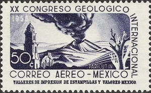
Paricutín first erupted, completely unexpectedly, in the middle of a farmer’s field, on February 20, 1943.

Paricutin depicted on postage stamp

Paricutín Volcano depicted on stamp

A remarkable account of its early days is given by Simón Lázaro Jiménez, who recounts in his book, Paricutín: 50 Years After Its Birth , his adventures as a young boy as he fled with his parents for safety as their small village of Angahuan was bombarded with red-hot rocks and ash. Don Simón’s account, which I was delighted to translate into English, may possibly be exaggerated in places, but remains the only first-hand account of any substance written by a native P’urépecha speaker.

The book is illustrated with some magnificent photos by German photographer Walter Reuter. One of Reuter’s photos shows Dionisio Pulido (the farmer whose field was blown apart by the volcano) trying to sell the resulting conical hill to an “eccentric American”. I have since learned that the “eccentric American” is none other than Robert Ripley of “Believe it or not” fame.

The volcano finally stopped erupting in 1952, but only after completely destroying the village of Parícutin (note that the position of the accent has changed over the years) and the town of viejo (old) San Juan Parangaricutiro. All that is left of the latter today are a few broken-down walls and parts of the huge, old church that did a brave job of withstanding the compelling force of the lava as it overran the rest of the town.

Geographic tongue-twister related to Paricutín Volcano.

The landscape around Paricutín is world-class in terms of its eco-tourism potential. Visitors have the opportunity to explore some of the finest, easily accessible volcanic scenery anywhere in the world. What makes Paricutín so special is that scientists have rarely had the opportunity to study a completely new land-based volcano, whereas new oceanic island volcanoes are comparatively common. In fact, the first two new volcanoes formed in the Americas in historic times are just one hundred kilometers apart. The first is Jorullo, which first erupted on September 29, 1759, and was studied by Alexander von Humboldt; the second is Paricutín.

Mexico’s Volcanic Axis is discussed in chapter 2 of Geo-Mexico: the geography and dynamics of modern Mexico. The sustainable forestry project of San Juan Parangaricutiro is examined in chapter 15 and the 2004 UN Equator prize won by the village is described here.

Copies of Paricutín: 50 Years After Its Birth are available from Sombrero Books

Soil science and Mexico’s ancient kitchens

 Other  Comments Off on Soil science and Mexico’s ancient kitchens
Jun 212010
 

In an earlier post, we saw how archaeologists have gradually unraveled the history of the domestication of Mexico’s most important food plants.

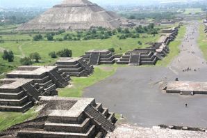
Teotihuacan

Teotihuacan

Other archaeologists, working at Teotihuacan, close to Mexico City, have been turning their attention away from how the upper classes lived (and ruled) to focus on the lives of the ordinary residents of suburbia fifteen hundred years ago. At its height (500 AD), Teotihuacan was one of the largest cities in the world, with an estimated population of 200,000. Its elaborate water supply and drainage systems and a precisely aligned grid demonstrate masterful urban planning. The city was so prominent that it became a magnet for craftsmen from other far-away regions like Oaxaca and the Gulf Coast (Veracruz). These migrants would have brought their own food ideas and preferences with them, making Teotihuacan an excellent choice for a cosmopolitan eating experience.

What most visitors to this ancient city today do not appreciate is how the average Teotihuacanos lived, how they cooked, and what they ate. But, between 1985 and 1988, cleverly conceived and executed fieldwork by a team directed by Linda Manzanilla of the National University (UNAM), unearthed a wealth of information about ancient food storage, preparation methods and kitchens. Manzanilla has demonstrated that age-old kitchens in Teotihuacan can be located by a combination of traditional archaeological methods (collecting artifacts, debris, pollen and food remains) alongside the microscopic and chemical analysis of the stucco floors in the multi-room apartment complexes used as residences and workshops.

It was already known that the stucco used on floors can absorb, over time, trace amounts of chemicals that serve as indicators of the predominant activities carried out in the room. Soil samples were taken from each square meter of floor and then analyzed for certain key indicators.

High levels of phosphates revealed areas where organic refuse was abundant. This could be a place where food was consumed, or where refuse was discarded. An elevated level of carbonates was assumed to reflect either a place where stucco was processed, or somewhere where tortillas were prepared. The tortilla-making process today still involves the liberal application of lime. A localized higher alkaline reading from the stucco floor was correlated to the location of heat or fire. The color of the soil samples was also checked for any indication of the limits of a particular activity.

Once an outline of the distribution of particular activities had been sketched out, the presence of sodium and iron was investigated. High levels of iron, for example, probably indicate where agave was processed, or where animals were butchered.

The end result? By correlating the various lines of evidence from this particular sixth century apartment, Manzanilla was able to pinpoint the precise locations of many everyday household functions. For instance, three areas where ceramic stoves once stood were distinguished. Each had a dark red stain on the floor, with relatively low carbonate values, relatively high alkalinity, and some ash. Significantly higher phosphate values in a band around this zone suggested an area used for eating. Higher phosphate levels were also encountered outside the dwelling where any refuse had been swept or accumulated.

And what was cooked on these stoves? We can not be certain, but evidence suggests that the residents of Teotihuacan had a varied diet of plants and animals. They not only prepared corn, beans, squash and chiles, but also ate cacti (prickly pear), hawthorns and cherries. For additional protein, rabbits, deer, duck, dogs, turkeys and fish were all on the menu, at least occasionally.

And, lest you think their likely diet sounds too bland, the locals also had access to potatoes and a plethora of herbs and spices, as well as chocolate, chewing gum and tobacco to satisfy their cravings, and various exotic hallucinogens to stimulate their imaginations!

So, next time you savor Mexican food, pause for a moment and remember that your meal may be startlingly similar to a banquet eaten thousands of years ago in any major Aztec, Toltec or Maya city…

Further reading

Manzanilla, Linda (1996) Soil analyses to identify ancient human activities. Canadian Journal of Soil Science.

The original article on MexConnect

Mexico’s first cooks and the origins of Mexican cuisine

 Other  Comments Off on Mexico’s first cooks and the origins of Mexican cuisine
Jun 182010
 

Mexican cuisine has been one of the country’s most successful cultural exports over the past twenty years or so and most large towns in North America and Europe now boast at least one Mexican restaurant, even if the menu is not necessarily “authentic”. For those wanting to experiment, the basic ingredients for Mexican meals can now be bought virtually everywhere. The increasing popularity of Mexican food has been rivaled only by an extraordinary increase in the consumption of Mexican drinks, including Corona beer and tequila.

Ingredients for guacamole. Photo: Chef Daniel Wheeler. All rights reserved.

Archaeologists have also taken much more interest in Mexican food in recent years.

By 1970, studies carried out at various locations, ranging from Tamaulipas in the north of the country to Oaxaca in the south, had gradually led to the conclusion that the earliest plants to be domesticated in Meso-America were corn, beans and squash, and that all three had been domesticated between about 7000 and 10,000 years BP (Before Present, not British Petroleum…).

Further research subsequently led most archaeologists and palaeo-botanists to believe that squash was actually domesticated much earlier than corn. Re-evaluating cave samples, originally collected in the 1950s, using an improved carbon-14 dating technique, anthropologist Bruce Smith found that the squash seeds from one location were between 8,000 and 10,000 years old, while the oldest corn and bean seeds were much younger, less than 6,000 years old.

While Smith’s study does appears to confirm that squash was domesticated first, it does not necessarily mean that this squash was domesticated for its food value. Many experts think that early varieties of squash may have been domesticated primarily for their gourds, which could be used as ready-made drinking vessels and fishing floats.

The domestication of squash may have improved life, but it did not fundamentally change it. On the other hand, the eventual domestication of corn, about 7,000 years BP marked a true watershed in pre-Hispanic life, enabling the abandonment of a nomadic hunter-gathering existence in favor of settlement in semi-permanent villages. How important was this? In the words of renowned archaeologist Michael Coe, “it was the cultivation of maize, beans and squash that made possible all of the higher cultures of Mexico.”

With the passing of time, the ancient peoples of Mexico domesticated and cultivated many other native plants, including tomatoes, chiles, potatoes, avocados, amaranth, chayote (vegetable pear), cotton and tobacco.

The original article on MexConnect

If you enjoyed this post, you might also enjoy Geo-Mexico: the geography and dynamics of modern Mexico.

Jun 092010
 

On January 1, 1846, the Criollo leaders in Merida declared independence as the Republic of the Yucatán for the third time. In 1847, the Caste War broke out when the Mayas rebelled against the Criollo upper class that controlled the Yucatán Republic. They drove most of the Criollos out of the Peninsula except for the those behind the walls surrounding Mérida and Campeche City.

With their back to the wall, the Yucatan Republic offered sovereignty over to Yucatán to either USA or Britain or Spain, whichever was first to effectively end the Maya revolt. In a desperate effort to put down the rebellion, the Yucatán Criollos agreed on 17 August 1848 to re-unite with Mexico if the Mexican army would put down the Maya rebellion. With fresh Mexican troops, they retook control over northwestern portion of the Peninsula. However, Mayas maintained control of the southeast for the rest of the 19th century and beyond. Skirmishes continued on and off for more than 70 years. Maya independent control of some parts of the southeastern Yucatán Peninsula did not end until after the Mexican Revolution.

See also:

The Republic of the Yucatán

 Other  Comments Off on The Republic of the Yucatán
Jun 042010
 

After independence in 1821, the Federated Republic of Yucatán joined the Mexican federation in May 1823.  The new republic comprised the whole Yucatan Peninsula including what is now the states of Campeche and Quintana Roo.  It maintained a degree of autonomy in the Mexican federation.

In the mid 1830s President Santa Anna imposed a centrally controlled dictatorship, which imposed significant control over Yucatán.  This lead to a rebellion in 1838 seeking Yucatán independence. Negotiations with Santa Anna to give Yucatán more autonomy within the Mexican Republic stumbled.

In 1840 the Yucatán declared full independence as the Republic of the Yucatán. At the time, Santa Anna was preoccupied with rebellions in northern Mexico, but he did blockade Yucatán ports. At the time, there were no land routes between the Yucatán and either Mexico or Central America. In 1843 Mexico sent troops to Yucatán to put down the rebellion. They failed, but the blockade was successful. The young Republic had no navy and no way to trade because its ports were successfully blockaded. It agreed in December 1843 to rejoin Mexico when given assurances of self-rule.

But the assurances of self-rule were not upheld and the Yucatán declared independence again on January 1, 1846. When the Mexican–American War broke out later that year, Yucatán declared neutrality. While Mexico had its hands full fighting the USA, the Yucatán had its own problems. In 1847 the Mayas initiated the Caste War by rebelling against the Hispanic (Criollo) (creole) upper class that controlled the Yucatán Republic.

With its back to the wall in early 1848, the Yucatán Republic offered sovereignty over Yucatán to either USA or Britain or Spain, whichever was first to effectively end the Maya revolt. The USA invoked the Monroe Doctrine to keep the other two out and seriously considered the proposal, but in the end did not accept it.

In a desperate effort to put down the rebellion, the Yucatán Criollos agreed on 17 August 1848 to re-unite with Mexico if the Mexican army would put down the Maya rebellion. Thus the on and off  life of the Republic of the Yucatán came to an end. The peninsula remained relatively separate from the rest of Mexico. The first railroad link was established in the 1950s (see earlier post about the first map on a Mexican postage stamp) and the first highway in the 1960s.

See also:

Aguascalientes’ geopolitical romance and long road to Statehood

 Excerpts from Geo-Mexico  Comments Off on Aguascalientes’ geopolitical romance and long road to Statehood
May 312010
 

How did the State of Aguascalientes come to be so small, and sandwiched between much larger states?

Aguascalientes coat-of-arms

The area that is now the State of Aguascalientes was caught between the colonial jurisdictions of Jalisco and Zacatecas.  Prior to the Mexican Revolution it was considered part of Zacatecas, but after the War of Independence, in 1821 it gained status as its own political entity. This lasted only a few years. In 1824 it became part of the State of Zacatecas.

A decade later, in 1835, Zacatecas rebelled against the Federal Government.  General Santa Anna and his army squashed the rebellion, ransacked the City of Zacatecas and seized large quantities of the state’s silver. As payback for the rebellion, the Mexican Legislature separated the agriculturally-rich Aguascalientes Territory from the State of Zacatecas.

The more romantic version is that, “the independence of Aguascalientes was sealed with a kiss, as the locals are invariably quick to point out.”  (Tony Burton, Western Mexico: A Traveler’s Treasury). While quelling the Zacatecan rebels, General Santa Anna met the beautiful Doña María Luisa Villa, the wife of the Aguascalientes’ mayor. Santa Anna was very attracted to her and promised her anything for a kiss. He got the kiss and fulfilled her promise by making Aguascalientes an independent territory under the governorship of her husband, Pedro García Rojas. Hence, the lips on the state’s coat-of-arms!

Detail from Aguascalientes coat-of-arms (Note the lips!)

But Aguascalientes’ independence did not last long. In 1847, the national legislature revoked its independence and put it back into the State of Zacatecas. However, a few years later in 1853, Aguascalientes regained independent status. Finally, under the new Mexican Constitution of 1857, Aguascalientes became Mexico’s 24th state, with the colonial city of Aguascalientes as its capital.

Aguascalientes is a rather small state. Among Mexican states it ranks in the lower 20% in both areal size and population (about 1.2 million).  Most of the population (over 900,000) lives in the industrial Aguascalientes Metropolitan Area.  Locals claim that the Aguascalientes Nissan plant is the largest outside of Japan.

The evolution of Mexico’s political boundaries is discussed in chapter 9 of Geo-Mexico: the geography and dynamics of modern Mexico.

Apr 012010
 

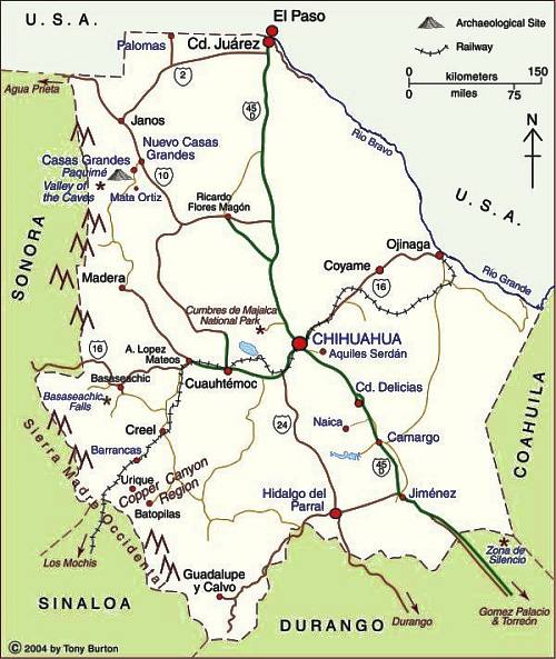
The map shows the state of Chihuahua in northern Mexico. The state capital is the city of Chihuahua (2009 population: 839,000) . Chihuahua is the largest state in Mexico in area: 247,087 square kilometers  (95,401 square miles). The state’s population is 3,422,047 (CONAPO 2010 estimate).

Cd. Juárez is the state’s largest city and Mexico’s 8th largest city with a population of about 1.4 million. In recent years, the city, across the border from the US city of El Paso, has gained considerable notoriety on account of its violence and high murder rate. It also faces air pollution issues, discussed in chapter 23 of Geo-Mexico: the geography and dynamics of modern Mexico.

Map of Chihuahua. Copyright 2004, 2010 Tony Burton. All rights reserved.

The state of Chihuahua has several important tourist attractions, including:

  • the Copper Canyon region (narrower, deeper and longer than the US Grand Canyon) which is home to the Tarahumar Indians, an indigenous group with a particularly distinctive lifestyle. The Copper Canyon and Tarahumar Indians are discussed in chapters 13, 17 and 19 of Geo-Mexico. A world-famous tourist train traverses this region.
  • Mexico’s two highest waterfalls, the Piedra Volada Falls, where the water tumbles 453 meters (1,486 feet) and the Basaseachic Falls, which are  246 meters  (807 feet) in height. The Piedra Volada Falls, which are seasonal, are not shown on this map, but are a short distance north of the Basaseachic Falls.
  • The Casas Grandes area with its important archaeological site
  • Mennonite farming areas; their distinctive landscapes are discussed in chapter 11 of Geo-Mexico
  • Many sites associated with famous revolutionary figure Pancho Villa, including his former 50-room mansion, now a museum, in the state capital

Click here for the interactive version of this map on MexConnect website.

Canadian Club of Ajijic listens to Geo-Mexico co-author

 Other  Comments Off on Canadian Club of Ajijic listens to Geo-Mexico co-author
Jan 152010
 

More than 300 people packed the grounds of La Nueva Posada hotel in Ajijic, Mexico, to hear Geo-Mexico co-author Tony Burton talk about the significance of 2010 in Mexico. Burton took an historical approach, exploring both the history of geography and the geography of history while comparing many aspects of Mexico in 1810 (Independence), 1910 (Revolution) and 2010. His entertaining and informative talk, which was largely based on material in Geo-Mexico, was well received.
At the end of his talk, Burton highlighted the fact that Mexico’s population projections for 2050 suggest that the country will have moved from a predominately young to an elderly population in only one or two generations.