The Ghost Train (El Tren Fantasma): a case study of the geography of sound in Mexico

 Books and resources, Other  Comments Off on The Ghost Train (El Tren Fantasma): a case study of the geography of sound in Mexico
Oct 162014
 

Geography is not only about things that can be seen, touched and measured. Many branches of geography consider how people think, how communities make decisions and how nations interact.

At a local scale, one of the characteristics that is often overlooked is sound. We often ignore the soundscapes of places, either because we are “too busy” to listen and take in the local sounds, or because we are “too busy” tuning any distinctive local sounds out while using our cell phones or listening to favorite music.

Soundscapes vary greatly from rural areas to urban areas, and from one region to another; Mexico’s urban soundscapes are among the most distinctive on the planet.

In previous posts, we listened to The distinctive sounds of Mexico’s towns and cities; covered our ears as we analysed Noise pollution in Mexico; and also described the amazing Whistled language of the Chinantec people in Oaxaca.

In this post, we take a look at Chris Watson’s intriguing 2011 album “El Tren Fantasma”:

U.K.-based Chris Watson is a preeminent freelance recordist of wildlife and natural phenomena, whose work has been featured in many BBC programs including David Attenborough’s series, The Life Of Birds. As Watson has remarked, sound recording allows you to put a microphone where you can’t put your ears, to enable you to listen to sounds such as the groaning ice of a moving glacier. His work for the BBC was audio vérité but more recently, including in El Tren Fantasma, Watson has experimented with post production techniques to meld field recordings into a narrative.

The result is strangely compelling, dramatic and in some respects, awesome!

The soundscapes of El Tren Fantasma (the title is identical to that of a 1927 Mexican movie) offer a trip from the Pacific Coast to the Gulf Coast of Mexico condensed into little more than an hour.

The first six tracks cover the section of railway best known as the Copper Canyon line, one of the few remaining routes in Mexico with regular passenger service.

El Tren Fantasma has 10 tracks (pun intended):

  1. La Anunciante
  2. Los Mochis
  3. Sierra Tarahumara
  4. El Divisadero
  5. Crucero La Joya
  6. Chihuahua
  7. Aguascalientes
  8. Mexico D.F.
  9. El Tajin; El dia y La noche
  10. Veracruz

If you don’t have time to listen to all 10 tracks, the most interesting, from a geographical point of view, are probably the following:

The trip was nicknamed the ghost train by Watson because there are no longer any passenger trains connecting the two coasts. Several years ago, Watson was the sound recordist for a film crew making a program in the BBC TV series Great Railway Journeys. Even then, part of the line was freight only, but in earlier times, there had been regular scheduled passenger trains across the country.

The promotional material asks potential listeners to, “Take the ghost train from Los Mochis to Veracruz and travel cross country, coast to coast, Pacific to Atlantic. Ride the rhythm of the rails on board the Ferrocarriles Nacionales de México (FNM) and the music of a journey that has now passed into history.”

“In this album, the journey of the ‘ghost train’ is recreated, evoking memories of a recent past, capturing the atmosphere, rhythms and sounds of human life, wildlife and the journey itself along the tracks of one of Mexico’s greatest engineering projects.”

Reviews were almost universally positive.

Several reviewers recognized the connection between the soundscapes of El Tren Fantasma and geography, in some cases also attributing reasons for the decline of passenger train services in Mexico. For example Martin Hoyle, writing in The Financial Times, described how “From desert to rainforest, hummingbirds’ wings to the boom of heat rising from the Copper Canyon, it recalls a beloved passenger train system abandoned by privatisation.”

Pete Naughton in The Daily Telegraph wrote that the sound portrait painted by Watson “jostles with human, animal and mechanical life, filling the room with an atmosphere that is more richly evocative of Central America than any TV travel show I’ve seen. Diesel engines thrum, cicadas chirrup and passengers chatter, sing and argue.”

A reviewer in The Milk Factory (UK) drew attention to the “tremor of excitement as the sound of a diesel engine temporarily swallows the clunking noise of metal on metal and the strident hisses as wheels grind again rails and breaks against wheels”, before adding that, “Watson doesn’t aim to recreate the journey in any consistent chronology. Instead, he gives a taste of what this journey actually was by using nature and wildlife sounds to hint at the landscapes passed on the way.”

Spencer Grady, reviewing El Tren Fantasma for BBCi (UK), wrote that: “While Chris Watson’s previous sets – such as 2003’s critically acclaimed Weather Report – have generally concerned themselves with this planet’s myriad beasts and habitats, this narrative inevitably bears an anthropological mark. Indeed, the first voice we hear doesn’t belong to a cuckoo or coyote, but station announcer Ana Gonzalez Bello putting out one “last call for the ghost train”. It’s an unusually contrived opening gambit, from which point the listener is jettisoned into a collision of screeching breaks, rolling stock rattle and hot hydraulic huff. Over half of El Tren Fantasma’s tracks (pun definitely intended) are given over to locomotive sound – gears shifting, hoots, bells and whistles – climaxing with El Divisadero, where Watson manipulates the monolithic machinations into a surging, phantasmal bellow, like a choir of angels struggling to be heard over the rumbling thrum of running gear.”

For an academic geographer’s perspective on El Tren Fantasma, a good place to start (for those with academic library access) is a recent issue of Transactions of the Institute of British Geographers (Vol 39, No 3, 2014). In “El tren fantasma : arcs of sound and the acoustic spaces of landscapes”, George Revill, of the Open University, draws on Chris Watson’s soundwork “El tren fantasma” to consider “how sound participates in the production of the railway corridor as a complex, animate and deeply contoured historically and geographically specific experience of landscape.”

El Tren Fantasma offers an extraordinarily evocative sound summary of a trip across Mexico; what a shame that there are now so few passenger services left on Mexican railways!

Related posts:
How can tourism perception be assessed? A case study using the Lerma-Chapala drainage basin

 Books and resources, Teaching ideas  Comments Off on How can tourism perception be assessed? A case study using the Lerma-Chapala drainage basin
Aug 282014
 

In numerous previous posts, we have looked at the importance of tourism in Mexico, and have examined its impacts at different scales, from the national/international scale at one extreme to the single resort scale at the other:

National scale:

Sub-national regional scale:

Single resort scale

We have also considered the way in which the characteristics of tourism in a resort change over time:

Attempting to quantify the importance or impacts of tourism, beneficial or otherwise, is fraught with methodological difficulties. The number of hotel rooms in different cities is often used as a proxy measure of the relative importance of tourism in different communities, but looking only at tourist capacity “masks  the fact that hotels are rarely full. In 2007, the national occupancy rate was 54.8%. Traditional beach resorts such as Acapulco, Mazatlán and Puerto Vallarta had an occupancy rate of 52.2%, compared to 68.1% for modern, planned mega-resorts like Cancún and Los Cabos. The occupancy rate in the large cities—Guadalajara, Mexico City and Monterrey—was 55.0%, well ahead of the 47.2% for other interior cities.” (Geo-Mexico, p 134).

As in other branches of geography, it is not only the “reality” that matters, but also people’s perceptions of reality. Most decisions concerning location (such as where to live, the best place to start a new business. etc) are taken on imperfect or incomplete information; in other words, these decisions are based, at least to some extent, on perceptions.

In the case of tourism, it is the perception of visitors that matters. This is precisely why certain resorts gain a reputation as being “jet set” or the “in place” to vacation. The “in place” today is not going to be the “in place” in a few year’s time, since perceptions (and reality) change. Nowhere has this proved to be more true in Mexico than in the case of Acapulco.

But is it possible to measure tourist perceptions? It is very difficult to do so directly, but there are ways of tackling this question, and here we look at one approach, based on an analysis of tourist-oriented literature.

The approach is easiest to explain in the context of a real example, in this case an analysis of the likely perception of foreign tourists of destinations in the Lerma-Chapala drainage basin in Mexico. (This study formed part of my contribution on tourism to the Atlas de la cuenca Lerma-Chapala, construyendo una visión conjunta, Semarnat-Unam-IE, 2006 – the link is to a low-resolution pdf of the entire atlas).

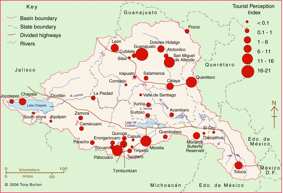
The Lerma-Chapala Basin (see map) is one of Mexico’s major river systems, comprising portions of 127 municipalities in five states: México, Querétaro, Michoacán, Guanajuato and Jalisco. The basin has considerable economic importance. It occupies only 2.9% of Mexico’s total landmass, but is home to 9.3% of Mexico’s total population, and its economic activities account for 11.5% of national GDP. It also has considerable importance for tourism.

Lerma Basin Tourist Perception Index.

Lerma Basin Tourist Perception Index. Cartography: Tony Burton / Geo-Mexico; all rights reserved Click to enlarge.

The red circles superimposed on the map represent an index of tourism perception. This index is based on an analysis of seven tourist guides that purport to cover the entire country:

  • AAA Tourbook (2004)
  • Let’s Go Mexico (2004)
  • Lonely Planet (2002)
  • Footprint Guide (1999)
  • Upclose Mexico (1998)
  • Insight Guide (1994)
  • Cadogan Guide (1991)

In each case, the total number of lines of text in the guide devoted to any location within the Lerma-Chapala drainage basin was counted, as well as the number of lines devoted to each individual location. This allowed a ratio or percentage to be worked out for each place for each book. For example, if a book had 240 lines in total devoted to the drainage basin, of which 60 were devoted to San Miguel de Allende, the perception index for San Miguel for that book would be 60/240 * 100 = 25%. Similar calculations were performed for all the locations mentioned, for each book, and then the mean index was calculated for each location. These mean indices were the basis for the size of the circles on the map.

In broad terms, the map shows which places are likely to be on a foreign traveler’s radar when they are visiting the area. Those familiar with this area may be surprised to see that the ghost town of Pozos merits as many lines of text as Quiroga (and indeed more lines of text than Atotonilco). Another surprise is that Tzintzuntzan appears to be as much in the tourist eye as Chapala, Dolores Hidalgo or Toluca. The main purpose of this post is not to analyse such apparent anomalies but only to suggest a relatively easy way of analysing tourist perceptions through the use of tourist-oriented literature. Applying the same method to the entire country, on a state-by-state basis, throws up far more interesting anomalies which we plan to share at some point in the future.

Related posts:

Related posts:

Apr 032014
 

Geo-Mexico agrees entirely with Joseph Kerski (a key member of ESRI’s Education Team), that it is amazing “how little American students really know about their neighbor to the south.” In order to help remedy this situation, ESRI’s Witold Fraczek has created a series of online “story maps” about Mexico. The maps can be accessed in several different ways, including as an ArcGIS Online presentation and an iPad iBook, or via this webpage.

The six stories are entitled:

Each “story” includes several maps (covering topics such as population, landforms, climate, historical landmarks, caves, indigenous cultures, tourist attractions), some of which are interactive in the sense that clicking on a marked point brings up a pop-up panel with a photograph and/or additional information about that place. The maps, linked by short commentary notes, can be viewed at a variety of scales.

This series of maps has many strong points, and could certainly be useful in some geography classes, but it also has some weaknesses that should be taken into account when using them. Brief comments follow on each of the six stories.

1 Explore Mexico (Crime vs. Tourism)

The first map in this mini-series depicts “tourism attraction density” based on “650 major points of interest”. No clues are offered as to how the 650 points were selected, and indeed, some can not really be shown by points on a map since they cover larger areas. The map appears to weight all 650 points equally, though some are major, major tourist attractions (like the pyramids of Teotihuacan) that attract thousands of visitors a day, while others are very much less significant.

The second map, showing the “20 cities with most murders” uses data from 2011 (now out-dated) to conclude that “crime, measured by the total number of murders” appears to be “spatially isolated from the areas most attractive to tourists”. Surely murder rates (per 100,000 people) are a better measure than the number of murders in each city?

Murder rate per 100,000 is used as the basis for comparing Mexico with its regional neighbors, but Mexico is so large (and the murder rates across the country so varied) that comparisons at this scale mean relatively little, especially when some of the nations are tiny Caribbean islands, where one or two murders extra in any year can mean a significant spike in their murder rate.

2. Mexico’s Natural Wonders

The introductory text to this section rightly highlights how “the natural world of Mexico varies amazingly, from tropical jungles and coral reefs to deserts and glaciers.”

However, the statement that “Central Mexico is home to billions of Monarch Butterflies, whose 2 year /4 generation long trip to Canada and back amazes both scientists and the general public” is misleading. First, there may be millions of Monarch Butterflies, but there are not billions. Secondly, not all Monarch Butterflies migrate. Thirdly, those that do migrate are part of an annual (1 year) cycle involving 4 or 5 generations, not a two year cycle.

The text later claims that the Monarch Butterfly reserves “are located on old volcanic hills covered with pine-oak forest”. Actually, they overwinter in pine-fir forests. Mexico’s pine-oak woodlands occur only at much lower elevations.

The only birds incorporated into Mexico’s “biological wonders” are its pink flamingos, yet there are dozens of other bird species that are equally worthy of inclusion. Fortunately, the texts accompanying the maps of caves and cenotes (sinkholes), waterfalls, volcanoes, canyons and geologic sites appear to be much more accurate.

Screenshot from ESRI's story maps of Mexico.

Screenshot of ESRI’s story maps of Mexico.

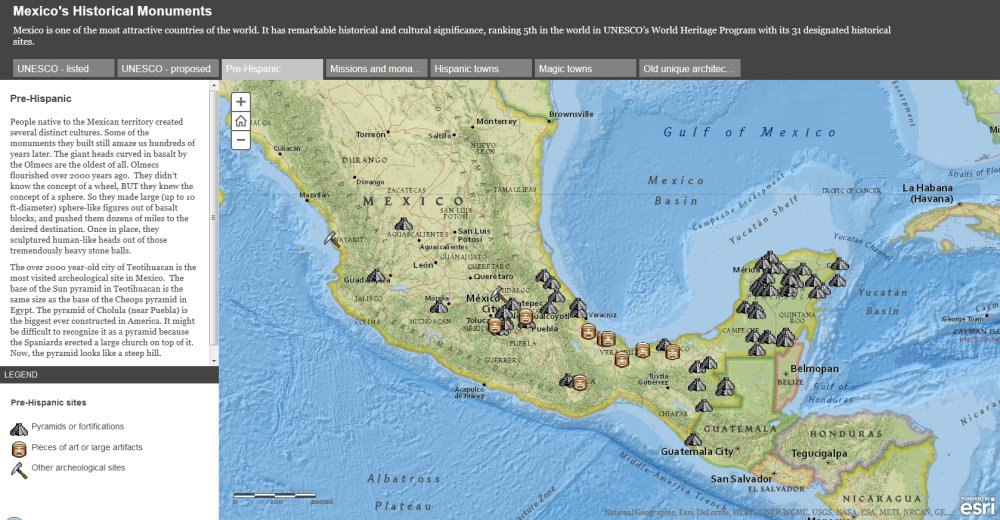
3. Historical monuments

This section includes a useful map of Mexico’s World Heritage sites, though absent (from both the declared sites and the proposed sites) is the El Pinacate and Gran Desierto de Altar Biosphere Reserve in Sonora, which in June 2013 became Mexico’s 32nd World Heritage Site.

The great weakness of the maps of “archaeological sites” and “missions and monasteries” is that no clues are given as to how and why particular locations were selected for inclusion. This leads to some anomalies in the distribution. For example, Oaxaca is almost a no-show for “missions and monasteries” according to the map, despite such buildings being the subject of an excellent and extensive book by Richard Perry published as long ago as 2006, Exploring Colonial Oaxaca: The Art and Architecture.

The map of Magic Towns is also a useful map, though many more towns have been added to the list since 2012.

4. Geography of Mexico – Did You Know?

This series of maps will be quite useful to many classes as a quick way to introduce the basic physical and settlement geography of the country. Maps of relief and precipitation are accompanied by one of time zones and a simple map of states (though these are not named on the “map story” version) and major cities.

The introductory text to this section claims that “the array of Mexican volcanoes stretches along the same latitude as the volcanoes of Hawaii. Analogously, those located at the eastern ends are the newest and highest.” This may be true for Hawaii, but is not the case for Mexico. There is no simple pattern to the heights of Mexico’s major volcanoes, and certainly those in the east are not significantly younger than those in the west.

5. Indigenous People of Mexico

The single map in this section attempts to show the location of about 25 of Mexico’s many indigenous groups. The colors chosen for each group are in many cases confusingly similar, though the names of each group do appear as you zoom in on parts of the map.

The introductory text makes a strong case for Mexico’s attractiveness to tourists, yet concludes with the strange (and unanswered) question, “So why isn’t Mexico a major tourist destination?” Mexicans would beg to differ. Mexico is a major tourist destination. In 2013, for example, it received 23.7 million international visitors who spent 13.8 billion dollars. In fact, Mexico is ranked #11 in the world in terms of tourist arrivals (and that number excludes the 70 million or so border tourists each year).

6. Cartograms of Mexico

The cartograms in the last section certainly add interest to the map stories, but the basis of the “travelers attractiveness” map (those 650 tourist attractions again) means that the map is not a very good reflection of tourist numbers across the country. The significance of the State of Mexico is greatly exaggerated, while states such as Quintana Roo (with the resort of Cancún) and Baja California Sur (with Los Cabos) fail to stand out.

The final “fictional map” purports to portray Mexico as perceived by Californians. Based on the author’s personal impressions, in some ways this is the single most interesting map in the entire collection!

All in all, these maps are a mixed bag. The idea behind them is great, as is the decision to produce them in a flexible GIS system. If the details were refined a little, and more explanation offered about the basis for selecting places for inclusion, they would be even more useful in geography classes, and might go some way towards helping American students gain a better appreciation for their southern neighbor.

Perceptions of Mexico, from popular images to the “real” Mexico

 Other, Teaching ideas  Comments Off on Perceptions of Mexico, from popular images to the “real” Mexico
May 182010
 

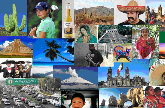
What comes to mind when the word “Mexico” is mentioned?

For most people, it brings to mind a variety of colorful images, such as those below, usually based on television, magazines, travel brochures and personal travels in Mexico. “Mexico” also is associated with verbal or written words or phrases, such as:

  • Drug wars
  • Illegal immigrants
  • Tacos and tamales
  • Tequila / Good beer
  • Fabulous beach resorts
  • Bargain prices
  • Poverty
  • Friendly people
  • Carlos Slim (the World’s richest man)
  • Deserts and cactus
  • Swine flu
  • Pre-Columbian ruins
  • Sombreros
  • Geo-Mexico (well maybe that last one is wishful thinking, but hopefully it will true someday)

Q. How many of these images can you identify?

These images and word phrases hold some truth, but do not begin to capture the full importance and significance of Mexico, something we try to do more thoroughly in Geo-Mexico: the geography and dynamics of modern Mexico.

For example, did you know that Mexico is one of only six countries ranked in the top 15 in the world in geographic size, population, and economic production? Furthermore, Mexico is one of the earth’s most biologically diverse countries. It ranks first in number of reptile, cactus and pine species; second in mammal species; and fourth in amphibian species.

There is lots more to Mexico than meets the eye in magazine and TV adverts – and that’s why you should consider buying your own copy of Geo-Mexico: the geography and dynamics of modern Mexico, rather than relying on your local library or extracts posted on this blog!