The West Rail Bypass International Bridge, a new USA-Mexico rail link

 Mexico's geography in the Press  Comments Off on The West Rail Bypass International Bridge, a new USA-Mexico rail link
Nov 032015
 

The flow of bilateral Mexico-USA trade has increased six-fold in value in the past 20 years to nearly 1.5 billion dollars a day; 80% of it moves by truck or rail. A new rail bridge, the West Rail Bypass International Bridge (WBR), opened in late August, capable of carrying up to 24 million metric tons of freight a year, which should help reduce delays in trans-border trade.

West Rail Bypass International Bridge.

West Rail Bypass International Bridge. Credit: Cameron County

The WBR links Matamoros (Tamaulipas) to Brownsville (Texas). It took four years to build and is the first new rail link between Mexico and the USA for more than a century. The bridge can be used by 14 trains a day and replaces a rail line that previously wound its way, with frequent delays, through a heavily congested urban area.

In an unrelated effort to speed up trans-border shipments, Mexican and U.S. officials are testing a single, joint customs inspection procedure that could cut border-crossing times for freight by up to 80%.

The program is being tested at three locations:

  • Laredo international airport in Texas (for vehicle, electronic and aerospace components being flown to eight cities in Mexico),
  • Mesa de Otay in Baja California (for Mexican farm products entering the U.S.) and
  • San Jerónimo in Chihuahua (for computers and other electronic exports from Mexico).

Assuming the six month pilot project is successful, costly border delays for some trans-border shipments could soon be a thing of the past. The project has been warmly welcomed by AmCham, the American Chamber of Commerce in Mexico, which represents more than 1,400 companies.

Related posts:

The spatial development of Mexico’s railway network

 Excerpts from Geo-Mexico  Comments Off on The spatial development of Mexico’s railway network
Dec 202014
 

At the end of the nineteenth century, during the successive presidencies of Porfirio Díaz, railway building leapt forward. Díaz aggressively encouraged rail development through generous concessions and government subsidies to foreign investors. By 1884 Mexico had 12,000 km of track, including a US-financed link from Mexico City to the USA through Torreón, Chihuahua and Ciudad Juárez. A British company had completed lines from Mexico City to Guadalajara, and from Mexico City via Monterrey to Nuevo Laredo.

Fig. 17.2 The development of Mexico's railway network

Fig. 17.2 The development of Mexico’s railway network. Copyright: Geo-Mexico; all rights reserved

By the start of the twentieth century, additional tracks connected Guadalajara, San Luis Potosí and Monterrey to the Gulf coast port of Tampico. A line connecting the Pacific and Gulf coasts was also completed. Durango was now connected to Eagle Pass on the US border. A second line to Veracruz was constructed, with a spur to Oaxaca. Laws passed in 1898 sought to bring order to the rapid and chaotic expansion of Mexico’s rail system. Foreign concessions were restricted. Subsidies were only made available for the completion of missing links such as lines to Manzanillo and the Guatemala border. Efforts were made to standardize track gauges.

After the Revolution, network improvements were hindered by poor administration, corruption, labor unions and a shift of government priority to roads. The west coast railroad from Sonora to Guadalajara was completed in 1927. The Yucatán Peninsula was joined to the national network in the 1950s and the famous Chihuahua to Los Mochis line through the Copper Canyon was completed in 1961, finally linking Texas and Mexico’s northern plateau to the Pacific Ocean.

Related posts:

Dec 062014
 

In the second half of the 19th century, the Mexican government undertook am ambitious railway building program that eventually connected Mexico City with the USA, as well as with ports on the Atlantic Ocean and Pacific Ocean

Since the privatization of the railway system in 1995, many lines have fallen out of use and passenger services have been all but abandoned, leaving hundreds of kilometers of disused track and isolating some rural communities from the nearest large city. Much of Mexico’s historic railway infrastructure now lies in ruins.

In the past decade, some former railway lines have been turned into walking and cycling trails. For example:

The state of Jalisco has started to recondition 120 kilometers of former railway routes as Green Route (Via Verde) trails for non-motorized traffic (hikers, cyclists, horse riders). Many of the old stations along these routes will be restored to provide essential services and exhibition space. The former train station in Ameca (on the extreme northern edge of the town) has been renovated to serve as the start of one of these routes, with exhibits focusing on the history of the railroad, local fiestas and the region’s haciendas. The lovely building, dating back more than a century, witnessed its last train in 1995.

Given that the railways played such a key role in the Revolution, enabling both sides to move troops quickly around the country, it is fitting that they are now the basis for this new revolution involving cultural tourism. (Western Mexico, A Traveler’s Treasury, p 61).

Others lines, elsewhere in Mexico, have been explored by two intrepid Mexican artists as part of an unusual geo-art project. Artists Ivan Puig and Andres Padilla Domene built a vehicle capable of traveling on train tracks and explored some of the country’s abandoned railway lines. As they went, they photographed hundreds of ruins and recorded hours of interviews with people they met. They later did something similar in Ecuador, but that’s another story.

Their striking silver road-rail vehicle is known as SEFT-1, where SEFT stands for Sonda de Exploración Ferroviaria Tripulada (Manned Railway Exploration Probe).

seft-1

The artists recorded their experiences in videos, photographs and collected objects. Interviewing people they met, often from communities isolated by Mexico’s passenger railway closures, they shared their findings online, where audiences could track the probe’s trajectory, view maps and images and listen to interviews.

Their first London (UK) exhibition, SEFT-1 Abandoned Railways Exploration Probe – Modern Ruins 1:220, was commissioned by The Arts Catalyst and presented at the Furtherfield gallery space in the heart of Finsbury Park. In the exhibit, the artists explore how the ideology of progress is imprinted onto historic landscapes and they also reflect on the two poles of the social experience of technology: use and obsolescence.

For this exhibition, the artists also invited British expert model railway constructors to create scale reproductions of specific Mexican railway ruins exactly as they had found them. One gallery became a space for the process of model ruin construction. The room’s walls displayed the pictures, documents, plans and other materials used as reference for the meticulously-elaborated models.

The Artists

Ivan Puig (born 1977, Guadalajara) has exhibited internationally in Mexico, Germany, Canada, Brazil and the USA. Puig, a member of the collective TRiodO (with Marcela Armas and Gilberto Esparza), lives and works in Mexico City.

Andrés Padilla Domene (born 1986, Guadalajara) has exhibited work in Mexico, the USA and Ecuador. His video work as director and producer with Camper Media includes documentaries, fiction films and TV shows.

Related posts:

Mexico’s golden age of railways

 Excerpts from Geo-Mexico  Comments Off on Mexico’s golden age of railways
Nov 302014
 

Early concessions (the first was in 1837) came to nothing. By 1860 Mexico had less than 250 km of short disconnected railroad lines and was falling way behind its northern neighbor, the USA, which already had almost 50,000 km. Political, administrative and financial issues, coupled with Mexico’s rugged topography, also prevented Mexico from keeping up with other Latin American nations. Mexico City was finally linked by rail to Puebla in 1866 and Veracruz in 1873.

In deciding the best route for the Veracruz-Mexico City line, Arthur Wellington, an American engineer, developed the concepts which later became known as positive and negative deviation. At first glance, it might be assumed that the optimum route for a railway is the shortest distance between points, provided that the maximum possible grade is never exceeded. Negative deviations lengthen this minimum distance in order to avoid obstacles such as the volcanic mountains east of Mexico City: the Veracruz line skirts the twin volcanic peaks of Popocatepetl and Ixtaccihuatl before entering Mexico City from the north-east. Positive deviations lengthen the minimum distance in order to gain more traffic.

Detail of lithograph by Casimiro Castro of Railway near Orizaba, Veracruz

Detail of lithograph by Casimiro Castro of Railway near Orizaba, Veracruz

At the end of the nineteenth century, during the successive presidencies of Porfirio Díaz, railway building leapt forward. Díaz aggressively encouraged rail development through generous concessions and government subsidies to foreign investors. By 1884 Mexico had 12,000 km of track, including a US-financed link from Mexico City to the USA through Torreón, Chihuahua and Ciudad Juárez. A British company had completed lines from Mexico City to Guadalajara, and from Mexico City via Monterrey to Nuevo Laredo.

Different gauge tracks typified a system based on numerous concessions but no overall national plan. By the turn of the century, additional tracks connected Guadalajara, San Luis Potosí and Monterrey to the Gulf coast port of Tampico. A line connecting the Pacific and Gulf coasts was also completed. Durango was now connected to Eagle Pass on the US border. A second line to Veracruz was constructed, with a spur to Oaxaca. Laws passed in 1898 sought to bring order to the rapid and chaotic expansion of Mexico’s rail system. Foreign concessions were restricted. Subsidies were only made available for the completion of missing links such as lines to Manzanillo and the Guatemala border. Efforts were made to standardize track gauges.

However, the country’s 24,000 km railroad network still had serious deficiencies. There were only three effective connections from the central plateau to the coasts. There were no links from central Mexico to either the Yucatán Peninsula or to the northwestern states of Nayarit, Sinaloa, Sonora and Baja California. The only efficient way to move inland freight from Chihuahua, Torreón, Durango or Ciudad Juárez to the Pacific was either north through the USA or all the way south and through Guadalajara to Manzanillo. The Sonora railroad linked Guaymas and Hermosillo to the USA, but not to the rest of Mexico.

Despite their weaknesses, railroads revolutionized Mexico. The railroads had average speeds of about 40 kph (25 mph) and ran through the night. They were five to ten times faster than pre-railroad transport. They lowered freight costs by roughly 80%. They shrank the size of Mexico in terms of travel time by a factor of between five and ten. They were also much cheaper and far more comfortable than stagecoaches. The estimated savings from railroad services in 1910 amounted to over 10% of the country’s gross national product. Between 1890 and 1910, the construction and use of railroads accounted for an estimated half of the growth in Mexico’s income per person. In addition, the railroads carried mail, greatly reducing the time needed for this form of communication. Clearly, the benefits of railroads far outweighed their costs.

Foreign companies gained mightily from their investments building railroads, which were almost entirely dependent on imported locomotives, rolling stock, technical expertise, and even fuel. But Mexicans also benefited enormously; in the early 1900s over half of the rail cargo supplied local markets and industries. The railroads thrust much of Mexico into the 20th century.

Cities with favorable rail connections grew significantly during the railroad era while those poorly served were at a severe disadvantage. The speed and economies of scale of shipping by rail encouraged mass production for national markets. For example, cotton growing expanded rapidly on irrigated farms near Torreón because the crop could be shipped easily and cheaply to large textile factories in Guadalajara, Puebla and Orizaba. Manufactured textiles were then distributed cheaply by rail to national markets. Elsewhere, the railroads enabled large iron and steel, chemical, cement, paper, shoe, beer and cigarette factories to supply the national market.

On the other hand, most Mexicans still lived far from railroad lines and relied on foot or mule transport while practicing subsistence agriculture. In addition, the cost of rail tickets was prohibitively expensive for many Mexicans; paying for a 70 km (43 mi) trip required a week’s pay for those on the minimum wage. The railroads greatly expanded the gap between the ‘have’ and the ‘have not’ areas of the country. Almost all the Pacific coast and most of southern Mexico did not benefit from the railroads. Such growing inequalities contributed to the Mexican Revolution.

After the Revolution, network improvements were hindered by poor administration, corruption, labor unions and a shift of government priority to roads. The west coast railroad from Sonora to Guadalajara was completed in 1927. The Yucatán Peninsula was joined to the national network in the 1950s and the famous Chihuahua to Los Mochis line through the Copper Canyon was completed in 1961, finally linking Texas and Mexico’s northern plateau to the Pacific Ocean.

In the second half of the 20th century, the rapidly improving road network and competition from private autos, buses and, later, airplanes caused railroad traffic to decline significantly. Freight traffic on the nationalized railroad maintained a competitive advantage for some heavy shipments that were not time sensitive, but for other shipments trucks became the preferred mode of transport. The current system, with its roughly 21,000 km of track, is far less important to Mexico’s economy than it was a century ago.

Related posts:

The Ghost Train (El Tren Fantasma): a case study of the geography of sound in Mexico

 Books and resources, Other  Comments Off on The Ghost Train (El Tren Fantasma): a case study of the geography of sound in Mexico
Oct 162014
 

Geography is not only about things that can be seen, touched and measured. Many branches of geography consider how people think, how communities make decisions and how nations interact.

At a local scale, one of the characteristics that is often overlooked is sound. We often ignore the soundscapes of places, either because we are “too busy” to listen and take in the local sounds, or because we are “too busy” tuning any distinctive local sounds out while using our cell phones or listening to favorite music.

Soundscapes vary greatly from rural areas to urban areas, and from one region to another; Mexico’s urban soundscapes are among the most distinctive on the planet.

In previous posts, we listened to The distinctive sounds of Mexico’s towns and cities; covered our ears as we analysed Noise pollution in Mexico; and also described the amazing Whistled language of the Chinantec people in Oaxaca.

In this post, we take a look at Chris Watson’s intriguing 2011 album “El Tren Fantasma”:

U.K.-based Chris Watson is a preeminent freelance recordist of wildlife and natural phenomena, whose work has been featured in many BBC programs including David Attenborough’s series, The Life Of Birds. As Watson has remarked, sound recording allows you to put a microphone where you can’t put your ears, to enable you to listen to sounds such as the groaning ice of a moving glacier. His work for the BBC was audio vérité but more recently, including in El Tren Fantasma, Watson has experimented with post production techniques to meld field recordings into a narrative.

The result is strangely compelling, dramatic and in some respects, awesome!

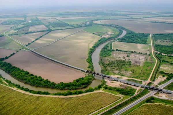
The soundscapes of El Tren Fantasma (the title is identical to that of a 1927 Mexican movie) offer a trip from the Pacific Coast to the Gulf Coast of Mexico condensed into little more than an hour.

The first six tracks cover the section of railway best known as the Copper Canyon line, one of the few remaining routes in Mexico with regular passenger service.

El Tren Fantasma has 10 tracks (pun intended):

  1. La Anunciante
  2. Los Mochis
  3. Sierra Tarahumara
  4. El Divisadero
  5. Crucero La Joya
  6. Chihuahua
  7. Aguascalientes
  8. Mexico D.F.
  9. El Tajin; El dia y La noche
  10. Veracruz

If you don’t have time to listen to all 10 tracks, the most interesting, from a geographical point of view, are probably the following:

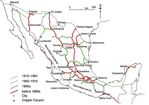
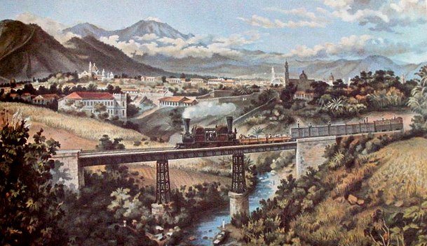
The trip was nicknamed the ghost train by Watson because there are no longer any passenger trains connecting the two coasts. Several years ago, Watson was the sound recordist for a film crew making a program in the BBC TV series Great Railway Journeys. Even then, part of the line was freight only, but in earlier times, there had been regular scheduled passenger trains across the country.

The promotional material asks potential listeners to, “Take the ghost train from Los Mochis to Veracruz and travel cross country, coast to coast, Pacific to Atlantic. Ride the rhythm of the rails on board the Ferrocarriles Nacionales de México (FNM) and the music of a journey that has now passed into history.”

“In this album, the journey of the ‘ghost train’ is recreated, evoking memories of a recent past, capturing the atmosphere, rhythms and sounds of human life, wildlife and the journey itself along the tracks of one of Mexico’s greatest engineering projects.”

Reviews were almost universally positive.

Several reviewers recognized the connection between the soundscapes of El Tren Fantasma and geography, in some cases also attributing reasons for the decline of passenger train services in Mexico. For example Martin Hoyle, writing in The Financial Times, described how “From desert to rainforest, hummingbirds’ wings to the boom of heat rising from the Copper Canyon, it recalls a beloved passenger train system abandoned by privatisation.”

Pete Naughton in The Daily Telegraph wrote that the sound portrait painted by Watson “jostles with human, animal and mechanical life, filling the room with an atmosphere that is more richly evocative of Central America than any TV travel show I’ve seen. Diesel engines thrum, cicadas chirrup and passengers chatter, sing and argue.”

A reviewer in The Milk Factory (UK) drew attention to the “tremor of excitement as the sound of a diesel engine temporarily swallows the clunking noise of metal on metal and the strident hisses as wheels grind again rails and breaks against wheels”, before adding that, “Watson doesn’t aim to recreate the journey in any consistent chronology. Instead, he gives a taste of what this journey actually was by using nature and wildlife sounds to hint at the landscapes passed on the way.”

Spencer Grady, reviewing El Tren Fantasma for BBCi (UK), wrote that: “While Chris Watson’s previous sets – such as 2003’s critically acclaimed Weather Report – have generally concerned themselves with this planet’s myriad beasts and habitats, this narrative inevitably bears an anthropological mark. Indeed, the first voice we hear doesn’t belong to a cuckoo or coyote, but station announcer Ana Gonzalez Bello putting out one “last call for the ghost train”. It’s an unusually contrived opening gambit, from which point the listener is jettisoned into a collision of screeching breaks, rolling stock rattle and hot hydraulic huff. Over half of El Tren Fantasma’s tracks (pun definitely intended) are given over to locomotive sound – gears shifting, hoots, bells and whistles – climaxing with El Divisadero, where Watson manipulates the monolithic machinations into a surging, phantasmal bellow, like a choir of angels struggling to be heard over the rumbling thrum of running gear.”

For an academic geographer’s perspective on El Tren Fantasma, a good place to start (for those with academic library access) is a recent issue of Transactions of the Institute of British Geographers (Vol 39, No 3, 2014). In “El tren fantasma : arcs of sound and the acoustic spaces of landscapes”, George Revill, of the Open University, draws on Chris Watson’s soundwork “El tren fantasma” to consider “how sound participates in the production of the railway corridor as a complex, animate and deeply contoured historically and geographically specific experience of landscape.”

El Tren Fantasma offers an extraordinarily evocative sound summary of a trip across Mexico; what a shame that there are now so few passenger services left on Mexican railways!

Related posts:

Aug 112014
 

Earlier this year, a slew of press reports discussed the possibility of a Mexico-USA high speed rail link from the industrial powerhouse of Monterrey in Nuevo León state to San Antonio in Texas. (For one example, see Fast train to Monterrey on the horizon).

The reports say that Mexican transport officials and their U.S. counterparts believe that this international high speed rail link could be in operation within a decade. The new line would move passengers between the two cities in about two hours, saving almost three hours compared to highway travel.

Route of proposed high speed train from Monterrey to San Antonio. Credit: Daily Mail.

Route of proposed high speed train from Monterrey to San Antonio. Credit: Daily Mail.

A key part of the plan would be a system to pre-clear U.S. Customs which sometimes delays northbound motorists at border crossings for several hours. (Such a pre-clearance system would be analogous to that already operating in several Canadian airports, where U.S.-bound passengers clear U.S. immigration and customs prior to boarding their flights).

Mexican officials have already secured the rights of way for the rail line from Monterrey to the U.S. border and say that this section of the line, likely to cost around 1.5 billion dollars, could be up and running as early as 2018. The U.S. section, from the border northwards, is unlikely to be completed before 2022 at the earliest, though a $5.6 million study of potential high-speed rail lines stretching from Laredo to Oklahoma City is already underway.

The first high speed rail links in North America are likely to be in Mexico, where planning is well advanced and the first construction contracts are being awarded for building high speed links from Mexico City to Toluca and Querétaro. Plans for a high speed train in the Yucatán Peninsula have also been announced.

For more details of the Mexico City-Toluca high speed rail project, see Plans to improve the Mexico City-Toluca transport corridor.

Want to read more?

Plans to improve the Mexico City-Toluca transport corridor

 Mexico's geography in the Press  Comments Off on Plans to improve the Mexico City-Toluca transport corridor
Jan 202014
 

The Mexico City Metropolitan Area (dark grey on the map), which occupies the Valley of Mexico, extends well beyond the northern boundary of the Federal District and includes many municipalities in the State of Mexico. The two administrations (the Federal District and the State of Mexico) have to work closely together in order to coordinate actions in the Metropolitan Area, which had a population in 2010 of 20.1 million.

Map of Mexico City urban system

Map of Mexico City urban system. Click to enlarge. (Geo-Mexico Fig. 23.1; all rights reserved)

Toluca, the capital of the State of México, is Mexico’s 4th largest urban area, and a fast-growing industrial city in its own right, with a 2010 population of 1.8 million.

Toluca’s airport (the “Licenciado Adolfo López Mateos International Airport”) is mainly used by low-cost carriers like Interjet, Volaris and Aeroméxico Connect as an alternative to using the Mexico City International Airport, which is more expensive and operating at close to capacity. Passenger traffic through Toluca airport has grown rapidly, from 145,000 passengers in 2002 to a peak of almost 4 million in 2008, before falling back to about 1 million passengers in 2012.

Not surprisingly, the Mexico City-Toluca highway is one of Mexico’s busiest major routes, linking the Federal District via Toluca (see map) to western Mexico.

In recent months, several related plans have been announced that are designed to improve the two major transportation issues in this area:

  1. The near saturation of Mexico City International Airport
  2. The very busy (and often slow) highway between Mexico City and Toluca

To ease the situation of Mexico City International Airport, the federal Communications and Transportation Secretariat (SCT) plans to expand the airport eastwards, onto 5,500 hectares of federal land. The expansion is likely to take several years to complete, and will increase flight capacity even though it will not include an additional terminal.

Meanwhile, State of Mexico authorities have authorized a second runway for the Toluca International Airport, which will significantly expand that airport’s capacity. The SCT has proposed that Toluca Airport become an alternate airport for Mexico City, with the two airports linked by high-speed trains.

The SCT has already announced that a new rail link between Toluca and Mexico City will be jointly financed by the federal government and the State of Mexico. The existing plan is for the first phase of the “Toluca-Valley of Mexico Interurban Passenger Train” to end at the Metro Observatorio station in Mexico City, but a later phase would extend this line to Mexico City Airport. This new 2.7-billion-dollar rail line, capable of carrying 300,000 passengers a day, will run from Toluca via the upscale Mexico City neighborhood of Santa Fe to Metro Observatorio, reducing the travel time between Toluca and Metro Observatorio by more than an hour to around 40 minutes, with corresponding positive environmental impacts. Construction of the new line, which will include 4 intermediate stations, is due to begin later this year, and scheduled to be completed by 2018.

A separate 115-million-dollar project is underway to reduce highway congestion between Toluca and Mexico City. To boost the road transport capacity between the two cities, a multi-lane second tier is being added to 15 kilometers of the existing Mexico City-Toluca highway, from La Marquesa to Paseo Tollocan, at the entrance to Toluca.

Related posts:

Mexico’s Copper Canyon train is one of the world’s great railway trips

 Excerpts from Geo-Mexico, Other  Comments Off on Mexico’s Copper Canyon train is one of the world’s great railway trips
Sep 022010
 

The Copper Canyon region is one of the most remote parts of Mexico. This remoteness helps to explain why the area is the home of about 50,000 Tarahumara Indians, and how they have managed to preserve much of their highly distinctive culture to this day.

The Copper Canyon railroad line, “the most dramatic train ride in the Western Hemisphere” (Reader’s Digest), begins in Ojinaga and continues, via Chihuahua, to Los Mochis and Topolobampo. The railroad was started in the 1870s to enable produce grown in southern Texas to be exported via a Pacific port. Simultaneously, the twin settlements of Los Mochis and its port Topolobampo were developed on the other side of the Western Sierra Madre. The railroad project floundered and successive attempts to complete it all failed. Some innovative engineering finally led to the line being completed in 1961. Total cost? Over $100 million.

The highlights include a 360-degree loop at El Lazo (km 585 from Ojinaga), one of only three comparable examples anywhere in North America), and a 180-degree turn inside a tunnel near Temoris at km 708. The line crosses the Continental Divide three times, reaches a maximum height of 2400 m (at km 583) and skirts the rim of the Copper Canyon. Between Chihuahua and Los Mochis, there are 37 bridges (totaling 3.6 km) and 86 tunnels (totaling 17.2 km). Almost all passenger rail services in Mexico ended in the 1990s but daily services continue along this line, mainly for tourists.

Tarahumara Indians wait for a sale at Divisadero, the station on the rim

Tarahumara Indians wait for a sale at Divisadero, the station on the canyon rim. Photo: Tony Burton; all rights reserved.

Almost all trains stop for a few minutes at Divisadero, a station set right on the rim of the canyon, with a lookout offering a magnificent panoramic view. Shy Tarahumara women and children sit quietly, weaving pine-needle baskets (see photo) and hoping for a sale. Many of them speak very little Spanish apart from the numbers; on the other hand, how many tourists speak even one word of the Tarahumara language? Thirty years ago, most articles sold by the women were items similar to ones they would use everyday themselves in their daily tasks. Sadly, many of the articles sold today are made specifically for the tourist trade.

Unlike the railway, Los Mochis and Topolobampo both soon flourished. Topolobampo was started by US engineer Albert Kimsey Owen who chose this previously unsettled area for a socialist colony based on sugar-cane production, and as the terminus for the railway. Topolobampo has one of Mexico’s finest natural harbors, a drowned river valley or ria, which affords a safe haven in the event of storms. Los Mochis was officially founded in 1893 by a second American, Benjamin Johnston, who built a sugar factory there.

Los Mochis became especially important in the second half of the twentieth century as a major commercial center, marketing much of the produce grown on the vast El Fuerte irrigation scheme. Much of this produce is still exported to the USA via the famous Copper Canyon railway. Los Mochis and Topolobampo are unusual—there are few other examples of such “new towns”, with no colonial or pre-Hispanic antecedents, anywhere else in Mexico.

Previous Geo-Mexico posts related to the Copper Canyon:

External links of interest:

Chapter 10 of Geo-Mexico: the geography and dynamics of modern Mexico is devoted to Mexico’s indigenous peoples, including the Tarahumara Indians. If you have enjoyed this post, please suggest to your local library that they purchase a copy to enhance their collection.

Jun 282010
 

About 1900 one of the densest railroad networks on earth was operating in the Yucatán Peninsula. Between 1870 and 1920 the area experienced an economic boom based on the production of twine from sisal (oro verde or green gold). The numerous plantations in the area needed a way to move the sisal from the fields to processing centers and from there to ports for export. The plantation owners built a very extensive (4500 km) system of narrow gauge railroad system to move sisal as well as sugar and corn.

Map of Yucatan's railways

Map of Yucatan's railways. Copyright Allen Morrison. Reproduced by kind permission (see link to original map near end of this post). Click map for larger version.

The tracks stretched up to 100 km in all directions from Yucatán’s capital, Mérida. Rolling stock and complete sections of track with steel ties were imported mostly from Europe but also from the USA. The small trains were powered by mules, steam engines, electric batteries, and later by gasoline motors. There was no standard design. Several different gauges were in use ranging from 400 to 930 mm (15.7 to 36.6 in).

Foreign competition, the Mexican Revolution, and synthetic fibers brought an end to the sisal boom. Many of the plantations closed in 1930s. Soon small entrepreneurs were providing rail passenger services between the scores of towns in the area. Many families used the small sisal hauling cars as personal transport, powered by a horse or mule. This was far more efficient than animal drawn carts on the rough dirt roads, but required occasional de-railing to allow those going in the opposite direction to pass. Some of the Yucatán’s narrow gauge lines have survived into the 21st century, and some of the former sisal haciendas have reopened as luxury hotels for tourists.

Acknowledgments: Grateful thanks to Allen Morrison, who generously allowed us permission to reproduce his excellent map of Yucatán railways.

Mexico’s transportation systems are the subject of chapter 17 of Geo-Mexico: the geography and dynamics of modern Mexico. Buy your copy today!

Yucatán’s main line railway was not linked to the rest of Mexico until about 1950.

Mar 102010
 

As mentioned in a previous post about tourist guidebooks, the introduction of railways into Mexico and the gradual expansion of the railway network encouraged the development of all kinds of social, industrial and tourist activities.

The Mexico City-Puebla line was completed in 1886 and went via the small town of Cuautla in the state of Morelos. Cuautla is about 25 kilometers south-east of Cuernavaca.

In Cuautla, the builders of the railway found a perfect location for the town’s new station, very close to the center. They station was constructed around the cloisters of an abandoned building, the former Dominican convent of San Diego, which dated back to 1657. Its ecclesiastical life ended some years before parts of it were incorporated into the railway station in 1881.

The 1899 edition of Reau Campbell’s famous Guide provides an idea of what visitors to Cuautla could expect when the train was in its heyday:

The train stops some minutes in Cuautla and there may be time for a walk through the little alameda, just outside of the station, where there are trees and flowers, a hotel where there are good wines, coffee and lunches to be had. As the approach to the station has been through a grove of tropical trees and gardens, so is its departure, and the train continues southward through the cane country to Yautepec…

A decade later, the British-born journalist William English Carson (1870-1940) spent four months in Mexico. Carson also visited Cuautla:

It is a quaint, old-fashioned place, with narrow, cobble-paved streets, and houses of the usual low, flat-roofed type. As I strolled about the town the next morning, I noticed some unusually amusing signs of Americanization. An enterprising barber, for example, displayed a big signboard with the English inscription, “Hygienic, non-cutting barber shop,” as a tempting inducement to tourists, and one or two other establishments displayed in their windows the interesting announcement, “American spoke here.”

The Oldest Railway Station in the World. Cuautla. Inter-Oceanic Railway (from Carson).

Carson also describes the railway station:

Cuautla is also famous for having the oldest railway station in the world, the crumbling, ancient structure which is now used for this purpose having been the Church of San Diego built in 1657. … The day after my arrival I went into the old church, the body of which is now used as a warehouse, while one side of it bordering the railway line provides accommodation for the waiting-room and various offices. A quantity of wine-barrels were piled up at the spot where the high altar had formerly stood, and all kinds of merchandise were stored in other parts of the building. Over the door was an inscription, the first words of which seem appropriate enough to the present condition of the once sacred edifice: “Terribilis est iste hic domus dei et porta coeli ” (How dreadful is this place. This is none other but the house of God and this is the gate of heaven).

In October 1973, the original narrow gauge track from Mexico City to Cuautla was replaced with standard gauge line, bringing a premature end to the lives of several steam engines. These engines were among the very last steam locomotives used in regular service anywhere in North America. Fortunately, the oldest section of narrow gauge in Mexico, built between Amecameca and Cuautla still survives. Originally built in 1881 as the Ferrocarril Morelos (Morelos Railroad), it was partially re-opened, between Cuautla and Yecapiztla, for a tourist steam train service in July 1986, using engine #279 and four restored second class coaches. Engine 279 is a Baldwin locomotive, built in Philadelphia, first brought into service in 1904, and now spends most of its time resting contentedly in the Cuautla museum, the museum that is housed in the oldest building ever used as a railway station anywhere in the world.

Postscript: The rival claims of Red Hall, Bourne, U.K. to be the oldest station building in the world

I am very grateful to Tony Smedley and Ian Jolly, two very alert railway enthusiasts from the U.K., for bringing to my attention the rival claims of a railway station building in Lincolnshire to be the oldest in the world. The original owner of Red Hall, in Bourne, died in 1633. The Hall was later used as the Station Master’s house and Ticket office for the Bourne & Essendine Railway, which began operations in 1860. The last passenger train through Bourne station was apparently in 1959, with freight services ending a few years later. (For more details, click on Red Hall and Bourne Railway Station respectively.

Since the Red Hall (Bourne) station no longer has any rail tracks or trains associated with it, I stand by my claim (for now at least) that Cuautla station (which still does have rail tracks and trains) is the oldest railway station in the world. Apparently, Carson, at the time he was writing, was unaware of the rival claims of Red Hall.

Sources:

Campbell, Reau. Campbell’s New Revised Complete Guide and Descriptive Book of Mexico. Chicago. 1899.

Carson, William English. Mexico: the wonderland of the south. 1909

This is an edited version of an article originally published on MexConnect.
Click here for the complete article

The growth of the railway network and the importance of railways in Mexico are examined in depth in chapter 17 of Geo-Mexico: the geography and dynamics of modern Mexico and tourism in Mexico is the subject of chapter 19.

The development of railways led to tourist guide books

 Other  Comments Off on The development of railways led to tourist guide books
Mar 012010
 

In the golden age of steam, railway lines were built all over Mexico. Rail quickly became THE way to travel. Depending on your status and wealth, you could travel third class, second class or first class. Anyone desiring greater comfort and privacy could add their luxury carriage to a regular train. To avoid mixing with the ordinary folk, the super-rich and the privileged few hired or ran their own special trains.

The railway era ushered in an entire new genre of travel writing, which culminated in the first genuine guidebooks, describing routes and places that other travelers could visit with relative ease. The earliest comprehensive guide to Mexico was Appletons’ Guide to Mexico (1883); it was soon followed by several others including Campbell’s Complete guide and descriptive book of Mexico, first published in 1895.

The 1899 edition of Reau Campbell’s famous Guide provides an idea of what visitors to Cuautla in the state of Morelos, for example, could expect when the train was in its heyday:

Here again the tourist finds another feature of Mexico’s scenery and people, totally different from all the other travels in the Republic. The houses are adobe as to walls and thatched as to roofs; the broad plains have curious trees; bands of Indians troop from one town to another in curious costumes, marching along totally oblivious to the passing locomotive and approaching civilization, and will not give way to the latter any quicker than they will to the engine if they happen to be on the track when it comes along. In fact, it is hard for them to understand that the train cannot “keep to the right” when it meets people in the road, and they claim the right of way from the fact that they were there first.

A decade later, the British-born journalist William English Carson (1870-1940) spent four months in Mexico. Carson also visited Cuautla, on the advice of a doctor as the result of catching influenza.

Upon making inquiries at the railway office about trains to Cuautla, the clerk handed me an illustrated pamphlet with a fine colored picture on the cover representing a Mexican tropical scene. It bore the title, “Cuautla, Mexico’s Carlsbad.” What! I thought, another Carlsbad? In glowing language the booklet described Cuautla as an earthly paradise with a magnificent climate, beautiful scenery, splendidly equipped hotels and a warm sulphur spring whose waters were a certain specific for almost every human ailment. What more could one desire?

Carson continues:

Cuautla is about a hundred miles or so from Puebla, and the speedy trains of the Interoceanic Railway take about ten hours to make the journey. The train which I took left about seven o’clock in the morning ; it was not timed to reach Cuautla until five in the evening; and as there was not any restaurant at any intermediate station, a somewhat terrifying prospect of starvation faced travellers. How were they to get their luncheon? A little pamphlet given away by an American tourist agency and evidently written by an accomplished press-agent gave me the desired information: “At a certain station on the road,” said my traveller’s guide, “your train will stop for some twenty minutes. Here you will be greeted by graceful Indian women,— beauties, many of them, with their olive skins and dark, flashing eyes, bearing themselves with queenly grace in their dainty rebosos and flowing garments, white as the driven snow. They will offer you such dainties as tamales, chili-con-carne and tortillas, piping hot from their little stoves, and prepared with all the scrupulous cleanliness of a Parisian chef. They will bring you dainty refrescos of freshly gathered pineapple or orange to quench your thirst, and pastry such as your mother may have made when her cooking was at its prime.”
Now, what more could any reasonable traveller demand? What need was there for a restaurant when there were all these good things to be enjoyed? I showed my guide to an American friend before I started. He chuckled, gave a knowing wink and remarked, “Great is the faith of man, for after all your experiences you can still believe in a Mexican guide-book.”

Hotels were not always the same standard as those in the USA, but were certainly less expensive:

The attractions of the hotel were hardly up to those of a Carlsbad establishment, for it had neither a writing nor a smoking room; but the terms were rather more attractive than the usual Carlsbad tariff, being about two dollars a day inclusive. It is true there was a good deal of Mexican about the cooking, but the meals were not at all bad and the service very fair…

Railways may have opened up Mexico for tourism, but today, sadly, there are virtually no passenger lines still operating, the main exception being the justly famous Copper Canyon line from Los Mochis to Chihuahua.

Sources:
Campbell, Reau. Campbell’s New Revised Complete Guide and Descriptive Book of Mexico. Chicago. 1899.
Carson, William English. Mexico: the wonderland of the south. 1909

This is an edited version of an article originally published on MexConnect.
Click here for the complete article

The growth of the railway network and the importance of railways in Mexico are examined in depth in chapter 17, and tourism in Mexico is the subject of chapter 19. of  Geo-Mexico: the geography and dynamics of modern Mexico.