Mar 132014
 

Having noted in previous posts that farm sizes in southern Mexico are smaller (on average) than in northern Mexico, and that farm size is affected by socio-economic factors, and that farmers of smallholdings are unable to generate a decent profit, it is interesting to consider the relationship between farm size and marginalization.

Mexico’s National Population Commission (Conapo) has formulated a compound indicator of “marginalization” and publishes its “marginalization index” at regular intervals. Data are available at both the state and the municipal level for the entire country. This discussion relies on the state level data.

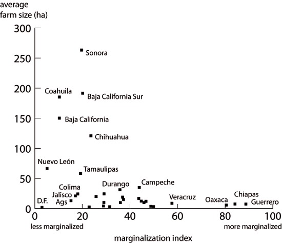
Scatter graph showing average farm size and marginalization index

Scatter graph showing average farm size and marginalization index. Data: INEGI, Conapo. Credit: Geo-Mexico

Each dot on this scatter plot represents a state. For the 32 points, the statistical correlation (Spearman’s Rank Correlation Coefficient) is –0.483. This negative correlation (significant at the 95% level) means that marginalization is inversely associated with farm size  (i.e. the greater the marginalization, the smaller the likely farm size).

In short, the north-south divide that we found when looking at the pattern of farm sizes in Mexico is closely linked to the north-south economic divide that characterizes the country.

Related posts:

Geo-Mexico has many other agriculture-related posts (easily found via our tag system). They include posts about the geography of growing/producing Christmas trees, cacao, honey, sugarcane, coffee, chiles, floriculture, tomatoes, tequila, horticultural crops and oranges. Also worth reading are:

The number of small farms in Mexico is growing

 Excerpts from Geo-Mexico, Updates to Geo-Mexico  Comments Off on The number of small farms in Mexico is growing
Mar 032014
 

The uneven distribution of farmland in Mexico was one of the fundamental causes of the Mexican Revolution in 1910, but by no means the only one. Landless campesinos (peasant farmers) lacked any way to control their own supplies of food. Revolutionary leaders called for the expropriation of the large estates or haciendas, which had been the principal means of agricultural production since colonial times, and the redistribution of land among the rural poor. A law governing this radical change in the land tenure system came into force in 1917 and the process has continued, albeit sporadically, into modern times.

About half of all cultivated land in Mexico was converted from large estates into ejidos, a form of collective farming. In most ejidos, each individual ejidatario has the rights to use between 4 and 20 hectares (10-50 acres) of land, depending on soil quality and whether or not it is irrigated. In addition, members of the ejido share collective rights over the use of local pasture and woodland.

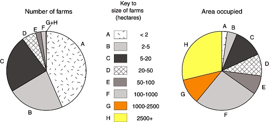
By 1970 land redistribution had been more or less completed. Even so, most farming land still remained in the hands of a very small minority of farmers (Figure 15.2). Only 1% of farms were larger than 5000 hectares (12,355 acres) but between them they shared 47% of all farm land. Meanwhile, 66% of farms were smaller than 10 hectares (25 acres) yet they shared only 2% of all farm land.

Have things improved since then?

The 2007 farm census (see graphic) revealed that two-thirds (66.4%) of all farms are under 5 hectares (12.4 acres) in area; this percentage has remained roughly the same over the past 40 years. Between them, they farm just 6.2% of Mexico’s total farmland.

The number and size of farms, 2007

The number and size of farms, 2007 (updated Figure 15.2 of Geo-Mexico). Data: INEGI. Credit: Tony Burton / Geo-Mexico

The number of small farms has increased since 1970, but so has the total number of farms. Between 1991 and 2007, there was a 55.2% increase in the number of farms under 2 hectares in area, and a 45.4% increase in the total area they worked.

There is no solid data for why the number of microfarms has increased, but it may be partially explained by larger farms being split into smaller pieces (one for each family member) following the death of their original owner.

Most tiny farms are likely to be family-run, producing crops largely for subsistence, rather than for market. Small plots of land are likely to prove uneconomic and unsustainable to farm; it is impossible to generate sufficient profit from them for a family to enjoy a decent livelihood.

In one study, Enrique de la Madrid Cordero, writing for Financiera Rural, calculated that a typical smallholding of 5 hectares, planted with corn (maize) could generate a profit for the owner of about $4000 pesos. This profit represents 6 months work. At the time of his study, someone earning minimum wage for the same six months would have received a total of almost $10,000 pesos. The precise numbers vary, depending on average yields and the crops planted, but cultivating a smallholding is obviously not an easy way to make a living.

These same farmers are unable to advance since they have no means of accessing credit, having no suitable assets to offer as collateral, even if they could ever afford to pay the interest! Similarly, they do not have the savings to invest in improved equipment, higher cost seeds or to introduce new techniques or technology. They are, essentially, trapped in a cycle of poverty.

At the other end of the scale, a very small percentage of farms in Mexico are very large indeed. Nationwide, 2.2% of farms account for 65.1% of the total area farmed in the country. Larger farms are commercial operations, sometimes multinational operations. Their size and profitability ensures they have ready access to credit, and can adopt new technologies and methods relatively quickly.

The uneven distribution of land in Mexico clearly remains an issue, one that is likely to impact social justice agricultural output and productivity for decades to come.

Related posts:

Geo-Mexico has many other agriculture-related posts (easily found via our tag system). They include posts about the geography of growing/producing Christmas trees, cacao, honey, sugarcane, coffee, chiles, floriculture, tomatoes, tequila, horticultural crops and oranges. Also worth reading are:

Are Aztec chinampas a good model for food production and agro-development?

 Other  Comments Off on Are Aztec chinampas a good model for food production and agro-development?
Oct 072013
 

There is no doubt that Mexico’s indigenous farmers developed numerous ways to ensure successful harvests. The details varied from one region to another, but among the techniques employed were:

  • the mitigation of erosion by building earth banks and check dams in gullies
  • polyculture, recognizing that this minimized the risks inherent in monoculture.
  • the terracing of steep slopes to channel water where it was most needed.

In addition, some indigenous groups, including the Aztec in central Mexico, took advantage of their expertise in water management to develop highly productive systems of farming in wetlands. The chinampas (or so-called ‘floating gardens’) in the Valley of Mexico are the prime example of this water management skill, though similar systems were also used in the coastal marshes along the Gulf coast.

On the other hand, the later introduction of large-scale commercial farming methods has often led to deleterious impacts on the countryside and the long term sustainability of such methods is questionable.

In seeking to help Mexico’s rural areas, some development experts have suggested re-adopting Aztec methods, especially their method of building chinampas to farm wetlands. The invention of chinampas as a highly productive form of intensive wetland cultivation was, historically, one of the greatest ever agricultural advances in the Americas. Among other things, it allowed settlements to thrive in areas where rain (and therefore rain-fed food production) was markedly seasonal.

Among attempts to re-introduce ancient methods, one which stands out occurred in the 1970s and 1980s, when INIREB (Instituto Nacional de Investigaciones sobre Recursos Bióticos), based in Xalapa (Veracruz) employed chinamperos from the Valley of Mexico to build experimental chinampa-like fields in Veracruz and Tabasco . These projects are briefly described in Andrew Sluyter’s fascinating book Colonialism and Landscape, Postcolonial theory and applications (Rowman and Littlefield, 2002), the main basis for this summary.

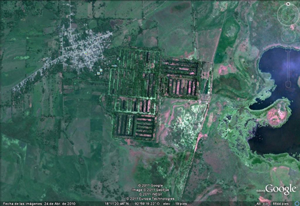
Google Earth image of camellones chontales

Google Earth image of camellones chontales

The most ambitious project was a later federally-organized one in Tabasco, where 65 massive platforms (camellones), each about 30 meters wide and from 100 to 300 meters long, were built in the swampy Chontalpa wetlands. The project, known as camellones chontales was backed by the local Chontal community though it was not directly involved in the construction phase. Because of the scale of the project, large mechanical dredgers were used to build the platforms, rather than relying on laborious and slower hand labor.

After construction, the Chontal community began farming the platforms, but initial results were very disappointing. Things improved with time, especially when the Chontal took full control of the project. From their perspective, the project meant that more members of the community now had land that could be farmed, and they shifted the emphasis away from the “vegetable market production” favored by officials towards growing corn (maize), beans and bananas for local household consumption, improving local food availability.

Recent press reports, such as this 2-minute Youtube clip (Spanish), claim that many parts of the camellones chantales have now been abandoned, owing to insufficient investment in maintenance.

Why did the project fail initially?

This is one of the key questions connected to this example. Sluyter refers to two articles written by Mac Chapin (from Cultural Survival, an organization that champions the rights of native peoples). Chapin argues that the projects, and their assumptions, were fundamentally flawed. For example, the use of dredges to construct the platforms turned the soil profile upside down, bringing infertile clay towards the top and sending nutrient-rich layers downwards, beneath the reach of plant roots. In turn, this meant that organic matter and fertilizers had to be added to the land in order for good crop yields. Because of the dredging, the canal floor between the platforms was very irregular, making it much more difficult for the Chontal to fish using drag nets. Many of the crops planted were “exotic” and production was market-oriented rather than subsistence or locally-oriented. Chapin was particularly critical of the lack of suitable transport routes for sending produce to distant markets. In addition, chemicals were needed because of the proliferation of insects in these lowland wetlands. (Insects are rarely a problem at the higher altitudes of central Mexico).

Chapin concluded that this development project was just one more in a long line of failures where an outside model was introduced into a new area without sufficient prior research or local involvement in the planning stages. Sluyter agrees with this conclusion, pointing out that there is no evidence that these Tabasco wetlands ever had any form of chinampa farming, even in pre-Columbian times, perhaps because they have “a much greater annual fluctuation in water level than those in Campeche and Veracruz”.

Want to read more?

Related posts:

Angahuan, the nearest village to Paricutín Volcano in Michoacán, Mexico

 Other  Comments Off on Angahuan, the nearest village to Paricutín Volcano in Michoacán, Mexico
Mar 142013
 

Last month we recounted the events surrounding the birth of Paricutín Volcano in 1943 in the state of Michoacán in western Mexico:

Angahuan, the nearest village to Paricutín Volcano, is fascinating in its own right, quite apart from its connections to the volcano. The village has a lovely mid-sixteenth century church with many Moorish characteristics, as well as peculiar and distinctive house styles which make widespread use of local timber.

The original name was Andanhuan, which the Indians say the Spanish couldn’t manage to pronounce, hence its transformation to Angahuan. The Purépecha name meant “place on high where people stopped” or “place where the person on high (captain) stopped”.

The Spanish, complete with captain, arrived in 1527, under the command of Nuño Beltrán de Guzmán. One of the first missionaries here, Jacobo Daciano, ordered a Moorish stonemason who was with him, to stay in Angahuan and build a convent. The mason did a fine job—the church ceiling is truly magnificent—and Angahuan church is one of the very few in the country with such marked Moorish influences. The church is dedicated to Santiago (Saint James) and, as elsewhere in Mexico, he is shown astride his horse.

Across the small plaza is a wooden door richly carved in a series of panels which depict the story, or at least one version of it, of the eruption of Paricutín. Judging by one panel, the indigenous Purépecha artist-carpenter responsible for the door, Simón Lázaro Jiménez, clearly had a sense of humor about tourism. His design won first prize in a regional handicraft competition in 1981. The artist rejected the prize, copyrighted his unusual design, and used the finished handiwork as his own front door. He later penned a short book, Paricutín, 50 years after its birth, a vivid first-hand account of the fateful day when the volcano erupted and changed the lives of the local people for ever.

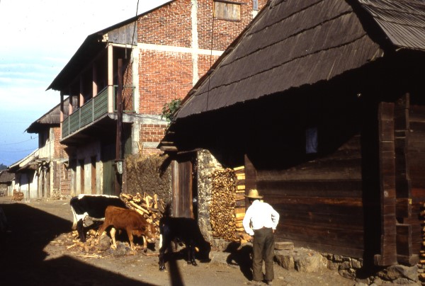
House types in Angahuan: traditional and modern. Photo: Tony Burton; all rights reserved

House types in Angahuan: traditional and modern. Photo: Tony Burton; all rights reserved

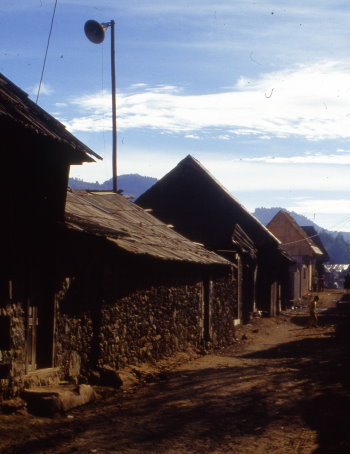
The distinctive house-types of Angahuan called trojes, are built of wooden beams with steep roofs. They are slowly giving way to modern monstrosities built with concrete blocks. The roofs of the traditional houses have either two or four slopes. Those with two slopes, one each side of the house, are called techos a dos aguas (literally “two waters”, “saddle roof” in English), those with four slopes techos a cuatro aguas (“four waters” or “hip roof”).

Angahuan: loudspeakers like this one relay village news.

Angahuan: loudspeakers like this one relay village news. Photo: Tony Burton; all rights reserved

Many small Mexican towns and villages rely on a village loudspeaker system for relaying all important events and news. Angahuan is no exception; look for the speakers mounted high over the plaza. Local announcements are in Purépecha, the local Indian language totally unintelligible to Spanish speakers. This is the only common language for the Indians in this area, since many of the older people do not speak Spanish. When necessary, their children will often translate for them. The Purépecha language is not closely linked to any other native Mexican language, but is apparently distantly related to that spoken by the Zuni of the USA and the Quechua and Aymara of South America.

Angahuan is one of the most accessible Purépecha villages in Mexico and well worth visiting, especially if your interests lie more in indigenous ways of life than in the splendid scenery and interesting geology of its surroundings.

This post is a lightly edited extract from my “Western Mexico: A Traveler’s Treasury” (Sombrero Books, 2013). “Western Mexico: A Traveler’s Treasury” is also available as either a Kindle edition or Kobo ebook.

Related posts:

Aug 162012
 

Six months ago, we gave an optimistic mention of Maya Biosana, a cacao megaproject in Quintana Roo, noting that it had received the support of the federal Agriculture Secretariat (Sagarpa):

We also noted that the project was not without its critics. In this post, we look at some of the claims, counterclaims and available evidence.

What is Maya Biosana?

The Maya Biosana project aims to make Mexico the leading producer of organic cacao in the Americas. In the early phases, Maya Biosana claims it will plant one million cacao trees to create 500 hectares (1200 acres) of irrigated orchards in 12 communities near Chetumal in Quintana Roo, with similar numbers of new trees to be planted annually for another three years. The trees are expected to yield 2.4 metric tons of cacao per hectare, produce 4800 metric tons of cacao a year (destined for high quality chocolates) by 2017 and provide up to 2,000 additional jobs.

A fuller description of the intended project (pdf file, in Spanish) is available on the Sagarpa website.

Pipedream or reality?

Industry insiders, such as Denver-based chocolate maker Steve DeVries, who leads specialist tours to the cacao growing regions of Mexico, Costa Rica and Ecuador, have drawn our attention to the fact that such numbers will be virtually impossible to achieve. In their view, producing and planting one million cacao plants will take far longer than a year, even in ideal circumstances. They also point out that a million trees on 500 hectares would be an average planting density of 2000 plants/hectare. According to the Food and Agriculture Organization (FAO), about half that figure, 1025 plants/hectare, would be a more normal spacing.

The Maya Biosana project apparently intends to plant only cacao Criollo. Of the three main varieties of cacao (see further reading for more details) – Forastero, Criollo and Trinitario –  Criollo produces the most flavorful chocolate, but is little used at present in the mainstream chocolate industry because it is very susceptible to disease, and takes longer to reach maturity. The most widely grown variety is Forastero, which is hardy but least flavorful, while Trinitario, a hybrid of the first two, falls somewhere in the middle.

This makes Criollo a very strange choice for such a major plantation. In fact, industry insiders say, there is no source anywhere in Mexico for the huge quantity of Criollo grafts that the Maya Biosana project would require.

Maya Biosana claims that the first phase of its megaproject is already underway on land in the Los Divorciados ejido, about 100 km from Chetumal, and recently released a promotional video. The film includes lots of “feel good” footage and memorable quotes, but some of the footage of mature cacao appears to have been shot elsewhere, presumably in Tabasco state. More importantly, what exactly does the Maya Biosana team bring to the table, besides good intentions?

Who are the main players in Maya Biosana?

The two main players in Maya BioSana, according to press reports, are Jim Walsh and Fernando Manzanilla.

Entrepreneur Jim Walsh is the self-styled “reinventor of chocolate”, CEO of Hawaiian Vintage Chocolate from 1992, and CEO of the closely-related Intentional Chocolate since 2007. Fernando Manzanilla Prieto is a well-connected Mexican politician, member of Partido Acción Nacional (PAN), and businessman who is currently the Secretary General of the government of the state of Puebla in central Mexico.

According to its website, samples of Intentional Chocolate, co-founded by Walsh and Manzanilla, were given by former president Bill Clinton as a gift to the Japanese Royal family and have the seal of approval of the Dalai Lama. The company “treats” regular chocolate using “breakthrough licensed technology” that “helps embed the focused good intentions of experienced meditators and then infuses those intentions into chocolate”. An early press release stated that such chocolate can “significantly decrease stress, increase calmness, and lessen fatigue in those who consume it”.

The major claim made for this chocolate is that it elevates the mood of consumers more than non-intentioned chocolate does. This claim is based, apparently in its entirety, on a single “double-blind, randomized, placebo-controlled experiment”, the results of which were published in an article, co-authored by Walsh, entitled Effects of Intentionally Enhanced Chocolate on Mood in EXPLORE: The Journal of Science & Healing, an Elsevier journal, in the September/October issue of 2007 (Vol 3, No 5: 485-492).

The sample size was small, 62 individuals in total. For one week, participants self-recorded their mood by means of a recognized “profile of mood states”. Some participants consumed “intentioned” chocolate, and others “non-intentioned” chocolate, twice a day, at the same times, for three consecutive days, in the middle of the week.

The most fascinating part of the article is actually the last paragraph, where the authors recommend that efforts to replicate the findings should “seriously consider sources of intentional enhancement and contamination that might influence the postulated effect.” They call for intentional imprints to be provided only by “highly experienced meditators or other practitioners”, writing that “persons holding explicitly negative expectations should not be allowed to participate for the same reason that dirty test tubes are not allowed in biology experiments.” Even more bizarrely, they claim that vigilance about the intentions of people involved in the test may even extend to “people who learn about the experiment in the future after the study is completed”.

Put another way, skeptics and disbelievers should stay home.

To the best of our knowledge, the Explore study has not been replicated, while statisticians and others have criticized the methods used and the conclusions drawn. See, for example, Debunked: Effects of Intentionally Enhanced Chocolate on Mood.

The other two authors of the Explore study besides Walsh are Dean Radin and Gail Hayssen. Radin is a prolific author of articles about parapsychology and also just happens to be a co-editor of Explore. Both Radin and Hayssen hold posts at the Institute of Noetic Sciences in Petaluma, California.

Walsh and Radin, together with Manzanilla, all have connections to the Human Energy Systems Alliance (HESA) Institute,  “an alliance of scientists, philosophers, entrepreneurs, and spiritual leaders devoted to unlocking the potential of the human energy system and to developing technologies and products that transform human health and increase human flourishing.”

According to the HESA Institute’s list of its main members (webpage no longer active) , Walsh is the institute’s founder and CEO, and Radin is a prominent member. Manzanilla’s bio claims that he was, too, founded HESA but, curiously, his name is absent from the HESA Institute list.

Between them, Walsh and Manzanilla have created an impressive web of interlinked and overlapping projects, supported by an equally dazzling range of positions on advisory boards. For example, both men are members of the three-person advisory board of the Institute for Spirituality and Wellness (ISW) at the Chicago Theological Seminary (CTS), which continues “to educate and prepare future leaders for a multitude of ministries” (Ref). The CTS is an affiliated seminary of the United Church of Christ, “a mainline Protestant Christian denomination primarily in the Reformed tradition but also historically influenced by Lutheranism” (Ref).

Several of the projects associated with Manzanilla, according to his CTS bio, have surprisingly little or no web presence. For example, he founded (in 2007 according to his Linkedin profile) and remains CEO of ImaginaMéxico, which “directs a network of organizations whose brands encompass the areas of food and beverages, agro forestry and wellness, human capital and technology, all under the common theme of helping individuals lead more meaningful and vital lives.” Yet, as of last week, the ImaginaMéxico website was “under construction”. According to the bio, Manzanilla also founded Cielo y Tierra (no web links found), Facthum-Mexico (no website found) and Kakaw Universal (no evidence from a Google search that it even exists)…. Manzanilla also co-founded Baja BioSana,  “an intentional community with a vision to become an example of sustainable living and educational center” (Ref) located in the small village of El Choro in Baja Califórnia Sur.

Financial shenanigans

It now looks as if the Maya Biosana project may be dead in the water, before it ever really gets off the ground. According to this document from the Superior Audit Office of Mexico (Auditoría Superior de la Federación), Maya BioSana received two payments in 2010 from Financiera Rural, acting on behalf of Sagarpa, as part of the latter’s  Strategic Project for Sustainable Rural Development in the South-South-East Region of Mexico (Proyecto Estratégico para el Desarrollo Rural Sustentable de la Región Sur Sureste de México). The two payments totaled 15 million pesos (about $1,140,000 dollars).  The document states that Sagarpa is already requesting the return of these funds because the Maya Biosana project has fallen behind schedule.

The Superior Audit Office document says that visits to the site did not find any cacao plantation and alleges that the Sagarpa funds had been transferred from one company account to another before a payment for 12,400 million pesos (about $946,000 dollars) was made to a foreign bank account belonging to one of the individuals who had signed on behalf of the company “Maya Biosana S.A.P.I de C.V.” Perhaps this was the cost of the recently-released video?

For the sake of the ejidatorios of Los Divorciados in Quintana Roo, who were counting on the success of the Maya BioSana cacao-growing megaproject, we hope that they have gained, and will gain, more from this experience than they lost. They deserve far better than a mere handful of chocolate-coated intentions.

This is one chocolate megaproject that appears to be melting fast. Maya BioSana looks much more like Maya Bio-Insana.

Further reading:

  • Cacao domestication I: the origin of the cacao cultivated by the Mayas
  • Cacao domestication II: progenitor germplasm of the Trinitario cacao cultivar

Related posts:
Do paved roads lead to development?

 Excerpts from Geo-Mexico, Updates to Geo-Mexico  Comments Off on Do paved roads lead to development?
Jan 042012
 

In chapter 24 of Geo-Mexico, we described a typology of rural settlement locations and wrote that “rural localities near roads” (defined as those settlements within 3 km (2 mi) of a paved road) are an important category since they house 54% of all Mexico’s rural population. In fact, such settlements account for almost 90% of rural population in Quintana Roo and over 70% of the rural population in the states of Zacatecas, Yucatán, Campeche, San Luis Potosí, Nuevo León and Coahuila.

We explained that while “One of us believes that the location of paved roads is having an impact on rural settlement patterns, the other believes that rural settlement patterns are having an impact on the location of paved roads! Both viewpoints may be correct with their relative importance depending on the region in question.”

Shortly after the publication of Geo-Mexico, a loyal reader (“Jerezano“) wrote to us, agreeing with us, and sharing his personal insights into “rural localities near roads” based on his 23+ years living in the beautiful, small town of Jerez, in the state of Zacatecas. He writes,

“You are both correct, of course.”

“The rural settlement was in most cases located where it was long before the roads were paved. A municipality (municipio), when it decides to pave a road, considers many things:

  • a) Where does the money come from? Local residents, associations of residents in foreign countries who send money back for improvements? and municipal and federal matching funds?
  • b) Existing population figures which of course influence the traffic on the roads.
  • c) Economic contribution of that rural community to the welfare of the state and municipality.”

“So, a rural community with a fairly large population, a robust economy, and an active out-of-town group of supporters, will get a paved access road long before a different community which lacks those attributes. That is easily observable in almost any location.”

“But, once that access road has been paved, the influence is also usually observable by the improved economy of that community. Easy access of products to markets, easy access of potential new residents to the city, etc. will stimulate increases in costs of real estate, living, etc.”

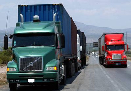
“Here in Zacatecas, for example, the paving of the road to Susticacán from the Jerez-Guadalajara highway stimulated a building boom which is still in progress. The construction of the new 4- lane divided highway from Zacatecas City to Concepción de Oro, and now underway from Concepción de Oro to the Coahuila border, has created an extremely active trailer stop at the Villa de Cos intersection. Before the new highway was started, that intersection was a place with potential and people who had constructed facilities such as restaurants, hotels and a gasoline station were waiting with baited breath.”

Mexican trucks“They are now reaping the benefits of the movement of many, many tractor-trailers from the Ramos Arizpe to San Luis Potosí highway and on to Mexico over to the new Ramos Arizpe to Zacatecas to Mexico highway. At the Villa de Cos intersection where, in the past, you would see pickups, quarter ton, 3/4 ton and a maximum of 4 to 10 ton trucks, you can now see as many as 10 to 20 semi-trailers and doble-remolques (double drop trailers) parked in front of the main restaurant and hotel. All this because the road has been steadily improved over the years from a narrow, two lane Federal highway, with a bad surface most of the distance, to the modern 4 lane divided highway easily transited by rigs which (God forbid) are really too big to be on the highways.”

We sincerely thank Jerezano for taking the time to share these valuable personal insights into rural roads in his “neck of the woods” in Zacatecas, and hope that the New Year brings him and all our readers Health, Happiness and Prosperity.

Oct 222011
 

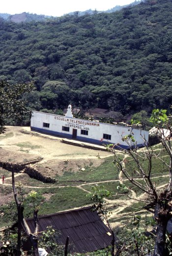
Mexico’s pioneering “telesecundaria” or “television secondary school” system began back in 1968. It now provides junior high school classes in remote areas, serving about one million students in grades 7 to 9, 17% of the total nationwide enrollment in these grades. Many of the telesecundaria lessons are now available on the Internet, and before long, about 4,500 classes will also be available on a DVD collection.

The geographical network of telesecundarias is truly amazing. In the early 1980s, I came across one high in the mountains in a distant corner of the state of Hidalgo, in a remote Huastec village, beyond even Coca Cola’s delivery routes. A visitor was such a surprise that the entire village turned out to inspect me!

Telesecundaria in Ixcatepec, Hidalgo

Telesecundaria in Ixcatepec, Hidalgo (1983) Photo: Tony Burton

It was that experience that made me realize that Mexicans take education very very seriously. The telesecundaria was perched on the hillside overlooking the village. I later discovered this was a fairly typical example, with three classrooms, rustic restrooms in an outhouse, and a small playground. Most telesecundarias also have a science laboratory and a small library.

The students in a telesecundaria do have a teacher, but this teacher teaches every subject, whereas in a regular junior high, each student will have up to twelve different subject specialists. Every telesecundaria classroom has a television set to receive lessons broadcast by the Education Ministry (SEP) in Mexico City.

Professional Programs

In the early days, lessons were very traditional, and the TV programs were little more than continuous shots of a “talking teacher”. Interestingly, almost all those early lessons were broadcast live. Nowadays, the entire process is much slicker and far more professional. The TV programs are 15 minutes long and feature all kinds of material, including animated graphics and video footage. Watching them, you are unlikely to see the “talking teacher” even for an instant! It takes about 20 days to produce each 15-minute module and costs up to 50,000 dollars. Most programs have a useful life of between five and ten years, depending on the timing of significant changes in subject content and teaching methods.

After students have seen the TV broadcast, the classroom teacher then uses the remaining 45 minutes of each hour to explain the lesson in more detail and to monitor students as they complete related tasks from their special telesecundaria textbooks.

Nationwide satellite transmission of programs began in 1994 (EDUSAT), enabling the coverage to spread far beyond those areas previously served by conventional TV stations. Programs are broadcast daily.

On-line samples

With the advent of the Internet, the telesecundarias are now being revamped as one part of SEP’s “On-line educational TV” (“Televisión educativa en línea“) project. That page has links to currently playing segments of material for various levels, including telesecundaria, and for teachers. (This is also a valuable resource for non-native speakers working to improve their Spanish and/or their knowledge of Mexico.)

Telesecundarias have proved to be an extraordinarily effective way of improving access to, and standards of, junior high education across Mexico. While the “costs of delivery” are estimated to be 16% higher in telesecundarias, on a per student basis, than in regular junior high schools, they are significantly cheaper on a per school basis. This means that some of the nation’s 13,000 or so telesecundarias can function cost-effectively even with only 10 or 12 students in each grade level.

The success of telesecundarias

Are telesecundarias successful? It certainly seems so. An estimated 79.4% of telesecundaria students complete grade 9, compared with an equivalent figure of 78.8% for regular junior highs. In addition, one study has shown that telesecundaria students may start Grade 7 significantly behind other students but generally catch up completely in math and reduce the deficit in language.

The program has been adopted by most Central American countries—Costa Rica, El Salvador, Guatemala, Honduras and Panama—and pilot projects are underway in the USA in California, Colorado, Pennsylvania, Oregon and Florida.

So next time you’re traveling in the wilds of Mexico or Central America, play “I spy” and see how many telesecundarias you can find. Bonus marks should be awarded for any that are outside the normal delivery range of Coca-Cola or Sabritas!

The hierarchy of central places in Mexico

 Excerpts from Geo-Mexico  Comments Off on The hierarchy of central places in Mexico
Jul 132011
 

How well does central place theory fit the Mexican situation? In terms of the relative numbers of settlements of different size, it fits quite well. The theory suggests that there will be a regular (geometric) progression between the number of settlements of each successive size. The hierarchy of central places in Mexico is quite similar to that predicted by the theory (see table).

Population sizeNumber of localities or municipalities% of national population
< 2,500184,71423.5
2,500–9,9992,37910.6
10,000–49,99961512.1
50,000–499,99916225.6
500,000–999,9992313.9
1,000,000 +1114.3

At the lowest level in Mexico are a large number of very small centers providing a limited range of goods and services. At this level are small convenience stores (abarrotes or bodegas) selling basic Mexican household goods such as sugar, tortillas, bread, produce, snacks, basic canned goods, candy, eggs, beer, soft drinks, cigarettes, matches and basic toiletries.

Other small stores at this lowest level might sell such things as household cooking and lighting fuels (wood, gas, or kerosene), seed, animal feed, fertilizer and other basic farm inputs. Other services might include a place that buys agricultural production, auto and tire repair shops, and a bus pick-up point. Some of these small centers might also have tortillerías (shops making tortillas), a primary school and a pay phone.

At the next higher level there is enough demand to support everything at the lowest level plus simple bakeries, hardware stores, mini-super markets, electrician/plumbers, welding shops, simple clothiers or dressmakers, beauty salons, basic health care, simple pharmacies, a church, a secondary school, simple eateries, and repair of household electrical items (radios, blenders, TVs). There might be only half or a third as many settlements (places) at this level as at the lowest level.

Central places at this level might also have weekly or periodic markets. Such markets usually occur only one day a week because there is not sufficient threshold demand to support them on a daily basis.

The link is to a map showing the major weekly marketing cycles for the Oaxaca area in southern Mexico. With the exception of Oaxaca city (population 480,000) and Miahuatlán (33,000), all the other towns have populations between 13,000 and 20,000. The merchants at such markets generally carry their wares from village to village on the days of their respective markets. Some local farmers also sell their produce at such markets. These markets give villagers access to a much wider range of goods than might otherwise be possible. Simultaneously, traders maximize their opportunities to make a profit.

Depending on the rural population density and economic demand for particular goods and services in the geographic area, periodic or weekly markets may not exist at this level of the hierarchy in some regions and may only appear at higher levels.

A similar principle applies to a circus (figure 24.4 in Geo-Mexico), which needs access to an even larger threshold population than a weekly market. This is because each individual visitor will not be prepared to travel far to see the show and has little interest in seeing the same acts more than once. Even a very large city will only house enough people to fill the Big Top for a few weeks. The circus’s solution, in central place terms, is to access the combined populations of numerous towns or cities by moving from one to the next, on an annual or biannual itinerary.

As we move up the hierarchy in Mexico, there is enough demand to support everything at the lower levels as well as new services requiring higher levels of threshold demand. These might include doctors, dentists, carpenters, construction supplies, furniture and cabinet makers, bars, restaurants, a Pemex gas station, auto parts stores, and a variety of retail outlets selling such things as stationary and paper products, mobile phones, toys, flowers, plastic ware, and kitchen items. Centers at this level are larger and far fewer in number than the smaller centers at lower levels.

At the next higher level there are even fewer and even larger central places providing such services as appliance sales, jewelry stores, banks, opticians, lawyers, accountants, photographers, preparatory schools, hospitals, hotels, used car and pickup sales, a Coca-Cola bottler, funeral homes, a bus station, a Telmex office, TV and electronics sales, cyber cafes, clothing boutiques and shoe stores.

Further up Mexico’s hierarchy there is enough demand to support higher level services such as: new car and truck sales, TV and radio stations, movie theaters, giant supermarkets, printers, bookstores, dry cleaning, real estate offices and office supply stores. Centers at this level would be fewer in number and have larger geographic market areas.

At the top of the hierarchy are places like Mexico City and Guadalajara, where the demand is sufficient to support the highest level goods and services such as giant modern retail malls, international airlines, convention centers, international hotels, live theater, investment banking, TV studios, multimedia advertising agencies, major universities with medical schools, all types of specialized luxury products, and very specialized professional services such as heart and brain surgeons.

Related posts:


Central place theory and rural access to central place services

 Excerpts from Geo-Mexico  Comments Off on Central place theory and rural access to central place services
Jul 092011
 

A previous post – The four basic types of rural locality in Mexico – indicates that access to sources of goods, services, markets and opportunities is very important to the economic and social well-being of rural and farm communities. Such sources are called central places and may be a village, a small town, a large town or a city.

Farms in rural areas may still grow some of their own food, but they are far less self-sufficient than they were a century or two ago. In Mexico, farm families are definitely part of the cash economy and buy more of their household needs than they produce on the farm. Items purchased from central places include such goods as sugar, clothing, hardware, farm tools, kitchen utensils, fertilizer, pesticides, hybrid seed, oil or kerosene for lamps, matches, paper products, as well as medicines, soft drinks, beer and cigarettes. Rural areas are also dependent on outside services provided by schools, buses, doctors, dentists, beauticians, mechanics and churches. To pay for these goods and services they are also dependent on markets where they can sell their farm products or their labor to obtain the cash they need to make necessary purchases.

Central place theory

Considerable academic attention has been focused on central places which provide goods and services to their market areas or hinterlands. Walter Christaller analyzed the German rural economy in the 1930s and developed central place theory. The theory provides an idealized description of how goods and services are supplied in rural areas throughout the world. Central place theory describes the spacing and hierarchy of central places by focusing on the threshold demand needed to support specific goods and services, the market areas of central places, and the distances rural people travel to obtain specific goods and services.

According to the theory, every rural region is served by a hierarchy of central places. At the bottom of the hierarchy there are a large number of very small places providing services with very low threshold demands. These very small centers serve the population in the center and a small surrounding rural area.

As one moves up the hierarchy, there are a fewer number of places, providing a wider range of goods and services, and serving a larger market area. This occurs because for a service to be provided efficiently there must be sufficient threshold demand in the center and its surrounding hinterland to support it. For this reason we do not find new car dealers, heart surgeons or ballet schools in every small village. These activities can only survive in large centers where there is sufficient demand.

Rural residents must travel varying distances to centers to obtain needed goods or services. The center may be small or may be large depending on the specific good or service that is needed. Rural residents might have to travel less than a few kilometers to a center at the bottom of the hierarchy to buy basic food stables or to attend primary school. They generally have to travel farther to a higher level center to get more specialized items such as clothing, health services, or secondary schooling. They generally have to travel considerably farther to buy a pickup truck, board an airplane or obtain the services of a heart specialist.

Related posts:


The four basic types of rural locality in Mexico

 Excerpts from Geo-Mexico  Comments Off on The four basic types of rural locality in Mexico
Jul 062011
 

In a previous post, we looked at why Some rural areas are more rural than others.This post describes each of the four distinct categories of rural areas identified by Mexico’s National Population Council (CONAPO).

Rural localities near cities

This group is defined as localities within five kilometers (3 mi) of cities of at least 15,000 inhabitants. It accounts for 16% of Mexico’s rural population, about four million people. About half of the rural populations of Morelos and Tlaxcala fall into this group.

Some communities in this category are actually part of the suburbanization or urban sprawl process. People have ready access to many city services and opportunities. If they lack mechanical transportation, they can walk to the city in less than an hour.

What are the socioeconomic characteristics of these localities? The data needed to answer this question often are not readily available. Fortunately, CONAPO has classified rural localities in terms of their degree of marginalization, which provides insights into socioeconomic characteristics. Degree of marginalization is defined using indicators of adult educational attainment, housing quality, and income levels.

About 47% of rural, near city residents live in very marginalized localities.3 While this is much higher than it is in urban areas, it is significantly less than other rural areas. Rural areas near cities tend to be more similar to urban areas. By way of comparison, in Mexico as a whole about 19% of the population live in municipalities classified as very marginalized.

Representative characteristics of very marginalized communities include adult populations with illiteracy rates of about 25% and completion of primary school rates of only 56%. Roughly 27% of houses lack piped water, 27% lack indoor toilets, 46% have dirt floors and 64% are overcrowded. These housing indicators are closely correlated with significant health risks. About 15% of houses do not have electricity. Roughly 84% of economically active people make less than twice the minimum wage. Communities matching this description are very different from modern urban Mexico.

At the other end of the spectrum, only about 4% of near city residents live in non-marginalized localities, which we will call “modern”.5 For Mexico as a whole, 53% of the population live in modern municipalities. The figure is 100% for the 33 million people who live in Mexico’s nine urban areas of over one million inhabitants. Levels of marginalization will be discussed more fully in chapter 29.

Rural localities near towns

This category includes localities within three kilometers of towns with between 2,500 and 15,000 residents. About 2.4 million people, or 10% of the rural population, live in such communities. These localities account for about a quarter of the rural population of Morelos and the State of Mexico.

Communities in this category are more rural than communities near cities. They have easy access to goods and opportunities in towns, but lack ready access to a real urban area. About 66% of this group lives in very marginalized communities compared to 47% for the near cities group. Less than 1% of the near towns group live in modern communities.

Rural localities near roads

This large group includes localities within three kilometers (2 mi) of paved roads. Almost 13 million Mexicans, about 54% of the rural population, fall into this category. It accounts for almost 90% of the rural population in Quintana Roo and over 70% in Zacatecas, Yucatán, Campeche, San Luis Potosí, Nuevo León and Coahuila.

This is a relatively important category because almost 14% of Mexico’s total population lives in rural communities near roads. These localities account for 39% of the total population of Zacatecas, and about a third of the total for Hidalgo, Oaxaca and San Luis Potosí. The authors agree to differ as to the reasons for this. One of us believes that the location of paved roads is having an impact on rural settlement patterns. The other believes that rural settlement patterns are having an impact on the location of paved roads! Both viewpoints may be correct with their relative importance depending on the region in question.

While people living in these localities do not have walking access to a city or town, they can relatively easily get to a town or city by bus. Some 69% live in very marginalized communities, while less than 1% live in modern communities. In terms of marginalization, the near roads group is quite similar to the near towns group.

Isolated rural localities

This group includes rural localities that do not fit into any of the other three categories. They are the most rural in that they lack ready access to paved roads, towns or cities. These inaccessible areas are very rarely seen by outsiders. Most urban residents have limited understanding of life in these isolated areas. Communities in this group are among Mexico’s poorest. About 88% of the people in isolated rural localities live in communities classified as very marginalized; less than 1% live in modern communities.

Though data are not available, areas that are within 10 km of a city, town or paved road are likely to be less marginalized than those in more remote locations. Almost five million Mexicans, about 20% of the rural population, live in these communities. Over a million people in Chiapas and about half a million in Oaxaca and Puebla live in isolated localities. The figure for Chiapas represents 29% of the state’s total population. About 16% of the people in Nayarit and Oaxaca and 12% of those in Sinaloa and Guerrero live in isolated areas. Providing needed basic services to these rural Mexicans is a major challenge for these state governments as well as the federal government.

Related posts:

Some rural areas are more rural then others

 Excerpts from Geo-Mexico, Teaching ideas  Comments Off on Some rural areas are more rural then others
Jul 022011
 

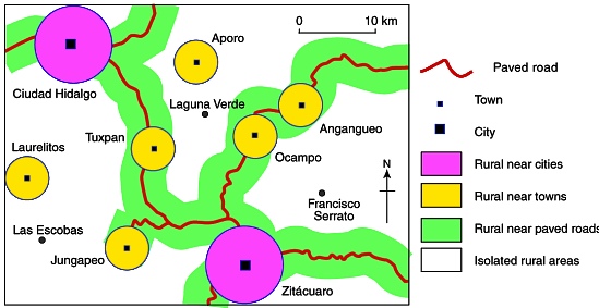
We all recognize that some cities are more urban than others. For example, Mexico City is considered more urban that a town of 20,000. By the same token, some rural communities are more “rural” than others. For example, a small settlement located near a city or along a main road would be considered less rural than an equally sized settlement in a more isolated area.

CONAPO's categories of rural area applied to eastern Michoacán

CONAPO's categories of rural area applied to eastern Michoacán. Credit: Tony Burton; all rights reserved.

The National Population Council (CONAPO) classifies rural localities into four groups based on accessibility to cities, towns and roads. The map shows how these four groups relate to a region in the eastern part of Michoacán state.

Suggested classroom exercise:

Appendix B of Geo-Mexico gives the percentages for each of these four rural groups in each state. What would be the best way to map the figures for the percentages of rural groups in each state?

Are Mexico’s rural areas more diverse than its cities?

 Excerpts from Geo-Mexico  Comments Off on Are Mexico’s rural areas more diverse than its cities?
Jun 302011
 

Which are more diverse: Mexico’s rural areas, or its cities?

At first glance, Mexico’s rural areas are all quite similar in that they lack the characteristics of Mexico’s large cities such as tall buildings, traffic congestion, modern shopping malls, bustling streets, heavy industry and the like. While rural areas are all similar in that they lack urban characteristics, Mexico’s rural areas are actually quite diverse. But is there really more diversity among Mexico’s rural communities than its cities?

The physical form and architecture of cities are essentially independent from their surrounding natural environments. On the other hand, rural settlements tend to be integrated more closely with the natural environment. For example, villages in the arid central plateau tend to be constructed of locally available adobe, which keeps residents relatively cool during the hot afternoons and warm during the colder nights. In the tropical parts of Mexico, rural settlements tend to be built with locally available tropical materials which keep the rain out, but let air breezes through to mediate the hot tropical climate.

Rural settlements all tend to rely heavily on farming as the basic economic activity. The surrounding natural environment essentially dictates the type of farming that is practiced. Obviously, farmers in the central plateau cannot successfully grow bananas, sugarcane and other tropical products requiring lots of water. However, varieties of corn are grown virtually everywhere in Mexico.

The social characteristics of Mexico’s rural areas are also very diverse compared to the cities. In general Mexican cities are quite similar from a social perspective. Social customs and mores, as well as social classes, are relatively constant from one city to the next. Spanish is the overwhelmingly dominant language in the cities. Rural communities in various parts of the country often have different social mores and customs. Communication in some rural areas is largely, if not almost exclusively, in local indigenous languages:

The diversity of Mexico’s almost 200,000 rural localities should not be confused with the relative homogeneity within any given rural community.

In conclusion, while diversity between rural areas may be greater than that between cities, there is usually far more diversity within a Mexican city than within any given rural community.

Access to services is worst in the smallest rural localities of Mexico

 Updates to Geo-Mexico  Comments Off on Access to services is worst in the smallest rural localities of Mexico
May 102011
 

Access to services such as schools, public transport or the internet are better in cities than in rural areas (localities in Mexico with fewer than 2,500 inhabitants). However some rural areas have far better access than others. Perhaps not surprisingly, the number of inhabitants of a rural locality is directly related to its access to services.

The 2010 census indicates that 26.0 million Mexicans (about 23.2% of the population) live in rural areas. A total of 9.0 million live in Mexico’s 5,921 large rural communities (those with 1000–2499 inhabitants) compared to 11.3 million living in the 22,852 mid-sized rural localities (250–999 people) and 5.7 million in the 159,820 small rural settlements (fewer than 250 residents). The average population in the last group is only 36 inhabitants indicating that many Mexicans live in very tiny communities.

The percentage of communities with access to a health center or clinic is 74.9% for the large rural areas, 50.7% for the mid-sized, and only 37.9% for the small rural areas. The percentages for access to either a secondary school or telesecundaria (Mexico’s satellite-fed secondary schools, see Geo-Mexico, page 126) also differ with the size of the community: 79.6%, 51.5% and 27.0%, respectively. Though these percentages are far lower than those for larger, urban communities, they have improved very significantly. The census indicates that rural areas are catching up with the rest of Mexico, especially with respect to education, life expectancy and fertility, three very important, inter-related variables.

In turn, this suggests that government programs such as Oportunidades are achieving something positive in some areas beyond poverty reduction.

The network of roads providing access to rural villages has improved significantly. 81.2% of the smallest localities now are connected by road, compared to 96.7% for the mid-sized and 98.3% for the large rural areas. However, these data indicate that almost 31,000 rural Mexican communities are still not accessible by road. Only 63.5% of the small rural villages are served by public transport, compared to 74.6% of the mid-sixed and 89.3% of the large rural localities. A total of almost 107,000 rural communities do not have any public transport and are consequently quite isolated. This isolation is a very serious constraint to their economic opportunities and quality of life. The people who live in communities without access to a paved road are among Mexico’s poorest; fully 88% are classified as “very marginalized” (see Geo-Mexico, page 184).

Internet access is only beginning to penetrate into rural areas. Only 3% of the smallest rural villages have public access to the internet (via school, cybercafé, etc.). About four times as many (11%) of mid-sized rural localities have public internet access. Almost half (45.6%) of the large rural communities have public internet access compared to 74.3% of larger communities between 2500 and 4999 inhabitants. Current trends suggest that by 2020, virtually all Mexicans will have some type of internet access, perhaps by cell phone.

Fertility decline not as fast as expected, but faster in some areas of Mexico than others

 Updates to Geo-Mexico  Comments Off on Fertility decline not as fast as expected, but faster in some areas of Mexico than others
May 092011
 

Data from the 2010 census indicate that the fertility rate did not decline as fast in the last decade as previously expected. On the other hand, the actual reduction was significant and consistent with Mexico’s demographic transition which will lead it to zero natural population growth by mid-century. See our 15 May 2010 post: Mexico’s demographic transition and flirtation with overpopulation.

At mid-decade Mexico’s National Population Council (CONAPO) projected that the total fertility rate would decline to an average of 2.1 children per women for the 2010 census. The new census data indicate that the fertility rate for 2009 was actually 2.4 compared to 2.9 in 1999. This decline is still significant but not quite as rapid as previously expected.

Fertility rates vary greatly for different areas of the country. Like many other socio-economic variables, fertility is closely related to community size. It declines systematically with increasing community size. Rural areas (localities of less than 2,500 population) had the highest rate of 2.9 in 2009, equal to the national level in 1999. If this ten year lag relationship continues, we might expect the fertility rate in rural areas in 2019 to be equal to the 2009 national rate of 2.4. The fertility rate in rural areas declined the fastest in the past decade, a full 24% from their 3.8 rate in 1999.

Towns between 2,500 and 15,000 dropped 16% from 3.1 to 2.6. Small cities between 15,000 and 100,000 declined by 14% from 2.8 to 2.4, the national average. For cities of over 100,000 the 2009 rate was 2.1 (the theoretical replacement level), compared to 2.4 in 1999.

The Federal District has the lowest fertility rate by far, for example women between age 35 and 40 have had an average of 1.8 children compared to the national average of 2.5. Using this measure, other states with low fertility levels include Nuevo León with 2.3, followed by Baja California Sur, Colima, State of Mexico, Morelos, Quintana Roo and Yucatán with 2.4. The highest fertility rates are in Chiapas and Guerrero where women between age 35 and 40 have had 3.2 children on average, followed by Oaxaca with 2.9.

The demographic transition model and its application to Mexico is described in depth in chapter nine of “Geo-Mexico; the geography and dynamics of modern Mexico”.

Apr 302011
 

The quality of housing in Mexico has improved significantly in the past two decades. By the 2010 census, 97.8% of Mexican households had access to electricity, compared to 95.0% in 2000 and 87.5% in 1990. That this figure is approaching 100% is a real accomplishment given that many Mexicans live in very isolated mountainous communities. As of mid-2010, 93.5% of rural households had electricity, compared 98.2% for towns between 2,500 and 15,000 and over 99% for larger towns and cities. Anyone who has lived without electricity knows what an incredible improvement it can make to one’s comfort and quality of life.

With smaller family sizes, household crowding has also declined. It went from 5.0 persons per household in 1990 to 4.4 in 2000 and 3.9 in 2010. The percentage of households with dirt floors is now down to 6.2%, compared to 13.2% in 2000 and 19.5% in 1990. In rural areas, 15.1% of houses have dirt floors compared to 7.7% in towns between 2,500 and 15,000.

The vast majority of rural houses now have piped water. In the 125 least developed municipalities in rural Mexico, over 63% of households have piped water, which is one of the most important factors for improved family health. Almost 39% of the households in these poor municipalities have sewers, a convenience that most rural residents now have. However, about half of all rural households still cook with firewood or charcoal.

Rural households are gaining increasing access to modern electrical conveniences. Almost 80% now have a television set, 62% have a refrigerator, 42% have a washing machine, and 36% have a cell phone (only 17 % have a wired telephone line). While these percentages are significantly higher in urban areas (TVs – 97.5%, refrigerators – 91.7%, washing machines – 78.4%, and cell phones – 78.4%.), life in rural Mexico is improving dramatically. However, rural areas are lagging significantly in access to the cyber-age. Only 6.8% have a computer in the house and 2.5% have internet access. Urban access is much higher: 42.7% for home computers and 33.1% for internet access. On the other hand, many rural households gain access to computers and the internet by using cyber-cafes, which have spread rapidly into small Mexican communities.

Local "bus" to the train station, Tehuantepec, 1985

Local "taxi" to the train station, Tehuantepec, Oaxaca, 1985. Photo: Tony Burton; all rights reserved

Access to public transportation has also improved in rural areas (see photo, taken in 1985). In mid-2010, 73% of rural residents had access to public transportation (usually bus or taxi). Access varies with community size. Of those in communities of 1,000 to 2,500, almost 90% have access, while only 37% of those localities of under 250 population had access to public transportation.


Mexico’s cities and towns are analyzed in chapters 21, 22 and 23 of Geo-Mexico: the geography and dynamics of modern Mexico. Rural Mexico is the subject of chapter 24. Living standards, including housing, are discussed in chapter 28. Buy your copy today!!

Highway improvement revolutionized the economy of Chilapa, Guerrero

 Excerpts from Geo-Mexico  Comments Off on Highway improvement revolutionized the economy of Chilapa, Guerrero
Aug 112010
 

Transportation improvements can have profound impacts on the areas they serve.  A major highway improvement in the 1970s revolutionized the rural economy of Chilapa, a small town about 40 km east of Chilpancingo, the capital of Guerrero.  Prior to 1970, the area was essentially self-sufficient, as it had been for hundreds of years.  All the corn and most of food consumed in Chilapa came via pack animals from farms within 12 km of the town.  It did produce some cotton shawls (rebozos) and later woven palm goods which were sold to obtain money for salt, iron, cotton, matches and other essentials not produced locally.

In the 1970s, the old narrow windy road to Chilpancingo was upgraded to a national highway (No. 92), straightened and paved, dramatically reducing transport time and costs.  This had a dramatic impact on Chilapa.  Corn and other goods from the rest of Mexico and abroad poured into the area, leading to significantly lower prices. The local farmers could not compete; many stopped farming altogether.  Some started commuting by bus to low paying jobs in Chilpancingo.  When subsidies became available for chemical fertilizers and hybrid corn, farmers began producing high quality corn that was sold outside the area. Chilapa continued importing cheap, low quality corn for local consumption. The new road completely changed the economy of the area around Chilapa, brought it farther into the national economy and improved its standard of living. There are thousands of communities in Mexico that are not yet served by paved roads and are essentially as self-sufficient and poor as Chilapa was before the 1970s.  In addition, there are hundreds of other communities not reached even by dirt roads; they are even poorer and more self-sufficient.

Note: the main source for material about Chilapa is Kyle, C. 1997 “Transport and Communication” 1910-96, in Werner, M.S. (ed) Encyclopedia of Mexico: History, Society & Culture. Chicago, Fitzroy Dearborn.

The development of transportation systems in Mexico is the focus of chapter 17 of Geo-Mexico: the geography and dynamics of modern Mexico.


A small village in Mexico won a 2004 UN Development Prize

 Excerpts from Geo-Mexico  Comments Off on A small village in Mexico won a 2004 UN Development Prize
Jun 142010
 

Every two years, the United Nations Development Programme (UNDP) awards the Equator prize (worth 30,000 dollars) to communities that have shown “outstanding achievement in the reduction of poverty through the conservation and sustainable use of biodiversity.”

One of the winners of the 2004 Equator prize was the indigenous community of Nuevo San Juan Parangaricutiro, in the state of Michoacán. More than 340 communities, from 65 countries, were nominated for consideration by the Equator Prize jury. The seven winning communities were honored at a prize-giving ceremony held in conjunction with an international Biological Diversity Conference in Kuala Lumpur, in Malaysia.

The success of Nuevo San Juan Parangaricutiro (hereafter referred to simply as Nuevo SJP) is all the more remarkable since their community did not even exist prior to 1944.

That is the year when all the founding residents of Nuevo (New) SJP fled their homes in “viejo” (Old) SJP as the sizeable town was overwhelmed by the lava erupting from Paricutín volcano. Paricutín first erupted, completely unexpectedly, in the middle of a farmer’s field, on February 20, 1943. It is a sobering thought that only 61 years to the day before the prize-giving, the volcano literally did not exist.

A remarkable account of those early days is given by Simón Lázaro Jiménez, who recounts in his book, Paricutín: 50 Years After Its Birth, his adventures as a young boy as he fled with his parents for safety as their small village of Angahuan was bombarded with red-hot rocks and ash. Don Simón’s is the only first-hand account of any substance written by a native P’urépecha speaker.

The volcano finally stopped erupting in 1952, but only after completely destroying the village of Parícutin (note that the position of the accent has changed over the years) and the town of viejo SJP. All that is left of the latter today are a few broken-down walls and parts of the huge, old church that did a brave job of withstanding the compelling force of the lava as it overran the rest of the town.

The people who fled the volcano (many initially refused to leave, but were escorted to safety by armed soldiers) stayed with friends and relatives and in makeshift camps before finding permanent accommodation, but later in 1944, founded Nuevo SJP after a presidential decree gave them land formerly belonging to the hacienda of Los Conejos.

The new town had to be completely planned from scratch. A gigantic church was built to commemorate the miraculous survival of part of the Old San Juan church which formed a partial barrier to the lava flow. Little by little a new community evolved, fostered in part by the high degree of cooperation required for building a new town and working virgin land.

In 1977, motivated by the abuse of local forest lands by private concession holders, the campesinos of Nuevo SJP organized their own union for farming and forestry workers. In 1981, they began their own forestry industry, and now collectively own and manage more than 11,000 hectares of pine, oak and fir forest. Over the years, their business activities have diversified to include a saw mill, a furniture factory (which has won export orders from Belgium and Ireland), a plant making wooden moldings for export to the USA, avocado and peach orchards, a packing plant which makes its own cases, a Christmas tree plantation, eco-tourism cabins and a resin distillation plant, as well as a store for the bulk purchase and resale of fertilizers. A water bottling plant, to bottle spring water, is one of the community’s latest proposals.

The community’s website gives details of all these activities and includes a link to a furniture catalog for those interested in buying direct. All the wood used is certified as “Smart Wood” (coming from well-managed forests) by the Forest Stewardship Council.

Community decisions in Nuevo SJP are made on behalf of the 8,000 or so residents by a General Assembly of the 1,300 Comuneros (community representatives), which has met at least once a month since 1983.

The Equator Prize was awarded because the forest policies adopted by the community “have provided a boost to local incomes while ensuring that the resource base upon which the community depends is sustained for future generations.” In addition, “the community’s successes have spread well beyond their origins as these novel conservation and business practices have been widely adopted by other indigenous communities in Mexico.”

Nuevo SJP may not be very old, or very large, but it certainly has a really big heart!

For a more detailed account of the history of the volcano, and of the considerable architectural attractions of the village of Angahuan, including its superb church, read chapter 35 of Western Mexico: A Traveler’s Treasury (Sombrero Books 2013).

Original article, as published on MexConnect

Mexico’s Volcanic Axis is discussed in chapter 2 of Geo-Mexico: the geography and dynamics of modern Mexico. The sustainable forestry project of San Juan Parangaricutiro is examined in chapter 15.