Nov 132015
 

While writing Geo-Mexico, the geography and dynamics of modern Mexico, we were surprised to find there were no books in English about the geography of Mexico aimed at readers in the upper grades of high school or beginning years of college. On the other hand, we knew of several books about Brazil aimed at that level, most of them published in the U.K.. Why are there more geography books about Brazil than about Mexico?

One attraction of Brazil to geographers is that the spatial patterns of activities in that country are far simpler to describe, map and analyze, than their counterparts in Mexico. For example, compare these two maps of climate zones:

Climate zones of Mexico and Brazil.

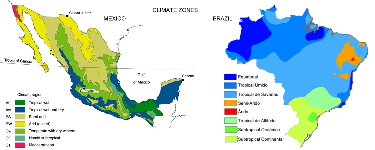
Climate zones of Mexico and Brazil. Credit: Geo-Mexico and Wikipedia, respectively.

This makes it easier to teach about the spatial patterns of Brazil than Mexico. Even though regional geography largely disappeared from U.K. schools in the 1970s, most examination syllabi for the equivalent of Grade 13 still required the study of countries at contrasting levels of economic development. Brazil was a relatively popular choice to represent either (initially) an LEDC (Less Economically-Developed Country) or (more recently) an emerging economy or “middle-income” country. Naturally, this led to textbooks based on Brazil.

If further evidence were needed that British schools have tended to ignore Mexico, then look no further than a recent article in Geography, the flagship journal of the U.K.’s Geographical Association, the leading subject association for all teachers of geography in the U.K.

Quoting its website,

The Geographical Association (GA) is a subject association with the core charitable object of furthering geographical knowledge and understanding through education. It is a lively community of practice with over a century of innovation behind it and an unrivalled understanding of geography teaching. The GA was formed by five geographers in 1893 to share ideas and learn from each other. Today, the GA’s purpose is the same and it remains an independent association.”

GEOGRAPHY_vol100_part3_COVERThe Autumn 2015 issue of Geography includes “Twenty-five years of Geography production”, an article by Diana Rolfe analyzing the content of the last 25 years of the publication. One particular section caught our eye. Rolfe lists the number of times that specific places are referred to over that time in the journal’s “place-based articles”.

The analysis shows that 78 countries were referred to in the past 25 years. The most frequently mentioned country (no surprise here) is the U.K., with (139 articles over the past 25 years). The next most frequently mentioned country is South Africa (27 mentions), followed by China (16), France (12), Australia (10), Hong Kong, Ireland and Canada (8 each). Latin American countries do not have a good showing on this list, but are represented by Peru (2), Argentina (1), Brazil (1) and Chile (1).

Astonishingly (to us at least) Mexico does not get a single mention. Neither, it must be said, do Sweden or Norway.

The omission of Mexico from the list is significant, given that it is the world’s 11th largest country in terms of total population, 14th largest in area, is the 9th most attractive country for FDI, and has the 11th largest economy on the planet!

It is an especially puzzling omission, in a U.K. context, given that U.K. investment during the nineteenth century helped unlock the mineral riches of Mexico, finance its banks, build its railway network and so much more.

We invite UK geographers to purchase a copy of Geo-Mexico, the geography and dynamics of modern Mexicocome or hop on over to geo-mexico.com to find out what they’re missing.

Related posts:

Qualitative fieldwork methods: auto-photography

 Teaching ideas  Comments Off on Qualitative fieldwork methods: auto-photography
Jan 132014
 

In an interesting recent article, Melanie Lombard of the Global Urban Research Centre of the University of Manchester in the UK describes how she used the fieldwork technique of auto-photography to explore the views of people living in two informal settlements in Xalapa, the state capital of Veracruz.

What is auto-photography?

Auto-photography is not the same as selfies! In auto-photography participants take photographs, choosing images and representations for themselves. Auto-photography typically entails a researcher giving cameras to research subjects and then asking them to photograph particular places and/or events.

Why use auto-photography?

Visual images are of great importance in geography. Geographers have utilized photographs and other images in their research and teaching for decades, paying considerable attention since at least the 1950s to the ways in which people respond to particular images, and how they interpret them. Auto-photography follows in this long-standing geographic tradition of recording and analysing visual images.

In particular, auto-photography “allows researchers to capture and articulate the ways identity guides human action and thought. It can generate more authentic data because it enables researchers to look at the participants’ world through the participants’ eyes. Auto-photography does this because participants themselves select and record the static images they feel represent them the best. This is a particularly critical issue for those who conduct research on the experiences of marginalized groups. Because auto-photography provides participants a chance to speak for themselves, it helps researchers to avoid exclusive reliance on potentially culturally biased research instruments.” (Noland, 2006)

In other words, auto-photography is one way to challenge the assumptions and generalizations often made by “outsiders”, even if they are researchers with the best intentions!

Lombard studied two informal settlements (colonias populares) in Xalapa: Loma Bonita and Moctezuma.

Xalapa, Veracruz

Xalapa, Veracruz (Mexico’s highest peak, Pico de Orizaba, in the background)

What method did she use?

Participants were given a camera and asked to take at least three photos to illustrate each of the following:

  • positive aspects of living in the neighborhood
  • negative aspects of living in the neighborhood
  • residents’ achievements in the neighborhood
  • special/typical characteristics of the neighborhood

Cameras were given to six selected individuals who were given a week to take a series of photos. During a follow-up interview, participants were asked about their motivations for having chosen particular locations to illustrate their neighborhood’s positive and negative aspects.

As Lombard points out, unlike the typically “negative framings” of informal settlements in most discussions, the images taken by the residents “convey a sense of everyday life taking place, amid hope and conviviality, as well as struggle and hardship”. Interestingly, photos of the local schools were taken by 5 of the 6 participants, with one 16-year-old teenager explaining how “in such an isolated neighbourhood, school is a service as significant as water or electricity”. There is a valuable lesson to be learned from the stark contrast between a photo of Loma Bonita school taken by the researcher, in which the school’s building and location are emphasized, and an image of the same school taken by one of the participants, who chose to photograph a group of students, accompanied by a teacher, engaged in a cultural activity in the playground.

Photos illustrating positive aspects of the neighborhood including a resident working a small plot of land for corn (maize) and one of a family butchering a pig. Such images underline the importance, as Lombard points out, of “understanding poverty from the point of view of the poor”, suggesting that residents view their neighborhoods not only as sites of hardship and discrimination, but also as “an important base for livelihoods”.

There are several financial and ethical considerations that also need to be considered. For example, should a financial reward be offered to participants? Might the offer of a financial reward change the level of commitment of participants and affect their choice of subject matter? In the context of Lombard’s study, she opted to give a copy of all photos to each participant, as well as giving them the opportunity to keep the camera that had been provided.

Lombard’s article is a valuable addition to the literature about qualitative fieldwork methods, though (as she takes pains to point out) the method does present “a set of specific ethical challenges” and the results of such studies may be difficult to interpret.

References:

Lombard, Melanie. 2013. Using auto-photography to understand place: reflections from research in urban informal settlements in Mexico. Area (RGS/IBG) 45:1, 23-32.

Noland, Carey M. 2006. Auto-Photography as Research Practice: Identity and Self-Esteem Research Journal of Research Practice, Volume 2, Issue 1.

Related posts:

Feb 022010
 

This link is to a blank outline map of Mexico (in pdf format), including state boundaries, but no cities or other features.

Blank outline map of Mexico

There are no restrictions on how this map may be used (no royalty is payable) but please credit geo-mexico.com if you download and use it in any report or in class.

We welcome comments on whether or not you found this map useful.
Please use the comments form if you wish to tell us about other maps that you would like to see on our site.