Search Results : jalisco

Mexico’s North-South economic divide weakens slightly in 2009

 Mexico's geography in the Press, Updates to Geo-Mexico  Comments Off on Mexico’s North-South economic divide weakens slightly in 2009
Mar 222010
 

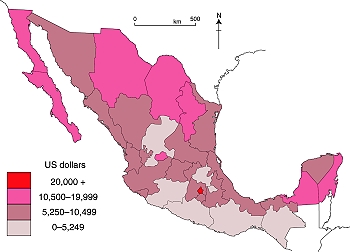
The rapid rates of economic growth in recent decades in the north of Mexico has led to a pronounced economic north-south divide, mapped and analyzed in some detail in chapter 14 of Geo-Mexico: the geography and dynamics of modern Mexico.

GDP/person in Mexico, 2007 (Color version of Fig. 14-3 of Geo-Mexico). All rights reserved.

In 2009, this divide weakened slightly. However, this was not so much a case of the south catching up but more a case of the north stumbling in its progress, due to its heavy reliance on economic ties to the USA.

Northern border states, where manufacturing is important, saw their GDP fall by more than 10% on average during 2009, according to Banamex’s Regional Economic Activity Indicators (Indicadores Regionales de Actividad Económica), published in mid-March. This decline in GDP was accompanied by a fall in employment and also by a significant fall in remittances sent home from Mexican migrant workers in the USA. It should be remembered, however, that these states all experienced marked rises in their GDP in the years immediately prior to the worldwide economic downturn.

No fewer than 29 of Mexico’s 32 states (counting the Federal District as a state for simplicity) saw their GDP decline in 2009. Only 3 states—Zacatecas, Chiapas and Oaxaca—bucked the trend and saw a rise in their GDP in 2009. In the state of Zacatecas GDP grew 1.6% (helped by a resilient construction sector), in Chiapas 1.1% and in Oaxaca 0.8%. It is noteworthy that none of these three states is particularly well integrated into the global economy. As a result, what was happening outside Mexico’s boundaries had little effect on their economic progress.

The list below gives the % change in GDP during 2009 for a sample of states, alongside the national average for comparison:

Zacatecas           + 1/6%
Chiapas               + 1.1%
Oaxaca                + 0.8%

State of México       – 5.6%
Jalisco                     – 6.0%
Federal District       – 6.4%
Querétaro               – 6.3%

National average    – 6.7%

Tamaulipas            – 7.8%
Nuevo León           – 9.3%
Baja California        -10.5%
Chihuahua              -13.6%
Coahuila                -14.4%
A brief history of geography in Mexico

 Other  Comments Off on A brief history of geography in Mexico
Feb 192010
 

Mexico has a long tradition of geography. Modern geography was given a jump-start in the country by the brilliant Prussian traveler Alexander von Humboldt, who explored Mexico for twelve months in 1803–04.

The Mexican Society of Geography and Statistics was founded in 1833, only three years after the UK’s Royal Geographical Society and fully 55 years before the National Geographic Society. Geography remains a popular and respected subject in Mexican high schools and universities.

Even prior to Humboldt, many authors had made valuable descriptions of many aspects of Mexico’s geography. Writing in the mid-17th century, but looking back to a century earlier, Father Antonio Tello, in describing the province of Xalisco (Jalisco) offers lots of information about plants, animals, natural hazards, rivers and natural hot springs, while speculating about whether underwater springs fed Lake Chapala, Mexico’s largest natural lake.

Though many volumes have been lost, the surviving parts of the Geographic Accounts written at the end of the 16th century are a veritable “Domesday Book” of information.

After Humboldt, however, geography set off on a much more scientific, analytical path, one which has continued to the present day and which has now resulted in Richard Rhoda and Tony Burton’s Geo-Mexico: the geography and dynamics of modern Mexico.

Mexico’s indigenous place names

 Teaching ideas  Comments Off on Mexico’s indigenous place names
Feb 172010
 

Mexico’s place names, or toponyms, offer many clues about geography. Mexico’s indigenous peoples spoke languages that had no formal alphabet. For place names, they used combinations of pictographs, ideographs and phonetic symbols.

Spanish explorers recorded the names provided by the locals as best they could, resulting in some inevitable confusion and distortion. For instance, it is sometimes claimed that “Yucatán” actually derives from Maya Indians responding, “I don’t know!” when asked to name a nearby place.

Suffixes derived from indigenous (mostly Nahuatl) words include:

  • -apan = in/near water or river
  • -calco = in the house of
  • -can = place
  • -cingo, -tzingo = (small) place of settlement
  • – huacan, -oacan = place where they have
  • -pan = in/on
  • -ro = place
  • -tepec = hill
  • -tepetl = mountain
  • -titlan = near
  • -tla = abundance
  • -tlan = in or near

Can you think of examples of modern-day place names using each of these suffixes? For instance,  “Zapopan”, in the state of Jalisco, is an example of a place name ending in -pan = in/on.

[Edited extract from chapter 1 of Geo-Mexico: the geography and dynamics of modern Mexico]

Giant whirlpool swallows several boats in 1896

 Other  Comments Off on Giant whirlpool swallows several boats in 1896
Feb 152010
 

An anonymous writer in the Los Angeles Times edition of 13 January 1896, reported on a strange and terrifying happening that struck the western part of Lake Chapala (Mexico’s largest natural lake)…

Startling Spectacle at Lake Chapala.

  • Its Waters Swallowed by a Subterranean Cave.
  • Several Pleasure Boats and Their Occupants Engulfed.

SAN DIEGO, Jan. 12.—(Special dispatch.) Prof. E. H. Coffey of this city, has just received a letter from a correspondent. living near Lake Chapala, State of Jalisco, Mex.. which describes some startling phenomena occurring. Lake Chapala is a sheet of water fifty miles long and ten miles wide. The formation of the country around it is purely volcanic.

On the forenoon of January 8 residents in one of the small settlements near the western end of the lake were terrified to see a gigantic whirlpool raging far out on the water. The waters rose in great serpentine movements, and from all directions rushed toward a common center, where a vast cavity seemed to exist. At the same time a heavy, rumbling sound, apparently in the bowels of the earth, took place. The whirlpool was caused by the sudden sinking of a large portion of the lake’s bottom, and before the disturbance subsided several pleasure-boats were drawn into the whirlpool and disappeared with their occupants. It is estimated that a score of lives were lost.

The whirlpool continued for nearly twenty minutes, and when the inhabitants of the surrounding territory turned their eyes from the overwhelming sight they saw that the lake had receded several feet from its former shore line. As the lake is about fifty miles in length, with an average width of ten miles, the enormous amount of water that was swallowed up by the earth may be imagined. After the whirlpool subsided the surface of the lake resumed its placid aspect, and the subterranean rumblings ceased.

There was the greatest excitement among the people for miles in the vicinity of the western end of the lake, the most ignorant and superstitious natives being beside themselves with fear. Years of familiarity with volcanic eruptions and terrestial disturbances did not seem to reassure them during this dreadful experience.

[This post is an edited extract from Lake Chapala Through the Ages, an anthology of traveller’s tales]

Natural hazards in Mexico are discussed in detail in chapters 2, 4 and 7 of Geo-Mexico: the geography and dynamics of modern Mexico.

The geography of Mexican cuisine

 Other  Comments Off on The geography of Mexican cuisine
Feb 102010
 

Mexican cuisine is extraordinarily varied and has become one of the most popular in the world. Diana Kennedy, the foremost authority on the subject, has devoted her life to researching the regional variations in ingredients, cooking methods and typical local dishes.

The ingredients used reflect different climates and ecosystems (see Geo-Mexico chapters 4 and 5). For instance, corn (maize) tortillas predominate in southern and central Mexico while wheat tortillas are more commonly found in the north of the country.

Pork and hominy stew (pozole) is largely restricted to the Pacific coast states of Jalisco and Guerrero. The grilled beef of cattle ranges in the northern interior of Mexico contrasts with the seafood found along the coast.

Cuisines are strongly influenced by trade routes and migration, especially the arrival of immigrant groups. Mexican cuisine is a fusion of  ndigenous and Spanish cooking, influenced in some regions by Cuban, Italian, French and other migrants.

On a more local scale, miners from Cornwall in the UK who came to work in the silver mines of Real del Monte in the state of Hidalgo brought with them their meat and vegetable-filled pastries called Cornish pasties. These were quickly assimilated into the local cuisine, and pastis, admittedly with some chilies added, are still sold in the town.

[Note: This post is an edited extract from chapter 13 of Geo-Mexico]

For more about Mexican cuisine, visit the amazing award-winning blog Mexico Cooks! and also browse the huge selection of recipes, articles and tips about all aspects of Mexican food and cooking in the “Cuisine” section of MexConnect. ¡Buen provecho!

Geo-Mexico talk in ACÁ eco-series

 Other  Comments Off on Geo-Mexico talk in ACÁ eco-series
Jan 112010
 

UPDATE – This post has been edited to reflect the fact that ACÁ closed in mid-2011.

Geo-Mexico author Tony Burton, aided by Richard Rhoda, gave a presentation today about “Man and Nature in Mexico” as a fund-raiser to a good-sized group of ACÁ supporters.
ACÁ was a non-profit organization in Mexico that promoted sustainable farming and resource use, and had made a considerable positive impact on hundreds of villagers in the Lake Chapala region of Jalisco. The talk was well received and some great questions were asked, which we will try to answer more fully in future posts on this blog. They included a request for more details about the highly productive chinampa system of food production which dates back to pre-Hispanic times. Watch this space for more details in the near future!