Video of the Sea of Cortés (Gulf of California)

 Books and resources  Comments Off on Video of the Sea of Cortés (Gulf of California)
Aug 232016
 

This PostandFly video explores the islands of San Jose, San Francisco and Espiritu Santo. The Sea of Cortés (Gulf of California) is the body of water that separates the Baja California Peninsula from the Mexican mainland. The Sea of Cortés is thought to be one of the most diverse seas on the planet, and is home to more than 5,000 species of micro-invertebrates. A large part of the Sea of Cortés is a UNESCO World Heritage Site.

Several rivers feed the Sea of Cortés, including the Colorado, Fuerte and Yaqui. The Sea of Cortés has more than 300 estuaries and other wetlands on its shores, of which the delta of the Colorado River is especially important. The vast reduction in the Colorado’s flow has negatively impacted wetlands and fisheries.

Previous Geo-Mexico posts on this area of Mexico include:

May 252015
 

The Mexican government is funding a 100-million-dollar project to build Mexico’s first cruise ship home port at Puerto Peñasco (Rocky Point) in Sonora on the Sea of Cortés (Gulf of California). Construction began in 2013 and is scheduled to be completed by early in 2017.  Proponents hope that the port will help transform the existing town (population about 60,000) into a fully-fledged tourist resort, taking advantage of its proximity to Phoenix and Tucson in Arizona. The project includes a state-of-the-art terminal and convention center.

pinacate-map-google

The town already has a small international airport, inaugurated in 2008, which has a daily capacity of 2000 passengers and would need to be expanded if the port takes off.

Puerto Peñasco has an embryonic tourism industry at present, mainly attracting Arizonans (it is their nearest beach), fishing enthusiasts, and school and college students during spring-break (attracted, in part, by the legal drinking age being 18 in the town, compared to 21 in Arizona).

puerto-penasco

Puerto Peñasco also has research stations of the Universidad de Sonora: its Centro de Investigaciones Científicas y Tecnológicas (Scientific and Technological Research Center) and its Centro de Estudios del Desierto (Center for Desert Studies).

According to cruise line statistics, the number of Mexicans taking cruises in 2014 rose by 15%, but analysts argue that many Mexicans stay at home and are unable to take cruises at present because they lack a U.S. visa. Establishing a home port in Mexico, they argue, would therefore open up a significant new market. A cruise ship port at Puerto Peñasco would clearly have immense impacts on the town, boosting the local economy and generating up to 2,500 direct and 5,000 indirect jobs.

However, critics say this will come at a cost. They cite potential problems related to local residents, wildlife and biodiversity. They fear that development of the town will raise property prices beyond the level of affordability of local residents. A Tucson-based non-profit, The Intercultural Center for the Study of Deserts and Oceans is working with local fishermen and government agencies to “empower coastal communities in the Northern Gulf of California region with the knowledge and tools to create sustainable livelihoods that exist in concert with the surrounding natural and multicultural environment”. The research center believes the port development will lead to environmental changes adversely affecting important fishing grounds. The center has also expressed concern about the potential hazards to nesting sites used by sea turtles.

Related posts:

The mystery of the Alarcon Rise

 Updates to Geo-Mexico  Comments Off on The mystery of the Alarcon Rise
Dec 292014
 

Geologists have discovered that some strange things are happening off the southern coast of the Baja California Peninsula.

In essence, while most of Mexico rests on the North American plate, the Baja California Peninsula is on the gigantic Pacific plate. The Pacific plate is moving slowly northwest and the pressures in the zone where these two plates intersect, under the Sea of Cortés (Gulf of California), has caused a complex series of parallel faults which (further north) link to the California’s San Andreas Fault system. Thus, the Sea of Cortés is an area of heavy seismic activity.

The Alarcón Rise is a 31-mile-long (50 kilometer) spreading center at the mouth of the Gulf of California. Along ocean spreading ridges like the Alarcón Rise, the seafloor is splitting apart as lava wells up from underneath. Credit: (c) 2012 MBARI

Location of the Alarcón Rise. Credit: (c) 2012 MBARI

The Alarcón Rise (see map) is a 50km (30 mi) long “bump” under the Sea of Cortés. New seafloor is being continuously created along the Alarcón Rise as undersea magma rises to the surface and cools to become lava. As the plates continue to move, this lave is then carried away to either side of the Alarcón Rise, allowing fresh lava to take its place, and so on. The rate of sea-floor spreading here is a relatively slow 5 cm (2 in) a year.

The Alarcón Rise has been studied in considerable detail by geologists attached to the Monterey Bay Aquarium Research Institute (MBARI) in California. Using a sonar-mapping robot, they discovered new deep-sea hydrothermal vents.

But their most surprising find was a “Weird Underwater Volcano.

In most zones of sea-floor spreading, the lavas are relatively low in silica and therefore free-flowing. Such lavas are known, on account of their chemistry, as “basic” lavas. (Lavas higher in silica, known collectively as acid lavas, tend to be more viscous and flow less easily. Acid lava volcanoes tend to erupt far more explosively than basic lava volcanoes.)

The curiosity of the Alarcón Rise is that while the vast majority of lava flows along the ridge are basic (basalt) lavas, those associated with at least one volcano are clearly acidic, not basic.

Researchers used a remote-control vehicle to collect samples and explore the volcano, which is 2375 m (7800 ft) below the surface. Samples of the lava show that it is primarily rhyolite with some dacite, with a silica content of up to 77%, the highest of any rock ever found along a mid-ocean ridge, according to Brian Dreyer, a geochemist at the University of California, Santa Cruz. The volcano with acid lava forms a small dome, about 50 meters (165 ft) in height and covers an area of about 1200 meters by 500 meters (4000 feet by 1640 feet). The dome is probably several thousand years old.

The lavas solidified quickly to form angular chunky blocks, some of which then rolled down the sides of the rise to form talus (scree). The individual blocks can be as large as cars or small houses.

The findings suggest that this particular volcano could give rise to hazardous eruptions. It is only 100 km (60 mi) from land and very close to the major tourist areas fringing the coast of Baja California Sur. Any major explosive eruption from this volcano could also cause a tsunami with the potential to devastate settlements on both coasts of the Sea of Cortés (Gulf of California).

Geologists are still working on trying to fully explain this apparent anomaly in lava composition. They have already discarded several ideas, and their current hypothesis is that the magma source was at some point contaminated by seawater, resulting in an unusually high concentration of volatiles such as water, sulfur and chlorine.

Related posts:

May 092014
 

We have repeatedly questioned the long-term wisdom of large-scale tourist developments along Mexico’s coastline. See, for example:

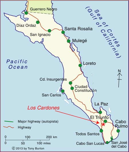
The good news, in June 2012, was that it looked as if the conflict at Cabo Pulmo, in Baja California Sur, had been resolved in favor of protecting the environment:

Unfortunately, land developers won’t take “No” for an answer. Immediately after its “cancellation”, the Cabo Cortés project was renamed Los Pericúes and relaunched, with few if any differences from the original version. Two years on, the project has been taken over by a new consortium of developers and renamed “Cabo Dorado”. Some changes have been made along the way, and Cabo Dorado no longer includes a marina or desalination plant, and its plans appear to have a lower building density.

There are still some legitimate concerns about the long-term impact of such a project in this area, so kudos to Carolina Herrera (Latin America Advocate of the Natural Resources Defense Council in Washington DC) for her impassioned plea calling for Cabo Pulmo to be protected from the latest incarnation of this long-proposed tourist megaproject.

The project is located immediately north of the Cabo Pulmo Marine Park, which over its 19 year lifespan has proven to be hugely successful in conservation terms (The extraordinary ecological recovery of Mexico’s Cabo Pulmo Marine Park), while providing local people with the opportunity to offer a variety of alternative forms of low impact tourism. The site of the Cabo Dorado project site is home to 26 “at risk” species, including endemic plants and endangered sea turtles.

Cabo Dorado is a 3.6-bilion-dollar joint investment by La Rivera Desarrollos BCS, a joint venture of Glorious Earth Group (USA) and Beijing Sansong International Trade Group (China), together with China State Construction Engineering Corporation.

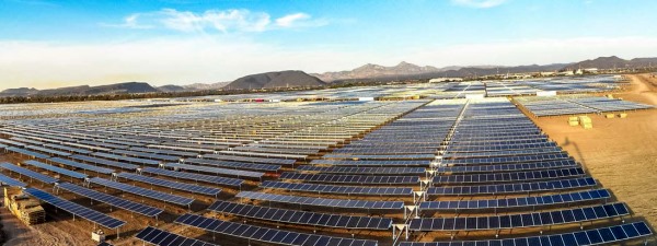
The project is for the construction of a new “ecotourist city” on 3770 hectares (9317 acres) of land. Slightly more than two-thirds of this area will be retained as a “conservation reserve”.

The master plan for the developed third includes:

  • 6,141 homes  (443 ha)
  • 9 hotels with 4,080 hotel rooms (721 ha) [the 22,503 number on the infographic below is an error]
  • 2 golf courses and practice ground (162 ha)
  • Services, infrastructure, maintenance (334 ha)
  • 1 landing strip
  • 1 14-km aqueduct
  • Shops, convention center, etc
Infographic from www.cabopulmovivo.org

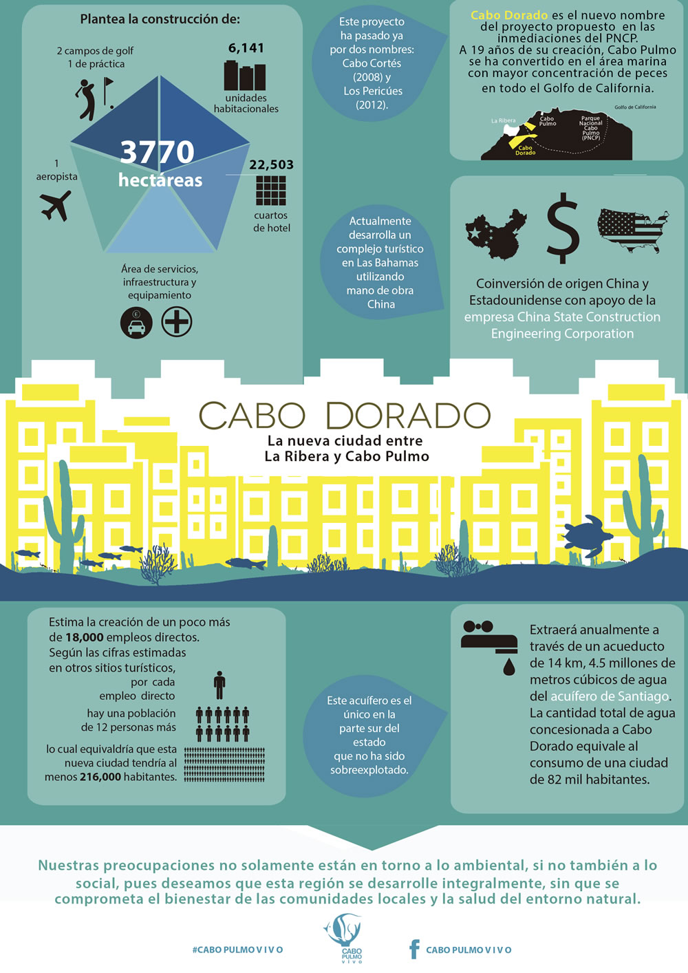
Infographic from www.cabopulmovivo.org   Click to enlarge

According to the developers. Cabo Dorado “will be a fully integrated development, a first of its kind in the country, as it combines educational, recreational activities, scientific research, health promotional centers and a strong commitment to preserve the environment.” To this end, the project includes “an interpretation center, a technological and biological research center for studies related to the Sea of Cortes and the Desert of Baja California Sur, as well as a cultural exchange center, an educational institute and a student campus. In addition, there will be centers dedicated to the promotion of trade and investments, a high performance sports center, 9 world-class hotels and residences for temporary visitors and full time residents.”

Cabo Dorado will extract up to 4.8 million cubic meters of water a year from Santiago aquifer, roughly equivalent to the water needs of a city of 82,000 people) and will generate 711,900 kilograms of waste per day.

On the positive side, the project will create 18,000 direct and indirect jobs and bring around 900 million dollars/year into this area. It does not involve a marina or pumping wastewater into the sea which should prevent direct adverse ecological impact on marine life. The masterplan includes a “support town” for workers, which means that the local municipality does not need to build additional infrastructure to support the project.

The Mexican Center for Environmental Law (CEMDA) has called for a formal public meeting and consultation to ensure people are adequately informed about the latest plans and the potential social and environmental impacts.

Further reading:

For an exceptionally informative series of papers (in Spanish) on all aspects of tourism and sustainability in Cabo Pulmo, see Tourism and sustainability in Cabo Pulmo, published in 2008 (large pdf file).

Related posts:

Apr 122014
 

On Thursday, 27 March 2014, Mexican and U.S. officials were on hand to witness a release of water from the Morelos Dam (located on the border, see map) that should help to rejuvenate wildlife in the Colorado River delta. The delta area has been dry for many years.

Map of the Colorado delta

Map of the River Colorado delta. All rights reserved. Click to enlarge.

The agreement between Mexico and the USA allows for a “pulse flow” of water to be released down the Colorado River, which will bring water to the river’s delta in the Sea of Cortés (Gulf of Mexico) for the first time in more than five decades. The pulse is designed to mimic the effects of a springtime snow melt. The pulse flow will amount to a total of 130 million cubic meters of water over a period of eight weeks.

Within 48 hours of the initial release, the water had reached about 50 km (30 miles) downstream, with some of the water infiltrating into the barren soil as it went. The scientists monitoring the release are still unsure whether or not any water will make it as far as the sea, but already there are signs of life returning to the delta region:

  • Update From Colorado River Delta: A Community Gets its River Back

The release of water is part of a pilot project, due to last five years, that will lay the groundwork for possible future agreements to ensure that the delta area receives sufficient water in the future to enable its fauna and flora to survive.

For more about this landmark event, see

You can help restore water to the Colorado River Basin by joining (free) Change the Course, a project of National Geographic and partners. 

Related articles:

Latin America’s biggest solar energy plant helps power La Paz

 Mexico's geography in the Press, Updates to Geo-Mexico  Comments Off on Latin America’s biggest solar energy plant helps power La Paz
Mar 312014
 

Latin America’s largest solar power plant is now supplying power to the city of La Paz in Baja California Sur. The Aura Solar I photovoltaic power plant has an installed capacity of 30 MW. The plant was officially inaugurated on 19 March 2014, and will supply about 82 GWh/year of electricity to around 164,000 residents of La Paz, more than two-thirds the city’s total population of 220,000. It is located a short distance east of the city, and replaces an old, air-polluting thermoelectric plant.

Auro Solar 1 project, La PazThe new power plant, owned by Corporación Aura Solar, is the largest photovoltaic power plant in Latin America, according to company chairman Daniel Servitje Montull. The 100-million-dollar plant occupies 100 hectares (250 acres) and was constructed by engineering firms Gauss Energía and Martifer Solar. The project relies on about 131,800 solar panels and has an estimated operational life of 30 years. About 25% of Mexico’s electricity is currently generated using clean energy sources. Mexico has set a national target of 35% clean energy by 2024, in order to minimize Mexico’s contribution to global climate change.

This 2-minute YouTube video shows various stages in the building of the plant:

Related posts:

Plan for open-pit gold mine in Baja California Sur rejected

 Books and resources, Mexico's geography in the Press  Comments Off on Plan for open-pit gold mine in Baja California Sur rejected
Oct 122013
 

In November 2012, the federal Environment and Natural Resources Secretariat (Secretaría de Medio Ambiente y Recursos Naturales, Semarnat) refused a request to allow open-pit (opencast) mining in the buffer zone of the Sierra La Laguna Biosphere Reserve in Baja California Sur.

The request came from Zapal SA de CV, whose mining project, currently named “Los Cardones”, is located about 60 km from La Paz, the state capital. The proejct is close to the small settlements of El Triunfo, San Antonio and El Rosario. This mining project was previously called “Paredones Amarillos” and “La Concordia”. The original Concordia project, proposed by US mining firm Vista Gold and Toronto-listed Argonaut, was opposed on environmental and public health grounds by several environmental groups including the Mexican Center for Environmental Law (CEMDA).

Location of Los Cardones mining project. Credit: Tony Burton/Geo-Mexico

Location of Los Cardones mining project.

The latest version, Los Cardones, was resubmitted to authorities in September 2012. The project involved 423 hectares of semi-arid scrub-land, from which Zapal hoped to extract 40 metric tons of gold in the next decade using open-cast (pit) mining. The $217-million project would have created around 2200 jobs.

According to the project’s website (no longer functional), the mining project would have relied entirely on desalinated seawater (brought to the site by a 40-km aqueduct), which would be continuously recycled, and would therefore have no impact on local aquifers. Zapal claimed that the mine would have been the first gold mine in Mexico to use a closed-system cyanidation process, designed to prevent any contamination of the local environment. Zapal is part of the Invecture group which already operates an open cast copper mine in Piedras Verdes, Sonora, claimed to have an impeccable environmental and safety record.

Semarnat rejected the proposal on the grounds that it did not meet the legal requirements for mining operations in a Biosphere Reserve buffer zone. It is likely that a revised application will be made in due course. However, officials of the Baja California state government have previously gone on record as saying that they will oppose any open-cast mining in the state, because of its potential environmental impacts.

Anti-mining protests elsewhere in Mexico

David Bacon, author of “The Right to Stay Home: How US Policy Drives Mexican Migration”, wrote an informed account for the American Program website of several cases across Mexico where opposition to Canadian mining firms has arisen.

  • Mexican Farmers Up Against Canadian Mining Goliaths

A Guardian photo essay entitled “Mexico mining: ‘When injustice is law, resistance is duty’ – in pictures” reported on a January 2013 meeting of some 500 activists from across Mexico and Central America in Capulálpam de Méndez, Oaxaca. The meeting’s slogan was,  “Si la vida! No la
minera!” (Yes to life! No to mining!). It was held to co-ordinate local resistance to the human and environmental costs of mining on the region’s communities.

Related posts:

Feb 222011
 

The Baja California peninsula is one of the most arid areas in Mexico and water shortages are becoming critical, especially along the southern coastline which has matured into one of the most desirable jet-set locations in the world.

Desalination, which involves removing the salts from seawater or brackish water to provide drinking water, is one viable option to ensure future water security for the region. There are already about 70 desalination plants on the Peninsula, though most are very small (25 liters/second or less) and are powered by conventional electricity. Several larger desalination projects on the Baja California Peninsula, some of which will rely mainly on solar power, are currently in the planning stages.

Map of Baja California PeninsulaLa Paz, the capital of the state of Baja California Sur, faces a particularly serious water supply problem. The local aquifer is reported to be already overexploited and suffering from salt water intrusions. Because of its greater density, seawater normally underlies freshwater in coastal areas. Salt water intrusions occur when so much fresh water is pumped out of coastal aquifers that it is replaced by the underlying salt water. The water supply issues have led to water rationing, in which almost half of La Paz’s 250,000 residents receive water only 12 hours or less each day.

Obtaining water from the desalinization of sea water is more expensive than abstracting water from aquifers via wells, but avoids the possibility of salt water intrusions.

A recent Ooska news article provides details of the desalination plants already built or being planned:

Baja California Sur:

Cabo San Lucas, opened in 2007, treats approximately 230 liters a second (60 gallons/s), equivalent to 20 million liters (5 million gallons) a day.

La Paz. Still at the proposal stage is a desalination plant capable of treating 200 liters a second.

Sierra de la Laguna. A Canadian mining company (Vista Gold Corp.) planned a desalination plant to provide water for its proposed Concordia open-pit mine. However, the mining plan was refused an essential permit by the Mexican government.

Baja California:

Ensenada. The 28-million-dollar El Salitral desalination plant is a “highly innovative project that would put the region on the map globally for desalination”. Construction is due to start later this year, and the plant should be operational by the end of 2012, when it will treat 250 liters of seawater a second. The plant would supply 96,000 people with potable water.

Rosarito. Preliminary geological and environmental impact studies are underway for a desalination facility in La Misión large enough to supply the needs of 96,000 people. Still in the concept stage is a second desalination plant  which would supply water across the border to San Diego in California.

San Quintín. Plans exist for a desalination plant with a capacity of 150 liters a second.

Main source: The OOSKA News Weekly Water Report for Latin America and the Caribbean (16 February 2011)

Want to read more?

Map of Baja California Peninsula

 Maps  Comments Off on Map of Baja California Peninsula
Mar 032010
 

The map shows Mexico’s Baja California Peninsula. This includes the states of Baja California, the northern section of the peninsula, and Baja California Sur. The state capital of Baja California is Mexicali; the state capital of Baja California Sur is La Paz.

Note: There is no such state as Baja California Norte, despite this name being used on some websites!

Click here for the interactive version of this map on MexConnect website

Want to read more?