Bringing place names to life in Mexico City

 Books and resources  Comments Off on Bringing place names to life in Mexico City
Aug 022010
 

I love gifts, especially books, and especially when they are related to the geography of Mexico!

So, it was a doubly pleasant surprise recently to receive a copy of Glifos de la ciudad de México by Pablo Moctezuma Barragán (Gobierno del Distrito Federal, 2006; 103 pp.)

The author is an accomplished researcher, historian and politician who holds a teaching position at the Azcapotzalco campus of the Universidad Autónoma Metropolitana, and who spearheaded a campaign in Mexico City to bring the meanings of place names to life.

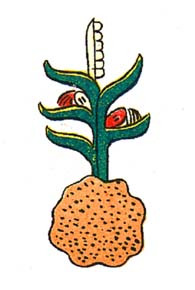
Atocpan = "On fertile soil"

Atocpan = "On fertile soil"

The project involved the installation around the city in 2006 of more than 300 works of art, all using traditional Talavera tiles, depicting pre-Hispanic glyphs, together with a brief explanation of their derivation and meaning. Each mosaic of 25 tiles measures one meter by one meter.  The vast majority of the glyphs are depicted as they are known in ancient codices or other historic sources, but in a few cases, glyphs have been specially created, faithfully reflecting  the ancient principles. Glifos de la Ciudad de México is a handy pocket guide to these glyphs.

The obligatory introductory statements by politicians are mercifully brief, though significantly for us, they do refer to the fact that many names depend on a circunstancia geográfica (a geographical circumstance) or are related to activities undertaken by the early settlers or to characteristic plants or animals. How encouraging to see such a tribute to geography!

Next comes a very interesting essay by Pablo Moctezuma Barragán, setting the scene for the full color illustrations of hundreds of glyphs which follow. The author discusses the origins of place name glyphs (the oldest date back 2500 years), and emphasizes that many reflect the importance of local geographic conditions. The forces of globalization may be at work in what is arguably the world’s largest city, but “It is important to rescue our roots”, argues Moctezuma Barragán, “We should not live like foreigners in our own land”.

He goes on to summarize the Nahuatl roots of many of the names and gives a potted history of the development of Mexico City.
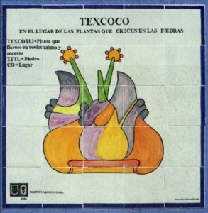
Tile mosaic depicting glyph of Texcoco

Tile mosaic depicting glyph of Texcoco ("in the place where plants grow on rocks") on a wall in Mexico City. Credit: Glifos de la ciudad de México.

All the glyphs refer to names used somewhere in the city and many photographs show the commemorative tiled versions in situ in the city. In all, 322 glyphs were installed, and more than 220 of them are included in this book.

This is but one example of the many projects undertaken by Mexico City authorities in recent years to beautify the city.

What a neat idea, to introduce people, even as they go about their daily lives, to pre-Hispanic symbolism as it relates to local place names. These tiled works of art are a great way to encourage a sense of place and identity. They are not only beautiful, they serve to foment local pride.  Geography is alive and well in Mexico City!

Related website.

Several hundred ancient glyphs, from Antonio Peñafiel’s 1885 “Nombres Geográficos de México,” can be viewed online as part of the Aztec Place Name Glyphs Project of the Department of Geography at the University of California, Berkeley.

Previous posts about Mexico’s place names:

Many Mexican place names were changed following Mexican Independence (1821)

 Other  Comments Off on Many Mexican place names were changed following Mexican Independence (1821)
Jun 102010
 

This is the fourth and final part of our series of guest blogs by Fatimah Araneta.

Fatimah Araneta grew up in Mexico City. After gaining a Masters in City Planning at Berkeley, California, she opted to eschew city life and direct her energy and attention to living in tune with what’s left of Mother Earth before it all gets paved over and criss-crossed with cabled and non-cabled networks. She lives “off the grid” in the shadow of the volcano she prefers to call Chicnautécatl.

Part 4 – Many Mexican place names were changed following Mexican Independence (1821)

Finally, we come to what León-Portilla calls the fourth layer in a place name: the part applied during Mexico’s independent era. The purpose usually was to deliberately erase names that were too Castilian for the newly-born nation’s taste, as in the case of the state of Jalisco, which used to be Nueva Galicia, or Tamaulipas, which was formerly called Nuevo Santander. Both Jalisco and Tamaulipas are prehispanic names.

Sometimes the new place name was to honor a war hero. Today’s Ciudad Hidalgo used to be Tajimaroa; Ciudad Juárez’s old name was El Paso del Norte (today the city to the north of the border from Ciudad Juárez retains part of that name: El Paso, Texas).

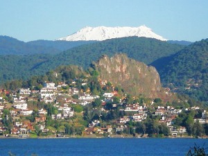
And coming back to the domains of the Nevado/Xinantécatl/Chicnautécatl, there is a small city about an hour’s drive to the west of the volcano with a place name history of its own. Nine hundred years ago it was a densely populated area, the focus of pilgrimages and of commerce, a place where produce, goods, news and ceremonies were exchanged between the people of the altiplano (the higher, cooler plains) and those of tierra caliente (the warmer lowlands). The Nahuatl name for it was Temascaltepec, “Place of the Hot Vapor Baths”.

Valle de Bravo

Valle de Bravo. Photo: Fatimah Araneta. All rights reserved.

Since it was contained in an ample valley, the Spaniards began to call it Valle de Temascaltepec. During the war for independence, the hero Nicolás Bravo and his army passed nearby, on their way from Chilpancingo to what is the state of Morelos today. Admittedly, none of them actually spent not even a night in Valle de Temascaltepec, but the proximity of their famously brave passage was enough for the the town to decide one day to drop the Temascaltepec and change its name to Valle de Bravo[1].

In view of all this one can only conclude that there is a great deal in a name, especially in a place name in Mexico, and that to wholly or partially modify a place name is to risk losing an important part of the memory of its past.

This concludes our mini-series on Mexican place names.

Bibliography

GARCÍA MARTÍNEZ, Bernardo, Los Nombres del Nevado de Toluca, in Arqueología Mexicana, Vol.VIII, no.43, pp.24-26, May-June 2000.

LEÓN-PORTILLA, Miguel, Toponimia e Identidad, in Arqueología Mexicana, Vol.XVII, no.100, pp. 28-33, November-December 2009.

SIERRA CARRILLO, Dora, San Miguel Arcángel en los Rituales Agrícolas, in Arqueología Mexicana, Vol.XII, no.68, pp74-79, July-August 2004.


[1] The dropped name was quickly claimed by a neighboring town, Real de Abajo, “Lower Mine”. It is one of twin towns located in an area of silver and gold mines (reales, in Spanish). The other town is called Real de Arriba, and still conserves that name. Real de Abajo must have felt uncomfortable all its life with its lowlier designation and quickly adopted the more elegant Temascaltepec to make up for its previous existence in the shadow of the “Upper Mine”.


Click on the word “placenames” or the “placenames” tag for more articles about Mexico’s place names.

The Spanish arrive and change lots of place names

 Other  Comments Off on The Spanish arrive and change lots of place names
Jun 072010
 

This is the third in our series of guest blogs by Fatimah Araneta.

Fatimah Araneta grew up in Mexico City. After gaining a Masters in City Planning at Berkeley, California, she opted to eschew city life and direct her energy and attention to living in tune with what’s left of Mother Earth before it all gets paved over and criss-crossed with cabled and non-cabled networks. She lives “off the grid” in the shadow of the volcano she prefers to call Chicnautécatl.

Part 3 – How the Spanish colonization of Mexico contributed to its place names

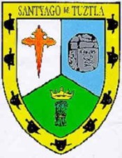
Santiago Tuxtla coat of arms

Santiago Tuxtla coat of arms

The third layer was bestowed by the Spanish colonizers. Some places received the names of cities in Spain, such as León (in the state of Guanajuato) or Córdoba (in the state of Veracruz). Sometimes the original Nahuatl was maintained but mispronounced so much that the name became corrupted, as in Churubusco, which used to be called Huitzilopochco. Some other times the name of a saint was added to the place name, as in Santiago Tuxtla, Santa Teresa Tiloxtoc or San Miguel Chapultepec.

The choice of the saintly counterpart to an already existing place name was hardly ever a frivolous decision. The different religious orders who set out to convert the indigenous populations to Christianity had their preferences. The Franciscans, for example, relied on Saint Michael to be their champion in the battle against the devils of the New World. Luckily for the evangelizing friars, Saint Michael also happened to possess attributes that made it easy for this religious icon to be accepted by the potential converts.

In the Old World, apparitions of Saint Michael had first taken place on mountaintops (high places near heaven from which he had banished Lucifer) and caves (since he was also in charge of assisting departing souls into the netherworld). Later, he would become involved in miraculous apparitions of springs of water, as in Mont Saint Michel in northern France, and was henceforth increasingly associated with the agricultural cycles of sowing and harvest.

At the same time, a very important figure in the prehispanic pantheon was Tláloc, the rain god, venerated too on mountaintops and at the entrances of caves, since it was believed that mountains were the containers of the weather. It was to Tláloc that one turned to ask for abundant rain for the crops, as well as mercy from the snakes of fire, or lightning bolts, that could inflict so much damage. Images of Tláloc depict him holding a bolt of lightning in one hand, not very differently from how images of Saint Michael show him wielding a flaming sword.

Thus, with this third layer of meaning, a place name in Mexico gives many clues to the past. If  “San Miguel” is part of the name it could be telling us that Franciscan friars had been in charge of the place at one time; that there could have been a cult to Tláloc; that the place was and could still be of hydrological importance; and that it could have been and could still be the focus of religious pilgrimages related to agricultural cycles.

The next part will consider how some Mexican places were rechristened during Mexico’s independent era (post 1821).

Click on the word “placenames” or the “placenames” tag for more articles about Mexico’s place names.

Mexican place names often have their roots in pre-Hispanic languages and have multiple levels of meaning

 Other  Comments Off on Mexican place names often have their roots in pre-Hispanic languages and have multiple levels of meaning
Jun 032010
 

This is the second in our series of guest blogs by Fatimah Araneta.

Fatimah Araneta grew up in Mexico City. After gaining a Masters in City Planning at Berkeley, California, she opted to eschew city life and direct her energy and attention to living in tune with what’s left of Mother Earth before it all gets paved over and criss-crossed with cabled and non-cabled networks. She lives “off the grid” in the shadow of the volcano she prefers to call Chicnautécatl.

Part 2 – Mexican place names often have their roots in pre-Hispanic languages, and have multiple levels of meaning

In the first part, we looked at the possible origins of Chicnautécatl or Xinantécatl, aka El Nevado de Toluca, Mexico’s fourth highest peak. In this part we start to consider Miguel León-Portilla’s view that a single place name in Mexico can have up to four distinct levels of meaning.

The first layer of meaning is more often than not a geographical description of the place in the language of its original inhabitants. Two examples in Oaxaca are Yodzo Coo, which in Mixtec means “Plain of the Snakes”, and Yacu Dzaa, Mixtec for “Hill of the Bird”.

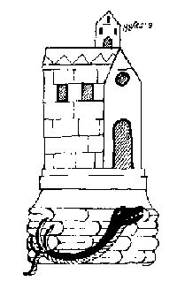
coixtlahuaca

Coixtlahuaca (place of snakes)

The second layer is generally in Nahuatl, as the expansion of the Aztec empire made this language the lingua franca over an extensive territory over the course of several centuries. The Nahuatl name would almost always be a translation of the first place name. For example, the above mentioned Yodzo Coo was renamed Coixtlahuaca.

On other occasions, the Nahuatl name would be another geographic appreciation of the place, but this time from the viewpoint of the Aztecs. For example, the region occupied by the Purépecha nation was called Mechuaca, which is Nahuatl for “Place of Fish”. That region is roughly what today is the modern state of Michoacán. The Purépecha simply called their territory P’urhépecheo, “Place Where the P’urhé Live”, p’urhé meaning people, referring to themselves.

The next part in this mini-series will look at how a third layer was often bestowed on Mexico’s placenames by the Spanish colonizers who arrived in the early 16th century.

Click on the word “placenames” or the “placenames” tag for more articles about Mexico’s place names.

How Mexico’s fourth highest peak got its name

 Other  Comments Off on How Mexico’s fourth highest peak got its name
Jun 022010
 

We are delighted to publish a series of guest blogs by independent researcher Fatimah Araneta.

Fatimah Araneta grew up in Mexico City. After gaining a Masters in City Planning at Berkeley, California, she opted to eschew city life and direct her energy and attention to living in tune with what’s left of Mother Earth before it all gets paved over and criss-crossed with cabled and non-cabled networks. She lives “off the grid” in the shadow of the volcano she prefers to call Chicnautécatl.

Part 1 How Mexico’s fourth highest peak (Chicnautécatl) got its name

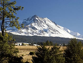
Chicnautécatl

Mexico’s fourth highest peak is an extinct volcano that rises elegantly above the city of Toluca. It is generally referred to as “el Nevado”, which is short for “el Volcán Nevado de Toluca”, Toluca’s Snow-Covered Volcano. Nowadays, however, the name is sadly inaccurate since the volcano is hardly ever covered in snow.

El Nevado is also known as Xinantécatl[1]. This name first appeared in an official registry in the second half of the nineteenth century. It sounds like Nahuatl, the language of the Aztecs, but historians have debated at length about its origin and meaning, questioning its authenticity. The closest place name that bears any etymological resemblance is the town of Zinacantepec, “Hill Where There Are Bats”. However, the volcano does not possess a significant bat population, and Zinacantepec is only one of dozens of small towns that surround it.

It is possible that the original name in Nahuatl had really been Chicnautécatl, “Nine Peaks”. This would dovetail nicely with the Lerma River’s old Nahuatl name of Chicnahuapan, “Nine Rivers”. The River Lerma is the result of the confluence of several streams that spring from the sides of the volcano.

An explanation offered by García Martínez of how “Chicnautécatl” could have become “Xinantécatl” is a not-so-farfetched series of errors, considering the lack of a basic alphabet in Nahuatl. It could all boil down to how the name was pronounced by one person, written down by a second, and later read and copied, or rather miscopied, by a third.

The number nine in nahuatl is “chicnaui” and that is how it is generally written now, but it can be pronounced “shicnaui” as well as “chicnaui”. It is possible that one person informed a second that the volcano was called “Chicnautécatl”, pronouncing it with a “sh” sound, and the one who listened wrote an “X” for the beginning “sh” sound (the Castilian alphabet has no letter for the “sh” sound). So, it may have been registered as “Xinautécatl”. Then, according to this line of thought, a third person misread the name, mistaking the “u” for an “n”, or miscopied it, writing an “n” instead of the “u”, thus giving rise to “Xinantécatl”.

However it may have been, the volcano is still more often referred to as “el Nevado”.

Fortunately, the origins of most place names in Mexico are more straightforward and comprehensible. The next part of this article examines why many Mexican place names have up to four distinct layers of meaning.


[1] In Mexican Spanish, the “x” can be pronounced “s” as in sun, “sh” as in shoe, “h” as in hat, or “x” as in taxi. In the case of “Xinantécatl” it is pronounced “s”.

Click on the word “placenames” or the “placenames” tag for more articles about Mexico’s place names.

“La Curva de la Gringa”, the American woman’s curve, a place name in Michoacán, Mexico

 Maps, Mexico's geography in the Press, Other  Comments Off on “La Curva de la Gringa”, the American woman’s curve, a place name in Michoacán, Mexico
Mar 302010
 

Another interesting example of an unusual place name (following on from an earlier post about unusual place names) is the name “La Curva de la Gringa”, the American woman’s curve.

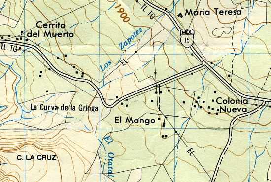
La Curva de la Gringa is the name of a 90-degree bend near Jungapeo, west of Zitácuaro in the state of Michoacán. Literally translated as “the American woman’s curve”, how did this name come about? The first thing to remember is that all names on maps have to come from somewhere. Detailed maps of Mexico, including the 1:50,000 series, relied initially on aerial (later satellite) imagery, followed by some checking on the ground. Given the expense, ground checking was often relatively limited. However, the on-the-ground surveyors were responsible for adding names to the maps.

La Curva de la Gringa, Michoacán (on Mexico’s 1:50,000 topographic map)

In this case, local informants were apparently unanimous in calling this bend La Curva de la Gringa. Further research shows that this had nothing to do with any purported similarity to the sensuous curve of a gringa‘s breast, but derived from when the road was first paved in the 1950s. Apparently, shortly after the road was finished, an American lady driving her oversized gas-guzzler down to the luxury spa of San José Purua completely missed this bend, and plowed into a cornfield. The locals have long memories!

In 2010, this road is being widened, and sidewalks and street lights installed, all the way from Federal Highway 15 (see map), past La Curva de la Gringa, and as far as the money allocated (currently about 7 million pesos) allows. The first section was due to be inaugurated 21 March 2010. If anyone has an update, please leave a comment. Here’s hoping that no more accidents ever occur along this stretch of road, and that no future place names ever reflect such unfortunate incidents.

Mar 162010
 

In earlier posts, we’ve taken a quick look at typical Spanish-language place names (toponyms) and also some common indigenous place name elements. But what about those place names that do not match any of the expected categories?

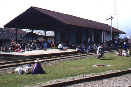
Honey Railway Station (dating from 1908)

My personal favorites in this category include the railway stations of Honey in the state of Puebla (named for a famous railroad engineer) and Wadley in the state of San Luis Potosí. The latter is particularly strange since the letter w does not belong to the Spanish alphabet. I’ve never been able to identify the origin of the name Wadley with any certainty, but for one possible explanation, see Mexico has many “Est”raordinary railway places.

Wadley Railway Station in San Luis Potosí

Another example of an unusual name is that given to one of the sharpest curves on the Mexico City to Cuernavaca highway — La Curva de la Pera, which means “The Curve of the Pear”. The derivation of this name for a bend in the road that loops back on itself is fairly self-evident. Here’s hoping that your vacation after navigating past this bend does not end up being similarly “pear-shaped”!

Many similar instances of how names were allocated, and examples where place names proved critical to legal issues, are given in Raymond Craib’s excellent “Cartographic Mexico, a history of state fixations and fugitive landscapes” (Duke University Press, 2004). This is a perceptive study of the relationships between history and geography in Mexico from the mid-19th century until about 1930. Craib emphasizes the significance of map-making in post-Independent Mexico as a means towards furthering nationalism and as a development tool. He also traces the changing motives of map-makers, focusing especially on the key area of Veracruz-Puebla which served as Mexico’s main gateway to Europe for centuries. One case study examines a mining area where the granting of water rights hinged on precisely where a particular river flowed, and which tributary was which. This proved to be a case where cartographic ‘proof’ was impossible to find, and a pragmatic solution was required.

For a more complete explanation of some of Mexico’s place names, see “Mexico’s place names and their meanings” on MexConnect.

Mexico’s Spanish language place names

 Teaching ideas  Comments Off on Mexico’s Spanish language place names
Feb 182010
 

The Spanish language is at least as rich as English when describing landscapes. Common Spanish geographical terms relating to landscape include:

  • cerro = hill
  • montaña = mountain
  • sierra = elongated mountain range
  • mesa = flat-topped (table) hill
  • cumbre = summit or peak
  • pico = sharp peak
  • valle = valley
  • barranca = canyon
  • cenote = limestone sinkhole
  • cabo = point or cape
  • punta = point or headland
  • arroyo = brook
  • río = river
  • lago = lake
  • salto, cascada = waterfall
  • ojo (de agua) = spring
  • presa = reservoir (and dam)
  • mar = sea
  • salinas = salt flats or salt works
  • golfo = gulf
  • bahía = bay
  • puerto = port (inland, puerto = pass)

[Extract from chapter 1 of Geo-Mexico: the geography and dynamics of modern Mexico]

Mexico’s indigenous place names

 Teaching ideas  Comments Off on Mexico’s indigenous place names
Feb 172010
 

Mexico’s place names, or toponyms, offer many clues about geography. Mexico’s indigenous peoples spoke languages that had no formal alphabet. For place names, they used combinations of pictographs, ideographs and phonetic symbols.

Spanish explorers recorded the names provided by the locals as best they could, resulting in some inevitable confusion and distortion. For instance, it is sometimes claimed that “Yucatán” actually derives from Maya Indians responding, “I don’t know!” when asked to name a nearby place.

Suffixes derived from indigenous (mostly Nahuatl) words include:

  • -apan = in/near water or river
  • -calco = in the house of
  • -can = place
  • -cingo, -tzingo = (small) place of settlement
  • – huacan, -oacan = place where they have
  • -pan = in/on
  • -ro = place
  • -tepec = hill
  • -tepetl = mountain
  • -titlan = near
  • -tla = abundance
  • -tlan = in or near

Can you think of examples of modern-day place names using each of these suffixes? For instance,  “Zapopan”, in the state of Jalisco, is an example of a place name ending in -pan = in/on.

[Edited extract from chapter 1 of Geo-Mexico: the geography and dynamics of modern Mexico]

The Aztecs knew their geography!

 Other  Comments Off on The Aztecs knew their geography!
Feb 122010
 

Aztec place glyphs drawn in the 16th century Codex Mendoza suggest that the Aztecs had all the major branches of geography covered.

Physical geography

Poctépec = hill that smokes (volcano)

Human geography

Teocalcingo = where the temple is

Economic geography


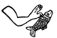
Michmaloyan = place to fish

The Aztecs clearly knew their geography!

[Extract from chapter 1 of Geo-Mexico: the geography and dynamics of modern Mexico]