May 032011
 

Somewhat surprisingly, the number of Mexicans speaking indigenous languages has increased significantly in the past 20 years. In 2010 there were 6.7 million indigenous speakers over age five compared to 6.0 million in 2000 and 5.3 million in 1990.

There are two factors contributing to this finding:

  • First, indigenous speakers are teaching their children to speak their indigenous language.
  • Second, indigenous speakers have higher than average birth rates.

The number of indigenous speakers that cannot speak Spanish decreased slightly from 1.0 million in 2000 to 981,000 in 2010.

The most widely spoken indigenous languages are:

  • Nahuatl, with 1,587,884 million speakers, followed by
  • Maya (796,405),
  • Mixteca (494,454),
  • Tzeltal (474,298).
  • Zapotec (460,683), and
  • Tzotzil (429,168).

[Note: language names used here include all minor variants of the particular language]

About 62% of all indigenous language speakers live in rural areas, communities with under 2,500 inhabitants. Nearly 20% live in small towns between 2,500 and 15,000, while about 7% in larger towns, and 11% live in cities of over 100,000 population. Indigenous speaking areas tent to have low levels of development. Over 73% of the population In Mexico’s 125 least developed municipalities speak an indigenous language.

States with the most indigenous speakers tend to be in the south. In Oaxaca, almost 34% of the population over age three speak an indigenous language followed by Yucatán (30%), Chiapas (27%), Quintana Roo (16%) and Guerrero and Hidalgo (15%). States with the fewest indigenous speakers are Aguascalientes and Coahuila (0.2%), Guanajuato 90.53%) and Zacatecas (0.4%).

A total of 15.7 million Mexicans over age three consider themselves indigenous. Surprisingly, 9.1 million of these cannot speak any indigenous language. There are 400,000 Mexicans who can speak an indigenous language, but do not consider themselves indigenous.

Related posts:

Chapter 10 of Geo-Mexico: the geography and dynamics of modern Mexico is devoted to Mexico’s indigenous peoples. Many other chapters of Geo-Mexico include significant discussion of the cultural and development issues facing Mexico’s indigenous groups.
Are women better than men at gathering mushrooms on the slopes of a Mexican volcano?

 Other  Comments Off on Are women better than men at gathering mushrooms on the slopes of a Mexican volcano?
Apr 122011
 

This post summarizes the findings of an article entitled “Sex differences in mushroom gathering: men expend more energy to obtain equivalent benefits”, published in the July 2010 issue of Evolution & Human Behavior.

Men are often thought to have superior spatial abilities to women. However, recent research has suggested that such differences are task dependent. It is now commonly argued that differences in spatial abilities may date back to early human societies during the Pleistocene. At that time, men’s spatial skills became fine-tuned for successful hunting of animals that were constantly on the move, while women’s spatial skill-set developed to ensure success in gathering immobile plant resources.

In a nutshell, men are thought to find their way about using orientation, and women by memorizing landmarks. One study reported that men performed better than women in finding their way through unfamiliar woodland, whereas another study showed how women exploring a farmers market in Santa Barbara, California, could remember where individual food items were more accurately than men.

Despite these earlier studies, the male/female differences in spatial skills had never been tested in appropriate circumstances in the field prior to the research carried out by four enterprising Mexican researchers led by Luis Pacheco-Cabos of the National University (UNAM).

The setting

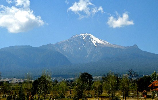
The team studied the foraging techniques and success rate of men and women from a small village in Tlaxcala as they searched for edible mushrooms on the slopes of La Malinche volcano (Malintzin).

The small rural community of San Isidro Buensuceso has about 8,000 Nᨵatl-speaking inhabitants. The villagers have a long history of collecting mushrooms. Most mushroom collecting takes place during the summer rainy season. The vegetation in collecting areas is relatively open pine-oak forest, though the precise mix of species varies with altitude.

La Malinche Volcano

La Malinche Volcano

Each small group of mushroom collectors was followed by a researcher who recorded their movements and the weight of mushrooms collected. The exercise was carried out at seven different sites, most more than 3000m above sea level, through relatively open forest in terrain that included steep gullies carved into the flanks of volcano. The researchers were continuously monitored to record data enabling the calculation of the energy they expended in kilo-calories (kcal). Collectors gathered up to 9.5 kg of mushrooms in a single trip.

What were the teams key findings?

Although men and women collected similar quantities of mushrooms, men did so at significantly higher cost. They traveled further, to greater altitudes, and had higher mean heart rates and energy expenditure (kcal). They also collected fewer species and visited fewer collection sites.

Women used their superior powers of memorizing object location to collect more species, and visit more collection sites than men, obtaining more mushrooms during the same period of time, with less energy expenditure.

What does this mean?

The results suggest that differences in spatial ability between men and women are task-dependent. In terms of search strategies developed for gathering wild mushrooms, and presumably other wild plants, women outperform men. The women proved to be more efficient foragers than men in energy efficiency terms since they collected significantly more mushrooms while expending significantly less energy in doing so.

The researchers did not publish any calculation for the energy efficiency of mushroom collectors for comparison with the figures quoted in: The energy efficiency of farming in Mexico and elsewhere. However, based on their data, and assuming that 3 grams of raw mushrooms are approximately equivalent to 1 calorie, the energy efficiency for mushroom pickers on the slopes of La Malinche volcano must be somewhere between 0.5 and 1.7, with men tending towards the lower value. An energy efficiency of 1.0 would mean that the energy expended in gathering mushrooms is roughly the same as the calorific energy they contain.

The researchers conclude that similar studies are now needed for other cultural groups, and for the gathering of different resources, such as firewood.

Source:

Luis Pacheco Cobos, Marcos Rosetti, Cecilia Cuatianquiz, Robyn Hudson: “Sex differences in mushroom gathering: men expend more energy to obtain equivalent benefits”, Evolution & Human Behavior, July 2010 (Vol. 31, Issue 4, Pages 289-297).

Geography research in Oaxaca funded by the US military stirred up a storm of protest

 Other, Teaching ideas  Comments Off on Geography research in Oaxaca funded by the US military stirred up a storm of protest
Feb 282011
 

In 2005, a geography research project known as México Indígena, based at the University of Kansas, received 500,000 dollars in funding from the US Defence Department to map indigenous villages in two remote parts of Mexico, in collaboration with the Autonomous University of San Luis Potosí , Radiance Technologies (USA), SEMARNAT (Mexico’s federal environmental secretariat) and partnered with the US Foreign Military Studies Office (FMSO).

Under some circumstances, this might not be a huge problem. After all, the large-scale survey maps of many countries were developed primarily by military engineers with military funding, in the interests of national security. In the past, several countries, including France and the UK, extended their map-making to cover their colonies or dependent territories.

What sets México Indígena apart is that, between 2005 and 2008, under the guise of “community participatory mapping”, US researchers, funded by the US military, collected detailed topographic, economic and land tenure information for several villages in Mexico, an autonomous nation, whose people have long viewed their northern neighbors with considerable suspicion. After all, in the mid-19th century, the USA gained a large portion of Mexico’s territory.

The indigenous villages mapped were in the Huasteca region of San Luis Potosí, and in the Zapotec highlands of Oaxaca, the most culturally diverse state in Mexico. The villages mapped in Oaxaca included San Juan Yagila and San Miguel Tiltepec.

México Indígena is part of a larger mapping project, the Bowman Expeditions. In the words of the México Indígena website:

“The First Bowman Expedition of the American Geographical Society (AGS) was developed in Mexico…  The AGS Bowman Expeditions Program is based on the belief that geographical understanding is essential for maintaining peace, resolving conflicts, and providing humanitarian assistance worldwide.”

“The prototype project in Mexico is producing a multi-scale GIS database and digital regional geography, using participatory research mapping (PRM) and GIS, aiming at developing a digital regional geography, or so-called “digital human terrain,” of indigenous peoples of the country.”

Mexico’s indigenous communities are the poorest in the country, beset by poverty, poor access to education and health care, and limited economic opportunities. Among the common concerns voiced by protesters against the mapping project were that the information collected could be used for:

  1. Counter-insurgency operations
  2. Identification and subsequent acquisition of resources
  3. Biopiracy

Despite attempts at clarification by the project leaders, some communities remain upset, claiming that they were not made aware of the US military’s funding, and have demanded that all research findings either be returned to the community or destroyed (see, for example, this open letter from community leaders in San Miguel Tiltepec).

Choose the conclusion you prefer:

1. Mexico’s indigenous peoples face enough challenges already. Their best way forward is if US military funding for mapping beats a hasty retreat, or

2. Mexico’s indigenous peoples face enough challenges already. Their best way forward is to welcome and embrace offers of help from outside their community.

Further reading/viewing:

The México Indígena controversy is the subject of a short film entitled, “The Demarest Factor: US Military Mapping of Indigenous Communities in Oaxaca, Mexico”. The film investigates the role of Lt. Col. Geoffrey B. Demarest ( a US Army School of the America’s graduate) and the true nature of the mapping project. It discusses parallels between US political and economic interests within the North American Free Trade Agreement (NAFTA) and a US military strategy designed to secure those very interests.

Things to think about:

  • Should academic research in foreign countries ever be funded from military sources?
  • Does the right of self-determination mean that indigenous peoples can refuse to cooperate with academic researchers, even when the research may bring benefits to the community?
  • Should researchers ever be allowed to collect information from a community without the community’s express consent?

The irony about the choice of “Bowman” for the AGS research expeditions.

Isaiah Bowman (1878-1950), born in Canada, was a US geographer who taught at Yale from 1905 to 1915. He became Director of the AGS in 1916, a position he only relinquished when appointed president of Johns Hopkins University in 1935. He served as President Woodrow Wilson’s chief territorial adviser at the Versailles conference in 1919. Bowman’s best known work is “The New World: Problems in Political Geography” (1921). His career has been subject to considerable scrutiny by a number of geographers including Geoffrey Martin (The life and thought of Isaiah Bowman, published in 1980) and Neil Smith who, in American Empire: Roosevelt’s Geographer and the Prelude to Globalization (2003) labels Bowman an imperialist, precisely the claim made by many of its opponents about the México Indígena mapping project.

Sep 152010
 

The remote Copper Canyon region in northern Mexico is the home of 50,000 Tarahumara Indians who have preserved much of their distinctive culture (language, dress, customs, beliefs) into this century, partly because of their extreme remoteness. Many live untouched by the trappings of modern civilization, moving between caves just below the canyon rim and warmer, winter shelters at lower altitude near the Urique River.

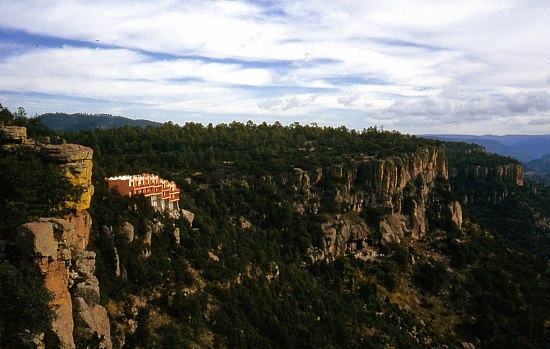
Modern hotels are encroaching on the Copper Canyon

Modern hotels are encroaching on the Copper Canyon, and changing the views in this wilderness region. Photo: Tony Burton; all rights reserved.

Their radically different lifestyle and extreme isolation beg many questions. Their ancestral homelands are already being invaded by marijuana-growers and trampled on by outside developers who have very different notions of property rights and very different customs.

Questions to think about:

  • Are the Tarahumara Indians really in any position to make informed decisions about their future?
  • Should we leave them entirely alone and let them decide entirely for themselves?
  • Should we offer education about what we would consider the benefits of the modern world?
  • Should we improve their access to health services and hospitals?
  • Should we encourage them to acquire computers and internet access?
  • Might these progressive elements destroy their existing lifestyle, break down their social and political structures and ultimately wipe them out?
  • What do YOU think? Now, imagine you were a Tarahumara Indian – would you think the same?
  • Who should decide the future of this region?

Previous Geo-Mexico posts related to the Copper Canyon:

Chapter 10 of Geo-Mexico: the geography and dynamics of modern Mexico is devoted to Mexico’s indigenous peoples, including the Tarahumara Indians. If you have enjoyed this post, please suggest to your local library that they purchase a copy to enhance their collection.

Cultural and eco-tourism in the Copper Canyon region of Mexico

 Other, Teaching ideas  Comments Off on Cultural and eco-tourism in the Copper Canyon region of Mexico
Sep 102010
 

The Copper Canyon area is one of Mexico’s most popular destinations for eco-tourism activities. The canyons offer plenty of opportunities for canyoneering (like mountaineering, but starting from the top!), wilderness hikes and adventure trips. Mexico’s two highest waterfalls—Piedra Volada and Baseaseachi— are also in this area. The Basaseachic Falls are about 250 meters (820 ft) in height, beaten only by the virtually inaccessible 453-meter-high Piedra Volada falls, also in the state of Chihuahua. The Basaseachic National Park is easily accessible via paved roads from Chihuahua City.

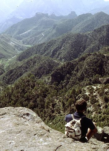
Magnificent scenery attracts hikers from all over the world.

Magnificent scenery attracts hikers from all over the world. Photo: Tony Burton; all rights reserved.

Adding to the allure of the Copper Canyon region is the fact that it is the home of some 50,000 indigenous Tarahumara Indians with their distinctive language, customs and lifestyle. The Tarahumara are one of the most culturally distinct groups in all of Mexico, famous especially for their long distance running ability and communal spirit.

Relatively easy access to this region is possible because of the railway line which runs from Chihuahua City to the lumber town of Creel, close to the canyons, and then skirts the canyon rim before descending to El Fuerte (once the capital of Arizona) and Los Mochis in Sinaloa. This railway is an incredible feat of engineering brilliance, matched by few railway lines anywhere on the planet. The railway is the lifeline of this remote region.

Travel articles:

Tourism in this area is not without its discussion points. Tourists place more pressure on scarce resources such as potable water. As noted in an earlier post, tourism has led to changes in the items made by indigenous Tarahumara women. Some hotel developers have viewed the Tarahumara as a human resource to be exploited as a quaint experience for their clients, though others have quite rightly viewed the Tarahumara as the area’s most important assets, one to admire and appreciate for what they are and how they have adapted to the harsh environment in which they live.

Points to ponder (discussion topics in class):

  • Should tourists encourage a monetary economy by buying Tarahumara souvenirs?
  • Is there a risk of tourists introducing a disease to which the Tarahumara have no resistance?
  • Should tourists be allowed to pick flowers and collect souvenir rock samples in the Copper Canyon area?
  • What are the pros and cons of tourists giving small items such as T-shirts to the Tarahumara?
  • What items, if any, are appropriate for tourists to offer the Tarahumara if they wish to give them something for sharing their ancestral homeland?
  • Is it right to take photos of Tarahumara homes, such as their cave dwellings?

Previous Geo-Mexico posts related to the Copper Canyon:

Chapter 10 of Geo-Mexico: the geography and dynamics of modern Mexico is devoted to Mexico’s indigenous peoples, including the Tarahumara Indians. If you have enjoyed this post, please suggest to your local library that they purchase a copy to enhance their collection.

Sep 092010
 

In two previous posts, we examined the historical connections between Mexico and the Philippines.

A news story (on mb.com.ph) a few months ago alerted us to another, much more recent link between the two countries.

The Philippine Drug Enforcement Agency (PDEA) claims that a Mexican herb poses a significant public health risk. According to the PDEA, Salvia divinorum, which is hallucinogenic when sun-dried leaves are chewed, sniffed or smoked, has been found growing wild in the Teachers Village in Quezon City. The plant is a member of the mint family and has a distinctive square stem. It is not known how or when it was introduced into the Philippines.

It is endemic to the remote region of the Sierra Mazateca in the northern part of the state of Oaxaca, Mexico. The plant grows in the warm, damp tropical evergreen and cloud forests at elevations between 300 and 1800 meters (1000 to 6000 feet). Biologists remain uncertain whether the plant is a truly natural plant or whether it is actually a hybrid (a cross between two or more distinct plant species) or cultigen (a plant that has been deliberately altered or selected by humans). It is commonly known in Mexico as divine sage, and the local Mazatec indigenous group has a long tradition of employing the plant in spiritual healing ceremonies.

The active constituent of Salvia divinorum is known as salvinorin A. Wikipedia’s entry on divine sage claims that “By mass, salvinorin A is the most potent naturally-occurring psychoactive compound known.”

We are not sure why it is in the interests of the PDEA to offer helpful tips for anyone thinking of growing and using this particular plant, but a PDEA spokesperson did just that, describing the plant as being somewhat similar to cannabis (marijuana), but easier to grow, since it can be propagated via stem cuttings. In addition, “The addictive effect of the said plant will last long if the leaves of the plant will be spread on a person’s gums rather than sniffing or puffing it like a cigarette. They say it gives you an uncontrollable laugh trip because the user will see the people as if they were caricatures or cartoons.” At least the final part of that quote appears to be hearsay and probably not admissible if introduced into a courtroom!

Despite its known hallucinogenic qualities, the cultivation and possession of divine sage remain legal in almost every country around the world. In the USA, only certain states have criminalized the plant. Click here for a webpage which provides more details of divine sage’s legal situation in particular countries and US states.

In the Philippines, the PDEA is reported to be collecting further evidence prior to recommending whether or not owning the plant should be made illegal. Sounds like it could be a fun job if you can get it!

Divine sage is the latest link in the 450-year-long history of close connections between Mexico and the Philippines.

Mexico’s links with other countries are discussed in chapter 20 of Geo-Mexico: the geography and dynamics of modern Mexico. Ask your library to buy a copy of this handy reference guide to all aspects of Mexico’s geography today! Better yet, order your own copy…

Mexico’s Copper Canyon train is one of the world’s great railway trips

 Excerpts from Geo-Mexico, Other  Comments Off on Mexico’s Copper Canyon train is one of the world’s great railway trips
Sep 022010
 

The Copper Canyon region is one of the most remote parts of Mexico. This remoteness helps to explain why the area is the home of about 50,000 Tarahumara Indians, and how they have managed to preserve much of their highly distinctive culture to this day.

The Copper Canyon railroad line, “the most dramatic train ride in the Western Hemisphere” (Reader’s Digest), begins in Ojinaga and continues, via Chihuahua, to Los Mochis and Topolobampo. The railroad was started in the 1870s to enable produce grown in southern Texas to be exported via a Pacific port. Simultaneously, the twin settlements of Los Mochis and its port Topolobampo were developed on the other side of the Western Sierra Madre. The railroad project floundered and successive attempts to complete it all failed. Some innovative engineering finally led to the line being completed in 1961. Total cost? Over $100 million.

The highlights include a 360-degree loop at El Lazo (km 585 from Ojinaga), one of only three comparable examples anywhere in North America), and a 180-degree turn inside a tunnel near Temoris at km 708. The line crosses the Continental Divide three times, reaches a maximum height of 2400 m (at km 583) and skirts the rim of the Copper Canyon. Between Chihuahua and Los Mochis, there are 37 bridges (totaling 3.6 km) and 86 tunnels (totaling 17.2 km). Almost all passenger rail services in Mexico ended in the 1990s but daily services continue along this line, mainly for tourists.

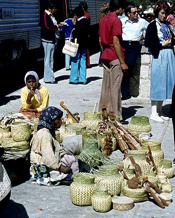
Tarahumara Indians wait for a sale at Divisadero, the station on the rim

Tarahumara Indians wait for a sale at Divisadero, the station on the canyon rim. Photo: Tony Burton; all rights reserved.

Almost all trains stop for a few minutes at Divisadero, a station set right on the rim of the canyon, with a lookout offering a magnificent panoramic view. Shy Tarahumara women and children sit quietly, weaving pine-needle baskets (see photo) and hoping for a sale. Many of them speak very little Spanish apart from the numbers; on the other hand, how many tourists speak even one word of the Tarahumara language? Thirty years ago, most articles sold by the women were items similar to ones they would use everyday themselves in their daily tasks. Sadly, many of the articles sold today are made specifically for the tourist trade.

Unlike the railway, Los Mochis and Topolobampo both soon flourished. Topolobampo was started by US engineer Albert Kimsey Owen who chose this previously unsettled area for a socialist colony based on sugar-cane production, and as the terminus for the railway. Topolobampo has one of Mexico’s finest natural harbors, a drowned river valley or ria, which affords a safe haven in the event of storms. Los Mochis was officially founded in 1893 by a second American, Benjamin Johnston, who built a sugar factory there.

Los Mochis became especially important in the second half of the twentieth century as a major commercial center, marketing much of the produce grown on the vast El Fuerte irrigation scheme. Much of this produce is still exported to the USA via the famous Copper Canyon railway. Los Mochis and Topolobampo are unusual—there are few other examples of such “new towns”, with no colonial or pre-Hispanic antecedents, anywhere else in Mexico.

Previous Geo-Mexico posts related to the Copper Canyon:

External links of interest:

Chapter 10 of Geo-Mexico: the geography and dynamics of modern Mexico is devoted to Mexico’s indigenous peoples, including the Tarahumara Indians. If you have enjoyed this post, please suggest to your local library that they purchase a copy to enhance their collection.

Mexico’s Copper Canyon is one of the world’s most amazing natural wonders

 Excerpts from Geo-Mexico, Updates to Geo-Mexico  Comments Off on Mexico’s Copper Canyon is one of the world’s most amazing natural wonders
Aug 282010
 

The Copper Canyon, one of Mexico’s most amazing natural wonders The rugged ranges of the Western Sierra Madre in the state of Chihuahua conceal several massive canyons, giving rise to incomparable scenery. The Copper Canyon (Cañon del Cobre) region is the collective name given to this branching network of canyons, larger in many respects (see table) than the USA’s Grand Canyon.

How does Mexico’s Copper Canyon compare to the US Grand Canyon?

Urique CanyonsUS Grand Canyon
Total length of rivers (km)540446
Depth (m)1250–18701480
Altitude of rim (m above sea level)2250–25402000–2760
Maximum width (km)415

Strictly speaking, the name Copper Canyon refers only to one small part of the extensive network of canyons which is more properly called by geographers the Urique Canyon system. As the table shows, the Urique Canyons are longer, deeper and narrower than their US rival.

Mexico's Copper Canyon

How was the Copper Canyon formed?

According to a local Tarahumara Indian legend, the canyons were formed when “a giant walked around and the ground cracked.” Geologists believe that a sequence of volcanic rocks varying in age from 30 to 135 million years were slowly uplifted to an average elevation of 2275 m (7500 ft) and then dissected by pre-existing rivers.

These antecedent rivers retained their courses, cutting down over 1400 m into the plateau surface, forming deep canyons and dividing the former continuous plateau into separate giant blocks. Centuries of erosion by the Urique river and its tributaries have resulted in the present-day landscape of structurally-guided plateau remnants, termed mesas, buttes and pinnacles, depending on their size.

Oaxaca is the most culturally diverse state in Mexico

 Excerpts from Geo-Mexico, Maps  Comments Off on Oaxaca is the most culturally diverse state in Mexico
May 042010
 

The inter-census population count in Mexico in 2005 found that more than one million people in Oaxaca spoke at least one indigenous Indian language. Close behind came the state of Chiapas with about 950,000 indigenous language speakers.

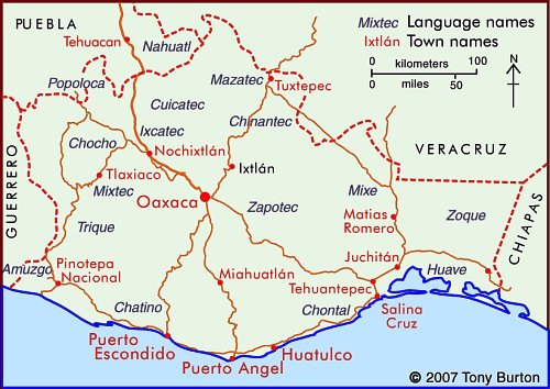
Indigenous Indian groups in the state of Oaxaca

In Oaxaca, according to the National Commission for the Development of Indigenous Peoples, more than 1.5 million people live in a home where at least one of the residents either speaks an indigenous language or considers themselves indigenous (even if they do not speak an indigenous language). This is 50% more people than are found in the same category in Chiapas.

Not only does Oaxaca have more indigenous people, it also has a much greater linguistic and cultural diversity than Chiapas or any other state in Mexico.

Oaxaca’s one million indigenous speakers represent 35% of the state’s total population. The largest indigenous linguistic groups in the state include about 350,000 Zapotec, 230,000 Mixtec, 165,000 Mazatec, 100,000 Chinantec, 100,000 Mixe, and 40,000 Chatino.

Almost 90% of Zapotec speakers also speak Spanish, which considerably enhances their education and employment opportunities. On the other hand, 23% of Mixtecs do not speak Spanish, and hence face a tougher challenge in the workplace. Tens of thousands of Mixtecs have migrated away from Oaxaca looking for work. Mixtec speakers tend to migrate to Mixtec-speaking neighborhoods; there are about 16,000 Mixtecs in Mexico City, 14,000 in Baja California, 13,000 in Sinaloa, and perhaps 50,000 in the USA. A sizable number of these migrants are essentially monolingual, with very limited Spanish.

The map shows the regions where the main indigenous groups in Oaxaca reside. One of the reasons for Oaxaca having retained such an extraordinary diversity of Indian groups is the state’s very rugged terrain, which has isolated numerous indigenous groups, cutting them off from mainstream Mexican society. This diversity of cultures helps to make Oaxaca one of Mexico’s most interesting states. The cultures find expression today not only in language, but also in modes of dress, handicrafts, music and dance. The state of Oaxaca celebrates its ethnic diversity in its annual extravaganza, the Guelaguetza festival, normally held in July.

Mexico’s cultural diversity is discussed in chapters 10 and 13 of Geo-Mexico: the geography and dynamics of modern Mexico.

This is an edited version of an article originally on MexConnect website.

Organic farming helps the Mam of Chiapas regain their cultural identity

 Books and resources  Comments Off on Organic farming helps the Mam of Chiapas regain their cultural identity
Apr 192010
 

The Mexican Mam (there are also Guatemalan Mam) first settled in Chiapas in the late nineteenth century, mainly in the deforested mountains of the eastern part of the state. They had virtually disappeared from view as a cultural group by 1970, having lost most of their traditional customs. Today, the 8,000 or so Mam, living close to the Guatemala border, have shown that it is possible for some indigenous groups to re-invent themselves, to secure a stronger foothold in the modern world.

Mexican policies from 1935-1950 towards Indian groups were focused on achieving acculturation, so that the groups would gradually assume a mestizo identity. It was widely held at the time that otherwise such isolated groups would inevitably be condemned to perpetual extreme poverty. To the Mam, this period is known as the “burning of the clothes”. Almost all of them lost their language, traditional dress, and methods of subsistence, and even their religion, in the process. Indeed, for a time, the term Mam never appeared in any government documents.

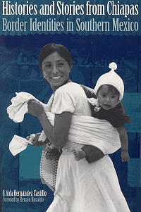
Cover of Histories and Stories bookFrom 1950-1970, the Mexican government opted for a modernization approach, building roads (including the Pan-American highway) and attempting to upgrade agricultural techniques. The mainstay of the regional economy is coffee. During this period, most Mam were peasant farmers, subsisting on corn and potatoes, gaining a meager income by working, at least seasonally, on coffee plantations. Working conditions were deplorable, likened in one report to “concentration camps”. Plantation owners forced many into indebtedness. The Mam refer to this period as the time of the “purple disease”: onchocercosis, spread by the so-called coffee mosquito. Untreated, it leads to depigmentation, turning the skin purple, skin lesions and blindness. Reaching epidemic proportions, it devastated the Mam peasants who had no access to adequate medical services.
After 1970, the Mam gradually re-found themselves, as official policy was to foment a multicultural nation. Some, especially many who had become Jehovah’s Witnesses, migrated northwards forming several small colonies, promoted by the government, in the Lacandon tropical rainforest on the border with Guatemala. Others, spurred on by Catholic clergy influenced by liberation theology, began agro-ecological initiatives.

For instance, one 1900-member cooperative, ISMAM (Indigenous People of the Motozintla Sierra Madre), specialized in the production of organic coffee. ISMAM’s agro-ecological initiatives benefited from the advice of the community’s elders and rescued many former sound agricultural practices, such as planting corn and beans alongside the coffee bushes to avoid the degradation that can result from monoculture. It halted the application of agrochemicals, and studied methods of organic agriculture and land restoration. Its coffee, adroitly marketed, commands premium prices, double those of regular coffee sold on the New York market. The Mam have effectively taken advantage of modern technology, from phones to e-mail, to overcome their isolation, and compete on their own terms, developing export markets in many European nations, as well as the U.S. and Japan.

At the same time, the Mam have re-invented their cultural identity and helped revive the language and traditional forms of dance. They have also rewritten their past. The revisionist version is that they always had the utmost respect for nature and had always lived in harmony with the environment. In reality, as historical geographers have demonstrated, this was not always the case. Whatever the historical reality, the defense of the earth, nature and their culture is now central to the Mam.

The main source for this post is R. Aída Hernández Castillo’s Histories and Stories from Chiapas. Border Identities in Southern Mexico (University of Texas Press, 2001).

Link to original article on MexConnect

An overview of Mexico’s indigenous peoples

 Other  Comments Off on An overview of Mexico’s indigenous peoples
Apr 162010
 

How many indigenous people are there?

According to INEGI figures, about six million Mexicans over the age of five speak at least one indigenous language. Another three million Mexicans consider themselves indigenous but no longer speak any indigenous language.

How many indigenous towns or villages exist?

INEGI figures show that, in over 13,000 localities, more than 70% of the population speaks an indigenous language. Most of these localities are small rural settlements with fewer than 500 inhabitants. These settlements are often highly marginalized, with high levels of poverty.

Speaking an Indian language is associated with disadvantage

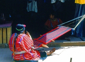
Oaxacan weaver. Photo: Tony Burton. All rights reserved

Speakers of indigenous languages fall way below the Mexican average on almost any socio-economic indicator. For instance, almost 33% of indigenous-speakers are illiterate, compared to a national rate of 9.5%. Females are particularly disadvantaged – indigenous females stay in school a full year less than their male counterparts, and for only half the time that the average non-indigenous female does. Even today, almost 5% of indigenous infants die before reaching their first birthday. A third of indigenous houses lack electricity; more than half do not have piped water.

Where do the indigenous people live?

More than 92% of the indigenous population lives in central and southern Mexico. With the notable exception of the 50,000+ Tarahumara Indians who live in the remote Copper Canyon region of Chihuahua, other indigenous groups in northern Mexico have relatively small populations.

The reason is largely historical. The major pre-Columbian civilizations in Mexico—Maya, Aztec, Zapotec, etc—developed in central or southern Mexico. The north always had fewer indigenous people. The disparity in numbers between north and south was heightened in early colonial times, as Spain expanded its territorial interests in New Spain along two major axes of economic development: the Mexico City-Veracruz corridor (the major trade route linking the capital to the port and Europe) and the Mexico City-Zacatecas corridor (the major route linking the capital to valuable agricultural and mining areas). It is no coincidence that indigenous languages and customs first died out along these corridors, as the indigenous people were forced to become assimilated into the developing dominant culture.

Indigenous peoples and languages did much better in the south. At last count, Oaxaca has over one million indigenous speakers representing more than a third of the state’s population. The state’s largest indigenous linguistic groups are the Zapotec, Mixtec, Mazatec, Chinantec, and Mixe. Oaxaca’s ethnic diversity is celebrated in the annual Guelaguetza festival, normally held in July.

Chiapas has almost as many indigenous speakers as Oaxaca. The largest indigenous groups in Chiapas are the Tzotzil, Tzeltal and Chol. One numerically-small Chiapas group is the Mam. Its recent history is an interesting study in how an indigenous group can re-invent itself in order to survive in the modern world.

The population figures quoted in this post are from INEGI’s Census and II Conteo de Población y Vivienda 2005 (INEGI, Aguascalientes).

Click here for original article on MexConnect

Chapter 10 of Geo-Mexico: the geography and dynamics of modern Mexico is devoted to Mexico’s indigenous peoples. Many other chapters of Geo-Mexico include significant discussion of the characteristics of, and development issues facing, Mexico’s many indigenous peoples.