Mar 242010
 

Update: New Durango-Mazatlán highway officially open (Oct 2013)

Update [October 2012]: Despite earlier claims that the Durango-Mazatlán highway would be completed before the end of 2012, government officials have now confirmed that the highway will not be finished, and will not open, until sometime in 2013.

Update [5 January 2012]:

Original post:

A truly amazing feat of engineering brilliance will force the authors of Geo-Mexico to revise one of their many original maps, when preparing the book’s next edition!

Figure 17.4 of Geo-Mexico is a map using isolines to show the average driving times by road from the city of Durango to everywhere else in Mexico. The map shows that it currently takes about five hours to drive the 312 km from Durango to the Pacific coast resort of Mazatlán, whereas driving south-east for five hours can take you as far as Encarnación de Díaz, 460 km away. The reason for this difference is that the rugged mountains of the Western Sierra Madre separate Durango from Mazatlán, whereas no significant relief obstacles lie between Durango and Encarnación de Díaz.

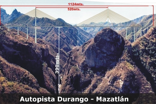
However, this pattern will change significantly once a new 1.2-billion-dollar highway between Durango and Mazatlán is complete. The four-lane, 230-kilometer-long highway is already well advanced; it will greatly reduce the travel time between the two cities. The major ‘missing piece’ remaining to be finished is the Puente Baluarte Bicentenario (Baluarte Bicentennial Bridge).

Puente Baluarte Bicentenario. Photo: TRADECO

This will be the biggest cable-stayed bridge ever built in Latin America. It is 1.124 km long and 4 lanes wide. Its central span extends 520 meters. At its highest point, it is a gravity-defying 390 metres (1280 feet) above the River Baluarte from which it takes its name. The bridge’s largest supporting pillar is 153 meters high, with a base measuring 18 meters by 30 meters.

Construction, by Mexican firm TRADECO, has required 103,000 tons of cement and almost 17,000 tons of steel. The bridge joins the states of Durango and Sinaloa and removes the need for drivers to negotiate a very dangerous stretch of highway known as the Devil’s Backbone.

Meanwhile, the authors of Geo-Mexico are busy preparing a map to show the next best example in Mexico where extreme differences of terrain influence travel times between major cities! Hopefully, the government won’t immediately use the new map in the next edition of Geo-Mexico to decide where to build their next major highway!

Mar 162010
 

In earlier posts, we’ve taken a quick look at typical Spanish-language place names (toponyms) and also some common indigenous place name elements. But what about those place names that do not match any of the expected categories?

Honey Railway Station (dating from 1908)

My personal favorites in this category include the railway stations of Honey in the state of Puebla (named for a famous railroad engineer) and Wadley in the state of San Luis Potosí. The latter is particularly strange since the letter w does not belong to the Spanish alphabet. I’ve never been able to identify the origin of the name Wadley with any certainty, but for one possible explanation, see Mexico has many “Est”raordinary railway places.

Wadley Railway Station in San Luis Potosí

Another example of an unusual name is that given to one of the sharpest curves on the Mexico City to Cuernavaca highway — La Curva de la Pera, which means “The Curve of the Pear”. The derivation of this name for a bend in the road that loops back on itself is fairly self-evident. Here’s hoping that your vacation after navigating past this bend does not end up being similarly “pear-shaped”!

Many similar instances of how names were allocated, and examples where place names proved critical to legal issues, are given in Raymond Craib’s excellent “Cartographic Mexico, a history of state fixations and fugitive landscapes” (Duke University Press, 2004). This is a perceptive study of the relationships between history and geography in Mexico from the mid-19th century until about 1930. Craib emphasizes the significance of map-making in post-Independent Mexico as a means towards furthering nationalism and as a development tool. He also traces the changing motives of map-makers, focusing especially on the key area of Veracruz-Puebla which served as Mexico’s main gateway to Europe for centuries. One case study examines a mining area where the granting of water rights hinged on precisely where a particular river flowed, and which tributary was which. This proved to be a case where cartographic ‘proof’ was impossible to find, and a pragmatic solution was required.

For a more complete explanation of some of Mexico’s place names, see “Mexico’s place names and their meanings” on MexConnect.

First map of Mexico on postage stamp

 Maps, Other  Comments Off on First map of Mexico on postage stamp
Mar 142010
 

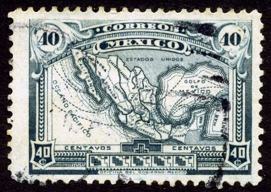
It was not until 1915, in the middle of the Mexican Revolution, that a map of the Republic appeared for the first time as the central design on a Mexican postage stamp.

Most states were named, though abbreviations were necessary given the size of the stamp. In 1915, though, the state of Nayarit on the Pacific Coast, north-west of Colima did not yet exist. It came into being in1917, with the signing of Mexico’s Constitution (the one which is still currently in force). Baja California, shown as single entity on the map, was divided into northern and southern sections in 1931.

In addition to the states, the map shows the main railway lines and also the main shipping routes. In 1915, the easiest way to reach the Yucatán Peninsula was by boat. It would be another 35 years or so before a rail link was completed between Veracuz and Merida. International shipping routes were very important in 1915, since air travel was in its infancy.

The map take some artistic license with scale. In particular, the island of Cuba has been brought much closer to the north-eastern tip of the Yucatán Peninsula than it really is.

The historical evolution of the boundaries of Mexico, and of its individual states, are analyzed in chapter 12, “The changing political map of Mexico” of Geo-Mexico: the geography and dynamics of modern Mexico. The development of Mexico”s railway lines is discussed in detail in chapter 17.

Mar 102010
 

As mentioned in a previous post about tourist guidebooks, the introduction of railways into Mexico and the gradual expansion of the railway network encouraged the development of all kinds of social, industrial and tourist activities.

The Mexico City-Puebla line was completed in 1886 and went via the small town of Cuautla in the state of Morelos. Cuautla is about 25 kilometers south-east of Cuernavaca.

In Cuautla, the builders of the railway found a perfect location for the town’s new station, very close to the center. They station was constructed around the cloisters of an abandoned building, the former Dominican convent of San Diego, which dated back to 1657. Its ecclesiastical life ended some years before parts of it were incorporated into the railway station in 1881.

The 1899 edition of Reau Campbell’s famous Guide provides an idea of what visitors to Cuautla could expect when the train was in its heyday:

The train stops some minutes in Cuautla and there may be time for a walk through the little alameda, just outside of the station, where there are trees and flowers, a hotel where there are good wines, coffee and lunches to be had. As the approach to the station has been through a grove of tropical trees and gardens, so is its departure, and the train continues southward through the cane country to Yautepec…

A decade later, the British-born journalist William English Carson (1870-1940) spent four months in Mexico. Carson also visited Cuautla:

It is a quaint, old-fashioned place, with narrow, cobble-paved streets, and houses of the usual low, flat-roofed type. As I strolled about the town the next morning, I noticed some unusually amusing signs of Americanization. An enterprising barber, for example, displayed a big signboard with the English inscription, “Hygienic, non-cutting barber shop,” as a tempting inducement to tourists, and one or two other establishments displayed in their windows the interesting announcement, “American spoke here.”
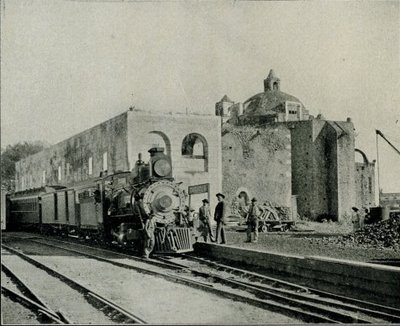
The Oldest Railway Station in the World. Cuautla. Inter-Oceanic Railway (from Carson).

Carson also describes the railway station:

Cuautla is also famous for having the oldest railway station in the world, the crumbling, ancient structure which is now used for this purpose having been the Church of San Diego built in 1657. … The day after my arrival I went into the old church, the body of which is now used as a warehouse, while one side of it bordering the railway line provides accommodation for the waiting-room and various offices. A quantity of wine-barrels were piled up at the spot where the high altar had formerly stood, and all kinds of merchandise were stored in other parts of the building. Over the door was an inscription, the first words of which seem appropriate enough to the present condition of the once sacred edifice: “Terribilis est iste hic domus dei et porta coeli ” (How dreadful is this place. This is none other but the house of God and this is the gate of heaven).

In October 1973, the original narrow gauge track from Mexico City to Cuautla was replaced with standard gauge line, bringing a premature end to the lives of several steam engines. These engines were among the very last steam locomotives used in regular service anywhere in North America. Fortunately, the oldest section of narrow gauge in Mexico, built between Amecameca and Cuautla still survives. Originally built in 1881 as the Ferrocarril Morelos (Morelos Railroad), it was partially re-opened, between Cuautla and Yecapiztla, for a tourist steam train service in July 1986, using engine #279 and four restored second class coaches. Engine 279 is a Baldwin locomotive, built in Philadelphia, first brought into service in 1904, and now spends most of its time resting contentedly in the Cuautla museum, the museum that is housed in the oldest building ever used as a railway station anywhere in the world.

Postscript: The rival claims of Red Hall, Bourne, U.K. to be the oldest station building in the world

I am very grateful to Tony Smedley and Ian Jolly, two very alert railway enthusiasts from the U.K., for bringing to my attention the rival claims of a railway station building in Lincolnshire to be the oldest in the world. The original owner of Red Hall, in Bourne, died in 1633. The Hall was later used as the Station Master’s house and Ticket office for the Bourne & Essendine Railway, which began operations in 1860. The last passenger train through Bourne station was apparently in 1959, with freight services ending a few years later. (For more details, click on Red Hall and Bourne Railway Station respectively.

Since the Red Hall (Bourne) station no longer has any rail tracks or trains associated with it, I stand by my claim (for now at least) that Cuautla station (which still does have rail tracks and trains) is the oldest railway station in the world. Apparently, Carson, at the time he was writing, was unaware of the rival claims of Red Hall.

Sources:

Campbell, Reau. Campbell’s New Revised Complete Guide and Descriptive Book of Mexico. Chicago. 1899.

Carson, William English. Mexico: the wonderland of the south. 1909

This is an edited version of an article originally published on MexConnect.
Click here for the complete article

The growth of the railway network and the importance of railways in Mexico are examined in depth in chapter 17 of Geo-Mexico: the geography and dynamics of modern Mexico and tourism in Mexico is the subject of chapter 19.
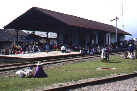
The development of railways led to tourist guide books

 Other  Comments Off on The development of railways led to tourist guide books
Mar 012010
 

In the golden age of steam, railway lines were built all over Mexico. Rail quickly became THE way to travel. Depending on your status and wealth, you could travel third class, second class or first class. Anyone desiring greater comfort and privacy could add their luxury carriage to a regular train. To avoid mixing with the ordinary folk, the super-rich and the privileged few hired or ran their own special trains.

The railway era ushered in an entire new genre of travel writing, which culminated in the first genuine guidebooks, describing routes and places that other travelers could visit with relative ease. The earliest comprehensive guide to Mexico was Appletons’ Guide to Mexico (1883); it was soon followed by several others including Campbell’s Complete guide and descriptive book of Mexico, first published in 1895.

The 1899 edition of Reau Campbell’s famous Guide provides an idea of what visitors to Cuautla in the state of Morelos, for example, could expect when the train was in its heyday:

Here again the tourist finds another feature of Mexico’s scenery and people, totally different from all the other travels in the Republic. The houses are adobe as to walls and thatched as to roofs; the broad plains have curious trees; bands of Indians troop from one town to another in curious costumes, marching along totally oblivious to the passing locomotive and approaching civilization, and will not give way to the latter any quicker than they will to the engine if they happen to be on the track when it comes along. In fact, it is hard for them to understand that the train cannot “keep to the right” when it meets people in the road, and they claim the right of way from the fact that they were there first.

A decade later, the British-born journalist William English Carson (1870-1940) spent four months in Mexico. Carson also visited Cuautla, on the advice of a doctor as the result of catching influenza.

Upon making inquiries at the railway office about trains to Cuautla, the clerk handed me an illustrated pamphlet with a fine colored picture on the cover representing a Mexican tropical scene. It bore the title, “Cuautla, Mexico’s Carlsbad.” What! I thought, another Carlsbad? In glowing language the booklet described Cuautla as an earthly paradise with a magnificent climate, beautiful scenery, splendidly equipped hotels and a warm sulphur spring whose waters were a certain specific for almost every human ailment. What more could one desire?

Carson continues:

Cuautla is about a hundred miles or so from Puebla, and the speedy trains of the Interoceanic Railway take about ten hours to make the journey. The train which I took left about seven o’clock in the morning ; it was not timed to reach Cuautla until five in the evening; and as there was not any restaurant at any intermediate station, a somewhat terrifying prospect of starvation faced travellers. How were they to get their luncheon? A little pamphlet given away by an American tourist agency and evidently written by an accomplished press-agent gave me the desired information: “At a certain station on the road,” said my traveller’s guide, “your train will stop for some twenty minutes. Here you will be greeted by graceful Indian women,— beauties, many of them, with their olive skins and dark, flashing eyes, bearing themselves with queenly grace in their dainty rebosos and flowing garments, white as the driven snow. They will offer you such dainties as tamales, chili-con-carne and tortillas, piping hot from their little stoves, and prepared with all the scrupulous cleanliness of a Parisian chef. They will bring you dainty refrescos of freshly gathered pineapple or orange to quench your thirst, and pastry such as your mother may have made when her cooking was at its prime.”
Now, what more could any reasonable traveller demand? What need was there for a restaurant when there were all these good things to be enjoyed? I showed my guide to an American friend before I started. He chuckled, gave a knowing wink and remarked, “Great is the faith of man, for after all your experiences you can still believe in a Mexican guide-book.”

Hotels were not always the same standard as those in the USA, but were certainly less expensive:

The attractions of the hotel were hardly up to those of a Carlsbad establishment, for it had neither a writing nor a smoking room; but the terms were rather more attractive than the usual Carlsbad tariff, being about two dollars a day inclusive. It is true there was a good deal of Mexican about the cooking, but the meals were not at all bad and the service very fair…

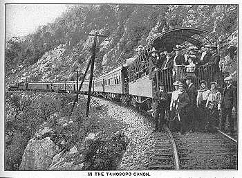
Railways may have opened up Mexico for tourism, but today, sadly, there are virtually no passenger lines still operating, the main exception being the justly famous Copper Canyon line from Los Mochis to Chihuahua.

Sources:
Campbell, Reau. Campbell’s New Revised Complete Guide and Descriptive Book of Mexico. Chicago. 1899.
Carson, William English. Mexico: the wonderland of the south. 1909

This is an edited version of an article originally published on MexConnect.
Click here for the complete article

The growth of the railway network and the importance of railways in Mexico are examined in depth in chapter 17, and tourism in Mexico is the subject of chapter 19. of  Geo-Mexico: the geography and dynamics of modern Mexico.