Are Mexico’s rural areas more diverse than its cities?

 Excerpts from Geo-Mexico  Comments Off on Are Mexico’s rural areas more diverse than its cities?
Jun 302011
 

Which are more diverse: Mexico’s rural areas, or its cities?

At first glance, Mexico’s rural areas are all quite similar in that they lack the characteristics of Mexico’s large cities such as tall buildings, traffic congestion, modern shopping malls, bustling streets, heavy industry and the like. While rural areas are all similar in that they lack urban characteristics, Mexico’s rural areas are actually quite diverse. But is there really more diversity among Mexico’s rural communities than its cities?

The physical form and architecture of cities are essentially independent from their surrounding natural environments. On the other hand, rural settlements tend to be integrated more closely with the natural environment. For example, villages in the arid central plateau tend to be constructed of locally available adobe, which keeps residents relatively cool during the hot afternoons and warm during the colder nights. In the tropical parts of Mexico, rural settlements tend to be built with locally available tropical materials which keep the rain out, but let air breezes through to mediate the hot tropical climate.

Rural settlements all tend to rely heavily on farming as the basic economic activity. The surrounding natural environment essentially dictates the type of farming that is practiced. Obviously, farmers in the central plateau cannot successfully grow bananas, sugarcane and other tropical products requiring lots of water. However, varieties of corn are grown virtually everywhere in Mexico.

The social characteristics of Mexico’s rural areas are also very diverse compared to the cities. In general Mexican cities are quite similar from a social perspective. Social customs and mores, as well as social classes, are relatively constant from one city to the next. Spanish is the overwhelmingly dominant language in the cities. Rural communities in various parts of the country often have different social mores and customs. Communication in some rural areas is largely, if not almost exclusively, in local indigenous languages:

The diversity of Mexico’s almost 200,000 rural localities should not be confused with the relative homogeneity within any given rural community.

In conclusion, while diversity between rural areas may be greater than that between cities, there is usually far more diversity within a Mexican city than within any given rural community.

Drug gangs diversify their business activities

 Mexico's geography in the Press  Comments Off on Drug gangs diversify their business activities
Jun 282011
 

Wise investors know that diversification is a sound way to protect their resources, and Mexico’s drug cartels have apparently been well educated in this regard. Recent news reports have highlighted two new ways in which Mexico’s drug cartels preserve and grow their wealth: the marketing of pirated merchandise, and the theft and sale of natural gas concentrates.

Marketing of pirated merchandise

According to an article originally published in the Dallas News, Mexico’s drug gangs now make almost as much money from pirated merchandise as from their trade in illicit drugs. By some estimates, the proliferation of pirated brand name goods has resulted in more than 450,000 manufacturing job losses and has caused the demise of many textile, clothing and shoe-making firms. Officials say that pirated videos account for as many as 9 out of every 10 movies sold across the country.

Pirated videos

"Almost original" DVDs for sale in Mexico

Theft of natural gas concentrates

Mexico’s giant Burgos natural gas field, which straddles the northern states of Tamaulipas, Nuevo León and Coahuila, lies in a zone which has become a center for violence in Mexico’s drug wars. Pemex, Mexico’s state-owned oil giant, claims that up to 40% of the gas concentrate produced has been stolen since 2006, as drug gangs have systematically targeted, kidnapped and intimidated oil workers. In some cases, cartels have even constructed their own pipelines to siphon off the gas, before filling their own tankers and driving them across the border using forged documentation.

Pemex has filed suit in Texas against eleven US firms (including Plains All American Pipeline LP, SemCrude, and Western Refining), alleging that they purchased up to 300 million dollars of fuel illegally acquired by drug gangs from Mexican pipelines and then shipped across the border. According to Pemex lawyers, the US firms may have been complicit in the forging of documents required for the gas concentrate shipments to cross the border, and profited (knowingly or unwittingly) from the trafficking of stolen fuel.

Previous posts about the geography of drug trafficking and drug cartels in Mexico:

Geo-Mexico: the geography and dynamics of modern Mexico discusses drug trafficking in several chapters. A text box on page 148 looks at trends in the drug trafficking business and efforts to control it. Buy your copy today to have a handy reference guide to all major aspects of Mexico’s geography!

Mexico imposes seasonal ban on all shark fishing

 Mexico's geography in the Press  Comments Off on Mexico imposes seasonal ban on all shark fishing
Jun 272011
 

According to government statistics, about 21,000 metric tons of shark are landed in the nation’s ports each year. However, many studies have suggested that shark populations are in decline due to overfishing. A series of conservation strategies are being guided by on-going research into shark populations undertaken by scientists attached to the National Fisheries Institute (Inapesca).

As part of Mexico’s efforts to conserve shark populations, the National Fisheries and Aquaculture Commission (Conapesca) has announced a seasonal ban on all shark fishing in Mexican waters. The ban will be in place each year for the main breeding period, May to August. Several other Latin American nations are enacting similar measures.

A representative of shark fishing cooperatives in Mexico said fishermen will fully support the closed season for shark fishing but would expect some compensation for having their boats confined to port for several months each year.

Related posts:

Jun 252011
 

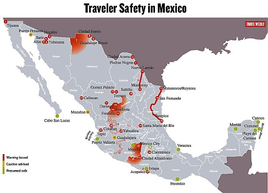
Over the past year, the US State Department has issued repeated warnings about travel in Mexico. Some of these warnings are specific to certain stretches of highway; others are broader and focus on cities or regions.

Travel Weekly has produced a handy map showing the areas currently affected by advisories (a version of this map appears below). Resorts colored green are “presumed to be safe”, while yellow means “caution” and red means “warning issued”.

  • Link to the Travel Weekly pdf map with full details, explaining the significance of each numbered location,
Traveler Safety in Mexico. Map Credit: Travel Weekly – www.travelweekly.com/mexicomap/

Note that “Sombrete” on the map, near Fresnillo, should actually be Sombrerete. (Curiously, this is the exactly same mistake made recently by the Victoria and Albert Museum in London in the text accompanying a display about silver in Latin America. Sombrerete was a very important silver-mining center during colonial times, and the town is well worth visiting, advisories permitting, for numerous fine colonial buildings).

Given the map, it is perhaps not really a great surprise that Mexico’s federal Tourism Department is currently actively promoting the Caribbean coast and “Mundo Maya” (Maya World), a region well removed from the red-colored zones on the map.

According to a slew of articles in Mexico’s Spanish-language press:

Are Mexico’s large cities growing faster than small cities?

 Excerpts from Geo-Mexico  Comments Off on Are Mexico’s large cities growing faster than small cities?
Jun 232011
 

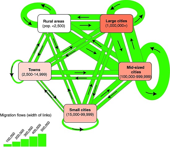
Aside from intra-urban moves (ie. those made within a city or town), the major focus of migration in Mexico has shifted from the largest cities to the medium cities (those with a population under one million). Medium cities, such as Mérida, San Luis Potosí, Querétaro and Hermosillo, attracted over 1.6 million new migrants compared to only about 1.3 million for the largest cities. The net migration gain of medium cities was almost 370,000, nearly twice that of the nine largest cities. The new focus of migration on medium cities rather than largest urban areas was stimulated by policies to shift growth away from Mexico City. This shift should help relieve the growing congestion in Mexico City and the other large cities.

Migration between municipalities, 1995-2000, by settlement size
Migration between municipalities, 1995-2000, by settlement size. Credit: Tony Burton; all rights reserved

The pattern of migration from small towns and rural areas to urban municipalities continued throughout the 20th century and into the 21st century. Between 1995 and 2000 over 1.7 million migrants left small towns and rural areas (see diagram). Where did these migrants go? Over 60% went to cities of over 100,000, which is not surprising because these cities have more dynamic economies with more employment opportunities. What is a bit surprising is that a full 27% moved to other small towns and rural areas. Many of these moves were to new corporate agricultural developments in the north. Personal and family factors were also important.

Rural areas and small towns attracted almost 1.2 million migrants during the five year period. Over 60% came from cities of over 100,000, while almost 40% came from other towns and rural areas. Many of these moves were undoubtedly earlier migrants returning to their hometowns. The net migration loss of over half a million represented only about 1.6% of the population for the five year period. This is only about one eighth of the natural population increase in these areas. In summary, though small municipalities are experiencing relatively large rates of out-migration, they are also attracting many migrants. Their relatively low rates of net migration loss mean that Mexico should continue to have a substantial rural population for the next several decades.

– 0 – 0  –

This post is an excerpt from chapter 25 of Geo-Mexico: the geography and dynamics of modern Mexico. Buy your copy today, and learn more about Mexico’s fascinating geography. The more knowledge you acquire, the more pleasure you will derive from your next trip to Mexico!

Mexico’s role in the birth control revolution

 Other  Comments Off on Mexico’s role in the birth control revolution
Jun 212011
 

The oral contraceptive pill, often referred to simply as “the Pill” will be officially sixty years old on October 15, 2011. In the words of The Economist: it “was arguably the first lifestyle drug to control a normal bodily function—fertility—rather than a dread disorder. It transformed the lives of millions and helped reshape the role of medicine in reproduction.” Its social impact was massive, helping to foment the sexual and feminist revolutions.

From a geographic perspective, the Pill coincided with ever-increasing concern about the rate of world population growth, and its impact on resources –  the start of an era which led to such seminal works as The Population Bomb and The Limits of Growth.

Initially, the development of the Pill was met by medical, religious and social furor, much of which has since subsided. Even though its popularity has declined since the 1960s, because of concerns about possible side effects, it is estimated that it is still used, in one form or another, by more than 80 million women worldwide.

Curiously, the synthetic female sex hormone called norethindrone was first synthesized from, believe it or not… Mexican-grown yams!

Equally interestingly, the Pill was not developed in a huge laboratory belonging to a major pharmaceutical company but in a relatively humble laboratory in Mexico City, belonging to a small company called Syntex. Syntex specialized in making steroids from Mexican yams, using methods of synthesis invented by a maverick biochemist, Russell Marker. Marker had published various studies on diosgenin, a saponin isolated from a Mexican yam species of the genus Dioscorea, and had discovered how to synthesize the human hormone testosterone and progesterone from diosgenin. After having his proposals for the large-scale production of human steroids from diosgenin turned down by U.S. pharmaceutical companies, Marker moved to Mexico and began his own, home-based, small scale production. This was so successful that a new company, Syntex, was soon born, specifically to make steroids from Mexican yams. Syntex quickly became the world’s largest producer of progesterone, as well as making testosterone and the female hormone esterone.

Enter Carl Djerassi. Djerassi was an Austrian-born chemist who had completed his PhD at the University of Wisconsin (1945) by researching the synthesis and transformation of steroids, including sex hormones. After working four years as a research chemist with CIBA Pharmaceutical Co. in Summit, New Jersey, he decided on a strategic move, in 1949, to join Syntex, in Mexico City, as associate director of chemical research.

At Syntex, Djerassi set out to see if diosgenin could be made to yield other steroids, which do not actually exist in nature, but which retain the biological activities of progesterone and are also orally active. The original aim of his team was to develop a drug for infertility and menstrual disorders that could be swallowed, as opposed to injected. Only two years later, on October 15, 1951, the group led by the then 28-year-old Djerassi, had synthesized norethindrone, a “super-potent orally active progestational agent”, which turned out to be the key ingredient in The Pill. (Chemically, norethindrone is 17a-ethinyl-19-nortestosterone; its generic name in Europe is norethisterone).

Later, the drug’s ability to suppress ovulation was demonstrated by Gregory Pingus at the Worcester Foundation in Massachusetts and clinical trials began. The rest, as they say, is history!

Djerassi is Emeritus Professor of Chemistry at Stanford University with an extremely distinguished scientific record, holding no fewer than 19 honorary doctorates in addition to numerous other honors. He is also one of only a handful of American scientists to have been awarded both the National Medal of Science (1973, for the first synthesis of a steroid contraceptive, The Pill) and the National Medal of Technology (1991, for promoting new approaches to insect control).

In medicinal chemistry he will be forever associated with the initial developments in the fields of oral contraceptives (Norethindrone), antihistamines (Pyribenzamine) and topical corticosteroids (Synalar).

They say that the well-rounded man combines scientific inquiry with artistic appreciation, and Djerassi is certainly no exception, having turned, in later life, to science fiction writing, examining the human side of scientists and the personal conflicts they face in their quest for knowledge, personal recognition, and financial rewards. One of his plays, “An Immaculate Misconception,” premiered in 1998 at the Edinburgh Fringe Festival and has since been performed in London, San Francisco, Sweden, Vienna and Cologne. It was also broadcast on BBC World Service Radio in May 2000.

Sources:

The idea for this post originated from a review in The Economist (October 13, 2001) of two books: Sexual Chemistry: A History of the Contraceptive Pill (Lara Marks, Yale) and This Man’s Pill. Reflections on the 50th Birthday of the Pill. (Carl Djerassi, Oxford University Press).

Several chapters of Geo-Mexico: the geography and dynamics of modern Mexico discuss Mexico’s population dynamics and trends, and their implications for future development. An earlier post here links to a pdf file showing Mexico’s population pyramid in 1990, and the predicted pyramid for 2050.

Key geographic indicators from Mexico’s 2010 Census

 Updates to Geo-Mexico  Comments Off on Key geographic indicators from Mexico’s 2010 Census
Jun 202011
 

This post summarizes some important characteristics of Mexico’s population and households, as revealed by the definitive results of the 2010 population census.

Literacy

5.3 million Mexicans over the age of 15 are unable to read and write a simple message (i.e. they are functionally illiterate). The highest rates of illiteracy are in Chiapas (17.0%), Guerrero (16.7%) and Oaxaca (16.3%), with the lowest rates in Mexico City (2.1%), Nuevo León (2.2%) and Baja California and Coahuila (both 2.6%).

Average Age

The average age of Mexico’s population has risen from 22 years in 2000 to 26 years in 2010. In 2010, 29% of the population was under the age of 15 (compared to 34% in 2000) and 6.3% was in the 65+ age group (compared to 5.0% in 2000).

Dependency ratios

The dependency ratio of a population is worked out by comparing the number of people of working age (normally taken to be 15-64 years old) with the number of young people (under age 15) and elderly (65+ years old). The dependency ratio has shifted from 64 dependents in every 100 people (64/100) in 2000 to 55/100 in 2010. More significantly, of the 64 dependents in 2000, 56 were children and 8 were elderly, whereas of the 55 in 2010, 45 were children and 10 were elderly. This is a clear shift towards an “elderly-dependent” population.

Fertility and education

The 2010 census shows that women of child-bearing age (15-49) have had an average of 1.7 children each, compared to 2.0 children in 2000. The averages mask enormous differences in rates. For example, women with a senior high school (preparatoria) education have 1.1 children on average, compared with 2.5 children for women who only completed secondary school, 3.3 children for those who completed primary education, and 3.5 children for those without any formal education.

Household possessions

Almost all (93%) of Mexico’s 35.6 million households have at least one TV, 82.1% have refrigerators, 65% cell phones, 45% have a vehicle, 43% a fixed telephone line, 29% a computer, and 21% have Internet access.

Jun 182011
 

ITESM, a university based in Monterrey, established Mexico’s first internet connection in 1989. Other universities soon followed. In the late 1990s Telmex started to provide internet service to businesses and the general public. Other providers entered the market but by 2005 Telmex still had about 80% of the market.

Public access via internet cafes is relatively inexpensive. With computers in many schools and cyber cafes in most Mexican towns, about 21% of Mexicans used the internet in 2007. This is relatively low compared to 94% in South Korea, 73% in Canada and the USA, 27% in Peru, 35% in Brazil and 26% in Argentina. Though Mexico is ahead of China (16%), Guatemala (10%) and India and Nigeria (7%), it is still lagging in internet use relative to its overall level of development.

An impressive three-quarters of Mexico’s personal computer internet connections are broadband. Internet use is highest in urban centers but is making steady inroads into rural areas. The highest usage is among 12- to 18-year-olds, with slightly more male users than female. However, less than a third of those in this group use the internet. Just under half of internet use is in the home, the rest is in schools, offices, public centers or cybercafes. About 44% of all users visit the internet for educational purposes, 40% for e-mail, 35% for general information, and 21% for online telephoning (VOIP). The internet is having an enormous impact on Mexican society.

Digital divide map

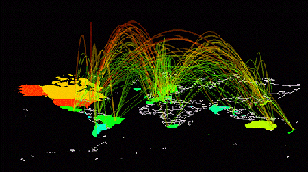
Internet traffic flows Credit: Stephen Eick, Bell Labs / Visual Insights (www.visualinsights.com)

The digital divide

Overall, just how well does Mexico do in terms of the digital divide? The Digital Access Index (DAI) is a compound index assessing the level of information and communications technologies (ICTs) that a country possesses. The DAI combines variables measuring infrastructure, affordability, literacy and educational level, the availability of broadband, international internet bandwidth per person and internet usage. Sweden placed highest in 2002 with a score of 0.85 out of a maximum possible score of 1.0. Canada and the USA were in equal 10th place.

Mexico (index: 0.50) placed a lowly 65th of the 180 countries in the rankings, level with Brazil but well ahead of China (0.43). Though digital communications in Mexico are expanding rapidly, Mexico lags behind rival countries in these important technologies. This could possibly hamper Mexico’s future ability to compete economically in the increasingly flat world of free trade.

There are some encouraging signs, though, that Mexico is catching up. For example, data for 2008 show that it has become the country with the 8th highest number of internet hosts, the services which provide access to internet servers.

– – –

Want to know what it feels like on the wrong side of the Digital Divide? Try the ICTP Digital Divide Simulator!

The text of this post is an excerpt from chapter 18 of Geo-Mexico: the geography and dynamics of modern Mexico. Buy your copy today, and learn more about Mexico’s fascinating geography. The more knowledge you acquire, the more pleasure you will derive from your next trip to Mexico!

How ecological is ecotourism in Mexico?

 Excerpts from Geo-Mexico  Comments Off on How ecological is ecotourism in Mexico?
Jun 162011
 

Ecotourism is often touted as one solution to many of the potential woes associated with conventional resort tourism. It should come as no surprise to find that Mexico has embraced ecotourism: Mexico’s biodiversity is phenomenal. It is one of the five most important countries in the world in terms of biodiversity:

To be ecologically successful, ecotourism probably has to be small-scale. Constructing the infrastructure necessary for large-scale coastal ecotourism projects often involves the destruction of highly productive (in ecological terms) wetlands, including tropical mangroves. These ecosystems play a vital role in helping preserve biodiversity and their destruction has serious long-term economic implications for fishing, port and marina access, coastline preservation and beach-based tourism.

Marine biodiversity

Mangroves (pictured on the right of the image) are especially vulnerable, with an undeserved reputation for being impenetrable thickets harboring noxious insects and reptiles. Mangroves sequester carbon and help reduce the organic content of water. Their roots bind unstable coasts, preventing erosion and acting as a natural barrier against hurricanes. They are important breeding, shelter and feeding places for fish, crustaceans and birds as well as being a source of charcoal, firewood, wood and roofing materials. They offer economic opportunities of fishing for shrimp, mollusk, fish and crustaceans.

In the year 2000, the total area of mangroves along Mexican coasts was estimated at 880,000 hectares (2.2 million acres), approximately two-thirds on the Atlantic and Caribbean coasts, and one-third on the Pacific. The annual loss of mangroves is estimated to be between 2.5% and 5% of this area. Even with the lower rate of loss, by 2025 mangroves will occupy only half of their 2000 area. In 2007 Mexico enacted federal legislation to protect existing mangroves.

The unique habitats of coral reefs are also at risk. Mexico has important zones of coral from the Baja California Peninsula and Sea of Cortés in the north to Cozumel Island and Chinchorro Bank in the south. The latter area is the northernmost extension of the Meso-American Barrier Reef system which is the world’s second largest reef system after Australia’s Barrier Reef. Marine pollution, overfishing and tourism have all hastened the decline of coral reefs,though many areas are now protected.

Even animal migrations are considered at risk. Some studies have shown that the number of tourists viewing the whale migrations off the coast of Baja California, for instance, is already having an adverse effect on the whales’ breeding habits.

– – –

This is an excerpt from chapter 19 of Geo-Mexico: the geography and dynamics of modern Mexico. Buy your copy today, and learn more about Mexico’s fascinating geography. The more knowledge you acquire, the more pleasure you will derive from your next trip to Mexico!

Wildlife trafficking in Mexico: how many wild parrots are illegally captured each year?

 Mexico's geography in the Press, Updates to Geo-Mexico  Comments Off on Wildlife trafficking in Mexico: how many wild parrots are illegally captured each year?
Jun 142011
 

In this post we return to The thorny issues of plant and animal trafficking and biopiracy in Mexico. We highlight several recent news items related to wildlife trafficking, as well as an important survey of the illegal parrot trade in Mexico.

Mexican police launched dozens of raids on stores and markets in March 2010, looking for illegally-traded plants and animals. They collected more than 4500 live specimens, representing more than 110 different species, ranging from cacti and orchids to tropical fish, parrots, reptiles and puma cubs. The mortality rate while transporting illegally-traded animals is more than 90%, according to wildlife experts.

The following month, Mexican federal police rescued 10 tigers and jaguars held captive in Cancún as a tourist attraction, while in June 2010, police at Mexico City’s international airport arrested a Mexican traveler who arrived from Peru with 18 tiny endangered monkeys strapped around his waist. Anyone convicted in Mexico of the illegal trafficking of animals can be sentenced to up to nine years in prison.

The scale of Mexico’s animal-trafficking problem is staggering. For example, according to the Defenders of Wildlife Mexico Program, “It is estimated that between 65,000 to 78,500 parrots are caught illegally every year.” (“The Illegal Parrot Trade in Mexico: A Comprehensive Assessment“)

The states with the worst records for numbers of parrots taken in the wild are Oaxaca and Chiapas (15,000 parrots a year each), Nayarit (12,500), Campeche (10,000) and Guerrero (5,000). Most of these parrots are thought to stay in Mexico, though up to 9,000 a year taken across the border into the USA.

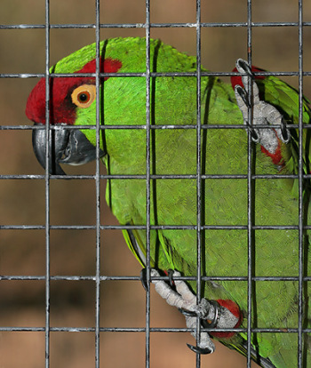
Thick-billed Parrot in captivity

Thick-billed Parrot in captivity

Most of the trafficking in wildlife is carried out by organized international crime networks. Mexico is a major hub for the international trade in wildlife, both because of its rich biodiversity, and because of its proximity to the USA, one of the world’s largest markets for exotic plants and animals. The global trade in illegal wildlife is thought by Interpol to be worth $20 billion a year.

Related posts:

Chapter 5 of Geo-Mexico: the geography and dynamics of modern Mexico focuses on ecosystems and biodiversity.  Chapter 30 analyzes environmental issues and trends including the impact of Old World species imported by the Spaniards, current environmental threats, and efforts to protect the environment.  Buy your copy today to have a handy reference guide to all major aspects of Mexico’s geography!


Why Las Tuxtlas Biosphere Reserve is well worth a visit

 Other  Comments Off on Why Las Tuxtlas Biosphere Reserve is well worth a visit
Jun 132011
 

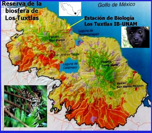
In a recent post, we looked at an Enchanted Lake in southern Mexico, in the Sierra de las Tuxtlas, near Catemaco in the Gulf Coast state of Veracruz. In this post we take a look at the surrounding Las Tuxtlas Biosphere Reserve.

Tuxtlas biosphere reserve

Scenically, the entire Tuxtlas region is one of the most fabulously beautiful in all of Mexico. High temperatures combined with lots of rainfall result in luxuriant vegetation and boundless wildlife. Average monthly temperatures range from a pleasant 21 degrees C (70 degrees F) in January to a high of 28 degrees C (82 degrees F) in May, just before the rainy season kicks in. During the rainy season, from June to October, some 2000 mm (79 inches) of rain falls, often in late afternoon tropical deluges.

The jungle masking the lower slopes of the San Martín volcano gradually merges into tropical cloud forest at higher altitudes. Competing with the Silk Cotton (Kapok) and Ficus trees for light and sustenance are ground-hugging ferns. Overhead, the tangle of tree branches provides support for thousands of non-parasitic bromeliads (“air” plants) and orchids. More than 1300 species of flowering plants have been identified in this classic area for Neotropical ecology.

Bird-watchers are likely to spot the spectacular Keel-billed Toucan, or hear a Tody Motmot. Smaller birds include several species of hummingbird; look for the endemic Long-tailed Sabrewing. About half of all the bird species recorded in Mexico have been seen here, but birds are not the only wild animals inhabiting the jungle. Ocelots and tapirs are regularly seen and you may be lucky enough to see spider monkeys playing overhead in the canopy.

Clearance of the land for grazing and cultivation of the slopes to grow tobacco, bananas and sugar cane have reduced the original jungle to a relatively small number of isolated fragments. Fortuitously, this provides more varied habitats than the original vegetation, helping to enrich the area’s wildlife, further enhancing the region’s reputation as an ornithological and botanical paradise.

Fortunately an extensive area of this region was declared a Biosphere Reserve in 1998, ensuring that conservation programs now go hand-in-hand with human activities. The total area forming the Reserva de la Biósfera “Los Tuxtlas” is 155,122 hectares (380,000 acres).

Chapter 5 of Geo-Mexico: the geography and dynamics of modern Mexico focuses on Mexico’s ecosystems and biodiversity.  Chapter 30 analyzes environmental issues and trends including current environmental threats and efforts to protect the environment.  Buy your copy today to have a handy reference guide to all major aspects of Mexico’s geography!

How did Mexico get to be the world’s 11th most populous country?

 Other  Comments Off on How did Mexico get to be the world’s 11th most populous country?
Jun 112011
 

Mexico is currently the world’s 11th most populous country. While it has not always held this position, Mexico has been among the world’s population leaders for the last two thousand years. Worldmapper.org provides data on the estimated population occupying the areas of current countries for various years starting in the year one, when India (62 million) and China (60 million) had more than half of world’s total population of 231 million. No other country had more than eight million. Mexico ranked 17th with an estimated two million inhabitants. According to available data eight countries have always been more populous than Mexico: China, India, Bangladesh, Russia, Pakistan, Japan and Indonesia.

The next data point is the year 1500, when Mexico ranked 13th with an estimated population of seven million. This estimate seems reasonable, though some feel that Mexico’s population might have been as large as 15 million which would have made Mexico the third most populous country on the planet behind only China and India. Between year 1 and 1500, Mexico surpassed Turkey, Spain, Egypt, Iran, and the Ukraine; but was passed by Germany.

Mexico’s total population plunged after the Spanish arrived bringing small pox, other diseases and major social disruption. By 1600, Mexico’s population was down to 2.5 million, but it was still the most populous country in the New World, according to data provided by gapminder.org. It ranked 22nd tied with Austria and behind such countries as Czechoslovakia, Poland, Sudan, and Yugoslavia.

In 1700 Mexico’s population was 4.5 million, ranking it 18th. By 1820 the USA had moved past Mexico’s population of 6.6 million to become the most populous country in the New World. Mexico maintained its 19th ranking until 1870 when Brazil surpassed Mexico’s population of 9.2 million to become the most populous country in Latin America. It is interesting that there were relatively few changes in the ranks of the top 20 countries during the 170 year period between 1700 and 1870, except for the USA which went from 40th to 4th.

Since 1870 Mexico’s population has surpassed that of nine different European countries. By 1900 Mexico had 11.7 million inhabitants moving it past Czechoslovakia and Turkey into the 18th spot. (Note that Gapminder population figures are higher than the Mexican census figures, perhaps because they attempted to correct for census under-counting; for the purposes of this analysis we use the Gapminder figures.) Mexico maintained its 18th rank until 1950 when its population of 28.5 million edged it past Spain and war torn Poland into 16th place. In 1970 its population reached 52.8 million putting Mexico in 14th place ahead of France and the Ukraine. By 1980 Mexico’s population of 68.3 million pushed it past Italy and Britain into 12th place. A decade later its population of 84.9 million moved Mexico past Germany into the 11th spot, where it has remained.

What will happen in future decades? Mexico’s position will change, but only slightly. In 2020, Mexico’s population may reach 125 million moving it past Japan into 10th place (Population forecasts for 2020 to 2050 are from the U.S. Bureau of Census). By 2030, Mexico, with a population of about 135 million, will have passed Russia, but fallen behind Ethiopia and the Philippines, putting it back in the 11th spot.

Mexico’s estimated population of 144 million in 2050 will place it 12th behind the Congo (World Population Prospects: the 2010 Revision). According to the United Nations, by 2100 Mexico’s population will decrease to 127 million moving it to the 20th spot, behind Tanzania, Uganda, Kenya, Iraq, Zambia, Niger, Malawi, and Sudan. Obviously, the accuracy of such a long term forecasts is very speculative. For example, given global climate change and possible food scarcities, some doubt if the sub-Saharan African countries can grow as rapidly during the last half of the 21st century as projected by the United Nations.

Jun 102011
 

‘War is God’s way of teaching Americans geography.”

This quote is commonly attributed to Ambrose Bierce, the American journalist and satirist, who fell off the map in Revolutionary Mexico in 1913, never to be seen again. However, as pointed out by an alert reader (see comments), the quote has never been established as originating with Bierce and may well derive from “War was God’s way of teaching us geography”, a line delivered by comedian Paul Rodriguez in 1987 (quoted in the LA Times).

To ensure that this post has a link to Mexico, In The Devil’s Dictionary, Bierce defined Boundary:

BOUNDARY, n. “In political geography, an imaginary line between two nations, separating the imaginary rights of one from the imaginary rights of the other.”

The changing political frontiers of Mexico are the subject of chapter 12 of Geo-Mexico: the geography and dynamics of modern Mexico, your handy reference guide to all aspects of Mexico’s geography. Ask your local library to buy a copy TODAY! Also available from amazon.com

Jun 092011
 

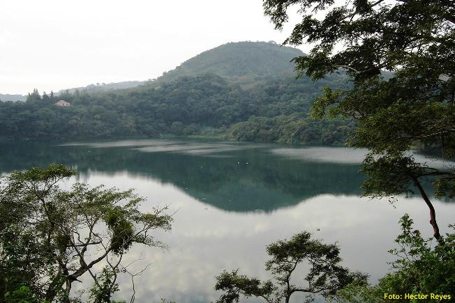
Peculiar, but true. There are several lakes named Laguna Encantada (Enchanted Lake) in Mexico, but this one is near Catemaco in the Tuxtlas region of the state of Veracruz. Catemaco is famous for its witches, so perhaps one of them cast a spell on the lake, making it behave perversely, its level changing in opposition to all the other lakes in the country?

Laguna Encantada

Laguna Encantada, Veracruz. Photo credit: Hector Reyes

Occupying the crater of an extinct volcano, La Laguna Encantada is a truly beautiful lake, especially near sunrise or sunset. Laguna Encantada is located 3 km northeast of San Andrés Tuxtla. The access road is unpaved. The views are ever-changing on the easy walk of about 1500 meters (slightly under one mile) around its shoreline. As you walk, try counting the butterflies. A study twenty years ago recorded a staggering total of 182 different species in this relatively small area of jungle.

The lake nestles on the southern flank of the San Martín volcano. This dormant volcano is a prominent landmark north-west of Lake Catemaco close to San Andrés Tuxtla. Its crater, 1500 meters across, is at a height of about 1400 meters above sea level, and has two small subsidiary cones inside it.

The basaltic lavas and layers of ash forming the volcano are highly permeable and porous. As a result, despite the heavy rainfall, there are no permanent streams flowing down the upper slopes.

Some distance away from the volcano, though, there are several good-sized lakes including Catemaco and Laguna Encantada. Catemaco is large enough to capture plenty of rainfall to maintain its level. The much smaller basin holding Laguna Encantada (350 meters above sea level), however, does not receive sufficient rain to keep its level high.

Instead, and this is the wonder of La Laguna Encantada, much of its water supply comes from underground. Water that falls on the slopes of the San Martín volcano during the rainy season soaks into the ground and then percolates slowly towards the lake, so slowly that it takes six months to reach it. The result? The lake is unable to sustain its level during the rainy season, but the underground water reaching it in the dry season is more than sufficient to replenish its level. Maybe the witches of Catemaco have something to do with it, but hydrology also plays a part!

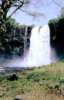
Eyipantla Falls

Eyipantla Falls Photo: Tony Burton

Salto de Eyipantla

Only a few kilometers from Laguna Encantada is another wonderful natural sight: the Eyipantla Waterfall (Salto de Eyipantla). The water for the falls comes from the Comoapan river, which drains Lake Catemaco. After heavy rain, the curtain of water at Eyipantla is about 50 meters high and 20 meters wide. The sunlight playing on the water creates a dazzling display of magical colors. The Tuxtlas region has been the setting for numerous movies and commercials and the impressive Eyipantla Falls have starred in many of them. The unusual name, Eyipantla, reflects its three chutes of water, and is derived from the Nahuátl words, eyi (three), pantli (trench) and tla (water).

Chapter 4 of Geo-Mexico: the geography and dynamics of modern Mexico discusses Mexico’s diverse climates.  Chapter 5 focuses on ecosystems and biodiversity.  Chapter 30 analyzes environmental issues and trends including the impact of Old World species imported by the Spaniards, current environmental threats, and efforts to protect the environment.  Buy your copy today to have a handy reference guide to all major aspects of Mexico’s geography!

How were the Piedras Encimadas (Stacked Rocks) in Puebla, Mexico, formed?

 Other  Comments Off on How were the Piedras Encimadas (Stacked Rocks) in Puebla, Mexico, formed?
Jun 072011
 

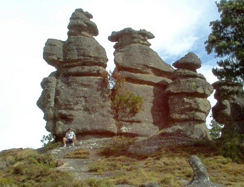
The Valle de las Piedras Encimadas (Valley of the Stacked Rocks) is 150 km from the city of Puebla in the northern part of the eponymous state. The Piedras Encimadas are rock outcrops occupying an area of about 4 square km (990 acres) centered on a small valley at an altitude of 2400 meters above sea level. The dominant natural vegetation is pine-oak forest. The main natural attraction of the area are the numerous, fascinating and photogenic”stacked rock” formations.

Piedras Encimadas, Zacatlán
Piedras Encimadas, Zacatlán, Sierra Norte, Puebla

The stacked rocks of the Piedras Encimadas can easily be likened to people (soldiers, sentries) and animals (dinosaurs, elephants, turtles), depending on the sensibilities of the observer. The shapes appear even more “fantastic” on the frequent occasions when clouds roll into the valley, enveloping the rocks in a thin mist.

According to geography researchers from the National University (UNAM), the volcanic rocks (rhyolites and andesites) forming the Piedras Encimadas date from the Tertiary period (60 million years BP).

The Piedras Encimadas look very similar to the much-studied granite “tors” found in the UK and elsewhere. Indeed, they may even have been formed in a similar way. However, geologists still debate precisely how tors were formed, and their uncertainties almost certainly apply equally to the Piedras Encimadas.

  • Theories for the formation of tors on Dartmoor, UK

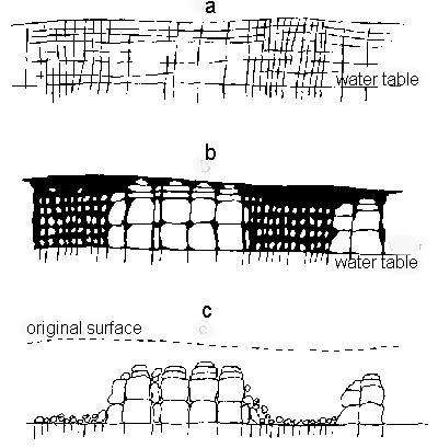
Most theories of tor formation (see link)  involve the concept of “differential weathering”. This occurs when some parts of an area weather (disintegrate) more rapidly than others. Differences in weathering rates result from a variety of reasons, including differences in rock types and resistance within the same rock type, as well as localized changes in the climate, vegetation cover, aspect (direction the slope faces), altitude or exposure to air or water.

Tor formation (after Linton).
Tor formation (after Linton). Fig 3.5 of B.W. Sparks: Rocks and Relief (1971)

Over a long period of time, the weaker parts of the rock may have been weathered to greater depths than the more resistant parts. If subsequent erosion, most likely by river action in the context of Puebla, stripped away all the weathered rock, it would leave the more resistant rock as upstanding craggy outcrops (see sequence diagram above)

The shape of many of the blocks of rock forming the Piedras Encimadas does suggest that they were originally weathered deep underground from chemical reactions they underwent as water percolated slowly down towards the water table. Such a process would have acted more on the upper faces of each block, rather than the lower faces, producing a block that was rounded above, and almost flat below.

If the blocks had been modified by erosion (the other major possible interpretation), then it is more likely that both the upper and lower faces of each block would be equally rounded or that the lower face would be more eroded than the upper face.

Regardless of the details, it is almost certain that the curiously-shaped Piedras Encimadas were formed by a combination of volcanic action, differential weathering and erosion. The Piedras Encimadas offer lots of interesting possibilities for geography fieldwork.

Related posts:

Jun 062011
 

Mexico’s aerospace sector attracted $1.25 billion in investments in 2010, 25% more than in 2009. The city of Querétaro has become the hub of Mexico’s fledgling aerospace sector, with several companies choosing it as an ideal manufacturing location. Opening a new section of the Bombardier plant in the city of Quéretaro, President Felipe Calderón highlighted the sector’s rapid growth in Mexico; the 200 firms in the sector currently provide 30,000 jobs. The federal government believes that Mexico can become a producer of planes for international markets within the next 5 to 10 years.

Canada-based Bombardier supplies 38% of the world’s business airplane market, and predicts a significant growth in the sector over the next few years. The Bombardier plant in Querétaro will make the fuselage and electrical systems for the new Learjet 85 business aircraft. Bombardier has committed $450 million over the next seven years to expand the plant.

Another firm starting production in Querétaro is Eurocopter, a leading manufacturer of helicopters. It is investing $550 million to build a factory to make components for the aeronautical industry, primarily for export. The components include door structures and tail sections for Airbus and other planes.

A third major company, General Electric, the US-based multinational, has opened its own new advanced engineering center in the city of Querétaro. The $20 million, 8,000-square-meter center is part of a facility making parts for the Airbus 380 airliner. It will specialize in research and design of airplane turbines and power systems. The center, the only one of its kind in Latin America, will employ more than 1,300 highly qualified engineers. It is General Electric’s largest engineering center outside the USA.

Supporting the growth in aerospace industries is Querétaro International Airport, which has drastically reduced its non-renewable energy consumption (and energy costs) by becoming almost totally self-sufficient, relying on solar power. The airport’s solar panels have an installed capacity of 924KW, allowing the airport to profit from feeding surplus electricity back into Mexico’s national electricity grid.

Why has Querétaro become the center of Mexico’s fledgling aeronautical industry?

  • City is centrally located with excellent transport links via highways and railways to both coasts and to several US border crossings.
  • It is relatively close to Mexico City, the seat of political power and location of almost all federal offices
  • It has a large, well-educated, easily trained and skilled workforce
  • The city currently has fewer security concerns than possible rivals such as Monterrey in Nuevo León.
  • Mexico has a highly competitive business environment with numerous major international manufacturing facilities for other kinds of vehicles.

The changes reflect the trend in Mexico’s manufacturing sector away from high volume, low-cost manufacturing processes towards higher value, high tech industries.

Are Mexicans the world’s hardest-working people or the least productive?

 Books and resources  Comments Off on Are Mexicans the world’s hardest-working people or the least productive?
Jun 042011
 

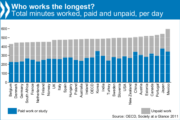
The headline — “Mexicans work longer hours than anyone else” — said it all, or did it? A recent report from the OECD (Organisation for Economic Co-operation and Development) found that Mexicans worked longer hours than people in any other OECD country, devoting 10 hours a day to paid and unpaid work (the latter includes housework and cooking). By contrast, Belgians work the least, only 7 hours. The OECD average is 8 hours a day. Is the positive spin simply because the OECD is currently headed by Mexican economist Dr. Angel Gurría?

The figures come from the latest edition of OECD’s Society at a Glance (2011), which gives an overview of social trends and policy developments in all member countries. Using indicators taken from OECD databases and other sources, it shows how societies are changing over time and how different countries compare.

Most unpaid work is housework. Mexicans do the most, more than 3 hours per day, and Koreans the least, only 79 minutes. Mexicans spend more time cooking than is customary in most other countries. The inhabitants of the USA spend the least time cooking each day, barely 30 minutes, and Turks the most, 74 minutes. Most people spend around 50 minutes a day cooking. Shopping also makes up a big part of unpaid work. The OECD average is 23 minutes a day, with the French spending the most (32 minutes) and the Koreans the least (13 minutes).

OECD: Working Hours

OECD: Working Hours

The report also attempts to estimate how much unpaid work is worth as a percentage of GDP for the 25 OECD countries for which data are available. It finds that the value of unpaid work is considerable, equivalent to about one-third of GDP in OECD countries, ranging from a low of 19% in Korea to a high of 53% in Portugal.

From a Mexican perspective, this may all paint a very rosy picture. However, as other commentators (see, for example, Burro Hall) have pointed out, it could equally well mean that Mexicans have the lowest productivity in the world, since they are working longer hours than other countries, but failing, in most sectors, to out-perform them!

Other highlights from the OECD’s Society at a Glance:

  • The 4 hours and 21 minute difference in unpaid work time between Mexican women and men is the largest in the OECD, where the average gap is 2 hours and 28 minutes
  • Mexicans have the second highest level of income inequality and the highest level of relative poverty in the OECD. One in every five Mexicans are poor, compared to just above one in ten on average across the OECD. Nearly half of Mexicans find it difficult or very difficult to get by on their current income.
  • Mexicans report the third highest positive psychological experiences (feeling rested, smiling, learning, and enjoyment) and lower than average negative experiences (pain, worry, stress, sadness, depression).

Review of Jeffrey M. Pilcher’s “¡Que vivan los tamales! Food and the making of Mexican Identity”

 Books and resources  Comments Off on Review of Jeffrey M. Pilcher’s “¡Que vivan los tamales! Food and the making of Mexican Identity”
Jun 022011
 

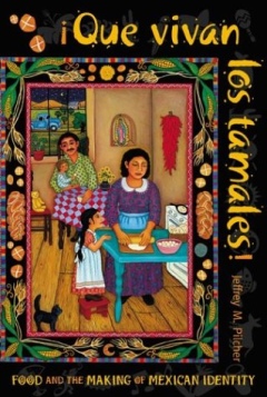
Are you interested in the geography of Mexico’s regional cuisines or the historical relationships between food preparation methods and gender roles in Mexican society? If so, add ¡Que vivan los tamales! Food and the making of Mexican Identity by Jeffrey Pilcher to your “Books Wanted” list.

Pilcher’s lively and entertaining account analyzes how the history of food in Mexico has been intimately tied to the country’s evolving national identity. The connections have become widely recognized, so much so that UNESCO recently conferred Intangible Cultural Heritage status on traditional Mexican cuisine, especially that of the state of Michoacán.

Pilcher cover of Que Vivan Los TamalesIn every chapter, Pilcher delves into the details. He explains how Mexico’s elites strongly preferred dishes based on wheat (first introduced into Mexico by early colonists) to those based on corn, one of Mexico’s many contributions to world cuisine. Indeed, they went so far as to argue that, across the globe, societies based on corn or rice would never rise above those based on wheat.

True appreciation of Mexico’s indigenous foods developed only slowly, mirroring the gradual development of nationalism, before coming to be considered a key component of the national identity. The advent of the railways in the 19th century allowed exotic foodstuffs to be marketed throughout the country for the first time. National cookbooks began to appear, highlighting the distinctive dishes of different regions, a trend continued to the present-day.

Technological developments have brought many changes. With industrialization, the time-consuming preparation of traditional corn tortillas was gradually superseded, especially in urban environments, by machine-made tortillas, whose taste is considered by connoisseurs to be greatly inferior to that of their hand-made equivalents, now increasingly restricted to relatively remote rural areas. Each step in the industrialization of tortillas brought massive social changes. Traditionally, the production of tortillas was the preserve of womenfolk, one of their numerous daily household chores. When mechanized tortilla presses were introduced, the making of tortillas quickly became an acceptable occupation for men. Freedom from the arduous work involved in making tortillas daily from scratch allowed women time to pursue other activities and to enter the formal workforce.

Gender, race, social class, dietary preferences, the fusion of indigenous cuisine and techniques with ingredients and methods imported from Europe and elsewhere… all are explored in this fascinating book.

Mexico’s cuisine is justly famous for its extraordinary regional variety; in just a few decades, the essential ingredients for Mexican food have become global commodities, appearing on supermarket shelves in dozens of countries around the world. Pilcher’s book puts this success in context, making it an essential read for anyone interested in the geography and history of Mexican cuisine.

Details (link is to amazon.com): ¡Que vivan los tamales! Food and the making of Mexican Identity by Jeffrey M. Pilcher (University of New Mexico Press, 1998).

Related posts:

For more about Mexican cuisine, visit the amazing award-winning blog Mexico Cooks! and also browse the huge selection of recipes, articles and tips about all aspects of Mexcan food and cooking in the “Cuisine” section of MexConnect. ¡Buen provecho!