More problems for residents of Valle de Chalco on the south-eastern edge of Mexico City

 Mexico's geography in the Press  Comments Off on More problems for residents of Valle de Chalco on the south-eastern edge of Mexico City
May 112011
 

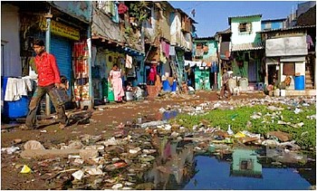
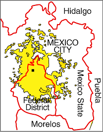
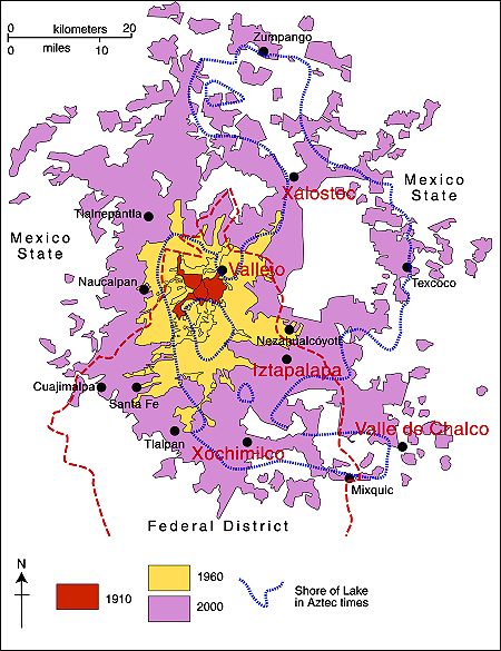
More than 200 homes in the low-income settlement of Valle de Chalco on the south-eastern edge of Mexico City, in the State of México, were flooded by raw sewage last month. The affected homes were in San Isidro and La Providencia, in Valle de Chalco (see map).

Mexico City cracks map
Locations in Valley of Mexico with high incidence of ground cracks. Cartography: Tony Burton; all rights reserved.

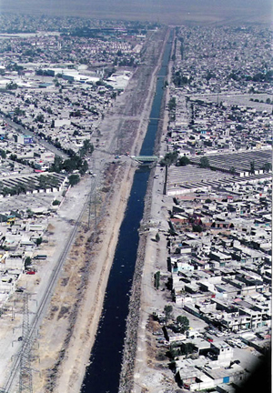
At least 500 residents faced a grim clean-up following several days of flooding. The problem was caused by a 30-meter-long crack in a surface sewage canal known as the Canal de la Compañia. The crack allowed 6,000 cubic meters a second of raw sewage to inundate nearby streets and homes. The federal water authority, Conagua, said that it would take three weeks to complete repairs to the canal wall.

Canal de la Compañia, Chimalhuacán

Canal de la Compañia, Chimalhuacán

The canal wall is thought to have been put under too much pressure due to the unfortunate combination of unusually heavy rains and a blockage occasioned by accumulated garbage such as plastic bags. It is possible that continued ground settling –More ground cracks appearing in Mexico City and the Valley of Mexico – also contributed to the problem. José Luis Luege Tamargo, the head of Conagua, placed much of the blame for the most recent flooding on the local municipal authorities of Ixtapaluca for not having ensured that no garbage was dumped anywhere in or near the Canal.

The 260 families and small businesses affected were all given some immediate financial assistance via 20,000-peso payment cards valid at any Soriano supermarket. In addition, authorities have pumped out basements and begun an emergency vaccination campaign.

The Canal de la Comañia’s walls have failed three times in the past decade, with serious flooding each time; the most recent disaster was in February 2010, when 18,000 people were forced to flee the rising wastewater. Conagua has reportedly proposed a more permanent remedy involving the rerouting of 7 km (almost 5 miles) of canal. The project would take two years to complete, with an estimated cost of 300 million pesos ($25 million).
The on-going transformation of Mexico City

 Mexico's geography in the Press  Comments Off on The on-going transformation of Mexico City
May 082011
 

A feature article in thestar.com (link below) summarizes some of the reasons behind our long-held view that Mexico City has started, and is still undergoing, a noteworthy transformation. Change is happening not only in the urban fabric but in many aspects of the daily lives of “capitalinos“, the most polite of the various  terms used in Mexico for residents of Mexico City.

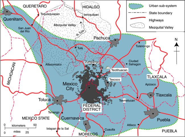
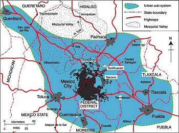
Map of Mexico City urban system

Map of Mexico City urban system. Click to enlarge. All rights reserved.

We will continue to offer occasional updates on the transformation taking place in Mexico City in future posts. Previous posts on this blog have examined many different aspects of Mexico City’s on-going transformation:

Mexico’s cities and towns are analyzed in chapters 21, 22 and 23 of Geo-Mexico: the geography and dynamics of modern Mexico. Buy your copy today!!

Attempts to provide drainage for Mexico City date back to Aztec times

 Excerpts from Geo-Mexico, Mexico's geography in the Press  Comments Off on Attempts to provide drainage for Mexico City date back to Aztec times
Apr 262011
 

An old joke relates how engineers initially rejoiced at successfully draining the former lake on which Mexico City was built (something the Aztecs had tried, but failed to achieve), only to discover that the city now lacked any reliable source of fresh water for its inhabitants (something the Aztecs had successfully managed by building a system of aqueducts).

Water has been a major issue for Mexico City since it was founded almost 700 years ago. Civil engineering works by the Aztecs included causeways and aqueducts connecting their island capital to the mainland as well as lengthy dikes separating the fresh water lakes from the brackish Lake Texcoco which surrounded the city.

The Spaniards did not maintain the Aztec civil works, deforested the surrounding hillsides, and started filling Lake Texcoco. This contributed to major flooding in 1555, 1580, 1604. The city was actually underwater (continuously!) from 1629–1634. During this period the Spaniards invested in several flood control efforts, but they were not successful. In 1788 they started construction of a massive canal to connect the basin to rivers north of the city flowing to the Gulf of Mexico. The open canal, which was up to 30 m (100 ft) deep in places, provided flood relief, but did not completely solve the problem, and flooding continued.

In the mid-1850s the government approved another massive flood relief scheme. Construction of the Gran Canal was delayed by numerous political and financial problems; it was not completed until 1900. The 58 km (36 mi) long canal included a 10 km tunnel, and carried lake water, storm water and sewage north to the Río Salado and eventually to the Gulf of Mexico. The scheme successfully drained most of the basin lakes, but summer flooding continued to be a problem for decades.

Mexico’s deep drainage system (drenaje profundo) was completed in the 1970s. It relies on a 68-km-long central tunnel (Emisor Central) which has a maximum depth of 250 meters below the surface. Built to allow for a flow of 170 cubic meters/second, subsurface subsidence under Mexico City had reduced its maximum capacity to barely 15 cubic meters/second by 2008.

Paradoxically for a city originally built on a lake and which experiences regular summer floods, Mexico City is desperately short of drinking water. The drilling of wells to obtain potable water from the aquifer under Mexico City is one of the main reasons for the ground subsidence which has reduced the effectiveness of the deep drainage system.

Many parts of Mexico City still experience serious drainage problems every rainy season. During the long dry season, many street drains plug with garbage (especially impermeable plastic bags). City motorists dread the first heavy rains of the year since much of the rainwater which falls is unable to find its way underground and backs up from blocked drains. City authorities have an annual campaign to try to clear all drains before the first rains, but are never completely successful.

Since 2007, jointly agreed programs to maintain and renovate the deep drainage system have been undertaken each year during the dry season by Mexico City and the administrations of adjoining states, in an effort to reduce the metropolitan area’s serious flood hazard. In the first four years (2007-2010), more than 42 km of tunnels have been renovated. The 2010-11 season of repairs to the drenaje profundo will be completed before the start of the rainy season (usually in late May or early June), according to city mayor Marcelo Ebrard.

Why are some parts of Mexico City sinking into the old lakebed?

Which Mexican states attract most migrants?

 Updates to Geo-Mexico  Comments Off on Which Mexican states attract most migrants?
Apr 252011
 

Mexico-USA international migration remains a hot topic in any “Geography of Mexico” program. But international migration is not the only form of migration in Mexico; internal (domestic) migration is also important. This includes people moving house within the same town or city, as well as those who move to a different town, city or state.

The most rapid period of urban growth in Mexico coincided with high rates of rural-urban migration. As the proportion of the total population residing in rural populations fell, the proportion of the population living in urban areas (defined in Mexico as settlements with a population exceeding 2,500) rose, a trend called urbanization.

Rural-urban migration within Mexico has slowed down dramatically in recent years, but internal migration is still very common, with increasing numbers of Mexicans opting to live in mid-sized cities (those with a population between 100,000 and 1,000,000). In many cases, this involves a change of state, and this post examines which states in Mexico have attracted the most migrants from other states or from outside the country.

The 2010 census reveals that 18.4% of people residing in Mexico were born in another Mexican state or in a foreign country. In Quintana Roo, 54% of the residents were born outside the state. These residents were mostly attracted to Quintana Roo by the rapidly growing tourist industry in Cancún and other resorts. Almost 13% of Quintana Roo residents moved into the state within the last five years.

Over 45% of Baja California residents, 1.4 million people, were born elsewhere, and almost 6% moved into the state in the last five years. These migrants were probably attracted to the growing employment opportunities in Tijuana and Mexicali. Some may be waiting to try to cross illegally into the USA or have already made an unsuccessful attempt and are contemplating their next move.

Baja California Sur has almost 40% who were born elsewhere and over 13% who moved into the state within the past five years. These migrants were mostly attracted to jobs created in the booming tourism industry and in the associated construction sector.

About 37% of residents in the State of Mexico, 5.6 million people, were born elsewhere. Migration to the State of Mexico is mostly linked to the suburbanization and counter-urbanization of Mexico City. Between 2005 and 2010, about half a million people moved out of Mexico City and over 380,000 of these settled in the State of Mexico and an additional 38,000 moved to Hidalgo which is part of Metropolitan Mexico City. (For the areas involved, see Is Mexico City sprawl a sign of a future megalopolis?) Similar processes are also taking place in Guadalajara, Mexico’s second-largest city: Population change in the Guadalajara Metropolitan Area.

States with rather low income levels and slow economic growth attracted few migrants. Only 3.6% of Chiapas residents were born outside the state, with 1.2% moving into Chiapas in the last five years. Interestingly, Chiapas also has one the lowest rates of out-migration. Other states with relatively few migrants are Guerrero, Oaxaca, Yucatán and Tabasco.

Internal migration in Mexico is the focus of chapter 25 of Geo-Mexico: the geography and dynamics of modern Mexico. Ask your library to buy a copy of this handy reference guide to all aspects of Mexico’s geography today! Better yet, order your own copy…

Micro-businesses help improve the economic and social outlook for irregular settlements

 Mexico's geography in the Press  Comments Off on Micro-businesses help improve the economic and social outlook for irregular settlements
Apr 072011
 

In previous posts about Mexico City’s low-cost and “irregular” housing areas, we have seen how the residents of Ciudad Nezahualcóyotl (Nezahualcoyotl, an irregular settlement which grew into a monster) have gradually transformed their urban environment, and are now regarded by some as part of Mexico’s growing middle class (Are the residents of Ciudad Nezahualcóyotl becoming middle class?).

Historically,  low-cost housing areas (Informal settlements or “colonias populares” in Mexico’s cities) have been established throughout the Mexico City metropolitan area, with the notable exception of the city’s high status western sector. The highest concentrations of colonias populares are in the industrial zones, at the periphery of the city, and in undesirable areas such as the former lakebed near Lake Texcoco which is unstable and prone to severe flooding. (See, for example, Subsidence incident leads to demolition of 31 homes in the State of Mexico).

In the 1950s, in an attempt to control urban growth, the Federal District government started to oppose the formation of new colonias populares. In contrast, the neighboring State of Mexico tolerated, and even encouraged, the development of such communities, explaining why numerous colonias populares were established just beyond the Federal District boundary, in municipalities such as Naucalpan, Tlalnepantla, Ecatepec, Chimalhuacán, and Nezahualcóyotl.

Many of these settlements grew very rapidly. For example, Chimalhuacán, on the Texcoco lakebed, just north of Nezahualcóyotl, grew from 20,000 in 1970 to 525,000 in 2005 and 614,000 in 2010. Similarly, Valle de Chalco Solidaridad, on the lakebed of the drained Lake Chalco, and alongside the main highway from Mexico City to Puebla, went from 44,000 in 1970 to 332,000 in 2005 and almost 358,000 in 2010. Currently, about 60% of the Mexico City Metro Area’s population lives in colonias populares.

Over time, almost all of the older, longer-established colonias irregulares in Mexico have been improved, though new ones still spring up almost overnight. It may take 10 years or so for them to look like a regular settlement and acquire some basic urban services (water, electricity, drainage). The first settlers starting a new irregular settlement are often referred to as paracaidistas (parachutists) in reference to the fact that they apparently arrive out of nowhere!

A recent article in Forbes magazine looks at how small businesses in Chimalhuacán are helping to transform the urban landscape and offer increasing opportunities for its residents.

The population figures quoted in the article must refer to a larger area than just the municipality of Chimalhuacán, but the processes described are typical of many colonias populares, augmented in this case by particularly enterprising entrepreneurs.

Prior to the 1960s, villages with telephone service in most parts of Mexico were served by a single “caseta” (phone booth), which inevitably became a center for village gossip. The early adopters who installed the first public phone booth in a particular village usually prospered, encouraging others to follow suit. Back then, phone service was mostly about keeping in touch with family, but now phones promise access to all kinds of services. The  contemporary phone booths (called Barafón, cheap phone) in Chimalhuacán, described in Forbes, greatly improve people’s access to affordable phone service, enabling them to obtain health care and employment information, as well as operate micro-businesses more efficiently.

As the Forbes article concludes, “While the imagery and condition of one of Mexico’s largest urban slums is grim, closer inspection reveals a thriving and ever so gradually modernizing environment.” Indeed. Like many other colonias populares, Chimalhuacán is well on its way to joining the 21st century.

Related posts:

Mexico’s cities and towns are analyzed in chapters 21, 22 and 23 of Geo-Mexico: the geography and dynamics of modern Mexico. Buy your copy today!!

Are the residents of Ciudad Nezahualcóyotl becoming middle class?

 Mexico's geography in the Press  Comments Off on Are the residents of Ciudad Nezahualcóyotl becoming middle class?
Feb 062011
 

In a previous post –Nezahualcoyotl, an irregular settlement which grew into a monster – we looked at the extraordinarily rapid growth of Ciudad Nezahualcóyotl (today a city of over 1.5 million inhabitants) from its start on the dried-up lake bed east of Mexico City in the 1950s.

Nezahualcoyotl, the city of dreams

Nezahualcoyotl, the city of dreams, now has its own Sears and Wal-Mart

The Economist special report on Latin America (11 September 2010) included an evocative description of Ciudad Nezahualcóyotl, well worth reading. It describes how “an impoverished settlement of dirt streets and one-storey shacks built of grey concrete blocks” [ed: see photo] has become “comfortable homes of two or three storeys” with asphalted streets and “traffic-clogged thoroughfares… lined with businesses of every type”. Next to a Wal-Mart and private hospital is a shopping center with Sears and C&A, boutiques and a multiplex cinema.

The inhabitants aspirations have changed from bicycles to private cars, and include hopes of a higher education and finding a well-paid position elsewhere. The article concludes that the rise in living standards of many of the people is (arguably) creating  a “middle class” society, before examining the concept of “middle class” in much more depth.

Is drug war violence concentrated in Mexico’s largest cities?

 Updates to Geo-Mexico  Comments Off on Is drug war violence concentrated in Mexico’s largest cities?
Feb 012011
 

It is commonly believed that crime and murder rates are highest in the largest cities. Is this the case for Mexican drug war deaths? Recently available data (from Mexican government) on drug war deaths indicate that this generalization is definitely NOT TRUE for Mexico’s largest cities. Drug war deaths include deaths of drug cartel members, law enforcement personnel, and innocent by-standers.

True, the largest numbers of deaths were recorded in some of the larger cities: Ciudad Juárez (6,637 deaths), Culiacán in the state of Sinaloa (1,890), Tijuana (1,667), Chihuahua City (1,415), and Acapulco (661). On the other hand, the number of deaths per 100,000 population was four to five times higher in some small municipalities in the states of Chihuahua, Sonora, Tamaulipas, and Nuevo León. A future post will take a more in-depth look at the drug war death rates in these smaller communities.

In this post, we consider only those Mexican municipalities whose 2010 population exceeded 700,000. The table below indicates drug war death rates per 100,000 population since December 2006 for the 22 Mexican municipalities with 2010 populations over 700,000. It is no surprise that the rate for Ciudad Juárez (484.7) is the highest, about 16 times the national average of 30.8. The city accounted for about 30% of the country’s drug war deaths during the four year period. In general, the cities with the highest rates are in the northern or western areas with concentrated drug cartel activity. However, Saltillo in the northern state of Coahuila has one of the lowest rates.

Only six of the largest 22 municipalities in the table have death rates above the national average. Monterrey is just below the average, Guadalajara is less than a third the average and Mexico City is less than a quarter. Two Mexico City suburbs, Nezahualcoyotl and Ecatepec in the State of Mexico, have rates nearly twice that of the capital, but are still less than half the national average. Zapopan, a suburb of Guadalajara has a rate 36% higher than Guadalajara.

Puebla, the center of the fourth largest metropolitan area in the country has an extremely low rate, less than 3% of the national average. Querétaro and Mérida also have very low rates.

Our next post in this mini-series will look at the smaller municipalities which tend to have the highest drug war death rates of all.

Previous posts in this mini-series:

Related posts about the geography of drug trafficking and drug cartels in Mexico:

Other relevant link

Geo-Mexico: the geography and dynamics of modern Mexico discusses drug trafficking in several chapters. A text box on page 148 looks at drug trafficking business and efforts to control it. Buy your copy today to have a handy reference guide to all major aspects of Mexico’s geography!

Population change in the Guadalajara Metropolitan Area

 Updates to Geo-Mexico  Comments Off on Population change in the Guadalajara Metropolitan Area
Jan 252011
 

The preliminary results of Mexico’s 2010 population census reveal that the population residing in the Guadalajara Metropolitan Area (GMA) increased from 3.7 million in 2000 to 4.4 million in 2010. The census results also show clearly that the GMA is continuing to experience the effects of suburbanization and counter-urbanization.

Suburbanization is the gradual spread of the urban area into the surrounding rural areas. The built-up area of Guadalajara is spreading mainly to the south and west. The north-eastern part of the city is unable to spread beyond its existing extent because it is hemmed in by the precipitous canyon of the River Santiago, often referred to as La Barranca de los Oblatos (Oblates‘ Canyon).

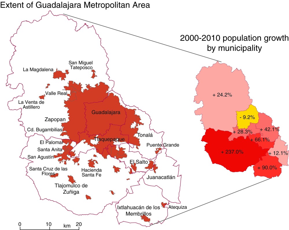
Counter-urbanization is the movement of city dwellers into smaller settlements in the surrounding countryside. With time, some of these smaller settlements are eventually engulfed by the spreading city. The precise boundaries of large metropolitan areas such as the GMA are therefore subject to almost constant change. The map below shows the population change for Guadalajara and its surrounding municipalities for the period 2000-2010.

Guadalajara Metropolitan Area
Population change in the Guadalajara Metropolitan Area, 2000-2010. Click to enlarge.

Note, first, that the population of Guadalajara proper (the municipality of that name) has actually declined significantly since 2000, from 1,647,720 to 1,494,134.

The city is not bounded by the municipal boundary, but spreads into several adjoining municipalities (see map), all of which have experienced population growth between 2000 and 2010. The municipality of Tlaquepaque was already “built up”, even prior to 2000, and its population has risen only slowly since that date. The slowest rate of growth (excluding the “negative growth” of Guadalajara) is in Zapopan; this is a complete change from 30 years ago when Zapopan was growing very rapidly as Guadalajara expanded westwards.

In the 1980s and 1990s, Guadalajara also spread into Tonalá and El Salto. El Salto, relatively close to Guadalajara’s international airport, and close to the main Guadalajara-Mexico City highway, is the heart of a major industrial corridor.  Its main focus in recent years has been on high-tech firms; the region is often referred to as “Mexico’s Silicon Valley”. Firms with manufacturing and/or assembly plants in or close to El Salto include Hewlett-Packard, IBM, General Electric, Intel, Hitachi, Siemens, Flextronics and Solectron. The El Salto area has seen moderate growth over the last ten years.

By far the most dramatic rates of growth for 2000-2010 occurred in Ixtlahuacán de los Membrillos. and in Tlajomulco de Zuñiga, which more than tripled its population in just ten years, from 123,220 to 416,552. Tlajomulco is a very old settlement indeed, with considerable historical importance. The spread of Guadalajara’s suburbs into the northern part of Tlajomulco has been astonishingly rapid, and represents a classic case of the process of suburbanization. Meanwhile, the population of the long-established settlement of Tlajomulco (further south in the eponymous municipality) has also risen rapidly as some urban dwellers choose, in the process of counter-urbanization, to live slightly outside the main urban sprawl of Guadalajara. The counter-urban movement is strongest in the settlements relatively close to the city, but now extends at least 50 km to the south, to the villages on the northern shore of Lake Chapala.

What will 2010-2020 bring? There are few signs that the building boom along the southern edge of Guadalajara Metropolitan Area is going to come to a halt any time soon. The state of Jalisco plans to construct an “outer ring road” south of the city. The planned route passes very close to the settlement of Tlajomulco. It is surely only a question of time before Tlajomulco, and various other small towns and villages, are swallowed up by the continuing expansion of Mexico’s second largest city.

More ground cracks appearing in Mexico City and the Valley of Mexico

 Mexico's geography in the Press  Comments Off on More ground cracks appearing in Mexico City and the Valley of Mexico
Jan 192011
 

The continued sinking of some parts of Mexico City in response to the over-extraction of water from underground aquifers, and consequent shrinking of the subsoil, has resulted in dozens of cracks in recent years. As noted in a previous post – Why are some parts of Mexico City sinking into the old lakebed? – some buildings in Mexico City have dropped more than seven meters (23 ft) since 1891.

According to Gabriel Auvinet Guichard, a researcher at the Engineering Institute of the National University (UNAM), cracks are becoming increasingly frequent. The largest cracks are up to 22 meters (72 feet) deep and 30 meters long. The cracks damage buildings and infrastructure (especially roads and water pipes), and have alarmed residents in some areas in the city.

Auvinet’s team at UNAM’s Geoinformatics Laboratory is compiling a database of all known cracks. They plan to produce maps showing the incidence, location and origin of the cracks to help construction companies meet building regulations. The database has records of 380 fissures at present, but is still far from complete.

Some areas in the Valley of Mexico are much more prone to the earth movements leading to cracks than others. The areas with a high incidence of cracks include Iztapalapa, Chalco, Xochimilco, Xalostoc and Vallejo (see map).

Mexico City cracks map

Locations in Valley of Mexico with high incidence of ground cracks. Cartography: Tony Burton; all rights reserved.

Chapter 23 of Geo-Mexico: the geography and dynamics of modern Mexico looks at urban issues, problems and trends. To preview more parts of the book, click here and use amazon.com’s “Look Inside” feature.

Two major aqueducts in the Lerma-Chapala basin

 Mexico's geography in the Press  Comments Off on Two major aqueducts in the Lerma-Chapala basin
Jan 152011
 

Two major new aqueducts will help to ensure reliable water supplies for Guadalajara and León, two rapidly growing cities in the Lerma-Chapala basin.

SIAPA (Sistema Intermunicipal de Agua Potable y Alcantarillado) is the acronym for the water supply system for the city of Guadalajara, Mexico’s second largest metropolitan area (population: 4.4 million). About 60% of Guadalajara’s potable water comes from Lake Chapala, the country’s largest natural lake, via an aqueduct. According to SIAPA Director José Luis Hernández Amaya, this existing aqueduct, built more than 20 years ago, is now inadequate. SIAPA now has construction permits in place to build a second aqueduct supplying water to the city from the lake. The plans for the second aqueduct have been approved by both state and federal regulatory bodies (the Comisión Estatal del Agua and the Comisión Nacional del Agua (Conagua) respectively).

All parties agree that boosting the amount of available water is essential for a city growing as rapidly as Guadalajara. The new aqueduct, likely to cost 2,000 million pesos, will enable the city to undertake maintenance as needed on the pumping stations and channels of both systems. Undertaking maintenance on the existing system without opening a parallel channel would involve cutting off the water supply for up to 60% of Guadalajara’s population for several days.

A new aqueduct is also planned for the city of León. According to recent press reports, the El Zapotillo dam on the Río Verde is about 21% complete. The resulting reservoir will guarantee adequate water supply for León (population: 1.6 million), and reduce its dependence on groundwater abstraction. Tenders are now being accepted for the construction of a 139-km-long aqueduct from El Zapotillo to join León’s potable water system, together with two pumping stations and a water purification plant.

The new reservoir and aqueduct should ensure that León’s water demands are met for between 25 and 30 years. In addition to León, several other municipalities will also benefit from an improved water supply, including Jalostotitlán, San Miguel el Alto, Encarnación de Díaz, San Juan de los Lagos and Lagos de Moreno.

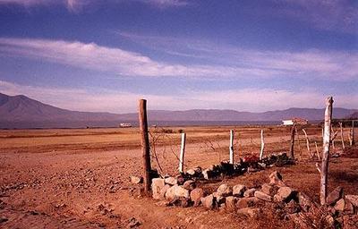
Lake Chapala in 2002

Lake Chapala in 2002, more like a desert than a lake. The lake has since recovered.

Neither plan is without its critics. Activists at Lake Chapala are concerned that supplying more water from the lake to Guadalajara will return the lake to the precarious state it was in during the 1990s. Opponents to El Zapatillo claim that the main demand for water in León is from the new industrial estates and leather tanning plants, and that supplying them with more water will only lead to further serious contamination and even more wastage of the valuable resource.

Rivers, reservoirs and water-related issues are discussed in chapters 6 and 7 of Geo-Mexico: the geography and dynamics of modern Mexico. Ask your library to buy a copy of this handy reference guide to all aspects of Mexico’s geography today! Better yet, order your own copy…

Ciudad Juárez faces economic fallout from the effects of the war on drugs

 Other  Comments Off on Ciudad Juárez faces economic fallout from the effects of the war on drugs
Jan 142011
 

Ciudad Juárez (2010 population: 1.3 million) is regularly in the news for all the wrong reasons. Many factors have combined to increase the insecurity (economic and social) of the city in recent years. They include:

  • the 2008-2010 recession in the USA
  • the ready availability of guns, mainly introduced illegally into Mexico from the USA
  • violence associated with the Juárez cartel in its efforts to control this international drug-smuggling gateway
  • “fund-raising” by the Juárez cartel, which includes the payment of protection money by local businesses, as many as 50% of which are thought to comply with cartel demands
  • violence between members of competing drug gangs
Poster advertising event in Plaza de las Americas, Cd. Juárez

Poster advertising event in Plaza de las Americas, Cd. Juárez

One particular commercial zone has been particularly badly hit. The Pronaf (Programa Nacional de la Frontera) zone is a commercial area in the northern part of Ciudad Juárez, centered on the Plaza de las Americas shopping center, immediately south of the Córdova-Américas International Bridge. The zone offers a mix of restaurants, stores, nightclubs, money exchange outlets, pharmacies and dental offices and even a museum. The customers for the businesses in this area are mainly US tourists and the many daily commuters across the border.

The result of increased levels of violence and unrest is that an estimated 60% of the 400 or so businesses that were open prior to 2008 in the Pronaf zone have now closed. This has caused a large number of job losses, exacerbating the economic difficulties already faced by hundreds of families.

Map of Pronaf zone

Related post about drug cartels in Mexico

Chapters 21 and 22 of Geo-Mexico: the geography and dynamics of modern Mexico analyze Mexico’s 500-year transition to an urban society and the internal geography of Mexico’s cities. Chapter 23 looks at urban issues, problems and trends. An overview of the geography of drug trafficking in Mexico forms part of chapter 20. To preview more parts of the book, click here and use amazon.com’s “Look Inside” feature; buy your copy today!

New aqueduct should guarantee water supply for the city of Hermosillo

 Mexico's geography in the Press  Comments Off on New aqueduct should guarantee water supply for the city of Hermosillo
Jan 082011
 

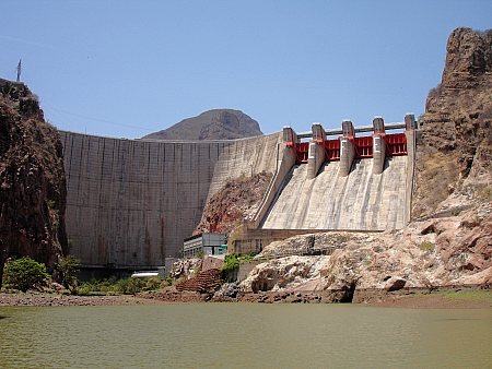
According to press reports, construction is underway of the “Independence Aqueduct” which will carry water from the Plutarco Elías Calles reservoir on the Yaqui River, in southern Sonora, to Hermosillo, the state’s capital city. The reservoir is the 11th largest in Mexico with a capacity of 2,925 million cubic meters.

Javier Gándara Magaña, the mayor of Hermosillo (population 780,000), expects the 150-km-long aqueduct to be functioning by 2012 though he has warned residents that water brought from the reservoir (commonly known as El Novillo) will be more expensive than that from existing sources. City authorities plan to have installed water meters in every dwelling prior to the completion of the aqueduct.

novillo dam sonora

Curtain of El Novillo dam, Sonora

The aqueduct will supply 75 million cubic meters a year to the city, and represents a long-awaited, and long-term, solution to the water problems faced by Hermosillo, which is located in one of the driest regions of the country. At a later stage, the reservoir will also supply 500 million cubic meters a year to the municipality of Cajeme, in the northwest of the state.

Construction of the aqueduct is opposed by many members of the indigenous Yaqui communities and by agricultural producers farming the Yaqui Valley in the south of Sonora who claim that diverting water to Hermosillo will jeopardize the long-term water security for their operations.

Rivers, reservoirs and water-related issues are discussed in chapters 6 and 7 of Geo-Mexico: the geography and dynamics of modern Mexico. Ask your library to buy a copy of this handy reference guide to all aspects of Mexico’s geography today! Better yet, order your own copy…

Mexico’s major metropolitan areas and cities, 2010

 Updates to Geo-Mexico  Comments Off on Mexico’s major metropolitan areas and cities, 2010
Dec 092010
 

The table shows the population figures for Mexico’s 14 largest metropolitan areas, according to the preliminary results of the 2010 census. Mexico currently has 11 metropolitan areas with a population in excess of one million inhabitants. Three other cities have over 900,000 inhabitants, and look set to join the million-plus club within the next few years. A further seven cities—Saltillo, Chihuahua, Acapulco, Morelia, Cuernavaca,Tampico and Veracruz—have populations between 800,000 and 900,000.

1Mexico City (Valley of Mexico)20,137,152
2Guadalajara4,434,252
3Monterrey4,080,329
4Puebla-Tlaxcala2,668,347
5Toluca1,846,602
6Tijuana1,751,302
7León1,609,717
8Cd. Juárez1,328,017
9Torreón-Gómez Palacio (La Laguna)1, 215,993
10Querétaro1,097,028
11San Luis Potosí1,040,822
12Mérida970,495
13Mexicali936,145
14Aguascalientes932,298

Chapters 21 and 22 of Geo-Mexico: the geography and dynamics of modern Mexico analyze Mexico’s 500-year transition to an urban society and the internal geography of Mexico’s cities. Chapter 23 looks at urban issues, problems and trends. To preview more parts of the book, click here and use amazon.com’s “Look Inside” feature; buy your copy today!

Subsidence incident leads to demolition of 31 homes in the State of Mexico

 Mexico's geography in the Press  Comments Off on Subsidence incident leads to demolition of 31 homes in the State of Mexico
Nov 302010
 

Thirty-one homes have been demolished due to structural damage resulting from subsidence in the colonia Benito Juárez. The subsidence, on 28 October 2010, occurred close to the Neza II garbage tip and affected more than 200 homes in total.

Temporary accommodation has been found for the families affected, who will have their rents of up to 2,000 pesos a month paid for the first six months. The compensation to be paid to the affected families from government coffers is still being decided.

Geologists and engineers from the Universidad Nacional Autónoma de Mexico (UNAM) y el Instituto Politécnico Nacional (IPN), are currently assessing the risks of alternative sites for rebuilding the 31 homes. Several areas of Nezahualcóyotl are known to be vulnerable to subsidence or to the sudden appearance of surface cracks (superficial faults).

The subsidence is presumed to have occurred because of the filtration of liquids from the Neza II tip through the subsoil, though precise details are still being investigated. To prevent further problems in the area, pipes are being installed to channel all liquid residues away from homes, and vents are being placed to allow the escape of gases emanating from within the garbage tip.

The three settlements of Nezahualcóyotl, Chimalhuacán and Los Reyes La Paz add about 1,000 tons of garbage daily to the Neza II tip. Authorities are now planning to close the tip completely by the end of November 2010.

Elsewhere in Nezahualcóyotl, the structural integrity of a shopping center and sports complex located near the Neza I tip are also being investigated.

The fact that subsidence occurs far more frequently in the eastern part of Mexico City (including Nezahualcóyotl) than elsewhere does not indicate that the solutions must be local. Ramón Aguirre, the director of Mexico City’s Water System (Sistema de Aguas de la Ciudad de México), has repeatedly emphasized the importance of looking at Mexico City’s potable water and drainage problems in the context of the entire metropolitan area (which extends well beyond the boundary of the Federal District). Aguirre fears that climate change and further over-exploitation of the aquifers, which Mexico City shares with the State of México, will only lead to more problems of water supply and more cases of subsidence.

Chapter 23 of Geo-Mexico: the geography and dynamics of modern Mexico looks at urban issues, problems and trends. To preview more parts of the book, click here and use amazon.com’s “Look Inside” feature.

The nondescript city of Zitácuaro, Michoacán, is the unhappy star of a New Yorker article

 Mexico's geography in the Press  Comments Off on The nondescript city of Zitácuaro, Michoacán, is the unhappy star of a New Yorker article
Nov 132010
 

The city of Zitácuaro in the state of Michoacán had played an important part in Mexican history (hence its full official name of Heróica Zitácuaro) but was largely ignored by tourists until the early 1980s. Things changed, and tourists started coming, when the locations of the Monarch butterfly overwintering sites were first published. The Monarchs had been undertaking their amazing annual migration from Canada and the USA to the rugged mountains close to Zitácuaro for hundreds, possibly thousands of years, but it was only in the early 1980s when articles in newspapers and science journals first provided locational details.

The Monarch butterflies have since become one of the major ecotourist attractions in this part of Mexico. On a single day in February, more than 5,000 tourists enter the main Monarch reserve El Rosario, accessed from either Angangueo or Ocampo, about 40 minutes driving time from Zitácuaro. Hotels in this area have done well out of the annual November-March “butterfly season”. Indeed, the demand led to the construction of several new hotels in the area, some of them more than large enough to handle tourist groups arriving by the coachload.

In 1980, I began leading regular fieldtrips to Zitácuaro and its surrounds, the major attractions being wonderful scenery and an interesting mix of settlement types, covering everything from 4-hut hamlets to the medium-sized city of Zitácuaro, which had a population at the time of about 100,000.  Over the years, I’ve watched Zitácuaro grow into a much larger city. When the bypass was first built, and federal Highway 15 rerouted around the town instead of along Avenida Revolución, it was ignored by most motorists, who preferred to drive through the city, often stopping for gas or food before continuing their journey. Within a few years, services had begun to spring up, as if by magic, alongside the bypass. Today, the city has spread well beyond the confines of the bypass.

In recent years, violence related to drug trafficking has reached the city. This is perhaps somewhat surprising, given its location far from the USA border, and far from the traditional territories of the main drug cartels. But, as we saw in an earlier post (The geography of drug trafficking in Mexico),  Zitácuaro is very close to the edge of the “territories in dispute” immediately to the west of Mexico City. Violence in these areas is growing as rival groups seek to control the lucrative drug trade. The La Familia crime group is responsible for most drug-related violence in Michoacán.

An article in the New Yorker earlier this year described in detail how La Familia has increasingly threatened the rule of law in  Zitácuaro. The article serves as a good introduction to how an ordinary Mexican city – in this case Zitácuaro – can be dramatically changed by a committed and ruthless criminal group.

An overview of the geography of drug trafficking in Mexico forms part of chapter 20 of Geo-Mexico: the geography and dynamics of modern Mexico. Buy your copy today!

Related post about drug cartels in Mexico:

Nov 092010
 

In an earlier post, we looked at why ground subsidence has become such as serious problem in Mexico City.

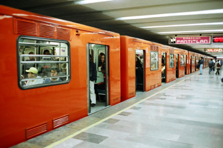
The uneven subsidence poses a major challenge for engineering projects such as constructing (and maintaining) the city’s metro system.Mexico City metroThe Mexico City metro has 11 lines linking 175 stations, with a total length of 201 km (125 miles); an additional line is under construction. The metro is used by 5 million passengers a day. Some parts of the system are overground, but 56% of the network is underground. The deepest station is 35 m below street level. The Mexico City metro is the 7th most widely used in the world, after the metros in Tokyo, Moscow, Seoul, New York, Paris and Beijing.

  • many archaeological finds, including a pyramid, were made during the excavation required for Mexico City’s metro
  • Pino Suárez station was built around an ancient pyramid unearthed during metro construction
  • stations are named, but are also identified by simple glyph-like logos designed for easy use by people who have difficulty reading or writing
  • a single trip between any two stations on the network costs $3 pesos (about 25 cents US).; the metro is free for the elderly and physically-challenged
  • during peak hours, the Metro reserves some carriages for women and children only (no men)
  • almost all Mexico City metro cars run on rubber tires, making for a smooth, quiet ride

When the first line was built in 1969, one of the strategies adopted by engineers to limit damage from subsequent subsidence was apparently to build the metro tunnels and stations in such a way that their total weight was very similar to the weight of the mud and sediments removed during construction. Presumably, if the weights were identical, at least the tunnels would be likely to remain in the same relative positions over time, even if the subsoil contracted and sank. To a large extent, the engineers were successful, and the metro has experienced  amazingly few structural problems in its 41 years of operation. In the devastating 1985 earthquakes, Mexico City’s metro system sustained no serious damage despite the widespread destruction and loss of life above ground.

Mexico City’s metro network is administered by the Metro Transportation System (Sistema de Transporte Colectivo Metro, STCM). STCM ackowledges several recent problems related to small-scale earth movements on five of its eleven lines: Lines 4, 5, 9, A and B. For example, the maximum permitted velocities for metro trains were reduced for the section of Line A between Pantitlán and La Paz while repairs costing 36 million dollars were completed. Even as STCM undertakes the necessary repair work, it is starting to install a state-of-the-art, 1.6-million-dollar fiber-optic monitoring system which will eventually cover the entire network.  The system enables the “real time” detection (with live video feeds) of any subsidence, fissures, inundations or related issues.

Useful link:

Key question, based on the map:

  • Why does the metro system have a much higher density in eastern and southern Mexico City than in the northern and western parts of the city?

Chapters 21 and 22 of Geo-Mexico: the geography and dynamics of modern Mexico analyze Mexico’s 500-year transition to an urban society and the internal geography of Mexico’s cities. Chapter 23 looks at urban issues, problems and trends. To preview more parts of the book, click here and use amazon.com’s “Look Inside” feature; buy your copy today!

The distribution of retail activities in the city of Zitácuaro, Michoácan, Mexico

 Excerpts from Geo-Mexico  Comments Off on The distribution of retail activities in the city of Zitácuaro, Michoácan, Mexico
Nov 022010
 

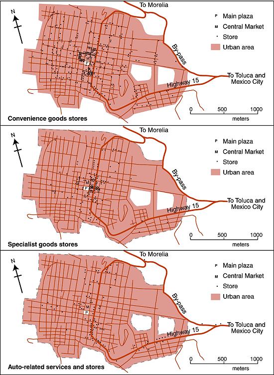
The maps below show the distribution in 1980 of three distinct types of commercial establishments in the mid-sized city of Zitácuaro in Michoacán.

Map of retail activities in Zitácuaro, Michoacán

Retail activities in Zitácuaro, Michoacán. Color version of Figure 22.3 of Geo-Mexico: the geography and dynamics of modern Mexico. All rights reserved.

Founded hundreds of years earlier, the city grew spontaneously, almost organically, with little planning; its population by 1980 was 100,000. Cars were not a necessity. The residents of Zitácuaro did not have to walk far to purchase their basic daily shopping needs. Convenience stores (top map) existed in every  neighborhood. Many (145 out of 393) were genuine “corner stores”, strategically located at street intersections. On average, each convenience store served about  250 residents.

More specialist stores (middle map), selling so-called “shopping goods” such as clothes and furniture, had a very different distribution. A few were located in  residential areas, but most were concentrated in the heavily trafficked central area of the city, in the narrow streets close to the main plaza or zócalo, west of the main highway.

By 1980, a bypass had been opened enabling through traffic to avoid the main congested highway through the center of the city. However, the distribution of specialist stores does not appear to show any close connection to either the old highway or the new bypass.

This contrasts with the distribution of stores connected to auto services (gas stations, auto parts, tire repairs, mechanics) where the preferred locations in 1980 were close to the main highway (bottom map). In the succeeding years, this distribution has changed somewhat. Many of these services have now relocated to the by-pass to better serve the passing traffic.

This post is an excerpt from Geo-Mexico: the geography and dynamics of modern Mexico. Chapters 21 and 22 of Geo-Mexico analyze Mexico’s 500-year transition to an urban society and the internal geography of Mexico’s cities. Chapter 23 looks at urban issues, problems and trends. To preview more parts of the book, click here and use amazon.com’s “Look Inside” feature. Buy your copy today!

Sep 062010
 

Bike riding is quite a common recreational activity in Mexico, as well as being many people’s chosen means of transport to work.

In recent years, an increasing number of cities have started regular bike festivals or other events. The Festival de Bicicleta in Xalapa, the state capital of Vercaruz, is just one example.

Back in 1972, in Mexico City, famous Belgian cyclist Eddy Merckx, considered by many to be the greatest cyclist in the history of the sport, smashed the world one-hour distance record by pedaling 49.431 km (30.715 miles). He simultaneously established new 10 km (6.2 miles) and 20 km records by covering 10 km in 11 minutes 53.2 secs and 20 km in 24 minutes 6.8 secs. One curiosity of this achievement is that contemporary ads for Windsor bikes purport to claim that he was riding a Windsor bike when he smashed the record, whereas he was actually riding an Italian bike! Merckx’s distance record stood for more than a decade before being broken, also in Mexico City, by Francesco Moser.

Mexico City is catching up with the craze for bike riding, too. It sees bikes as one way to reduce air pollution. About 30 km ( miles) of downtown streets, including the 8-lane Avenida Reforma, are closed to powered vehicles on Sunday mornings, to provide unhindered access for pedal bikes, walkers, and wheelchairs.

Earlier this year, the city began a bike rental system, Ecobici. More than 1,000 bikes were distributed between 85 specially-designed bike stations, spaced around the city center. Users purchase swipe cards which allow them to access a bike. After the trip, the bikes can be returned to any of the stations. City officials anticipate 24,000 riders using the system by the end of the year.

Stamp of Bike exports

As the postage stamp suggests, Mexico exports bikes, mainly to the USA. The export market has declined, however, in the past decade as several manufacturers who used to assemble bikes in Mexico have moved their operations to China. Firms which have relocated their operations away from Mexico include Huffy (formerly in Nuevo Laredo), Windzy (Monterrey), Brunswick (Ojinaga) and SRAM.

The website of the National Association of Bicycle Manufacturers claims that its 14 member companies produce about 3 million bikes a year and employ, between them, 4,000 workers.

The 14 bike manufacturers listed are:

  • Bicicletas Cinelli – Santa Catarina, Nuevo León
  • Nahel – Durango, Durango
  • Goray – Torreón, Coahuila
  • Grupo Veloci – Zapopan, Jalisco
  • Rebimo de Guadalajara – Zapopan, Jalisco
  • Biciclo – San Luis Potosí
  • Bicicletas Mercurio, Mérida, Yucatá and San Luis Potosí (they acquired the famous Acer-Mex Windsor brand in 2001)
  • Bimex – Mexico City
  • BR – Mexico City
  • Magistroni – Mexico City
  • Benotto (primarily a distributor) – Mexico City
  • Grupo Oriental – Mexico City
  • Bicicletas Ozeki – Atizapan de Zaragoza, State of México
  • Bicileyca – Yauhquemehcan, Tlaxcala

Q. Is there any pattern to the distribution of bike manufacturers in Mexico? Try plotting the locations mentioned on a map of Mexico to see if any pattern emerges.

Q. What factors do you think bicycle manufacturers must take into account when deciding where to locate?

Mexico’s manufacturing industry is discussed in chapter 16 of  Geo-Mexico: the geography and dynamics of modern Mexico. Mexico’s transportation system is discussed in chapter 17, and its exports in chapter 20.

Ask your library to buy a copy of this handy reference guide to all aspects of Mexico’s geography today! Better yet, order your own copy…

The distinctive sounds of Mexico’s towns and cities

 Mexico's geography in the Press, Teaching ideas  Comments Off on The distinctive sounds of Mexico’s towns and cities
Aug 312010
 

Geographers have long been interested in the distinctive contribution of sounds to landscapes, especially urban landscapes. Some sounds are associated with pleasure, some with danger, others with impatience. The soundscapes of cities have become a legitimate area of study.

Early work tended to focus on traffic noise or on identifying areas where ambient noise from industry or other activities exceeded a comfortable threshold volume.

Soundscapes vary from rural areas to urban areas, and from one region to another. Mexico’s urban soundscapes are among the most distinctive on the planet, and this week has been declared National Sound Week by the federal government. Several “sound walks” have been organized in major cities.

As a USA Today article points out, all sounds contain a message. For example, “A series of four notes on a pan flute means the scissor-sharpening man is in the neighborhood. A ringing hand bell means the garbage truck is here” and so on.

The traffic whistles made by police are an important subset of the sounds in any Mexican town or city. They have a mini-language of their own, explored in this MexConnect article: Did you know? Different traffic whistles in Mexico mean different things.

Fieldwork idea: Portable sound meters make it relatively easy to compile a map showing the sound levels (measured in decibels) around particular sources of sound, whether periodic in occurrence (such as vehicles at a traffic light or the crowd in a sports stadium) or more or less continuous (like the hum of wind turbines or the noise of a factory).

Once a map has been compiled, analyze any patterns you can identify. Studies of urban soundscapes are not only of academic value, but have an important role in city planning as well. For example,

  • Do tall buildings mask the loudest sounds, or do they funnel it towards the listener?
  • Does the sound level vary depending on the quantity of vegetation between the sound source and the listener?
  • Which kinds of vegetation are most effective in masking sounds?
  • Is east-west traffic louder than north-south traffic?

The revitalization of Mexico City’s historic downtown core.

 Excerpts from Geo-Mexico  Comments Off on The revitalization of Mexico City’s historic downtown core.
Aug 172010
 

The Historic Center of Mexico City was originally founded in 1524 atop the Aztec capital of Tenochititlan. The Historic Center declined considerably during the 20th century. The government froze rents in the 1940s and they stayed frozen until 1998. With constant inflation, the real price of rents declined to almost nothing.

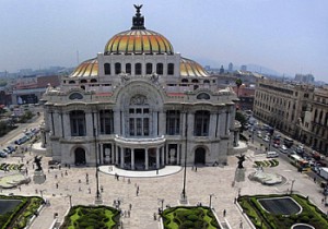
Bellas Artes opera house, Mexico CityWithout meaningful rental incomes, landlords abandoned or stopped maintaining their properties. Buildings and neighborhoods decayed. Once-fancy communities became slums. Many wealthy and middle class residents as well as commercial establishments moved out to suburbs. The National University (UNAM) moved to a new purpose-built campus in the south.

The tragic earthquakes in September 1985, the first measuring 8.1 on the Richter scale, hit many badly maintained downtown areas particularly hard. More and more residential buildings were abandoned as insecurity, pollution and decay set in, aided and abetted by the sinking ground levels due to aquifer depletion.

At the start of the 21st century, a government-private sector Historic Center Trust was formed to buy and systematically rehabilitate dozens of centuries-old buildings and breathe new life into the city center. Investment in the revitalization effort was over $500 million and has created 15,000 new jobs.

Drainage and water systems were replaced. Electric and telephone cables were buried below ground. The facades of more than 500 buildings on 13 streets were carefully restored. Streets were repaved and pedestrianized. Plazas came back to life; new museums sprung up; street vendors were relocated. Cafes and restaurants opened, giving new focal points for residents and tourists alike.

If you have enjoyed this brief excerpt from chapter 23 of Geo-Mexico: the geography and dynamics of modern Mexico please consider purchasing your own copy of the book. Chapters 21 and 22 analyze Mexico’s 500-year transition to an urban society and the internal geography of Mexico’s cities. Chapter 23 looks at urban issues, problems and trends. To preview more parts of the book, click here and use amazon.com’s “Look Inside” feature

Air quality improving in Mexico City but not in Monterrey

 Mexico's geography in the Press, Other  Comments Off on Air quality improving in Mexico City but not in Monterrey
Aug 102010
 

A recent short piece in The Economist, “A breath of fresh air” (31 July 2010) echoes Geo-Mexico’s contention that air quality has been improving in Mexico City in recent years, but declining in other large cities, especially Monterrey.

The improving air quality in Mexico City is attributed to:

  • relocation of heavy industry away from the city
  • closure of the Azcapotzalco oil refinery (1991); part of this area is now a public park
  • vehicle emissions standards, and enforcement
  • “Día sin coche” (Day without a car) policy for all but the newest vehicles
  • improvements to public transport, such as introducing Metrobus; starting in 2011, taxi owners have incentives to use hybrid or electric vehicles
  • on-going, effective monitoring of air quality since the mid 1980s
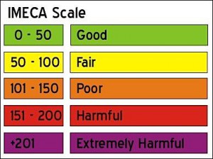
The IMECA scale for urban air quality

The IMECA scale for urban air quality

Air quality still exceeds environmental norms in Mexico City many days each year, but far fewer than during the late 1980s and early 1990s when air pollution was at its peak. Even low-level ozone measurements are showing improvement. Ironically, ozone in the lower atmosphere rose immediately after the introduction of a new unleaded gasoline, designed to  ensure that the major source of brain-damaging lead pollution was removed. The new gasoline, it emerged, simply traded one serious pollutant for another.

Latest pollution values for Mexico City.

Mexico’s other big cities still face enormous challenges with regards to air pollution. Monterrey’s air regularly has very high concentrations of microparticulates (PM10); the levels now exceed Mexico City’s peak readings from twenty years ago.  The air in Guadalajara is improving, but not as rapidly as in Mexico City.

Geo-Mexico: the geography and dynamics of modern Mexico examines the trends in air quality (ozone, microparticulates and carbon monoxide) for Mexico’s three largest cities and also asks whether the air pollution from maquiladora plants in Ciudad Juárez raises public health issues.

Ask your library to buy a copy of this handy reference guide to all aspects of Mexico’s geography today! Better yet, order your own copy…

Previous post on this topic: Mexico City air quality continues to improve

Aug 062010
 

The rapid spatial expansion of Mexico City is not slowing down in the 21st century but accelerating. The main stimulus of this sprawl is income growth, which leads to widespread ownership of private automobiles and the desire of Mexican families to own homes. The number of automobiles in Metropolitan Mexico City (ZMCM) is approaching 10 million, almost double the number in 2000. Most households have access to a private car, many have several cars. Automobiles are responsible for nearly half of all trips. While the 2008–2009 economic downturn dramatically reduced new car purchases, the market has picked up significantly in 2010.

Map of Mexico City urban system

Map of Mexico City urban system. Click to enlarge. All rights reserved.

New suburban residential developments for all income levels now stretch up to 40 km from the Zócalo (the main plaza in Mexico City’s center).  Some developers sell undeveloped lots; others build family homes. Most of these new developments are in gated communities and are focused on car-owning buyers.

A case can be made that Mexico City is beginning to merge with surrounding urban areas (see map) into a “super city” or megalopolis, with a total population of about 30 million.

The eastern border of the Toluca Metropolitan Area (population 1.6 million) is the Federal District. The Cuernavaca urban area (population 788,000) is only about 20 minutes south by toll road. The western edge of Metropolitan Puebla-Tlaxcala (population 2.1 million) is only about 30 minutes from the eastern edge of Greater Mexico City. Pachuca (population 278,000) is only about 30 minutes north.

A megalopolis is one possible future scenario for Mexico City.

If you have enjoyed this brief excerpt from chapter 23 of Geo-Mexico: the geography and dynamics of modern Mexico please consider purchasing your own copy of the book. Chapters 21 and 22 analyze Mexico’s 500-year transition to an urban society and the internal geography of Mexico’s cities. Chapter 23 looks at urban issues, problems and trends. To preview more parts of the book, click here and use amazon.com’s “Look Inside” feature.

Jul 232010
 

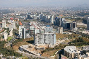
Santa Fe, in upscale western Mexico City is one example of the many new developments being built on the urban periphery in Mexico.

Santa Fe, a subsidiary CBD in Mexico City

Santa Fe has become a subsidiary CBD in Mexico City. Photo: Oscar Ruiz

The plan for the Santa Fe complex called for private sector financed office towers, a gigantic retail mall, high income housing, park areas, as well as schools and universities. Construction was halted briefly by the 1994–95 economic crises, but soon resumed at full speed. Today Santa Fe has numerous skyscraping office towers, over one eighth of the Federal District’s total office space, about 70,000 employees, four universities with 13,500 students, over 4300 residents, and one of the largest retail malls in Latin America.

Santa Fe is essentially an island that is only accessible by private car; public transport is relatively limited.

Unfortunately, it has not fully lived up to expectations. The preponderance of cars, mostly with a driver and no passengers, has led to severe traffic jams. Perhaps related to this, the vacancy rate of office space is about 25%. Furthermore, even with eight million visitors a year, the gigantic Santa Fe shopping mall is not as heavily utilized as competing malls in the area.

How many of the shoppers in Santa Fe mall or students attending classes realize that they are on top of what was once one of the biggest garbage dumps in Mexico City? Prior to its development into high-end real estate, much of this area had been quarried for sand, and the resulting holes  used as a landfill site for household and industrial waste. Some of the structural problems reported in buildings in Santa Fe may well be due to the settling of these less than savory foundations.

(Our sincere thanks to Fatimah Araneta for improving this account)

If you have enjoyed this brief excerpt from chapter 23  of Geo-Mexico: the geography and dynamics of modern Mexico please consider purchasing your own copy of the book. Chapters 21 and 22 analyze Mexico’s 500-year transition to an urban society and the internal geography of Mexico’s cities. Chapter 23 looks at urban issues, problems and trends. To preview more parts of the book, click here and use amazon’s “Look Inside” feature.

A case study of low-income housing on the urban periphery

 Excerpts from Geo-Mexico  Comments Off on A case study of low-income housing on the urban periphery
Jul 132010
 

A shortage of affordable housing is a persistent problem in large Mexican cities. In response, new, subsidized lower income housing developments are being built on the periphery of Mexico City, Guadalajara, Monterrey, and other metropolitan areas.

Sprawling Mexico City - "El Monstruo"

Sprawling Mexico City - "El Monstruo"

Though most working families can afford the down payment and monthly payments for these subsidized housing units, these expenses leave little extra for food, clothing, utility bills, commuting, and health care. Even these subsidized housing units provide a car parking place because virtually all Mexican families aspire to own their own automobile. The case study which follows, of the Hernández family, illustrates the situation.

Carlos Hernández, his spouse, mother-in-law, and two daughters are happy with their house in a new housing development in Zumpango, about 40 km (25 mi) north of the Mexico City Zócalo. The government-backed mortgage on the tiny (30 square meters – 323 square feet, about the size of a two-car garage), 15,700-dollar, one-bedroom house, is 100 dollars a month. Hernández must spend another $110 a month for his daily five hour commute by colectivo (mini bus), bus, and metro (subway) to his $350 a month maintenance job in the capital. This leaves only $140 a month for all other expenses such as food, utilities, installment payments on furniture and appliances, health care, clothing, schooling, etc. To help make ends meet, his spouse, Edith, runs an informal convenience store out of the front of the house.

The house is very crowded; the kitchen table is brought inside only at mealtimes. Carlos and Edith sleep on a foldout couch in the living room. Edith’s mother, Lucía, has the bedroom and the two daughters take turns sleeping with their parents or grandmother. Hernandez is glad he finally owns a house and no longer has to pay rent. His story is repeated tens of thousands of times as hundreds and hundreds of low-income housing developments are being built on the urban periphery.

If you have enjoyed this brief excerpt from chapter 23  of Geo-Mexico: the geography and dynamics of modern Mexico please consider purchasing your own copy of the book. Chapters 21 and 22 analyze Mexico’s 500-year transition to an urban society and the internal geography of Mexico’s cities. Chapter 23 looks at urban issues, problems and trends. To preview more parts of the book, click here and use amazon’s “Look Inside” feature.

Jul 082010
 

Mexico City’s inner city slums date from the regime of Porfirio Díaz (1877–1910) which stimulated rapid railroad expansion and industrialization north and northwest of the city center. The industrial zone expanded out along the rail lines into the areas now known as Azcapotzalco and Gustavo A. Madero.

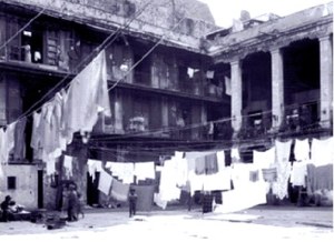
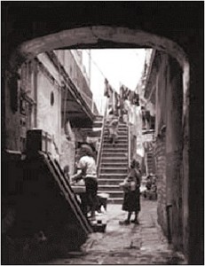
Typical vecindad, Mexico CityWith this expansion, the upper classes sold or abandoned their inner city colonial mansions and moved further west, deliberately avoiding noisy and polluted industrial areas. Their abandoned multi-storied mansions were converted into vecindades, cheap tenements with individual rooms rented to families.

Vecindades, with a shared central court, kitchen and latrines, became Mexico City’s first slums. They encircled the center on the north, east and south; the west side remained upscale. As these eventually became overcrowded, incoming migrants moved into cheap, undesirable housing in the industrial zone or on the urban periphery.

Vecindad, Mexico CityRapid industrialization after World War II brought another massive wave of poor immigrants. They initially headed for the low rent vecindades which had expanded as developers built new tenements using the old vecindades as a model.

Following government-mandated rent control, many investors abandoned the vecindades, depleting an already poor housing stock. Affordable housing emerged as a paramount concern of low-income residents; most were forced into colonias populares either on very steep hillsides or the urban periphery, such as Nezahualcoyotl.

While vecindades are most closely associated with Mexico City, they also emerged in Mexico’s other large cities. About ten percent of Mexico City’s current residents live in vecindades.

Mexico’s cities and towns are analyzed in chapters 21, 22 and 23 of Geo-Mexico: the geography and dynamics of modern Mexico. Buy your copy today!!

Nezahualcoyotl, an irregular settlement which grew into a monster

 Excerpts from Geo-Mexico, Updates to Geo-Mexico  Comments Off on Nezahualcoyotl, an irregular settlement which grew into a monster
Jul 022010
 

Rapid industrialization north of Mexico City after World War II brought a giant wave of immigrants aggravating a serious shortage of low income housing. With the vecindades (inner city slums) severely overcrowded, the only alternative was “irregular housing” or “colonias populares.” These were developed wherever there was vacant land, mostly in the west and north of the city on the dry former lakebed or on very steep slopes. They all followed a development pattern roughly similar to that of Nezahualcoyotl, the largest and best known colonia popular.

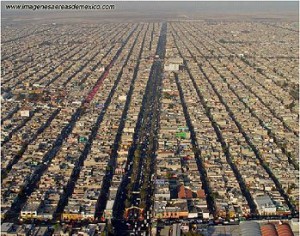
The densely packed housing of Nezahaulcoyotl in all its glory

The densely packed housing of Nezahaulcoyotl in all its glory. Image: imagenesaereasdemexico.com. Follow link at end of post for more Mexico City photos

In the late 1950s, a group of speculators gained de facto possession of roughly 78 square kilometers  (30 square miles) of former lakebed in Nezahualcoyotl just east of the Mexico City airport. They sold nearly 200,000 plots cheaply and on credit, a few dollars down, and a few dollars a month, for 10-20 yrs.

Families bought plots and immediately started to erect shacks. Aside from electricity, which was provided by the national utility, the plots initially lacked basic services such as potable water, sewerage, flood drainage, pavement, schools, etc. Without services, Nezahualcoyotl was illegal under State of Mexico law; but the government tolerated this situation.

The community became an immediate boom town. By 1970, the population was over 600,000, but still over half the area was without paved streets, water supply and drainage. Summer brought floods while the rest of the year it was an arid dust bowl.

Residents became frustrated with the broken promises of the developers, demanded that they be jailed for fraud, and stopped their monthly payments. The feud lasted for years and some developers were actually jailed. Eventually most of the area was “regularized”, meaning that residents got legal deeds and basic services. They continued to improve their houses and communities.

Nezahualcoyotl, the city of dreams

Nezahualcoyotl, the city of dreams

By 1980, the population reached about 1.3 million, making it one of the largest and most densely populated municipalities in the country.

By 2000, Nezahualcoyotl had essentially joined the mainstream. Nearly all residents had electricity and TVs, over 80% had refrigerators, 60% had telephones, nearly one in three had access to an automobile, and almost one in five had a computer. While Nezahualcoyotl has slums, gangs and crime, it also has tree-lined boulevards, parks, a zoo, banks, shopping centers, offices, libraries, hospitals, universities, cinemas, and apartment buildings. It even has a cathedral (since 2000) and an Olympic sports stadium, which hosted some 1986 FIFA World Cup matches. Currently, it is a vital part of metropolitan Mexico City and provides jobs for almost 250,000.

From irregular settlement to massive urban monster; Cd. Nezahualcoyotl has certainly come a long way!

Mexico’s cities and towns are analyzed in chapters 21, 22 and 23 of Geo-Mexico: the geography and dynamics of modern Mexico. Buy your copy today!!

Jun 292010
 

With very rapid growth in the mid-20th century, inner city urban slums could not absorb all the new low income immigrants. The only viable option was so-called “irregular” housing or colonias populares. Irregular housing schemes were initiated by developers who gained ownership of large tracts of contiguous land on the urban periphery. Some of these tracts were illegally obtained ejido properties. Whether ejido or not, the tracts usually consisted of marginal lands, either prone to seasonal flooding or on very steep hillsides.

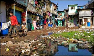
A colonia popular in Mexico

One of Mexico's many "colonias populares"

The land was subdivided into numerous small lots and sold on an installment plan to low-income families, who would construct low cost one room shacks which they called “home.” These neighborhoods were called “irregular” because many residents lacked legal deeds to their lots, their houses did not meet building codes, and they usually lacked important urban services.

Investors could not legally sell building lots without services such as water, drainage, paved streets, electricity and other basic infrastructure. However often investors did little more than mark the services on the property maps and provide “paper” services. Lots with actual services were considerably more expensive and beyond the reach of most of the urban poor. In general, local government tolerated these unserviced and illegal developments, because they helped relieve the low income housing crisis.

Street plan of a "colonia popular"

Street plan of a "colonia popular"

Developers could make fortunes with these housing schemes. In a one square kilometer piece of land they could sell up to 10,000 lots (each averaging 100 square meters, or 1076 square feet). At $200 a lot, this brought them $2 million. Developers often reneged on their promises to provide services, though their plans did at least provided vacant strips of land between lots, which became known as “paper streets”.

In the beginning, many “irregular” communities lacked running water, sewers, drainage, electricity, and public transport. However, eventually the needed services were provided and the residents upgraded their houses. After a decade or two, most of these communities became completely “regularized” with water, sewers, drainage, electricity, telephones, cable TV, retail stores, schools, bus routes, medical clinics, offices, and even movie theaters, shopping centers, and office buildings. In most large Mexican cities, roughly half of all current housing started as “colonias populares”.

Mexico’s urban geography is analyzed in chapters 21, 22 and 23 of Geo-Mexico: the geography and dynamics of modern Mexico. Buy your copy today, and read more about the fascinating history and structure of Mexico’s cities.

The impact of NAFTA on urban growth in Mexico

 Other  Comments Off on The impact of NAFTA on urban growth in Mexico
Jun 192010
 

The North American Free Trade Agreement (NAFTA), signed in 1994, had a significant impact on the pace and pattern of urbanization in Mexico.

NAFTA removed tariffs on imported corn and beans.  Small Mexican producers could not compete with the cheap imports from the USA. As a result, an estimated 1.3 million agricultural jobs in Mexico were lost. Many of those who lost work in rural areas, moved to Mexican cities or to the USA to search for employment. Most of these drifted into the urban informal sector in cities throughout Mexico.

Geo-Mexico, figure 20.2

Geo-Mexico, figure 20.2 All rights reserved.

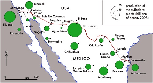
On the plus side, NAFTA created an estimated 500,000 jobs in Mexican manufacturing, mostly maquiladora assembly plants focused on the US market. These plants and their multiplier impacts generated rapid growth in border cities, particularly Ciudad Juárez, Tijuana, Mexicali, Matamoros, Nuevo Laredo, and Reynosa (see map).

Largely as a result of NAFTA, border cities grew faster during the 1990s than most other Mexican cities, essentially reversing the trend that existed during the 1980s. Though after 2000 many of Mexico’s border maquiladora industries moved to lower cost countries, most border cities continued to grow rapidly.

In conclusion, the overall NAFTA impact has strongly stimulated urban growth while fostering rural decline and out-migration.