water | Geo-Mexico, the geography of Mexico

The deepest water-filled sinkhole in the world is in Tamaulipas, Mexico

 Other  Comments Off on The deepest water-filled sinkhole in the world is in Tamaulipas, Mexico
Oct 122016
 

As vertical shafts go, this is a seriously deep one! Long considered to be “bottomless” (because no-one had ever managed to find the floor), we now know it is precisely 335 meters (1099 feet) deep, making it the deepest water-filled sinkhole anywhere on the planet.

The El Zacatón sinkhole is on El Rancho Azufrosa, near the town of Aldama in Tamaulipas in northeast Mexico. The sinkhole or cenote is one of several located in the same area, though recent studies have failed to demonstrate any obvious underground connections between them. The term cenote is a Spanish rendering of the Mayan word d’zonot, “a hole in the ground”. The El Zacatón pit, which is about 110 meters (360 feet) across and roughly circular, contains a deep lake. The water is warm (averaging about 30 degrees C), highly mineralized and has a sulfurous odor. The name El Zacatón comes from the floating islands of grass (zacate) which blow across this lake from one side to the other with the wind.

The Zacatón Sinkhole

The Zacatón Sinkhole

The pit’s depth has attracted serious divers for many years. In 1993, Dr. Ann Kristovich dove to a new women’s world record depth of 169 meters (554 feet). The following year, two American explorers tried to reach the bottom of the sinkhole. Jim Bowden successfully reached a men’s world record depth of 282 meters (925 feet) but still did not touch the bottom. Tragically, his diving partner Sheck Exley died during the attempt.

The mystery of the sinkhole’s depth was finally solved in 2007. A multi-million dollar exploration, mainly funded by NASA, trialled the Deep Phreatic Thermal Explorer (DEPTHX) robot, designed to explore ice-covered Europa, Jupiter’s smallest moon. Partners on the DEPTHX project include Carnegie Mellon University, Southwest Research Institute, Colorado School of Mines, The University of Arizona, and the University of Texas at Austin’s Jackson School of Geosciences. In the words of a NASA press release, The Deep Phreatic Thermal Explorer (DEPTHX) is a 3,300-pound, computerized, underwater vehicle that makes its own decisions. With more than 100 sensors, 36 onboard computers, and 16 thrusters and actuators, it decides where to swim, which samples to collect, and how to get home.

Exploring El Zacatón pit was considered to be an ideal preliminary test of the DEPTHX autonomous robot, which is about the size of a go-kart. The robotic vehicle successfully generated a highly detailed sonar map of the sinkhole, and obtained samples of water and biotic material from the walls, discovering several new phyla of bacteria in the process. Its next challenge is to explore beneath the ice of West Lake Bonney in Antarctica.

At El Zacatón, the sonar study showed that the sinkhole has a total depth of 335 meters: the lake is 319 meters deep at its deepest point, and its surface is 16 meters below the height of the sinkhole’s rim.

Related post:

Sources / Further reading:

Mexico’s geology and landforms are analyzed in chapters 2 and 3 of Geo-Mexico: the geography and dynamics of modern Mexico.  Buy your copy of this book today!

More water meters for Mexico City

 Mexico's geography in the Press, Updates to Geo-Mexico  Comments Off on More water meters for Mexico City
Oct 122015
 

A recent OOSKAnews report says that Mexico City’s water authority (Sacmex) is seeking to purchase 27,835 more water meters that it plans to install in coming months. Sacmex supplies water to around 2 million separate addresses, of which 1.4 million are already metered. The latest purchase is part of Sacmex’s plan to ensure that 100% of connections to the water system are metered. Sacmex’s current budget includes $3.5 million for an additional 40,000 meters.

sacmex

At present, users without a meter pay a fixed bi-monthly tariff based on the building category, and intended type of water use (domestic/industrial/commercial).

Funding for the meters will be part of a $200 million World Bank-supported “Program to Improve the Efficiency of Operating Organizations” (PROME) which has already financed various projects across the country for urban areas with populations over 20,000. Projects already funded by the Progam include more efficient pumps, the updating of user databases with geo-referencing technology, and studies to gauge the robustness of indicators such as water pressure, water quality and leak detection.

Sacmex is also working on other distribution issues. Earlier this year – see Water in Mexico: a human right that is currently subsidized and wasted – Sacmex CEO Ramón Aguirre Diaz said that the agency required $430 million to combat leakages in the system (currently estimated at around 40% of supply), and claimed that a long-term program to fix the problem would be introduced next year.

Related posts:

Water in Mexico: a human right that is currently subsidized and wasted

 Other  Comments Off on Water in Mexico: a human right that is currently subsidized and wasted
Aug 172015
 

Two recent articles in OOSKAnews, a publication dedicated to news in the water industry, have profound implications for Mexico’s water supply situation. The first (10 July 2015) is a report of a meeting in Guanajuato of national water and water treatment specialists (Segundo Encuentro Nacional de Áreas Técnicas  de las Empresas de Agua y Saneamiento de México).

Selected quotes from the report include,

Mexico’s legal framework for water is out of date and does not reflect the country’s current reality…

Nationwide, water users only pay about 20% of the cost of production; 80% of water costs are subsidized, a situation that is not sustainable…

Legal reforms aimed at protecting human rights with regard to water had harmed service providers, who cannot cut off service to customers who fail to pay their bills.”

The report also comments on the on-going El Zapotillo dam project on the Rio Verde in Jalisco state, saying that it,

is a priority for President Enrique Pena Nieto’s administration, despite ongoing delays and legal conflicts. The $1.24 billion dollar project was approved in 2005 and is more than 80% complete. However, residents of Temacapulín, Acasico and Palmarejo have been fighting construction of the dam, which would flood their villages.”

sacmex

The second report focuses on Mexico City and the estimate by Ramón Aguirre Díaz, the head of Mexico City’s Water System (SACMEX), that fixing leaks in the city’s potable water distribution network would cost around US$430 million. This is a huge cost when compared to the system’s annual budget for maintenance and improvement of infrastructure of about US$135 million.

Aguirre claims that 40% of available water is lost because of leaks in the network. SACMEX is launching a program in 2016 to provide a long-term solution to the problem. In a press interview, the official said that, “A city like ours should be able to supply every citizen by producing 26 cubic meters/second, but currently our system requires 30.5 cubic meters/second”.

The sections of the city with the most severe losses are those like Coyoacán and Tlalpan built on the soft sediments of the former lake-bed, as well as those such as Miguel Hidalgo, Cuauhtémoc, and Benito Juárez, where the supply pipes are more than 70 years old. Combined, these areas house over 2.5 million people.

Aguirre also outlined the progress made in bringing reliable access to potable water to all 1.8 million inhabitants of Iztapalapa, one of the poorest and most densely populated sections of the city. Some 72,000 residents in Iztapalapa lack piped water supply to their homes, and therefore have to depend on provision from tanker trucks. Even those who do have access to piped water have to cope with inadequate pressure, poor water quality and frequent supply outages.

According to Aguirre, the city administration will meet its goal of reliable access to piped water for all of Iztapalapa by 2018. Reaching this point requires the construction of 22 water treatment plants and various other major infrastructure modernization projects.

Related posts:

Mexico City’s Drinking Water Fountains

 Other  Comments Off on Mexico City’s Drinking Water Fountains
Aug 102015
 

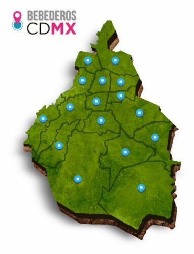
Earlier this summer, Mexico City’s Water System (SACMEX) inaugurated a network of 230 drinking fountains installed in public spaces across the city. The fountains are part of the city’s initiative to curb reliance on bottled water. (Mexicans consume more bottled water per person than any other country in the world).

water-fountains-mexico-city

Click for interactive map of Mexico City water fountains

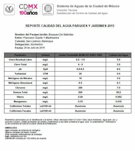
The sites for the fountains were selected taking local water quality into account. An interactive website enables residents and visitors alike to find the locations of the fountains, and offers up-to-date information about the water quality parameters.

water-quality-xochimilco-july-2015.

Sample water quality report – Xochimilco, July 2015 [Click to enlarge]

Water from all the fountains is being tested on a regular basis to ensure that it complies fully with official water quality standards.

Related posts:

Mexico’s tallest waterfalls

 Other, Updates to Geo-Mexico  Comments Off on Mexico’s tallest waterfalls
Aug 032015
 

As we saw in “How long is Mexico’s coastline?“, geographical “facts” and “records” are often not quite as simple to determine as might appear at first sight.

Take waterfalls for example. Mexico’s “highest” waterfalls are not necessarily the same as Mexico’s “tallest” waterfalls, since height refers to elevation, rather than stature. I’m not sure which is Mexico’s highest waterfall, but assume it is likely to be a small waterfall near the summit of one of Mexico’s many major volcanic peaks.

Mexico’s tallest waterfall, on the other hand, is well-known, or is it? Older sources still list the Cascada de Basaseachic in the Copper Canyon region of northern Mexico as the country’s tallest waterfall. That waterfall is 246 meters (807 feet) tall, according to geographer Robert Schmidt, a calculation subsequent confirmed by measurements made by members of a Mexican climbing expedition.

This short Postandfly video shows the Basaseachic Waterfall from the air:

The Basaseachic Waterfall is normally considered to operate year-round, though very little water flows over it on some occasions during the dry season.

In terms of total drop, however, and if we include waterfalls that are seasonal, the Basaseachic Waterfall is overshadowed by the nearby Cascada de Piedra Bolada (Volada). The Piedra Bolada Waterfall, has a total drop of 453 meters (1486 feet), but flows only during the summer rainy season. It is much less accessible, and its true dimensions were only worked out for the first time by an expedition as recently as 1995 by members of the Speology Group of Ciudad Cuauhtémoc, led by Carlos Lazcano.

This latter sections of this amateur video of the Piedra Bolada Waterfall show some of the amazing scenery in this remote area of Mexico:

Curiously, there is some debate as to whether this waterfall should be called Cascada de Piedra Volada (which would translate as the “Flying Stone Waterfall”) or Cascada de Piedra Bolada (“Round Stone Waterfall”). According to members of the Speology Group of Ciudad Cuauhtémoc, its true name is definitely Piedra Bolada, a name referring to a spherical stone, and used in addition for the local stream and for the nearest human settlement.

So, which is Mexico’s tallest waterfall? Well, it all depends…

Related posts:

Access to safe water is a human right in Mexico

 Mexico's geography in the Press  Comments Off on Access to safe water is a human right in Mexico
Dec 132014
 

Earlier this year, David Korenfeld, the director of Mexico’s National Water Commission (Conagua), was chosen to head the inter-governmental council that oversees UNESCO’s International Hydrological Program (IHP). The IHP is the only inter-governmental program of the U.N. system devoted to water research, water-resources management, and education and capacity building.

In his acceptance speech, Korenfeld called for “greater synergy between decision makers and specialists to combine theory and practice” and stated that “significant challenges remain [in the water sector], including integral basin management, application of the human right to water and water security and sustainability in the context of climate change.

Recent events demonstrate that Mexican courts are happy to uphold the view that water is a basic human right. The 5 Dec 2014 issue of the OOSKAnews, a newsletter dedicated to water industry professionals, included the following short piece about a landmark recent decision by Mexico’s Supreme Court that represents the first ever Supreme Court decision in Mexico upholding the nation’s stance that “water is a basic human right.”

The Supreme Court has for the first time awarded an “amparo” (similar to an injunction, a remedy for the protection of constitutional rights), based on the human right to water.

In this case, members of the court unanimously sided with Lidia Velázquez Reynoso, a resident of the Ampliación Tres de Mayo area in the municipality of Xochitepec, in the state of Morelos.

In their ruling, the court said authorities must meet their obligation to provide Velázquez’s residence with “access, availability, and sanitation of water for personal and domestic consumption in a sufficient, safe, acceptable, and affordable form.” A lower court had already ruled in favor of Velázquez, but the case was appealed.

The Supreme Court said responsible authorities had failed to guaranteed regular delivery of water, since merely connecting Velázquez’s residence to the water system was not good enough. Water quality and volume must also be taken into account. The court said that the water must meet World Health Organization standards, and the volume provided must be at least 50 to 100 liters per person per day.

The court ordered authorities to not only deliver the water to Velázquez, but also to remit records showing that the water meets national and international standards.

(OOSKAnews, 5 December 2014)

Related posts:

How does Mexico’s water footprint compare to that of other countries?

 Books and resources  Comments Off on How does Mexico’s water footprint compare to that of other countries?
Oct 292014
 

In a previous post, we saw how Mexico is a major net importer of “virtual” water. In this post we take a closer look at Mexico’s water footprint. The data throughout this post come from The Water footprint of Mexico in the context of North America (pdf file).

Individual products each have their own water footprint in terms of the total amount of water involved in their production, processing and marketing. For example a single cup of coffee represents (on average) a water footprint of 140 liters. Other water footprints include:

  • A single letter-sized sheet of paper – 10 liters
  • Microchip – 32 liters
  • Pair of leather shoes – 8000 liters
  • Glass of milk 200 liters
  • Glass of wine 120 liters
  • Tomato 13 liters
  • Hamburger (150 gram) 2400 liters

From numbers like these, it is possible to calculate the water footprint for an individual consumer in a particular country, and also for an average consumer in each country.

How does the water footprint in Mexico compare to other countries?

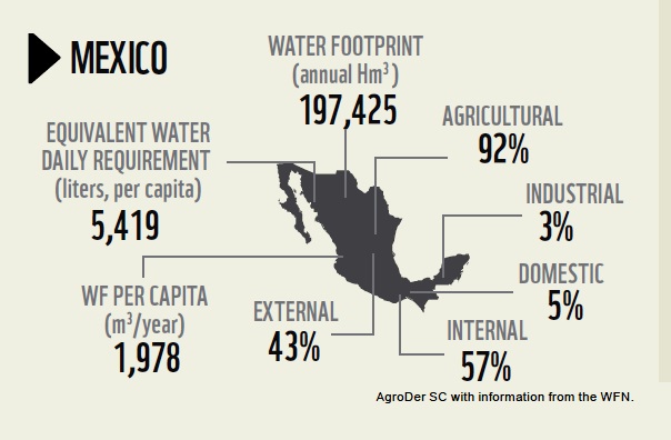
The water footprint of Mexico (WWF 2012)

The water footprint of Mexico (WWF 2012)

The graphic shows that Mexico’s total water footprint (all consumers) is 197,425 Hm³, of which 92% is agricultural, 3% industrial and 5% domestic. Only 57% of Mexico’s water footprint is internal, the remaining 43% is external (ie water used in other countries to make or produce items imported into Mexico). The average water footprint per person in Mexico comes to 5419 liters/day (or 1978 m³/year).

The global average water footprint (all countries, all consumers) in 2010 was 1,385 m³/y. However, some countries have much higher average water footprint/persons than others. For example, the average consumer in the USA has a water footprint of 2,842 m³/y, whereas in China and India the average water footprints are 1,071 and 1,089 m³/y respectively.

The water footprint of an average consumer worldwide  is primarily determined by their consumption of cereal products (contributes 27% to the average water footprint), followed by meat (22%) and milk products (7%).

It should be remembered that countries which heavily rely on foreign water resources may have significant impacts on water consumption and pollution elsewhere.

Full report:

Related posts:

Mexico is a major net importer of “virtual” water

 Books and resources, Teaching ideas  Comments Off on Mexico is a major net importer of “virtual” water
Oct 132014
 

The concept of “virtual water” was developed by Professor J.A. Allan of King’s College (London University) and the School of Oriental and African Studies. Allan used it to support his argument that Middle Eastern countries could save their scarce water resources by relying more on food imports. The idea was sufficiently novel for Allan to be awarded the 2008 Stockholm Water Prize.

In Allan’s words, “The water is said to be virtual because once the wheat is grown, the real water used to grow it is no longer actually contained in the wheat. The concept of virtual water helps us realize how much water is needed to produce different goods and services. In semi-arid and arid areas, knowing the virtual water value of a good or service can be useful towards determining how best to use the scarce water available.”

As one example, producing a single kilogram of wheat requires (on average) around 1.5 cubic meters of water, with the precise volume depending on climatic conditions and farming techniques. The amount of water required to grow or make a product is known as the “water footprint” of the product.

Hoekstra and Chapagain have defined the virtual-water content of a product, commodity, good or service, as “the volume of freshwater used to produce the product, measured at the place where the product was actually produced”. The virtual water content is the sum of the water used in the various steps of the production chain.

Additional examples, showing the water footprint of producing one kilogram of:

  • biodiesel from soya –  11.4 cubic meters
  • beef –  15.4 cubic meters
  • butter –  5.5 cubic meters
  • chocolate – 17.0 cubic meters
  • pasta –  1.85 cubic meters
  • sugar (from cane) –  0.2 cubic meters

While the idea of virtual water has attracted some attention, its methodology is contested, and its quantification is not yet sufficiently precise to offer much potential for policy decisions.

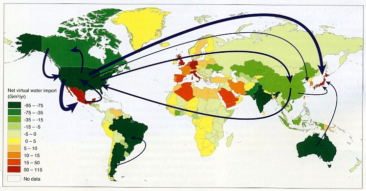
Imports and exports of virtual water represent the “hidden” flows of water involved when food and other commodities are traded from one place to another. The map below (from Hoekstra and Mekonnen, 2012) shows the net imports (imports minus exports) of virtual water for different countries for the decade 1996-2005. Note that only the major flows are shown.

water-virtual-tradeIn North America, both the USA and Canada have a significant positive virtual water balance (i.e. they are major exporters of virtual water), whereas Mexico has a significant negative water balance, and is clearly one of the world’s largest importers of virtual water.

As Allan’s original work suggests, this is not necessarily bad news since it may imply that Mexico is currently using less of its own (limited) water resources than it might otherwise have to. In other words, Mexico’s virtual water imports may be delaying the inevitable crunch time when water usage becomes a critical limiting factor in the nation’s development.

Source of map

A.Y. Hoekstra and M.M. Mekonnen. 2012. The water footprint of humanity. Proc. Nat. Academy of Sciences, 109, 3232-7. Map was reproduced in “Spotlight on virtual water” by Stuart N. Lane in Geography, vol 99-1, Spring 2014, 51-3.

Related posts:

Test wells being drilled to assess Mexico City’s deep water aquifer

 Mexico's geography in the Press, Updates to Geo-Mexico  Comments Off on Test wells being drilled to assess Mexico City’s deep water aquifer
Sep 132014
 

Pemex, Mexico’s state-owned oil giant, will start drilling the first of two deep exploratory wells in Mexico City later this month to investigate an aquifer deep below the city that is believed to hold vast quantities of potable quality water. For further background, please see our previous post on this topic:

The test wells are part of a $30 million multi-agency study now underway that incorporates experts from the Water System of Mexico City (SACM), the National Water Commission (CONAGUA), the engineering and geology departments of the National Autonomous University of Mexico (UNAM), and Pemex, which is providing the technology to drill the wells.

Later this month, Pemex will start drilling the first 2000-meter-deep test well in the Magdalena Mixhuca Sports City area, in the eastern part of Mexico City. Each well will cost an estimated $7.6 million to complete.

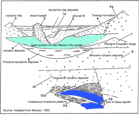
Schematic stratigraphy of the southern portion of the Basin of Mexico.

Schematic stratigraphy of the southern portion of the Basin of Mexico.
Source: Adapted from Mooser, 1990.

Ramón Aguirre, the CEO of SACM, says that the two test wells will target two different zones, increasing the chances of demonstrating the value of the aquifer as a viable source of water for Mexico City. In particular, Aguirre expects the wells to help confirm that there is an impermeable cap of clay separating the deep aquifer from the principal aquifer in the area (from which water is already extracted). An impermeable layer would mean that water could be safely removed from the deep aquifer without leading to downward drainage of water from the aquifer above. It is expected to take about two years for the initial studies to be completed.

In its National Water Plan, CONAGUA has warned that population growth in the Valley of Mexico could result in serious water shortages by 2030, reducing annual availability from about 4,230 cubic meters/person to less than 1,000 cubic meters/person.

The major aquifer currently used lies at a depth of between 60 and 400 meters and is heavily over-utilized. There are about 630 wells in the Federal District alone; all are overexploited and have an average life expectancy of 30 years. Current extraction from the aquifer is around 17,000 liters/second, while its natural recharge capacity is only 8000-9000 liters/second. It is believed that the deep aquifer could be capable of supplying approximately 5000 liters/second.

Related posts:

Recent progress in waste water treatment in Mexico

 Mexico's geography in the Press  Comments Off on Recent progress in waste water treatment in Mexico
Aug 252014
 

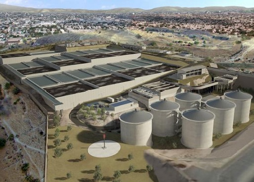
Two wastewater treatment plants have been in the news recently. The first is the $230 million Agua Prieta wastewater treatment plant, located north of Guadalajara in Jalisco, which was formally inaugurated last month. It is the first stage in a plan to restore the heavily polluted Santiago River back to health. The Santiago is the outflow from Lake Chapala and receives pollutants from the industrial zone of El Salto outside Guadalajara. The initial capacity of the Agua Prieta plant is 6,500 liters/second, almost all of which is returned to the river after treatment.

The plant was built by a consortium led by ICA subsidiary Conoisa, Atlatec, and Servicios de Agua Trident under a 20-year concession. President Enrique Peña Nieto claims on his government webpage that, “Integrated, sustainable water management is a government priority. The challenge is even greater because almost 50% of the wastewater returned to the environment does not undergo any form of treatment… The Agua Prieta Wastewater Treatment Plant in Zapopan… [will] improve the quality of life of 3.3 million inhabitants in the metropolitan area of Guadalajara… It will treat 82% of the wastewater in the area, and 100% when the complementary sewage works are completed.”

agua-prieta-wastewater-According to government figures, waste water treatment coverage at the national level is currently 50.3%, with a 2018 target of 63%. Agua Prieta has raised national coverage to 53.3%, and will boost it to 54.3% once the plant is operating at full capacity and treating 8,500 liters/second of wastewater. At the state level, Jalisco is now treating 32% of its wastewater.

The Agua Prieta plant is currently the largest of its kind in Mexico and is powered by biogas derived from the wastewater sludge. However, an even larger plant is under construction, in the state of Hidalgo in central Mexico. The Atotonilco Wastewater Treatment Plant is being built by a consortium, including Mexican construction companies ICA and IDEAL, Mitsui subsidiary Atlatec and Spanish firm Acciona Agua, that won the concession to design, build, and operate this plant for 22 years, at which point the plant will be transferred to federal ownership. Work began in 2010 and is due to be completed by 2015.

The Atotonilco Wastewater Treatment Plant will be the largest wastewater plant in Latin America and one of the largest in the world, with a biological treatment capacity of 23,000 liters/second (1.99 million m3/day). The wastewater treatment is performed by a series of conventional processes, with an additional chemical process during the rainy season. Treated waters from this plant are already being used in agriculture without any additional cleaning steps. The plant is self-sufficient in terms of energy usage, since it converts the methane offgas from the wastewater sludge into electrical energy.

Related posts:

Mexicans drink more bottled water per person than anywhere else in the world

 Updates to Geo-Mexico  Comments Off on Mexicans drink more bottled water per person than anywhere else in the world
May 032014
 

Mexicans are the world’s largest consumers of bottled water, both in individual small bottles (1.5 liters or less) and in garrafones (large, 20-liter bottles).

The main reason is a lack of confidence in the purity of public water supplies, resulting in part from perceived inefficiencies in how city water systems are managed and maintained. These concerns may be valid in some parts of Mexico, but are certainly not the case in all areas. Other factors resulting in a high acceptance of bottled water are the convenience, Mexico’s warm climate, and the vigorous publicity and advertising campaigns carried out by bottled water companies. It does not help that consumer groups repeatedly express concerns even about the quality of water in garrafones, claiming that some companies apparently take insufficient precautions to prevent its contamination.

For its part, the National Water Commission repeatedly claims that the problem of water quality is not due to the main distribution lines in Mexico, but to problems at a local level, in the final stages of the network between supply and consumers.

garrafon

Typical 20-liter garrafon

According to Euromonitor International, bottled water consumption in Mexico in 2013 averaged 186.7 liters/person, well ahead of Italy (175.1 liters/person), Nigeria (163.1), Turkey (147.7) and Spain (143.2). [Note that an earlier estimate in 2010 by Beverage Marketing Corporation put per person consumption of bottled water in Mexico at 234 liters a year, with equivalent figures for Italy, Spain and the USA of 191 liters, 119 liters and 110 liters respectively; the difference from 2010 to 2013 is almost certainly due to methodological differences].

Mexico consumes about 13% of all bottled water sold in the world! The only countries consuming more bottled water (in total volume) than Mexico were the much more populous countries of the USA, China and Nigeria.

Bottling water is a highly profitable business. The cost of 1,000 liters from the tap is 25 pesos (about 2 dollars); the same water, sold in bottles, is worth between 6000 and 8500 pesos (450 to 650 dollars).

The bottled water market in Mexico has grown from 6.5 billion dollars in 2009 to 10.4 billion in 2013, according to Euromonitor.  It is dominated by three foreign firms: Danone (France), Coca-Cola (USA) and PepsiCo (USA). Between them, they supply 82% of the market, according to a Euromonitor report, with the three leading brands being Bonafont (Danone) which accounts for 38% of the market, followed by Ciel (Coca-Cola) which has a 25% share and Epura (PepsiCo) 19%.

The cost of bottled water in an average Mexican household is considerable. For instance, assuming an average consumption of 15.55 liters/month/person, and that all water is bought in 1-liter bottles (which cost about 8 pesos each), then the monthly cost per household would be close to 500 pesos (38 dollars).

An industry dominated by four multinationals

Inside the Bottle: An Exposé of the Bottled Water Industry, a book by Canadian activist Tony Clark, provides a vivid and disturbing portrayal of how, worldwide, four big companies – Nestlé, PepsiCo, Coca-Cola and Danone – dominate the bottled water industry. As summarized by infinitewaterinc.com, the book examines several key issues of public concern about the operations of these companies, including how they:

  • pay little or nothing for the water they take from rural springs or public systems;
  • turn ‘water’ into ‘water’ through elaborate treatment processes;
  • produce a product that is not necessarily safer then, nor as regulated as, tap water;
  • package it in plastic bottles made of environmentally destructive toxic chemicals;
  • market it to an unsuspecting public as ‘pure, healthy, safe drinking water’; and
  • sell it at prices hundreds, even thousands of times more costly than ordinary tap water.

Related posts:

Water management progress in the Lerma-Chapala basin

 Books and resources  Comments Off on Water management progress in the Lerma-Chapala basin
Jan 112014
 

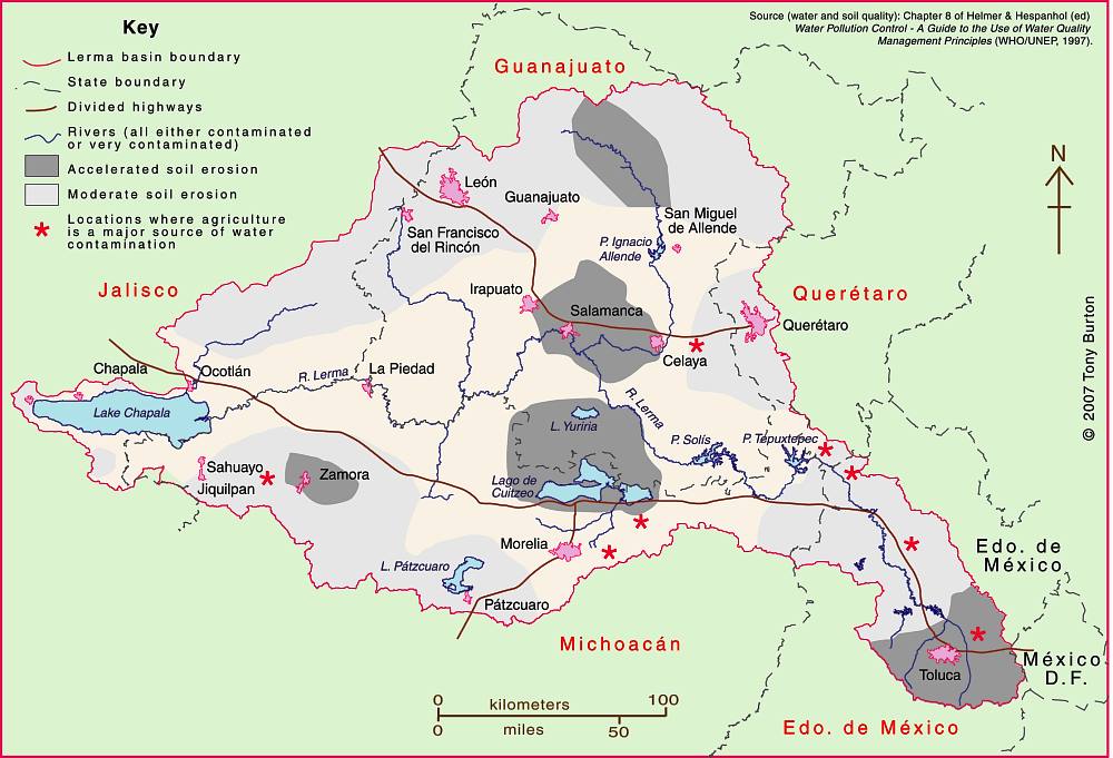
The Lerma-Chapala Basin (see map) is one of Mexico’s major river systems, comprising portions of 127 municipalities in five states: México, Querétaro, Michoacán, Guanajuato and Jalisco.

The basin has considerable economic importance. It occupies only 2.9% of Mexico’s total landmass, but is home to 9.3% of Mexico’s total population, and its economic activities account for 11.5% of national GDP. The basin’s GDP (about 80 billion dollars/year) is higher than the GDP of many countries, including Guatemala, Costa Rica, Honduras, Paraguay, Bolivia, Uruguay, Croatia, Jordan, North Korea and Slovenia.

Lerma-Chapala Basin

The Lerma-Chapala Basin. Click map to enlarge. Credit: Tony Burton / Geo-Mexico

Given this level of economic activity, it is probably not surprising that the pressures on natural resources in the basin, especially water, are enormous. Historically, the downstream consequence of the Lerma Basin’s agricultural and industrial success has been an inadequate supply of (heavily polluted) water to Lake Chapala.

Following decades of political inactivity or ineffectiveness in managing the basin’s water resources, solid progress finally appears to have been made. Part of the problem previously was a distinct lack of hard information about this region at the river basin scale. The statistics for such key elements as water usage, number of wells, replenishment rates, etc. were all (to put it politely) contested.

Fortunately, several scientific publications in recent years have redressed the balance, and the Lerma-Chapala Basin is now probably the best documented river basin in Mexico. This has allowed state and federal governments to negotiate a series of management agreements that are showing some positive signs of success.

The first of these key publications was “The Lerma-Chapala Watershed: Evaluation and Management“, edited by Anne M. Hansen and Manfred van Afferden (Klewer Academic/Plenum Publishers, 2001). This collection of articles featured contributions from researchers in several universities and research centers, including the University of Guadalajara, Mexican Institute of Water Technology, Autonomous University of Guadalajara, Baylor University, the Harvard School of Public Health and Environment Canada. Click here for my comprehensive description and review of this volume on MexConnect.com.

Perhaps the single most important publication was the Atlas de la cuenca Lerma-Chapala, construyendo una visión conjunta in 2006. Cotler Ávalos, Helena; Marisa Mazari Hiriart y José de Anda Sánchez (eds.), SEMARNATINE-UNAM-IE, México, 2006, 196 pages. (The link is to a low-resolution pdf of the entire atlas). The atlas’s 196 pages showcase specially-commissioned maps of climate, soils, vegetation, land use, urban growth, water quality,  and a myriad of other topics.

More recently, a Case Study of the Lerma-Chapala river basin: : A fruitful sustainable water management experience was prepared in 2012 for the 4th UN World Water Development Report “Managing water under uncertainty and risk”. This detailed case study should prove to be especially useful in high school and university classes.

The Case Study provides a solid background to the Lerma-Chapala basin, including development indicators, followed by a history of attempts to provide a structural framework for its management.

In the words of its authors, “The Lerma Chapala Case Study is a story of how the rapid economic and demographic growth of post-Second World War Mexico, a period known as the “Mexican Miracle”, turned into a shambles when water resources and sustainable balances were lost, leading to pressure on water resources and their management, including water allocation conflicts and social turbulence.”

On a positive note, the study describes how meticulous study of the main interactions between water and other key development elements such as economic activity and social structures, enabled a thorough assessment on how to drive change in a manner largely accepted by the key stakeholders.

The early results are “stimulating”. “Drawbacks and obstacles are formidable. The main yields are water treatment and allocation, finances, public awareness, participation and involvement. The main obstacles are centralization, turbid interests, weak capacity building, fragile water knowledge; continuity; financial constraints; and weak planning.”

Sustainable water usage is still a long way off. As the Case Study cautions, “There is still much to do, considering the system Lerma-Chapala responds directly to a hydrologic system where joint action and especially abundant involvement of informed users is required, to achieve sustainable use of water resource.”

One minor caveat is that the Case Study does not offer full bibliographic reference for all of the maps it uses, which include several from the previously-described Atlas de la cuenca Lerma-Chapala, construyendo una visión conjunta.

Related posts:

The city of León in Guanajuato uses Google Earth to monitor its water usage

 Mexico's geography in the Press  Comments Off on The city of León in Guanajuato uses Google Earth to monitor its water usage
Dec 212013
 

León, in the state of Guanajuato, is a prosperous industrial city (population 1.6 million), which built its wealth by processing animal hides obtained from the surrounding ranching areas into all manner of leather goods, especially clothing, accessories and shoes, the range of which goes from casual to ultra-fashionable. León does not just have shoe stores, it has shoe shopping centers!

Founded in 1576 and named for a province in Spain, the city became an important colonial center, well positioned on the main trading routes. It later became important for anti-colonial sentiment. Brothers Juan and Ignacio Aldama, born here in the eighteenth century, became key figures in the Independence movement led by Father Miguel Hidalgo. Shortly after Independence, the city’s shoe industry started, introduced by skilled craftsmen from Puebla.

Like any wealthy Mexican city, León has lots of old buildings, including the eighteenth century Cathedral with its fine choir stalls and the Nuestra Señora de los Angeles church, embellished by the interesting carvings of a native craftsman. The impressive Town Hall, with its elaborate façade, is a nineteenth century addition, as is the Manuel Doblado Theatre, designed by José Noriega who also had a hand in building theatres in several other cities in the region, including Guanajuato, Aguascalientes and San Luis Potosí.

leon-agua-monitoreoThe city would have even more old buildings today were it not for the disastrous flood of June 1888 when torrential downpours caused the Río Gómez to burst its banks. A wall of water and debris swept away more than 2000 homes, causing 200 fatalities and making 20,000 homeless. Major engineering works shortly afterwards have ensured that the city is now safe from future events of this kind.

The city has grown into one of Mexico’s most important industrial centers. The position of León has been key to its success. The city is located in central Mexico, close to the major urban areas of Mexico City, Querétaro and Guadalajara. On a broader scale, it is close to the major export markets of the USA, Canada and Central America. Market proximity is enhanced by an excellent communications network, including good road and rail links, easy access to several major airports, and to seaports such as Manzanillo.

Like most cities in central Mexico, one of León’s most pressing problems is how to ensure that its residents and industries have an adequate supply of potable water, even though the city was rated #1 in the country in terms of overall performance in this regard in the 2011 report “Water Management in Mexican Cities”.

In order to monitor the city’s water usage more effectively, engineers from the León Potable Water and Sewerage System (SAPAL) have introduced a sophisticated software system that provides real time data about the city’s water network and wells. It enables the engineers to overlay data like address, owner, account status, and water consumption onto a series of screen connected to Google Earth.

The system was developed in-house by local engineers, starting more than a decade ago, at a fraction of the cost of purchasing a similar system from an external provider. The León system is already being closely studied by water experts from other cities and countries.

SAPAL’s Control and Monitoring Center has a video wall, measuring 7.5 by 2 meters, with 24 LED screens. The center functions 24 hours a day, monitoring details of water distribution for more than 9000 data points, including wells, pipelines and holding tanks.

According to Agustín Báez, the city official responsible for SAPAL operations, the objective is “to have measurement from point of extraction to final use” since “what is not measured is not controlled.”

Sources:

Related posts:

Mexico City explores deep water aquifer

 Mexico's geography in the Press, Updates to Geo-Mexico  Comments Off on Mexico City explores deep water aquifer
Dec 092013
 

Background: The Valley of Mexico is an interior basin about 9000 square km in area. The basin floor sits at an elevation of 2200 meters above sea level and is surrounded by mountains that rise up to more than 5000 meters above sea level. It receives around 700 mm of rainfall a year, with a rainy season from late May to September.

The basin was originally the site of several lakes and marshes, and much of it is underlain by lacustrine sediments up to 100 m thick, beneath which are alluvial sediments up to 500 m thick (see geological cross-section below). These sediments are interstratified with layers of volcanic basalt. Beneath the alluvial sediments are 100 m to 600 m of volcanic deposits, which form the principal Mexico City aquifer (found about 500 m to 1000 m below Mexico City).

As Mexico City has grown, and water demands have increased, this main aquifer has been greatly overexploited, leading to a drop in the level of the water table underground, accompanied by ground subsidence that has had serious consequences for Mexico City:

Feasibility study of a deep aquifer

The National Water Commission (CNA) and Mexico City Water System (SACM) are undertaking a 3-year, 23-million-dollar feasibility study to assess the potential of an aquifer that lies more than 2000 meters below Mexico City. (Our earlier, initial report about this aquifer is here).  The project includes experts from Pemex, CFE and UNAM’s Institute of Geophysics.

Schematic stratigraphy of the southern portion of the Basin of Mexico.

Schematic stratigraphy of the southern portion of the Basin of Mexico.
Source: Adapted from Mooser, 1990.

Initial exploratory wells have shown that the deep aquifer’s water quality is superior to that currently derived from the overexploited shallower wells that extend to depths of around 800m.

It is hoped that the feasibility study will confirm that water from the deep aquifer could be an additional viable source of freshwater for the city. Assuming the deep aquifer is hydrologically independent of the shallower aquifers, this  would not only reduce the need to pump water from the shallower aquifers, but would also avoid the ground subsidence resulting from continued shallow-water extraction. The feasibility study will assess whether or not the deep water aquifer is “fossil” water or is still being recharged from precipitation and underground throughflow. If it is being recharged, the experts will calculate its recharge rate to determine the aquifer’s maximum sustainable yield. (The maximum sustainable yield is the “additional groundwater output from the system which will cause minimal and acceptable levels of stress to the ecosystem with maximum benefits to the society and to the economy”).

The first test well is likely to be sunk in the Magdalena Mixhuca Sports City area, in the eastern part of Mexico City.

This potential deep aquifer source of freshwater could play a vital part in ensuring that future generations of Mexico City residents have a dependable and sustainable water supply.

Mexico’s consideration of utilizing deep water aquifers runs counter to the prevailing wisdom in the US where it has long been argued that deep water aquifers will be too costly to utilize for fresh water, will never be used, and are therefore more useful as a repository for waste and can be intentionally polluted.

As a result, as this Huffington Post article explains, “policy-makers often exempt these deep aquifers from clean water protections and allow energy and mining companies to inject pollutants directly into them.”  The article adds that, “the U.S. Environmental Protection Agency has issued more than 1,500 permits for companies to pollute such aquifers in some of the driest regions. Frequently, the reason was that the water lies too deep to be worth protecting.”

References:

Mooser, F. 1990. “Estratigrafía y estructura del Valle de México en el subseulo de la cuenca del Valle de México y su relacíon con la Ingeniería de cimentaciones, a cinco anos del sismo”, in Revista de la Sociedad Mexicana de Mecánica de Suelos. Mexico, D.F.

For a detailed description of Mexico City’s shallower aquifer and its exploitation, see Mexico City’s Water Supply: Improving the Outlook for Sustainability (1995) (viewable online or register for a free download)

Related posts:

May 272013
 

Kudos to the Earth Island Institute for responding to the many criticisms we and others made of a blog article (“Water Pollution Plagues Mexico’s Scenic Pacific Coast”) by pulling it from their website. The following post has been edited to reflect that fact.

Water quality is a serious concern in many parts of Mexico and Geo-Mexico regularly includes short articles about the main issues as well as case studies related to water pollution (see “Related posts” below).

Ron Granich, a regular Geo-Mexico reader who lives in Pátzcuaro (Michoacán) and recognizes our keen interest in Mexico’s water quality kindly drew our attention to a recent article published on the website of the Earth Island Journal. Sadly, the blog article left much to be desired. The article was subtitled, “Tourists largely unaware that industrial pollution from rivers upstream is making them sick”, and attempted to argue that the pollution of Mexico’s Santiago River is a direct cause of the poor water quality of beach towns such as Sayulita.

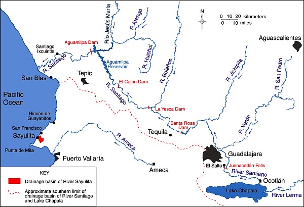
The slight problem with this thesis is that the Santiago River flows nowhere near Sayulita and has no connection to the miniscule Sayulita River, far to its south (see map). There is no question that the Santiago is polluted. It collects serious pollutants from the major industrial area of El Salto (a short distance southeast of Guadalajara) and from Guadalajara, and from many smaller settlements along the way. More contaminants are added near its mouth, where the swampy delta has been transformed into productive fields, including tobacco plantations.

Main rivers of Western Mexico.

Map of the main rivers of Western Mexico. Credit: Tony Burton / Geo-Mexico; all rights reserved.

Pollution of the River Santiago is particularly evident at the Juanacatlán Falls near El Salto:

After the Juanacatlán Falls, the Santiago flows in a deep, steep-sided canyon for most of its course (which explains why no fewer than three major dams for hydro-electric power have been built along this stretch, including the one at La Yesca) before meandering across its delta to flow into the Pacific Ocean a short distance north of San Blas.

The Santiago River has no conceivable influence on the pollution levels in the rivers near Sayulita and San Francisco or indeed on beaches in their vicinity. This is not to say that those beaches are clean. The beaches of the Nayarit Riviera may indeed have high levels of Enterococcus spp, as we reported recently when looking at the murky world of water statistics in Mexico.

Note on clean water standards in Mexico and the USA:

It is sometimes argued that Mexico and the USA have different standards for what represents “clean water”. For marine (beach) environments, the U.S. limit is 35 Enterococci per 100 ml. of water, and is based on calculating a geometric mean of counts performed over a five week period. This method greatly reduces the impact of peak Enterococci counts. However, the Mexican limit of 100 Enterococci/100 ml. is based on a single sample maximum value. As explained in this US EPA technical document, Water Quality Standards for Coastal Recreation Waters: Using Single Sample Maximum Values in State Water Quality Standards, the two limits are approximately equivalent in terms of water quality. In other words, a geometric mean of 35 Enterococci/100 ml. means that the water is about as clean as a single maximum value of 100 Enterococci/100 ml.

Water quality IS a major concern in much of Mexico, and we applaud the Earth Island Institute for seeking to draw attention to the issues involved, and for their recent action in removing the original article, which helps to ensure that discussions of these issues are based on facts and not on misconceptions.

As always, we welcome discussion about this (and all our posts) via the comments feature. If the comments feature is not visible, simply click the title of the relevant post, and scroll down.

Related posts:

How can Mexico City find sufficient water?

 Updates to Geo-Mexico  Comments Off on How can Mexico City find sufficient water?
May 202013
 

What happens if or when Mexico City needs more water than it is using at present? There are several options, depending on whether authorities choose to modify demand, supply, or both in order to improve the future situation.

In terms of managing (reducing) demand, conservation measures are one possibility. Changing consumer habits may require not only educational programs, but also usage tariffs that reflect the true costs of supply, and that encourage consumers to install water-saving devices and introduce water-saving practices in their daily lives. Demand would also be reduced if less water was lost through leakage. As mentioned in a previous post, in 2009, the National Water Commission (Conagua) estimated that a staggering 40% of potable water nationwide was being lost through leaks in city and municipal systems, with a further 20% not properly accounted for due to billing errors and clandestine connections.

Managing demand may be easier to achieve than managing supply, given that recent efforts to increase supply have met with concerted opposition from environmentalists and the people living in the areas from which water would be transferred to the city. In the last half of the twentieth century, while one political party (PRI) held power, it was possible for politicians to largely ignore the conflicts resulting from inter-basin transfers, arguing that their “solutions” served a national need. Now that local, state and federal politics are more contested, that approach is potential political suicide.

From a political perspective, the most acceptable source of additional water for Mexico City would probably be the recently identified deep aquifer described in Mexico’s major cities confront serious water supply issues. However, that discovery requires further research before its maximum sustainable yield can be determined or it can be brought into service.

Less politically acceptable are the various proposals to bring water from elsewhere to satisfy the thirst of Mexico City. One of the most frequently voiced suggestions is to add a fourth phase to the Cutzamala scheme (see Where does Mexico City get its water from?) to increase the amount of water it supplies by more than 25% to 24 m³/s. In addition, the plan would provide treatment for 42 m3/s of wastewater. This fourth phase, known as the Temascaltepec project (see map), would require the construction of a 120-meter-high, 740-meter-long dam on the Temascaltepec River to create a reservoir with a capacity of 65 million m³.

Map of the Cutzamala project

Map of the Cutzamala project. Click to enlarge.

Aqueducts and a 19-km-long tunnel would carry the water to the Valle de Bravo reservoir. The estimated cost would be $500 million. The Temascaltepec project is opposed by environmentalists and locals and is not likely to get under way any time soon. The residents of the villages near the proposed dam site are afraid that the project would cause their local springs to dry up and would adversely impact their farming of maize, sugar cane, banana, tomato, melon and peas.

To the south of Mexico City, an entirely different proposal is to bring water from the Amacuzac, Tecolutla and Atoyac Rivers, by damming the Amacuzac River, creating a 67 km2 reservoir (between the states of Morelos, Guerrero and Puebla) capable of storing 4,000 million cubic meters. Supplying Mexico City would require a 160 km long aqueduct, and would involve pumping water to a height of 1825 meters, requiring up to 5% of Mexico’s annual national electricity production. On the plus side, this could reduce the future abstraction of groundwater by as much as 50 m³/s.

Related posts:

Where does Mexico City get its water?

 Other, Updates to Geo-Mexico  Comments Off on Where does Mexico City get its water?
May 092013
 

Mexico City is one of the world’s largest cities, and the metropolitan area of Greater Mexico City (map) extends well beyond the borders of the Federal District (Mexico City proper) into neighboring states, especially the State of Mexico.  The total population of Greater Mexico City is about 22 million, all of whom need safe access to water.

An old joke relates how engineers initially rejoiced at successfully draining the former lake on which Mexico City was built (something the Aztecs had tried, but failed to achieve), only to discover that the city now lacked any reliable source of fresh water for its inhabitants (something the Aztecs had successfully managed by building a system of aqueducts). Water has been a major issue for Mexico City ever since it was founded almost 700 years ago.

The Mexico City Metropolitan Area’s water supply is currently calculated to be around 82 m³/s. (The precise figure is unclear because many wells are reportedly unregistered). The main sources of water (and their approximate contributions to total water supply) are:

  • Abstraction of groundwater (73%)
  • Cutzamala system (18%)
  • Lerma system (6%)
  • Rivers and springs (3%)

In several previous posts we have looked at several issues arising from groundwater abstraction:

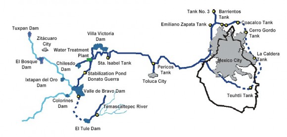
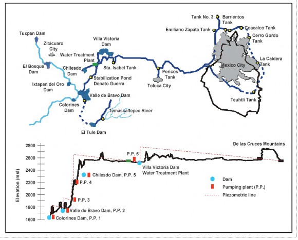
In this post we focus on the Cutzamala system (see graphic), one of Mexico’s most ambitious engineering feats of its time.

Cutzamala scheme

Cutzamala scheme (click to enlarge). Source: IMTA (1987)

The Cutzamala system supplies potable water to 11 boroughs (delegaciones) of the Federal District and 11 municipalities in the State of Mexico. The Cutzamala system is one of the largest water supply systems in the world, in terms of both the total quantity of water supplied (about 485 million cubic meters/yr) and in terms of the 1100 meters (3600 feet) difference in elevation that has to be overcome. The system cost about $1.3 billion, and was undertaken in three successive phases of construction, completed in 1982 (Villa Victoria dam), 1985 (incorporation of the Valle de Bravo and El Bosque dams, originally built in the 1940s and 1950s) and 1993 respectively.

As Cecillia Tortajada points out in Who Has Access to Water? Case Study of Mexico City Metropolitan Area, the investment of $1.3 billion was, at the time (1996), “higher than the national investment in the entire public sector in Mexico… in the areas of education ($700 million), health and social security ($400 million), agriculture, livestock and rural development ($105 million), tourism ($50 million), and marine sector ($60 million).”

The system includes 7 dams and reservoirs for storage, 6 major pumping stations (P.P. on the graphic) and a water purification plant. The volumes stored in the system are dependent on previous years’ rainfall. Water is transferred to the Valley of Mexico from more than 150 km away via reservoirs, pumping stations, open channels, tunnels, pipelines and aqueducts.

The Cutzamala system incorporates the Valle de Bravo and El Bosque dams, built originally as part of the “Miguel Alemán” project that generated hydro-electric power from the headwaters of the Cutzamala River (hence the name for the whole system). The reservoir at Valle de Bravo is an important resource for tourism and watersports. The hydro-electric power scheme is no longer functioning. The Cutzamala system has the capacity to supply up to 19 m³/s of water to the Valley of Mexico. In practice, it supplies almost 20% of the Valley of Mexico’s total water supply (usually quoted as being 82 m³/s).

The pumping required to lift water 1100 meters from the lowest storage point to the system’s highest point (from where gravity flow takes over) consumes a significant amount of energy, variously estimated at between 1.3 and 1.8 terawatt hours a year, equivalent to about 0.6% of Mexico’s total energy consumption, and representing a cost of about 65 million dollars/yr. This amount of electricity is claimed to be roughly equivalent to the annual energy consumption of the metropolitan area of Puebla (population 2.7 million).

The total operational costs for running the Cutzamala System are estimated at $130 million/yr. [all figures in US dollars]. Even operating at full capacity (19 m³/s or 600 million m³/yr), the approximate average cost of water would be $0.214/m³. The true costs are higher given that these calculations do not include the costs of treatment or distribution within the metropolitan area. The price charged to consumers averages about $0.20/m³.

The completion of the Cutzamala system involved resettling some villages. The plans included the construction of some 200 “social” projects to improve living conditions for the people most affected, including local potable water distribution systems, schools and roads. However, more than a decade after completion, there were still some unresolved conflicts concerning people forced to move, with many of them still claiming that they had received insufficient compensation.

Maintaining the Cutzamala system has been an on-going challenge. Most maintenance is scheduled for the Easter holiday period, when factories and offices close down and many Mexico City residents head for the beach, reducing demand for water. Since 1993, a parallel system of canals and pipelines has been built alongside the original system, allowing for sections of the old system to be shut down for maintenance, obviating the need to close the entire system whenever work is carried out.

Main sources:

Related posts:

Apr 262013
 

An amendment to Mexico’s constitution in 2011 made access to potable water a basic human right, but Mexico’s major cities face unprecedented challenges in meeting future demands for drinking water. In this post we look at some of the water supply issues relating to Mexico City and Guadalajara.

In 2009, the National Water Commission (Conagua) estimated that a staggering 40% of potable water nationwide was being lost through leaks in city and municipal systems, with a further 20% not properly accounted for due to billing errors and clandestine connections. Conagua recently announced a new plan for Mexico City, that it hopes will safeguard that city’s water supply for the next 25 years. (OOSKAnews 18 April 2013)

The plan creates a new metropolitan decision-making body, which will be empowered to choose which sources of water will be used, set timelines and commitments, and monitor all activities carried out under the plan. Conagua head David Korenfeld said that establishing a single water management body for the entire metropolitan zone in the Valley of Mexico means that, “there exists no possibility of misinterpretation in collaboration”. At present, several different water management bodies have responsibility for different parts of the Metropolitan Area, which extends well beyond the boundaries of the Federal District (México D.F.) into the neighboring State of México (Estado de México).

Korenfeld argues that potable water prices must be related to the real costs of water production, system maintenance and service delivery, and that subsidies must be cut in order to achieve efficient, sustainable and equitable water management. According to Conagua data, water tariffs in the Valley of Mexico cover only  51% of the true costs of service provision.The new plan calls for the existing Cutzamala water system to be completely restructured, with an alternative channel created to bring water to the city.

sacm officeRamón Aguirre Díaz, the director of the Mexico City Water System (SACM) which would come under the new decision-making body, says that one of the main challenges is to ensure adequate water supply to the municipality of Iztapalapa. Iztapalapa is the most populous and fastest growing of the city districts, with over 90% of its territory urbanized. The SACM is suggesting a six-year, 150-million-dollar plan to resolve the situation, which would include waiving water charges for some areas where service has been poor and sporadic. Aguirre stressed the need for the government and society “to succeed in reducing water consumption and improve their habits”, saying that consumption needs to be cut by at least 30%.

Coincidentally, it is in Iztapalapa where the findings from several deep wells allowed Mexico City engineers and geologists to announce earlier this year that a 40-million-dollar study conducted over 18 months had identified a major new aquifer under Mexico City. The city has an average elevation of 2240 meters above sea level; the new aquifer, which could become a major new source of potable water, is located 2000 meters beneath the surface. The initial announcement claimed that the aquifer could supply as much as 80,000 liters of water a second.

Conagua officials cautioned that the potential usable flow of this aquifer still has to be confirmed and that it may take a further three years of research to establish the maximum sustainable yield.  The aquifer might indeed relieve Mexico City’s physical water scarcity (volumes of supply) at some point in the future, but it would not necessarily overcome the economic water scarcity (cost of supply) faced by many of its residents. (For more about economic water scarcity, see How fast is the ground sinking in Mexico City and what can be done about it?).

Frederick Mooser, arguably Mexico’s most distinguished geologist, was quoted in the press as saying that the indication of very large reserves of water below a depth of 1500 meters might well alleviate the continued need to extract water from aquifers closer to the surface, extraction that has caused so many problems for the city’s infrastructure. The major aquifer used currently lies at a depth of between 60 and 400 meters. There are about 630 wells in the Federal District alone; all are overexploited and have an average life expectancy of 30 years.

Mooser also pointed out that the results from the wells used to locate the new aquifer show that the area has considerable potential for geothermal power generation in the future.

Mexico’s second city, Guadalajara, also faces sever water management issues. According to a recent press report (OOSKAnews, 11 April 2013), Metropolitan Guadalajara loses 18% of its water through leaks in the supply system (a loss of around 41 million dollars in economic terms)

siapaAccording to an official from the city’s water utility, SIAPA, repairing ailing parts of the network (154 locations have been identified as “vulnerable”) could save most of the 4 million dollars a year currently being spent dealing with emergency repairs. However, the precise location of leaks is difficult to pinpoint because of a lack of metering equipment. In addition to the 18% lost through leaks, SIAPA believes another 12% goes unaccounted for as a result of clandestine connections and incorrect billing.

The biggest reason for leaks is the age of the system. Parts of the water supply networks in Mexico’s major cities are now over 70 years old. For example, in Guadalajara, more than 70% of the city’s 3458 km of main water supply lines is over 70 years old. Replacing the 2544 km of pipes older than 70 years would require investing around 300 million dollars, with a further 500 million dollars needed to upgrade the drainage system. SIAPA’s total investment in renewing and expanding systems is currently about 45 million dollars a year. The water firm is already said to be the most indebted decentralized public agency in the country, with debts of 240 million dollars.

Related posts:

Ecological footprints, marine conservation and Cancun’s underwater sculpture park

 Mexico's geography in the Press  Comments Off on Ecological footprints, marine conservation and Cancun’s underwater sculpture park
Feb 112013
 

The Global Ocean Commission, a new, high-level international effort to try to stave off eco-disaster in the world’s oceans, is being launched tomorrow in London, U.K.. Headed by former UK foreign secretary, David Miliband, former South African finance minister Trevor Manuel, and José María Figueres, a former president of Costa Rica, the Commission will promote international efforts to ensure the effective governance of international waters, and agreements governing such activities as deep sea fishing, pirate fishing, sea-floor mining and geo-engineering, all considered to be potential threats to the long-term viability of ocean ecosystems.

Miliband is quoted as saying that “We are living as if there are three or four planets instead of one, and you can’t get away with that.” Actually, the ecological footprint of the USA, as one example, is much closer to ten “global hectares per person” than three or four. (Each global hectare encompasses the average annual productivity of all biologically productive land and ocean areas in the world). The world’s biocapacity—the amount of resources its ecosystems can supply each year—is only equivalent to about 2 global hectares per person, a value that is declining each year as population increases (see Mexico’s ecological footprint compared to that of other countries).

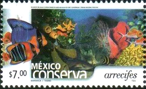
2002 Postage Stamp: reef conservation

2002 Postage Stamp: reef conservation

Mexico is one of the six most biodiverse countries in the world. While it has taken many steps to protect its marine resources, by enacting legistlaiton establishing fishing restrictions and protected areas, much remains to be done. Mexico’s coral reefs are particularly vulnerable. For example, the Cancún Marine Park is one of the most visited stretches of water in the world with over 750,000 visitors each year, placing immense pressure on its resources. We described one unusual conservation effort related to this area in “Artificial reef near Cancún doubles as an underwater art gallery” [Mar 2012] which looked at the work of Artist Jason deCaires Taylor, who created an underwater sculpture park, the Underwater Art Museum (Museo Subaquatico de Arte, MUSA), near Cancún.

The museum, begun in 2009, currently consists of more than 450 permanent life-size sculptures set in the waters surrounding Cancún, Isla Mujeres and Punta Nizuc. Taylor is adding sixty additional underwater sculptures to the park, many of them modeled after local residents. This underwater museum is both attractive and functional, providing new habitat for coral and other marine life, as well as diverting snorkelers and divers away from fragile coral reefs, allowing them more chance to recover from the impacts of overuse.

Two examples of Mexico-USA trans-border water pollution

 Mexico's geography in the Press  Comments Off on Two examples of Mexico-USA trans-border water pollution
Aug 092012
 

In a previous post – Update on the severe drought in northern Mexico – we mentioned two cases where water was being transferred across the Mexico-USA border and where it was proving impossible to meet the terms of existing water treaties in the face of the severe drought in northern Mexico and the southern USA.

In this post, we look at two examples where the major trans-border concern is about water quality not quantity.

Case 1: The New River, California

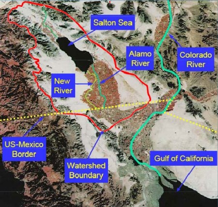
The New River begins in Mexico as the Río Nuevo and receives agricultural runoff and industrial and domestic wastewater from the 1,000,000 or so residents of the metropolitan area of Mexicali, where a water treatment plant now operates. The New River then crosses the border northwards into California (west of the Colorado River) and flows into that state’s largest lake, the Salton Sea. The New River is about 130 kilometers long, with only the first 25 kilometers in Mexico.

The trans-border drainage basin of the New River

The trans-border drainage basin of the New River. Credit: IBWC.

The New River has a long history of high pollution levels, well documented in this Wikipedia entry: New River (Mexico – United States) and is possibly the most polluted river of its size anywhere in the USA. It is also one of the routes used by undocumented migrants entering the USA, as pointed out in this 2-minute video:

The California-Mexico Border Relations Council’s technical advisory committee recently announced a strategic plan to start cleaning up the polluted waters of the New River. In the Californian border city of Calexico, the plan calls for the installation of a 90-million-dollar water disinfection system and trash screens. Downstream, it also includes the creation of water-filtering wetlands in parts of the Imperial Valley, one of the USA’s most important agricultural areas. The strategic plan will also develop an integrated water quality monitoring and reporting program, so that changes in water quality can be quickly traced to source and any necessary cleanup measures can be implemented. The condition of the New River has been improving in the past decade, but much work remains to be done.

Case 2: Wastewater in Nogales, Arizona.

Further east along the border, Arizona state officials are suing the International Boundary and Water Commission (IBWC) for violations to the United States Clean Water Act, alleging that untreated Mexican industrial wastewater, mixed with domestic sewage, continues to cross the USA-Mexico border into the city of Nogales, Arizona. The suit claims that the wastewater has levels of cadmium, cyanide and ammoniacal nitrogen well above legal limits. The Arizona Department of Environmental Quality is demanding that the IBWC install an industrial waste treatment system at the Nogales International Wastewater Treatment Plant.

Related posts:

Greenpeace demands action to clean up Mexico’s surface waters

 Mexico's geography in the Press  Comments Off on Greenpeace demands action to clean up Mexico’s surface waters
Apr 052012
 

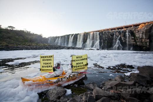
Greenpeace activists chose the Juanacatlán Falls (“The Niagara of Mexico”) for their latest protest to call attention to the poor quality of Mexico’s rivers and lakes. They cited government statistics that show 70% of Mexico’s surface water is contaminated. Most of the pollution comes from industrial dumping, rather than municipal sewage.

It is hard to imagine a better choice. The activists, clad in protective clothing and wearing masks to avoid inhaling toxic gases, paddled kayaks into the River Santiago immediately below the malodorous falls and unfurled banners with slogans such as “Mexican rivers, toxic rivers” (see image).

Greenpeace activists at El Salto de Juanacatlán, 22 March 2012. Photo: Greenpeace.

The activists called on the government to commit to a policy of zero dumping of toxic substances into rivers and lakes by 2020, with sanctions for actions leading to pollution and its effects.

In a coordinated action, thirty NGOs in Jalisco announced the creation of the “Broad Front in Defense of Water and Against Privatization ”, demanding actions towards a fully sustainable use of water. They asked government to take the lead in cleaning up the Santiago River and provide urgent medical attention for residents of communities affected by its high level of pollution (see this blog post). They also called for an end to the privatization of water services.

José Luis Luege, the head of Mexico’s National Water Commission (Conagua), the government body overseeing all Mexico’s water resources, recently presented a portfolio of programs for the country’s 13 water regions which are designed to make Mexico’s water usage sustainable.

Conagua calculates that Mexico currently uses 78.4 million cubic meters of water a year. Of this amount, 66.9 billion cubic meters is taken from surface and underground sources (and is fully sustainable), while about 11.5 billion cubic meters come from the unsustainable use of aquifers, where the rates of abstraction exceeds replenishment. The new programs are designed to reduce and eventually end unsustainable aquifer use, replacing it by a mixture of water-saving programs and by building the necessary infrastructure to obtain more water from sources believed to be fully sustainable.

Related posts:

Mar 072012
 

Artificial reefs are usually created by sinking a ship (after it has been thoroughly cleaned to prevent any toxic substances from entering the marine environment) or some other massive metal or concrete structure. Marine sediments gradually collect in, on, and around the objects, which are rapidly colonized by marine life. For rapid reef building, individual corals are sometimes transplanted onto the new structures.

The latest artificial reefs in Mexico are works of art. Jason deCaires Taylor, a British artist and dive instructor, has built an extraordinary collection of concrete sculptures and then carefully positioned them underwater in a marine park near Cancún, Mexico’s most popular tourist resort. The objective was to create an underwater “museum”, which divers and snorkelers can explore, while simultaneously providing a variety of structures for sea-life to inhabit.

Concrete sculpture, CancúnOne of the more remarkable sculptures is entitled “The Archive of Lost Dreams”. It features a librarian (pet dog at his feet) caring for and cataloging a collection of messages in bottles into “hopes”, “fears”, etc.. Another of the sculptures is a full-size model of the iconic Volkswagen Beetle.

The art-park, begun in 2009, is planned to house 400 sculptures in all and is billed as the largest underwater art museum in the world.

Another work now under construction is modeled on the ears of every child in a grade school class; it will be fitted with a hydrophone to enable marine biologists to analyze reef sounds (New Scientist, 17 December 2011).

Marine grade concrete is used for the exhibits, which are built to withstand a Category 4 hurricane. It is anticipated that hard and soft corals will eventually cover the sculptures, partially making up for the damage done to natural reefs by storms, tourists and boats, and reducing visitor pressure on the natural reefs. The natural reef off the coast of Quintana Roo, is part of the Mesoamerican Reef, the longest coral reef in the northern hemisphere and the second largest coral reef in the world. It is under constant pressure from coastal developments such as new hotels and cruise ship berths, as well as from climate change. The marine park near Cancún is visited by about 800,000 tourists a year.

The artist may think his idea is laudable, but not everyone is convinced. Critics argue that art works are not a good fit with the natural world, and why try to improve on nature? In addition, if artificial reefs are not carefully sited and well managed, they may be torn loose during storms and then cause extensive damage to any nearby natural reefs.

Related posts:

Mexico’s freshwater aquifers: undervalued and overexploited

 Excerpts from Geo-Mexico  Comments Off on Mexico’s freshwater aquifers: undervalued and overexploited
Nov 052011
 

Mexico’s groundwater aquifers are a very important resource. About 64% of public water supplies come from wells sunk into aquifers. Mexico City, Monterrey and several other metropolitan areas rely heavily on aquifers. Aquifers also provide about one-third of all the water for agriculture and livestock.

The largest aquifer resource in terms of renewable water availability is in the Yucatán Peninsula, with about a third of the national total. A large portion of the rainfall in the Yucatán seeps into its aquifers; there are virtually no rivers to carry rainwater to the ocean. The states of Chiapas and Tabasco, where rainfall is the heaviest, account for about a quarter of Mexico’s aquifer resource. The next largest sources are the Balsas and Lerma–Santiago basins but each holds less than a tenth of the national total.

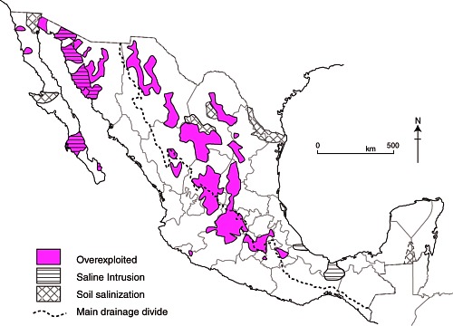
Map of overexploited aquifers and areas of salinization

Overexploited aquifers and areas of salinization (Fig 6-7 of Geo-Mexico; all rights reserved)

According to the National Water Commission, 104 of the country’s 653 identified aquifers are overexploited in that more water is withdrawn each year than is naturally replaced. The velocity of water movements underground can be astonishingly slow; it may take rainwater water tens or even hundreds of years to reach the aquifer it is replenishing. (For a curious case of replenishment rates, see The Enchanted Lake).

The number of overused aquifers has increased rapidly in recent decades from 32 in 1972, to 80 in 1985, and 104 in 2004. When coastal aquifers are over-exploited, seawater seeps in to replenish the aquifer, and eventually the aquifer can become too salty to be used for irrigation. Salt-water intrusion is a significant problem for 17 aquifers located in Baja California, Baja California Sur, Colima, Sonora and Veracruz (see map).

Nearly 60% of the total groundwater extracted is withdrawn from overexploited aquifers. As expected,  the over-exploited aquifers are in the heaviest populated and the most arid areas. Total water extraction exceeds recharge in Mexico City, Monterrey and other large northern metropolitan areas as well as irrigated areas of Sonora, the central northern plateau, the Lerma basin and Baja California.

Related posts:

Mexico’s water resources and water-related issues are the subject of chapters 6 and 7 of Geo-Mexico: the geography and dynamics of modern Mexico. Ask your library to buy a copy of this handy reference guide to all aspects of Mexico’s geography today! Better yet, order your own copy…

Which cities have the best and worst water systems in Mexico?

 Books and resources  Comments Off on Which cities have the best and worst water systems in Mexico?
Aug 182011
 

The Water Advisory Council (CCA), a Mexican NGO specializing in water research, education and policy, has published its 2011 report on Mexico’s water management, sewerage and sanitation. The report looks at data for 50 Mexican cities, each of which has a population in excess of 250,000.

The report —Gestión del Agua en las Ciudades de México (Water Management in Mexican Cities)— uses data for 20 variables to develop the following 10 indicators: drinking water coverage; drainage and sewerage coverage; continuity and extension of services; productivity; metering; physical efficiency; business efficiency; operating income; wastewater treatment; and institutionalization.

In terms of overall performance, the city of León came top, followed by Saltillo, Monterrey, Mexicali, Aguascalientes, Cancún and Tijuana. Of the top six, three (Saltillo, Aguascalientes and Cancún) are managed by private operators, while León, Mexicali and Tijuana are public water systems. There is clearly no discernible difference between the performance of private operators and the best public systems. Towards the bottom of the rankings, all the cities have public water systems. The worst-ranking cities include several in the State of Mexico, as well as others in the south and southeast of the country.

For water quality, the leader was Ciudad Victoria, followed by Colima, Monterrey, León, Torreón, Tepic and Hermosillo. The ten worst were Villahermosa, Cuernavaca, Acapulco, Oaxaca, Xalapa, Chetumal, Chilpancingo, Celaya, Chimalhuacán and Campeche.

For efficiency, the leader was Saltillo, followed by León, Monterrey, Tijuana and Aguascalientes. The least efficient were Ecatepec, Campeche, Villahermosa, Celaya, Chilpancingo and Chimalhuacán.

The report says that where the private sector is involved, the important issues are transparent tenders; clear, balanced and flexible contracts; effective controls to prevent abuse; legal certainty; and effective regulation with stable, long-term regulating agencies.  The authors also emphasize the importance of pricing that reflects costs, and of removing the payment exemptions currently given to government agencies.

The Water Advisory Council argues that the Federal Agency for Environmental Protection (PROFEPA) should be in charge of all water monitoring, though its powers need strengthening to ensure it can fully carry out its mandate.

Could Southern California’s water woes be eased by a desalination plant in Mexico?

 Mexico's geography in the Press  Comments Off on Could Southern California’s water woes be eased by a desalination plant in Mexico?
Aug 042011
 

Southern California water officials are reportedly considering helping to finance a desalination plant in Mexico as a partial solution to their on-going water issues.

A desalination plant proposed by San Diego County Water Authority and Metropolitan Water District of Southern California, and planned for north of the border in Carlsbad (San Diego County) has been tied up in lawsuits and permitting problems for over a decade. As a result, three states—California, Arizona and Nevada—originally approached Mexico about sharing a desalination plant.

Now, however, the San Diego County Water Authority and Metropolitan Water District of Southern California have proposed a new plant located in Rosarito, Baja California, across the border from San Diego. The plant would have a capacity of 284,000 cubic meters (75 million gallons) of water a day to serve communities on both sides of the border. Construction could begin as early as 2013, at an estimated total cost of $1 billion (one-third of which would be contributed by Mexico).

The proposal has been roundly condemned by several environmental groups, who claim it is an attempt to legitimize the unsustainable usage of water in southern California, while simultaneously destroying marine life off the coast of Baja California.

Related post:

Mexico’s water resources and water-related issues are the subject of chapters 6 and 7 of Geo-Mexico: the geography and dynamics of modern Mexico. Ask your library to buy a copy of this handy reference guide to all aspects of Mexico’s geography today! Better yet, order your own copy…

Mexico D.F. administration offers amnesty to illegal water users

 Mexico's geography in the Press  Comments Off on Mexico D.F. administration offers amnesty to illegal water users
Jul 202011
 

According to a recent report in Ooska News (8 June 2011), Mexico City authorities have announced an amnesty for people who regularize illegal water connections. No fines will be levied, and they will be encouraged to pay only 600 dollars (a 50% discount) for registering connections and connecting to the waste water drainage network.

There are believed to be at least 250,000 illegal connections in Mexico D.F. Legislators hope that about half of these will take advantage of the amnesty program.

In the neighboring State of México, the National Association of Water and Sanitation (ANEAS) estimates that 60% of water connections in that area are also  illegal. ANEAS claims that 38% of all water in Mexico is lost through leaks in supply systems, including domestic connections, and a further 20% is lost because of illegal connections.

Related posts:

Less water available each year in Mexico as population increases

 Updates to Geo-Mexico  Comments Off on Less water available each year in Mexico as population increases
Jul 052011
 

Data from the National Statistics Institute (INEGI) show that Mexico’s available water has fallen to 4,263 cubic meters/person/year. Water availability depends on the amount of rainfall received each year and on total population. Mexico’s water availability has declined rapidly since 1950, when it was 18,053 cubic meters/person/year. Of 177 countries analyzed by the Food and Agriculture Organization (FAO), Mexico ranked 90th in terms of water availability.

According to INEGI, Mexico’s total current demand for water nationwide is 78.4 billion cubic meters/year, 11.5 billion more than natural replenishment rates. The drainage basins facing the most severe shortfalls are the Lerma basin in central Mexico, and the Río Grande in northern Mexico.

On the positive side, Mexico reached its UN Millennium Development Goal target for access to water 10 years early, by reducing the percentage of population without access to water in their homes from 25% in 1990 to less than 8% in 2010.

Mexico has also already met its target for improving access to wastewater drainage, where the proportion of the population lacking access to sewage systems has fallen from 37% in 1990 to 10% in 2010.

Mexico’s water resources and water-related issues are the subject of chapters 6 and 7 of Geo-Mexico: the geography and dynamics of modern Mexico. Ask your library to buy a copy of this handy reference guide to all aspects of Mexico’s geography today! Better yet, order your own copy…


The availability of water in Mexico

 Excerpts from Geo-Mexico  Comments Off on The availability of water in Mexico
Jul 042011
 

Though parts of northern Mexico are arid, the country as a whole receives an average of 760 mm of precipitation a year (slightly over 30 in). This is a considerable amount, more than that received by either Canada or the USA. However, 73% of Mexico’s rainfall either evaporates directly or or is lost from plants via evapotranspiration. About 25% runs off into rivers and lakes. Only roughly 2% seeps down to recharge subterranean aquifers.

Consumption of water, by sector

Consumption of water, by sector © Tony Burton / Geo-Mexico, 2010; all rights reserved

Availability of water per person is a function of population size and the total amount of water available. Though Mexico gets more rain than the USA or Canada, the availability of water per person in Mexico is only one-twelfth that of Canada and about half that of the USA because Mexico’s population density is far higher. In other words, though each square kilometer in Mexico receives more rain on average, that rain must be divided among more people. Of 177 countries analyzed by the FAO, Mexico ranked 90th in terms of water availability per person. However, if Mexico is divided into two zones, the south would rank 51st and the north would rank 131st.

Within Mexico, the Lerma Basin (between Mexico City and Guadalajara) has only about 1/3rd the national average for water availability, while the very heavily populated Valley of Mexico (containing the Mexico City Metropolitan Area) has only 1/30th the national average.

Mexico’s per person consumption of water is about half that of Canada but with proportionately more allocated to agriculture. Nationally, about 75% of water consumption is used in agriculture, while settlements and industry use about 17% and 8% respectively.

Mexico’s water resources and water-related issues are the subject of chapters 6 and 7 of Geo-Mexico: the geography and dynamics of modern Mexico. Ask your library to buy a copy of this handy reference guide to all aspects of Mexico’s geography today! Better yet, order your own copy…

USA agrees to “bank” some of Mexico’s entitlement of Colorado River water

 Mexico's geography in the Press  Comments Off on USA agrees to “bank” some of Mexico’s entitlement of Colorado River water
Jan 222011
 

In an earlier post, we described a 1944 treaty that guaranteed Mexico would receive at least 1750 million cubic meters of water  each year along the Colorado River (via the Morelos diversionary dam in the Mexicali Valley). However, in April 2010, the Mexicali area was rattled by a large earthquake, so powerful that it moved the southern part of California,  and severely damaged the irrigation infrastructure used by Mexican farmers on land in the lower Colorado River valley and the Colorado River delta. In all, 640 kilometers of irrigation canals were damaged, affecting 60,000 hectares of farmland.

The damaged infrastructure meant that Mexico was unable to use effectively its total annual allocation of water. Even as urgent repairs were begun on pumps, pipelines and irrigation channels in the Mexicali region, Mexican authorities opened talks with the USA to discuss the possibility of deferring receipt of  some of their annual water quota.

The two governments have now agreed “Minute 318” which permits Mexico to decrease its consumption from 2010 to 2013 and then receive the “saved” water later when the irrigation channels are all operational again.

Another major related development concerning the Colorado River is also now getting underway. The two governments are starting talks this year towards a comprehensive new long-term bilateral agreement covering the management of the Colorado River.

Mexico’s water resources and water-related issues are the subject of chapters 6 and 7 of Geo-Mexico: the geography and dynamics of modern Mexico. Ask your library to buy a copy of this handy reference guide to all aspects of Mexico’s geography today! Better yet, order your own copy…

New aqueduct should guarantee water supply for the city of Hermosillo

 Mexico's geography in the Press  Comments Off on New aqueduct should guarantee water supply for the city of Hermosillo
Jan 082011
 

According to press reports, construction is underway of the “Independence Aqueduct” which will carry water from the Plutarco Elías Calles reservoir on the Yaqui River, in southern Sonora, to Hermosillo, the state’s capital city. The reservoir is the 11th largest in Mexico with a capacity of 2,925 million cubic meters.

Javier Gándara Magaña, the mayor of Hermosillo (population 780,000), expects the 150-km-long aqueduct to be functioning by 2012 though he has warned residents that water brought from the reservoir (commonly known as El Novillo) will be more expensive than that from existing sources. City authorities plan to have installed water meters in every dwelling prior to the completion of the aqueduct.

novillo dam sonora

Curtain of El Novillo dam, Sonora

The aqueduct will supply 75 million cubic meters a year to the city, and represents a long-awaited, and long-term, solution to the water problems faced by Hermosillo, which is located in one of the driest regions of the country. At a later stage, the reservoir will also supply 500 million cubic meters a year to the municipality of Cajeme, in the northwest of the state.

Construction of the aqueduct is opposed by many members of the indigenous Yaqui communities and by agricultural producers farming the Yaqui Valley in the south of Sonora who claim that diverting water to Hermosillo will jeopardize the long-term water security for their operations.

Rivers, reservoirs and water-related issues are discussed in chapters 6 and 7 of Geo-Mexico: the geography and dynamics of modern Mexico. Ask your library to buy a copy of this handy reference guide to all aspects of Mexico’s geography today! Better yet, order your own copy…