Apr 112016
 

According to ECOCE, a non-profit environmental grouping of 24 food and beverage firms, representing more than 80 brands such as Peñafiel, Bonafont, Herdez, Jumex and Coca-Cola, Mexico is the world’s leading recycler of hard plastic PET (polyethylene terephthalate) bottles and containers.

Mexico has 14 PET recycling plants, the construction of which represents total investments of around US$314 million.

Ever wondered what thousands and thousands of crushed plastic bottles look like? Try this short video showing the processes involved in a PetStar PET-recycling plant:

In 2015, Mexico produced 722,000 metric tons of PET, of which 364,000 tons (50.4%) were recovered for recycling. This rate of recycling is well ahead of Canada (40%), Brazil (42%), the U.S. (31%) and the European Union (21%). Recycled PET, worth about $250 a ton, is reused to make bottles, containers, and various textile products.

60% of Mexico’s recycled PET is destined for the national market, the remaining 40% is exported to China, the U.S. and elsewhere.

Source:

  • Press release of ECOCE, 16 March 2016

Related posts:

The world’s first ecological museum was designed and built in Mexico

 Other  Comments Off on The world’s first ecological museum was designed and built in Mexico
Apr 042016
 

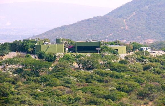
The world’s first ecological museum was designed and built in Mexico, at the archaeological site of Xochicalco, in the state of Morelos. The museum, about thirty kilometers south of Cuernavaca, was built as part of Mexico’s celebrations to commemorate the 500th anniversary of the voyage of Christopher Columbus.

The project, which overs 12,676 square meters, was begun in 1993. Basic construction was completed in 1994 and the museum was formally inaugurated in April 1996.

Xochicalco is an interesting archaeological site, best known for its astronomical significance. Some archaeologists have made a case that its most lavishly-decorated pyramid commemorates a major conference of astronomers, held here in the eighth century AD, in order to plan a calendar adjustment.

At Xochicalco, the scenic and imposing ruins visible today reflect only a small part of what was formerly a much more extensive city. Numerous constructions, linked by cobblestone tracks, rise above the platforms; they include palaces, temples, ball courts and more than one “observatory”.

Xochicalco remained prominent until about AD1000, after which it was abandoned. When the Spaniards arrived in the sixteenth century, they learned of the ruins, but had no inkling of their astronomical significance.

Two of the many natural underground caves at Xochicalco show clear evidence of architectural modification, with the perforation of an artificial hole or “chimney” from the cave to the ground above. These vertical shafts enabled very precise celestial observations. For instance, the vertical north side of the five-meter-long chimney down into one cave would have resulted in a precisely vertical beam of sunlight on the days the sun is directly overhead.

Xochicalco was declared a UNESCO World Heritage site in 1999 and receives about 800,000 visitors a year.


Xochicalco site museum

Xochicalco site museum

The challenge in building the museum is that there is no established settlement near the archaeological site, so there was no local provision of potable water, drainage or electricity.

As a result, the local Mexican architect, Rolando J. Dada y Lemus, designed a building that was almost entirely self-sufficient.

The project, which is fully wheelchair accessible. had three components:

  • Access, parking and exterior gardens, covering 4,550 square meters
  • Entrance patio and three interior gardens, 1,237 square meters
  • Six covered exhibition rooms connected to an entrance hall which has a view of the site, restaurant, administrative and service areas, 1,870 square meters

The museum has parking for 70 cars and 14 buses, and can accommodate 600 people at a time.

How is this museum so sustainable?

  • Underlying the museum is a 550,000-liter cistern. For a few months during the winter dry season, water has to be trucked in from a nearby reservoir – this is the only “input” from outside.
  • The museum’s interior temperatures remain moderate all year because there is a 20-cm gap between exterior and interior walls. When exterior walls heat up in summer, that heat has little effect on the temperature of the interior walls.
  • Shallow outdoor pools around the perimeter cool outside air before it enters the building.
  • Skylights, used to illuminate the exhibits, also allow warm air inside the building to escape.
  • Photo-voltaic solar panels provide sufficient power for computers, lights, and the cistern pump.
  • Rainwater is captured and utilized for much of the year.
  • Wastewater is treated and used to water the gardens

The museum cost 6 million pesos to build, but the energy savings alone mean that all that cost has already been “recuperated”. (Similar size museums have electricity bills of around 1 million pesos a year)

Sources:

  • Rolando Dada y Lemus, Armando Deffís. Arquitectura: 2001 a 2010: 2007: Edificios ecológicos autofinanciables.
  • El Primer Museo Ecológico Del Mundo En México (MexicoAlterno.com, 24 May 2013)
  • Aveni, Anthony F. (1980) Skywatchers of Ancient Mexico. University of Texas Press.
  • Morante, Rúben B. (1989) “La Gruta del Sol”. México Desconocido, No. 147 (May), pp.17-20.

Potential locations for Green Cities in Mexico

 Other  Comments Off on Potential locations for Green Cities in Mexico
May 312014
 

Following on from our look at the feasibility and practicality of establishing sustainable, accessible Green Cities in Mexico, this post seeks to identify the best locations in Mexico for Green Cities based on an analysis of the natural resources of wind, solar and water.

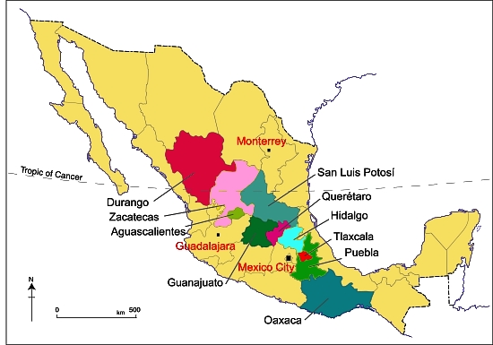
Of the 31 states in Mexico, only ten were evaluated in detail. Twelve were not evaluated due to their current social conflicts. Seven others were not evaluated because of their propensity for hurricanes, and two were not evaluated due to their mountainous terrain, which is not favorable for generating energy from the wind. The remaining ten states were evaluated using maps similar to those in our previous post about Green Cities.

Green-Cities-States

Of the ten states evaluated (see map), two were rated as having the “Best” wind and solar. But, of the two, Tlaxcala has the best overall ratings of wind, solar and moisture. The best locations in Tlaxcala are in the north and northeast areas of the state. Two other states have a wind and solar rating of “Better”, and three are rated “Good.” Three more have a rating of “Poor.” See the summary chart below.

Summary chart of wind, solar, moisture by state:

Summary chart of wind, solar, moisture by state. Individual ratings: 0 = Poor, 1 = Good, 2 = Better, 3 = Best, 4 = Excellent

State Wind Solar Moisture Total
Tlaxcala 3.3 2.0 2.4 7.7
Oaxaca 2.0 2.0 3.1 7.1
Aguascalientes 3.4 2.0 1.0 6.4
Hidalgo 2.1 1.9 1.7 5.7
Zacatecas 2.7 2.0 0.9 5.6
San Luis Potosí 2.6 1.9 1.0 5.5
Guanajuato 2.2 2.0 1.2 5.4
Puebla 1.1 1.8 2.4 5.3
Querétaro 1.4 2.0 1.0 4.4
Durango 1.0 2.3 1.0 4.3


Recommendation:

The recommendation is to do additional evaluations on Tlaxcala, Guanajuato, Hidalgo and Oaxaca, all of which have potential areas suitable for a Green City. Aguascalientes, Zacatecas and San Luis Potosí have good wind and solar ratings, but low moisture ratings which could be a problem. But, they could also be acceptable if suitable “Air to Water” technology were available.

May 242014
 

This guest post, by C.G. Machlan of the fledgling Green City Development Organization, looks at the feasibility and practicality of establishing sustainable, accessible cities in Mexico.

If it is feasible and practical to build wind farms in Mexico then it must also be feasible and practical to build sustainable, accessible Green Cities. Here’s why!

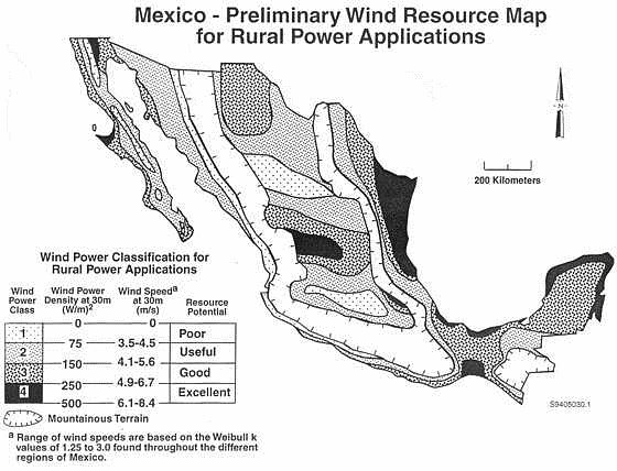
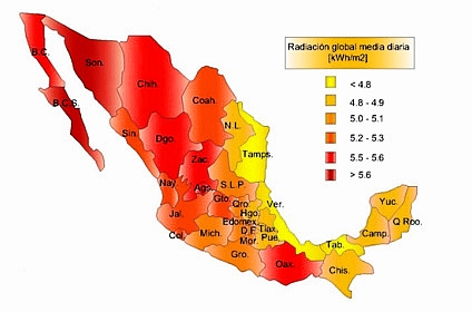
Mexico has sufficient wind and solar resources as indicated by these two maps, of wind resource and solar radiation respectively:

Mexico-Wind-Map-2

Source: http://www.altestore.com/howto/images/article/Mexico-Wind-Map.jpg

energia-solar-mexico

Source: http://www.evwind.com/wp-content/uploads/2013/03/energia-solar-mexico.jpg

Wind Farms

Mexico has approximately 31 wind farms occupying over 11,000 hectares in 8 states, generating more than 1,300 megawatts (MW) of power for the national grid system. Additional wind farms are in the planning and development stages. These wind farms are needed, and are an important component of efforts to increase Mexico’s electricity-generating capacity. Wind farms are ecologically clean, produce needed electricity for the national grid, reduce Mexico’s carbon footprint, and create some long term jobs.

Green Cities versus Wind Farms

While wind farms contribute to Mexico’s electricity-generating capacity they do little to help the long term employment situation in Mexico. On the other hand, Green Cities can help boost employment. The Green City Feasibility Study looked at 10 Mexican states and identified potential locations having sufficient wind, solar and moisture resources to support a Green City. When built, each city would be able to house an estimated population of 250,000 to 300,000, and could create more than 100,000 new jobs across all sectors. Each city would be totally sustainable as regards electricity, by incorporating vertical and horizontal wind turbines together with solar panels in both residential and non-residential areas.

The Green City Electrical Analysis suggests that a Green City will require 54.6 to 63.3 megawatts daily for an estimated 54,000 houses, and between 288 and 661 MW for the non-residential areas at the projected mean and maximum population levels. This is a similar number of megawatts to the 250 MW produced by the Eurus Wind farm located in Juchitan de Zaragoza, Oaxaca, or the 632 MW, oil fired, Puerto Libertad power plant in Pitiquito, Sonora, but has the very important additional advantage of helping to create more than 100,000 new jobs in each city.

Green City Water Sustainability

Both electricity and water are essential for any city, Green Cities included, to grow and prosper. If Green Cities are located in areas where there is good wind speed/density and sufficient solar radiation to produce the electrical energy required, then the next question becomes, “Is there enough water available?”

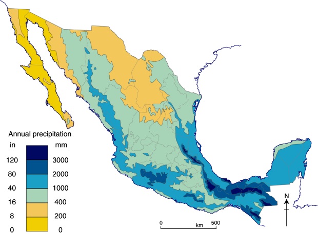
Annual precipitation in Mexico (Fig .4.3 of Geo-Mexico)

Annual precipitation in Mexico (Fig .4.3 of Geo-Mexico, the geography and dynamics of modern Mexico) All rights reserved.

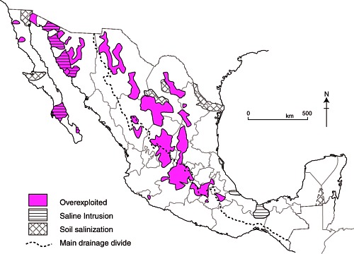
The normal rainfall season in many areas of Mexico is from May through September, so Green Cities would need to rely on aquifers as a year-round water source. Mexico has 653 identified aquifers, more than 100 of which are said to be overexploited.

Map of overexploited aquifers and areas of salinization

Overexploited aquifers and areas of salinization (Fig 6-7 of Geo-Mexico; all rights reserved)

Fortunately, Green Cities can be totally water sustainable by:

  • Recycling all wastewater to a quality suitable for potable use.
  • Incorporating “Air to Water” methods to obtain replacement water thus reducing aquifer usage.
  • Designing runoff systems to collect and clean rainfall (stormwater) when it is available.
  • Recharging aquifers, using excess water obtained from stormwater runoff.

The Green City Water Analysis estimates that a typical Green City will consume 71,563 cubic meters of water daily. Of this amount, 48,904 cubic meters will become wastewater requiring treatment. Assuming that 10% of the wastewater is lost during processing, approximately 24,925 cubic meters of replacement water will be needed daily, which must come from an aquifer, rainwater and/or “Air to Water” methods.

Calculations indicate each city could be fully water sustainable if rainwater was efficiently harvested. Assuming 10 cities were built in the various locations identified in the feasibility study (examined in an upcoming post) as much as 128 million cubic meters of water could be available for aquifer recharging each year.

Accessibility for All Individuals

If new cities are to be built it seems logical to make them completely accessible to all individuals so everyone has equal opportunity to live, learn and work. This, too, is possible with Green Cities. All houses and non-residential buildings are designed to be totally accessible, making the cities not only unique in Mexico, but in the world!

In Closing

It is feasible, socially acceptable, and economically practical to build sustainable, accessible Green Cities in Mexico! Green Cities are especially important for Mexico. Like most other emerging and developing countries, Mexico lacks sufficient electricity-generating capacity to promote the industrial growth needed for its population. Building more wind farms can help existing cities (via the national grid) but Green Cities can provide even more long term benefits to the people of Mexico, including as many as 1 million new jobs from the construction of 10 new cities.

The technology is available. Now it requires planning, refinement, cost analysis and implementation. Is Mexico ready? We believe the answer is YES!

[Text submitted by C.G. Machlan, The Green City Development Organization (GCID.org). Mr. Machlan can be contacted via bmachlan@hotmail.com]

Join the Discussion

As always, Geo-Mexico welcomes discussion about this (and all our posts) via the comments feature. If the comments feature is not visible, simply click the title of the relevant post, and scroll down.

Water management progress in the Lerma-Chapala basin

 Books and resources  Comments Off on Water management progress in the Lerma-Chapala basin
Jan 112014
 

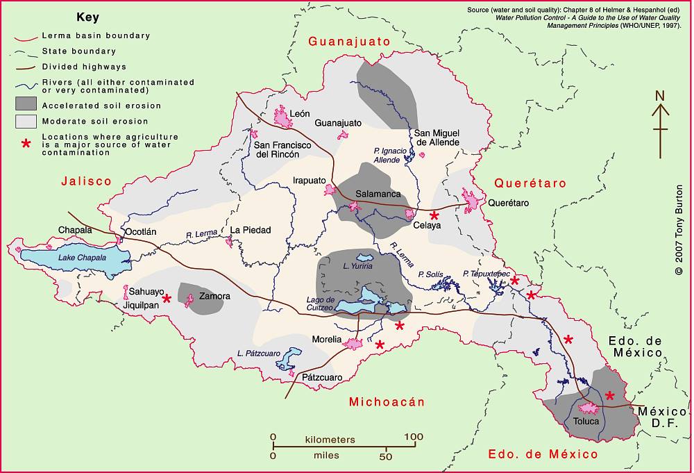
The Lerma-Chapala Basin (see map) is one of Mexico’s major river systems, comprising portions of 127 municipalities in five states: México, Querétaro, Michoacán, Guanajuato and Jalisco.

The basin has considerable economic importance. It occupies only 2.9% of Mexico’s total landmass, but is home to 9.3% of Mexico’s total population, and its economic activities account for 11.5% of national GDP. The basin’s GDP (about 80 billion dollars/year) is higher than the GDP of many countries, including Guatemala, Costa Rica, Honduras, Paraguay, Bolivia, Uruguay, Croatia, Jordan, North Korea and Slovenia.

Lerma-Chapala Basin

The Lerma-Chapala Basin. Click map to enlarge. Credit: Tony Burton / Geo-Mexico

Given this level of economic activity, it is probably not surprising that the pressures on natural resources in the basin, especially water, are enormous. Historically, the downstream consequence of the Lerma Basin’s agricultural and industrial success has been an inadequate supply of (heavily polluted) water to Lake Chapala.

Following decades of political inactivity or ineffectiveness in managing the basin’s water resources, solid progress finally appears to have been made. Part of the problem previously was a distinct lack of hard information about this region at the river basin scale. The statistics for such key elements as water usage, number of wells, replenishment rates, etc. were all (to put it politely) contested.

Fortunately, several scientific publications in recent years have redressed the balance, and the Lerma-Chapala Basin is now probably the best documented river basin in Mexico. This has allowed state and federal governments to negotiate a series of management agreements that are showing some positive signs of success.

The first of these key publications was “The Lerma-Chapala Watershed: Evaluation and Management“, edited by Anne M. Hansen and Manfred van Afferden (Klewer Academic/Plenum Publishers, 2001). This collection of articles featured contributions from researchers in several universities and research centers, including the University of Guadalajara, Mexican Institute of Water Technology, Autonomous University of Guadalajara, Baylor University, the Harvard School of Public Health and Environment Canada. Click here for my comprehensive description and review of this volume on MexConnect.com.

Perhaps the single most important publication was the Atlas de la cuenca Lerma-Chapala, construyendo una visión conjunta in 2006. Cotler Ávalos, Helena; Marisa Mazari Hiriart y José de Anda Sánchez (eds.), SEMARNATINE-UNAM-IE, México, 2006, 196 pages. (The link is to a low-resolution pdf of the entire atlas). The atlas’s 196 pages showcase specially-commissioned maps of climate, soils, vegetation, land use, urban growth, water quality,  and a myriad of other topics.

More recently, a Case Study of the Lerma-Chapala river basin: : A fruitful sustainable water management experience was prepared in 2012 for the 4th UN World Water Development Report “Managing water under uncertainty and risk”. This detailed case study should prove to be especially useful in high school and university classes.

The Case Study provides a solid background to the Lerma-Chapala basin, including development indicators, followed by a history of attempts to provide a structural framework for its management.

In the words of its authors, “The Lerma Chapala Case Study is a story of how the rapid economic and demographic growth of post-Second World War Mexico, a period known as the “Mexican Miracle”, turned into a shambles when water resources and sustainable balances were lost, leading to pressure on water resources and their management, including water allocation conflicts and social turbulence.”

On a positive note, the study describes how meticulous study of the main interactions between water and other key development elements such as economic activity and social structures, enabled a thorough assessment on how to drive change in a manner largely accepted by the key stakeholders.

The early results are “stimulating”. “Drawbacks and obstacles are formidable. The main yields are water treatment and allocation, finances, public awareness, participation and involvement. The main obstacles are centralization, turbid interests, weak capacity building, fragile water knowledge; continuity; financial constraints; and weak planning.”

Sustainable water usage is still a long way off. As the Case Study cautions, “There is still much to do, considering the system Lerma-Chapala responds directly to a hydrologic system where joint action and especially abundant involvement of informed users is required, to achieve sustainable use of water resource.”

One minor caveat is that the Case Study does not offer full bibliographic reference for all of the maps it uses, which include several from the previously-described Atlas de la cuenca Lerma-Chapala, construyendo una visión conjunta.

Related posts:

Update on Mexico and the UN Millennium Development Goals (MDGs)

 Mexico's geography in the Press  Comments Off on Update on Mexico and the UN Millennium Development Goals (MDGs)
Dec 302013
 

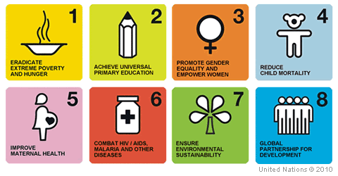
More than 190 countries signed up to the 2015 UN Millennium Development Goals (MDGs), agreed in 2000. There are 8 major goals:

  1. eradicate extreme poverty and hunger
  2. achieve universal primary education
  3. promote gender equality and empower women
  4. reduce child mortality
  5. improve maternal health
  6. combat HIV/AIDS, malaria and other diseases
  7. ensure environmental sustainability
  8. develop a global partnership for development

millenium-development-goalsMexico is well on its way to meeting most of the eight goals, according to the technical committee established to monitor the country’s progress. The technical committee includes representatives from various government departments, as well as INEGI (the National Geography and Statistics Institute) and CONAPO (the National Population Council).

The committee reports that Mexico has already met the targets for 38 (74.5%) of the 51 quantitative indicators used to assess progress towards the 8 goals, and is continuing work towards meeting the remaining targets by 2015 (the deadline for the Millennium Development Goals).

Satisfactory or good progress is being made on 5 of the remaining 13 indicators; all five are expected to be met sometime in 2015.  Progress on the other 8 indicators has been slower than needed, and it now seems highly unlikely that goal 7 (environmental sustainability) can possibly be met.

Specific targets that Mexico has not yet reached and where progress has either stagnated, or deterioration has occurred, include:

  • Decrease in mortality rate per 100,000 inhabitants due to HIV/AIDS  (part of goal 6)
  • Total carbon dioxide emissions (part of goal 7)
  • Proportion of total water resources already in use (part of goal 7)
  • Percentage of inhabitants with private dwellings using charcoal or wood for cooking (part of goal 7)

Related posts:

Exclusive: Quintana Roo cacao megaproject collapses

 Other  Comments Off on Exclusive: Quintana Roo cacao megaproject collapses
Aug 302013
 

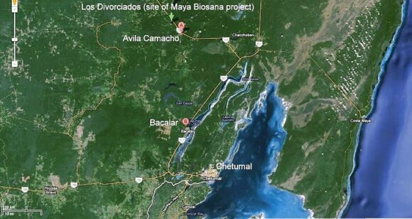
Following our critique of the Maya Biosana chocolate megaproject (Maya Biosana or Maya Bio-Insana? Chocolate megaproject in Quintana Roo),  a project which claimed it would plant four million cacao plants in four years, we have received additional information about developments in the Los Divorciados ejido where the project is based.

According to an insider, the project has now completely abandoned its plans for a massive cacao plantation. Jim Walsh, the former CEO of Maya Biosana, left the project in December 2012. Maya Biosana is now being managed by a Mexican firm AMSA (Agroindustrias Unidas de México, S.A. de CV) which is trying to convert the land into a profit-making venture producing corn and other grains.

Prior to the demise of the cacao megaproject, the organizers of Maya Biosana had released a short documentary detailing the project, and lauding its successful transformation of “a dwindling Mayan town” into a “now blossoming entrepreneurial city growing cacao fields and supporting their local community.” The film’s blurb claims that since the video was filmed, “the town has expanded and grown two-fold.”

According to recent visitors to Los Divorciados (the ejido in question—see map), this could not be further from the truth. They report that in summer 2013, the Maya Biosana project, which had started out by employing around 200 people, now had 40 workers at most. One member of the group that visited Maya Biosana estimates, “based on the number of motorcyles parked there when we were there”, that the real workforce at Maya Biosana may be even smaller, perhaps 20-25.

Google Earth image of southern Quintana Roo

Google Earth image of southern Quintana Roo

The 13-minute documentary, “Maya Biosana – The Rebirth of Mexican Cacao, A short documentary,” can still be seen (as of August 2013) via http://intentionalchocolate-blog.com/2013/07/17/maya-biosana-the-rebirth-of-mexican-cacao-a-short-documentary/ on the Intentional Chocolate blog. However, note that many of the images included in the video are most definitely NOT from the Maya Biosana area, or even from Quintana Roo.

The film’s badly-written blurb claims that it, “follows Maya Biosana, as it repositions Mexico as the largest organic cocoa producer in the world and bringing the sacred plant back to it’s birth home. Improving the quality of life in Mexico with it’s vision of collaboration, co-creation and intention by providing the local and surrounding communities with a new model of business utilizing their own proprietary Well Being index as the marker of change.”

According to the Intentional Chocolate blog, “The film won the best short Award in 2012 at the Awareness Festival”, a claim it has also proved impossible to verify.

The original Maya Biosana is no more, but will the new management of this area by AMSA prove to be any better for the local ejidatarios than the original megaproject fiasco? We certainly hope so, but only time will tell.

In the interim, we received an e-mail  a few weeks ago about a new megaproject underway in Avila Camacho, the next village to Los Divorciados (see map). Apparently, this megaproject is for plantations of exotic trees, which involves deforesting the jungle, extracting the wood, and planting a total of 6000 hectares with White Teak (Gmelina arborea, Spanish common name melina), a tropical hardwood, at the rate of 1000 hectares a year. So far, about 50 hectares have already been planted.  The correspondent writes that they “stole the land of the Mayan people, cheating about the pay of rent: the rent is $45US for a hectare for a year. They are destroying the jungle  and extracting the wood.” We have been unable to get independent verification of these claims as yet, but will continue attempting to do so.

Initially, some equipment from Maya Biosana was utilized on the Avila Camacho project, and our correspondent  claims that it is the same Mexican-associated company that is responsible, though we have not yet been able to confirm this.  According to a second source, the CEO of this project is Fernando Gonzalez, a “very good friend of Jim Walsh”, the former CEO of Maya Biosana, but there is no longer any direct connection between the two projects.

There may have been recent “developments” in this part of Mexico, but they certainly do not yet constitute any form of sustainable development.

Related posts:

Mexico and the Environmental Sustainability Index

 Excerpts from Geo-Mexico  Comments Off on Mexico and the Environmental Sustainability Index
Jun 132013
 

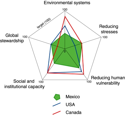
Environmental sustainability is a highly politicized term which almost all nations now eagerly claim as one of their goals. How true are these claims? The Environmental Sustainability Index (ESI) combines five major components (see diagram) which include 76 separate measurements in all. It assesses how close countries are to environmental sustainability. The ESI includes the ecological footprint but also looks at levels of pollution, susceptibility to environmental disruptions, the effectiveness of environmental policies and each country’s contribution to global stewardship.

Comparison of ESI components for Mexico, USA and Canada. (Geo-Mexico. Figure 30.5) All rights reserved.

Comparison of ESI components for Mexico, USA and Canada. (Geo-Mexico. Figure 30.5) All rights reserved.

The countries with the highest ESI scores are predominantly resource-rich nations with low population densities, such as Finland, Norway and Sweden. Some small wealthy states such as Switzerland also make the top ten. In general, densely populated countries such as India and Bangladesh do not score as well.

Mexico’s low ranking in the pilot 2000 ESI table led to Mexico’s Environment Secretariat (SEMARNAT) exploring ways to ensure that international organizations such as the World Bank and World Resources Institute had faster access to updated data from Mexico. Government policy was modified to embrace the use of quantitative environmental data relating to sustainability.

In terms of global stewardship, Mexico and the USA are closer to the target for environmental sustainability than Canada (see diagram). For reducing environmental stresses, Mexico and Canada are ahead of the USA. However, for the other three components, Mexico lags well behind both its North American partners.

Related posts:

How does Mexico score on the Social Progress Index?

 Books and resources  Comments Off on How does Mexico score on the Social Progress Index?
May 302013
 

The Social Progress Index measures the extent to which countries provide for the social and environmental needs of their citizens. It is a compound index, based on  52 indicators in the areas of Basic Human Needs, Foundations of Wellbeing, and Opportunity that show relative performance in order to elevate the quality of discussion on national priorities and to guide social investment decisions.

Social progress is the capacity of a society to meet the basic human needs of its citizens, establish the building blocks that allow citizens and communities to enhance and sustain the quality of their lives, and create the conditions for all individuals to reach their full potential.

The model used to develop the index is based on asking three key questions that help define social progress:

  1. Does a country provide for its people’s most essential needs? (Basic Human Needs)
  2. Are the building blocks in place for individuals and communities to enhance and sustain wellbeing? (Foundations of Wellbeing)
  3. Is there opportunity for all individuals to reach their full potential? (Opportunity)

In this inaugural Social Progress Index, each of these dimensions is disaggregated into four components, each measured by between two and six specific indicators. Each indicator has been tested for internal validity and geographic availability:

Criteria used to compile Social Progress Index

Criteria used to compile Social Progress Index. Click image to enlarge.

For example the Personal Rights component of Opportunity is comprised of 5 separate variables:

  • Political Rights (Freedom House)
  • Freedom of Speech (CIRI Human Rights Data Project)
  • Freedom of Assembly/Association(CIRI Human Rights Data Project)
  • Private Property Rights (Heritage Foundation)
  • Women`s Property Rights (Economist Intelligence Unit)

How does Mexico score on the Social Progress Index?

Of issues covered by the Basic Human Needs Dimension, Mexico does best in areas including Nutrition and Basic Medical Care and has the greatest opportunity to improve human wellbeing by focusing more on Personal Safety. Of issues covered by the Foundations of Wellbeing Dimension, Mexico excels at providing building blocks for people’s lives such as Health and Wellness but would benefit from greater investment in Access to Information and Communications. Of issues covered by the Opportunity Dimension, Mexico outperforms in providing opportunities for people to improve their position in society and scores highly in Personal Rights yet falls short in Access to Higher Education.

This is how Mexico’s performance stacks up in comparison to the other 49 countries in the survey:

  • Social Progress Index: score 49.7 = rank 25th
  • Basic Human Needs: 49.3 (29th)
  • Foundations of Wellbeing: 50.8 (23rd)
  • Opportunity: 49.1 (25th)

This post is based on a press release from the Social Progress Imperative. For more information about the methodology behind the Social Progress Index, please refer to the inaugural report.

Related posts:

Environmental news briefs relating to Mexico

 Mexico's geography in the Press  Comments Off on Environmental news briefs relating to Mexico
Apr 022013
 

This post describes several newsworthy developments relating to Mexico’s natural environment.

Financing to fight deforestation

The Inter-American Development Bank is giving Mexico $15 million in financial and technical assistance to support climate change mitigation efforts. The program will help communities and ejidos finance low carbon projects in forest landscapes in five states, all of which have high levels of net forest loss: Oaxaca, Yucatán, Quintana Roo, Jalisco and Campeche.

The program includes a $10 million loan for financing projects that must reconcile economic profit for the communities and generate environmental benefits through reducing the pressure on forests and promoting enhancement of carbon stocks. In addition, a $5 million grant will provide financial and technical assistance to support the viability of individual projects, by strengthening technical, financial and management skills.

The IDB says that the program is a pilot project that will allow lessons to be learned for its replication in other key geographic areas in Mexico. It should demonstrate a viable business model that promotes the reduction of deforestation and degradation while increasing economic returns. [based on an IDB press release]

Mexican company converts avocado seeds into biodegradable plastic

A Mexican company called Biofase has developed a way to turn avocado pits into 100% biodegradable plastic resins. Avocado pits are normally discarded as waste. Biofase will collect some of the estimated 30,000 metric tons of avocado pits discarded each month for processing. The company has patented the technology and is looking for additional raw material containing some of the same chemicals as avocados.

Huichol Indians oppose peyote conservation measure

A presidential decree signed last November prohibits the harvesting of the hallucinogenic peyote cactus from two protected areas in the state of San Luis Potosí. The decree has met fierce opposition from the indigenous Huichol (Wixarika) people, for whom the peyote is a sacred plant. The Huichol undertake a lengthy pilgrimage each year to gather peyote for subsequent use in their ceremonies.

The restriction on peyote harvesting is the latest in a long line of problems faced by the Huichol including the incursion by a large number of mining companies onto traditional territory. The Regional Council for the Defense of Wirikuta has demanded that the government guarantee the Huichol’s right to pick peyote, and called for the cancellation of 79 mining concessions (most of them to Canadian companies) that impinge on their sacred land. Critics claim that mining is having a devastating impact on the local environment, especially because the companies involved are using large quantities of highly toxic cyanide.

Expand the port or protect the coral reef?

In Avalan destruir arrecifes para ampliar puerto de Veracruz published in Mexico City daily La Jornada, Luz María Rivera describes how one of the final acts of the previous administration was to redraw the boundaries of the protected area of coral reef off the coast of Veracruz state. The new boundaries have reduced the protected offshore area near the cities of Veracruz, Boca del Río and Alvarado by about 1200 hectares (3000 acres). The redrawing of the protected area is to enable the expansion of the port of Veracruz, one of the country’s largest, and almost double its capacity. Government officials claimed that the area affected was already “damaged” and that the reef system was 98% or 99% “dead”.

Government-NGO accord to protect Mexican whale sanctuary

The Mexican government has signed an accord with the NGO Pronatura Noroeste to improve the protection of Laguna San Ignacio, the Pacific coastal lagoon which is a major breeding ground for gray whales. The lagoon has 400 kilometers (250 miles) of coastline, bounded by wetlands and mangroves, and is part of the El Vizcaino Biosphere Reserve in the northern part of the state of Baja California Sur. The accord calls for joint development of plans for protection, monitoring and tracking the whales and other species that inhabit the lagoon, as well as  establishing protocols for resolving any eventual environmental contingencies.

Related posts:


How sustainable is organic agriculture on the Baja California Peninsula in Mexico?

 Mexico's geography in the Press, Updates to Geo-Mexico  Comments Off on How sustainable is organic agriculture on the Baja California Peninsula in Mexico?
Jan 192012
 

In recent years, a farming boom has completely changed the landscape in parts of Mexico’s Baja California Peninsula. The new landscape is comprised of organic farms, specializing in growing fresh produce, especially out-of-season, certified organic, fruits and vegetables, which carry premium prices.

“Organic” has come to mean very different things in different countries, but the essential common element is that it uses no synthetic fertilizers, hormones or pesticides. In the USA, the term “organic produce” also requires that farmers protect water resources, though this is hard to define and at least as hard to enforce.

The Baja California Peninsula receives very little rainfall, so irrigation water for its organic farms comes from underground aquifers. The profitability of these new farms relies on the availability of irrigation water and on the proximity of the region to the lucrative US market for organic produce.

The new farms may be “organic”, but the bigger question, examined by Elisabeth Rosenthal in Organic Agriculture May Be Outgrowing Its Ideals, in the New York Times is, “Are these organic farms sustainable?” Rosenthal looks in some detail at whether or not organic farms protect the local environment and the livelihood of local farmers. The article discusses the extreme stress being placed on the area’s ground water reserves. Some farmers are already in trouble because their wells have dried up. More than one-third of aquifers in the southern part of the peninsula are officially classified as “over-exploited”.

Growers blame the area’s tourism industry for the water shortages, arguing that hotels and golf courses gobble up far more than their fair share of the precious resource. Despite the aridity of the southern section of Baja California Peninsula, the southern coast, centered on Los Cabos, has far more golf courses per unit area than anywhere else in the country.

The “organic” label also takes no account of the emissions involved in production and transport of fruits and vegetables to the marketplace; export-oriented horticulture in the Baja Peninsula is an energy-intensive enterprise. Adding to the unsustainable side of the argument, some of the organic farms practice “monoculture”, growing a single crop year after year on the same land, a system known to lead to soil depletion and increase the risk of pest-related problems.

On the other hand, the new farms also provide an alternative source of jobs to tourism. Del Cabo, which has a cooperative packing plant in San José del Cabo and trucks or flies more than 7 metric tons of produce to the USA every day, is able to help its members by supplying high-quality seed, and employing specialists in plant raising and plant diseases who act as consultants to individual farmers as required. Del Cabo criticized the New York Times story for its numerous inaccuracies regarding water usage and sustainability.

Conscious of the water issues, many of these modern organic farms employ sophisticated, water-conserving irrigation systems, such as computerized drip irrigation. They also grow many crops under shade. Such systems are expensive to install and maintain, so most of the bigger producers are US-owned companies.

In Organic Tomatoes in January: Sucking Mexico Dry, in Mother Jones, Tom Philpott compares the situation in Baja California with that in “another region famous for winter tomatoes and dirt-cheap labor costs: Immokalee, Florida, source of a huge percentage of non-organic winter tomatoes consumed in the United States.” Philpott concludes that “What’s going on in Baja seems more about generating a premium-priced product while systematically degrading a landscape. Want organic tomatoes in the cold months? Buy them in a can.”

Food for thought!

Related posts:


Mexico reduces emissions with innovative carbon credit project

 Mexico's geography in the Press  Comments Off on Mexico reduces emissions with innovative carbon credit project
Nov 212011
 

Mexico is rapidly becoming a key market for environmental investments, and now accounts for one in every five projects involving Clean Development Mechanisms (CDMs) in Latin America. A recent Reuters news item gives the basic details of one CDP project:

  • Mexico to earn royalty on light bulb carbon credits

CDMs, established after the Kyoto Protocol, allow companies in developing countries to sell Certified Emission Reduction certificates (CERs) to buyers in industrialized countries, to offset their own emissions control targets. The certificates prove that there has been a reduction in greenhouse gas emissions.

One project involving CERs, started by Australian company Cool nrg International, will reduce Mexico City’s carbon dioxide (CO2) emissions by 16 million tonnes over the next 10 years. The company is distributing 30 million free energy-efficient lightbulbs to 6.5 million low-income households, which will save 33,000 gigawatt hours of electricity.

Watch Nick Francis from Cool nrg explain the plan and why it is a win-win-win for everyone concerned:

Every tonne of CO2 saved generates a CER credit (currently trading at 9 dollars). For every credit, Mexico receives a royalty payment. Cool nrg then sells the CERs to companies in industrialized countries. The project is a world first and its success will be closely monitored by many other countries.

Related posts:


The sustainable management of Mexico’s natural environment, 2006-2008

 Other  Comments Off on The sustainable management of Mexico’s natural environment, 2006-2008
Nov 062010
 

The IMCO report on the competitiveness of Mexico’s states, which we briefly described in an earlier post, includes a significant section devoted to the sustainable management of Mexico’s natural environment.

IMCO’s sustainable management factor incorporates 14 distinct variables. For almost every variable, the average of all 32 state values for that variable has improved between 2006 and 2008. Only 1 of the 14 variables has worsened, and three have remained unchanged.

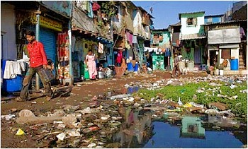
photo of garbage

Sadly, not all garbage finds its way into regulated landfills...

The variable that worsened was the proportion of energy derived from “clean” sources, which fell from 18.9% of the total energy produced in 2006 to 17.6% in 2008.

The three variables that remained unchanged were:

  • the surface experiencing drought or aridity
  • the area where soil degradation is a problem
  • and the number of species considered endangered.

The following 10 variables all showed a significant improvement between 2006 and 2008:

  • the annual rate of reforestation, up from 1.1% to 1.7%
  • the number of “environmental emergencies”, down from 11.3 to 10.9
  • the total area formally protected (biosphere reserves, national parks, etc), which increased slightly
  • the value of agricultural production compared to groundwater consumed for agriculture, which also increased slightly
  • the over-exploitation of aquifers, which fell by more than 10%
  • the volume of sewage (wastewater) that is treated, which rose from 859 liters/sec per million inhabitants to 962 liters/sec
  • carbon dioxide emissions which fell to 0.3 parts/million
  • the percentage of all waste entering regulated landfills, which increased from 58% of all waste to 62%
  • a fall in the total generation hazardous wastes
  • an increase in the number of companies certified as “clean”

In addition, the gap between the top-performing state for this factor (Aguascalientes) and the bottom-performing states (Chiapas and Oaxaca) has closed significantly.

Mexico’s environmental trends and issues are examined in chapter 30 of Geo-Mexico: the geography and dynamics of modern Mexico. Ask your library to buy a copy of this handy reference guide to all aspects of Mexico’s geography today! Better yet, purchase your own copy…

Build-it-yourself wind and solar power for rural Oaxaca

 Mexico's geography in the Press  Comments Off on Build-it-yourself wind and solar power for rural Oaxaca
Sep 212010
 

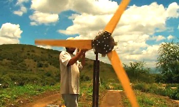
Many remote settlements in the mountains of Oaxaca are still not connected to the national electricity grid. A project based in the municipality of Ejutla (60 km south of Oaxaca City) aims to bring affordable renewable energy to isolated hamlets. The innovative scheme relies on a design for a power-producing wind-vane, complemented by a solar panel for when the wind fails to blow.

Wind power in Oaxaca

Wind power in Oaxaca (still from John Dixie's video)

Constructing the system does not require any specialist materials or equipment, but relies on readily available components. For example, the blades for the wind turbine are made of wood which means they are easy to repair and adjust as needed.

More information?

Mexico’s cultural diversity is discussed in chapters 10 and 13 of Geo-Mexico: the geography and dynamics of modern Mexico. Rural areas are the focus of chapter 24 and development indices of various kinds are discussed in chapters 29 and 30. Ask your local library to purchase a copy today!

The energy efficiency of farming in Mexico and elsewhere

 Other, Teaching ideas  Comments Off on The energy efficiency of farming in Mexico and elsewhere
Aug 302010
 

Corn is one of the world’s major cereal crops and has long been a vitally-important crop to Mexico.

However, is it more efficient in energy terms to be a slash-and-burn farmer of corn in the jungle or a technologically-sophisticated corn farmer on the US or Canadian prairies?

David and Marcia Pimentel have compiled data from a variety of sources and analyzed this question and similar questions in some detail.

In Mexico, they calculated that about 1144 hours of human labor are required to produce 1 hectare (ha) of corn using only hand labor, and no animals or machinery. On the other hand, using machinery, cultivating a hectare of corn requires only 10 hours of labor in the USA.

The total energy required to cultivate a single hectare of corn by hand is 589,160 kcal for the 1144 hours of hand labor, plus 16,570  kcal for making the axe and hoe used by the farmer (this figure assumes a certain lifespan and maintenance needs for such tools), plus 36,608 kcal for the 10.4 kg of seed required. The grand total for energy inputs into the system is 642,336 kcal. [One kcal (kilocalorie) = 4184 joules.]

An average yield for corn in such a non-mechanized system is 1,944 kg/ha, equivalent to 6,901,200 kcal. The ratio between the energy output and the energy expended of this system is almost 11:1.

By way of comparison, the energy inputs (labor, machinery, gasoline, seeds, irrigation, herbicides, etc) in a typical, highly mechanized US or Canadian cornfield total 10,535,000 kcal/ha. The yield of corn is about 7,500 kg/ha, equivalent to 26,625,000 kcal. The energy ratio for this farming system is 2.5:1
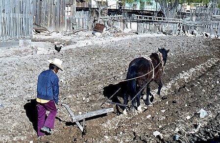
Horse-drawn plough, Creel, Chihuahua, 1980

More efficient than a tractor?

Which system is more efficient? This is where it becomes essential to define what is meant by efficiency. In terms of output per hour of labor, the US farm is far more efficient. In terms of yield per hectare, the US farm is more efficient. However, in terms of energy ratios, the Mexican farm is four times more efficient than its US counterpart.

Looking at energy ratios makes it possible to make various generalizations about farming. In general, hand cultivation methods are the most energy efficient, followed by systems where animals are used, followed by systems based largely on machinery. The precise numbers for any type of farming will vary from one country to another, since the labor required and crop yields do depend to some extent on such geographic factors as soil types, terrain and the weather during the growing season.

It is also possible to look at what the additional energy inputs in a highly mechanized system actually achieve. For instance, in the USA, machinery and fuel account for about 20% of all the fossil energy employed; in other words, about 20% of the energy input reduces, or replaces, human and animal labor. The remaining 80% of fossil fuel inputs is employed in increasing corn yields by means of fertilizers, insecticides, herbicides and irrigation.

The table shows the energy ratios which have been calculated for a selection of crops in various countries.

Type of farmingLocationEnergy ratio (output/input)
CassavaTanzania23.0
Corn (human power)Mexico10.7
Corn (human power)Guatemala4,8
Corn (oxen power)Guatemala3.1
Corn (oxen power)Mexico4.3
Corn (animal power)Philippines5.1
Corn (mechanized)USA2.5
Wheat (bullock power)Uttar Pradesh, India1.0
WheatUSA2.0
Rice (human power)Borneo7.0
Rice (mechanized)Japan3.0
RiceCalifornia2.0
Sorghum (human power)Sudan14.0
SorghumUSA2.0
SoybeansUSA4.0
OrangesFlorida, USA2.0
ApplesEastern USA1.0
PotatoesNew York state, USA1.2
PotatoesUK1.5
TomatoesCalifornia0.6
SpinachUSA0.2
Eggs, batteryUK0.15
CatfishLouisiana, USA0.03
ShrimpThailand0.01
OystersHawaii0.01
Winter lettuce (glasshouse)UK0.0023
All agriculture, 1952UK0.47
All agriculture, 1968UK0.35

An energy ratio below 1.0 for a particular item means that the inputs of energy exceed the output, or in other words more energy is expended on cultivation than is returned via the crop.

As Tim Bayliss-Smith concludes in the The ecology of agricultural systems, the evidence is that, “Only in fully industrialized societies does the use of energy become so profligate that very little more energy is gained from agriculture than is expended in its production.”

Why are energy ratios important?

Energy ratios shed some light on the sustainability of farming. Cultivation relying only on human power, is clearly sustainable virtually indefinitely, provided that land degradation is avoided and yields do not decline. Farming using a mix of animal and human power is also likely to be fully sustainable. However, the same is not true for cultivation relying on power derived from fossil fuels. For mechanized farming, sustainability requires machinery to be powered by renewable sources of energy, such as solar or wind power. Such sources of energy may be impossible to harness in some climatic zones.

Of course, farm systems are not only about energy flows and ratios. As Tim Bayliss-Smith points out, farms ”also provide jobs, incomes and a way of life for agrarian societies, whose social and ideological characteristics cannot be ignored.”

Sources / further reading:

  • Pimentel, David and Pimentel, Marcia H. Food, energy and society (3rd edition) CRC Press, 2008
  • Bayliss-Smith, T.P. The ecology of agricultural systems. Cambridge University Press, 1982.
  • Simmons, I.G. “Ecological-Functional Approaches to Agriculture in Geographical Contexts”, in Geography, 65: 305-316 (Nov. 1980)

Agriculture is analyzed in chapter 15 of Geo-Mexico: the geography and dynamics of modern Mexico. and concepts of sustainability are explored in chapters 19 and 30.  Buy your copy today, so you have this handy reference guide to all aspects of Mexico’s geography available whenever you need it.