Jul 302011
 

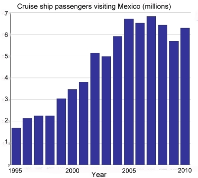
According to data from Mexico’s Tourism Secretariat, the number of cruise ship passengers peaked in 2007, but has since declined, although their average spending has increased. The graph shows the number of passengers arriving on cruise ships to Mexican ports since 1995. This segment of Mexico’s tourism industry grew rapidly between 1995 and 2005.

Cruise ship passengers, 1995-2010

The peak year was 2007 when 6.814 million cruise ship passengers visited Mexico. This was also the year when President Felipe Calderón announced the start of Mexico’s “war against drug cartels”. Since that date, more than 35,000 people have lost their lives in drug-related violence.

The dramatic decline in cruise ship passengers between 2008 and 2009 can be largely attributed to the A-H1N1 flu epidemic, which is thought to have started in Mexico and which brought regional falls in tourist numbers. In 2010, cruise ship passenger arrivals showed signs of recovery, though they remained well below the numbers registered in the peak years from 2005 to 2007. In 2011, the provisional first-quarter figures suggest a slight decline from 2010 numbers.

Security concerns are the main reason for the continued drop in cruise ship passengers visiting Mexico. Earlier this year, Princess Cruises, the major international cruise line, canceled all sailings to Puerto Vallarta and Mazatlán until at least the start of next year. Other cruise lines, including Holland America and Carnival, are also reported to be considering schedule cuts.

The only silver lining in this dark cloud is that the average spending of cruise ship passengers has risen, helping to offset the decline in visitor numbers. It is estimated that cruise ship passengers will contribute about 104 million dollars to Mexico’s economy this year, compared to 112 million dollars in 2007. Even so, the average expenditure per passenger remains very low, certainly below $100 a visit. The average figure has risen over the past few years, but preliminary figures for the first quarter of 2011 reveal that it was still only $91.20 per cruise ship passenger.

Resorts receiving cruise ships need to boost this tourist expenditure figure by offering a wider range of on-shore attractions and attracting higher spending from visitors in order to offset any decline in the number of cruise ship passengers visiting the country. In the long run, the cruise ship sector will only recover fully when drug-related violence is reduced and foreigners’ perceptions of the safety of traveling to Mexico improve.

Related posts:

Chapter 19 of Geo-Mexico: the geography and dynamics of modern Mexico focuses on Mexican tourism and development.  Buy your copy today to have a handy reference guide to all major aspects of Mexico’s geography!

From Morelos to Minnesota; case study of a migrant channel between Mexico and USA

 Other  Comments Off on From Morelos to Minnesota; case study of a migrant channel between Mexico and USA
Jul 262011
 

Axochiapan is a town and municipality in the small state of Morelos in central Mexico. According to the 2010 census, the population of Axochiapan municipality has grown only slowly over the past decade, from 30,436 in 2000 to 33,695 inhabitants in 2010, half of them living in the eponymous cabecera municipal (the main town of the municipality).

One of the more curious things about Axochiapan is that three of every ten people born in the municipality now live in the same small area of Minneapolis in Minnesota, USA.

By 2005, the Minneapolis-St.Paul area already had a large Hispanic community, served by 22 churches offering services in Spanish, 9 Spanish-language newspapers, 3 tortilla makers and 9 Hispanic-mostly Mexican-soccer leagues. It even has a Mexican consulate to serve the growing number of Mexican migrants living there. For more details, see:

As many as one-third of the people born in Axochiapan are thought to have moved to “El Norte” (= USA); it is estimated that 90% of all the families in Axochiapan have representatives currently living in Minneapolis-St.Paul.

According to the 2000 census, 41,600 Mexican-born people lived in Minnesota, compared to only 3,500 a decade earlier. By 2010, the figure had risen to about 68,000.

Mercado Central in Minneapolis

Mercado Central in Minneapolis

East Lake Street in Minneapolis has become a center for Mexican commercial activity, from Mexican butchers and video rentals to jewelry making, travel agents and money exchange offices. The hub of Mexican commerce is the Mercado Central, a member-owned cooperative of 48 Latino businesses opened in 1999.

Why do Mexicans migrate here?

  • Population pressure in Mexico – the 15-40-year-age bracket (the main migrant age groups) is still growing in Mexico and will for the next few years.
  • Economics – poor salaries and few job opportunities persist in rural areas of Mexico such as Axochiapan, despite numerous civic improvements, such as the paving of streets, largely financed by remittances sent home by migrants.
  • Networks of migrants provide support and encouragement for relatives and friends, making it far easier for successful migration and adaptation to life in the USA

Is migration from Axochiapan to Minnesota coming to an end?

There is growing evidence that Mexican migration to the USA is slowing down. If this turns out to be the case, it is probably a combination of the poor US economic performance in recent years, the relative strength of Mexico’s economy during that time, and the increased costs associated with entering the USA as an undocumented worker. In addition, US migration policy seems to be encouraging undocumented workers to remain, rather than return home periodically.

Conclusion? Migration flows such as this one, from Morelos to Minnesota, may currently be weakening, but it is far too early to say whether or not this decline will last for very long.

Related posts:

Migration between Mexico and the USA is the focus of chapter 25 of Geo-Mexico: the geography and dynamics of modern Mexico. Ask your library to buy a copy of this handy reference guide to all aspects of Mexico’s geography today! Better yet, order your own copy…

Mexico has forty UNESCO-designated biosphere reserves

 Other  Comments Off on Mexico has forty UNESCO-designated biosphere reserves
Jul 232011
 

A surprising percentage of Mexico’s land area is protected in one form or another. A very large number of sites of archaeological or historical importance are managed by the National Institute of Anthropology and History, more commonly known by its acronym INAH. In theory, all buildings more than 100 years old have some degree of protection (under INAH), but in practice this protection is often ignored by developers with other ideas.

Sites considered significant for their natural beauty are protected in a variety of ways, ranging from nature sanctuaries of local importance to protected areas, national parks and internationally recognized biosphere reserves. In total, more than 11.5% of Mexico’s land area is now protected. This percentage has risen steadily for more than a century.

The designation of biosphere reserve can only be made by UNESCO (U.N. Educational, Scientific and Cultural Organization), in a manner somewhat similar to the designation that some major historical sites enjoy as World Heritage Sites. One of the benefits of attaining Biosphere Reserve status is that it allows access to more sources of funding for conservation programs.

Mexico currently has 40 biosphere reserves. Only the USA (48), the Russian Federation (41) and Spain (41) have more. Worldwide, there are now (July 2011) 580 biosphere reserves in 114 countries. The guiding principle of biosphere reserves is that the local populace is not displaced, but actively involved in all aspects of management, research and monitoring.

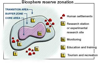
Biosphere Reserve Zonation

Biosphere reserves have a research-intensive core area or areas at their heart, surrounded by a buffer zone, where sustainable development is fostered, before gradually transitioning into the surrounding region. Many reserves have innovative systems of governance designed to ensure that the views of local people are fully respected. The idea of biosphere reserves was first proposed in 1968 at the UNESCO “Biosphere Conference”, the first international attempt to reconcile the need for conservation with the use of natural resources for development.

No system is perfect. The challenges for biosphere reserves include strengthening the worldwide network by establishing new reserves in areas where few currently exist, as well as helping meet the on-going funding needs for all the reserves. One of the most significant future threats to biosphere reserves is likely to be the habitat changes wrought by global warming.

One of the more startling surprises in the existing network of reserves is the almost total lack of protection afforded to such an amazing part of Mexico as the Copper Canyon region, with its indigenous Tarahumara people and world-class scenery. But perhaps one day this region, too, will become part of Mexico’s extensive system of protected areas.

Mexico’s Biosphere Reserves, as of July 2011:

Baja California Peninsula:

  • El Vizcaíno (Baja California Sur): desert, mountain and coastal/marine ecosystems, petroglyphs, wall paintings, birds and Grey whales.
  • Sierra La Laguna (Baja California Sur): contrasting ecosystems, woodlands and scrub, with high degree of endemism.
  • Alto Golfo de California (Baja California and Sonora): extraordinary geological formations with volcanic craters, dunes, oasis and beaches, and a diversity of plant associations.
  • Islas del Golfo de California (Baja California Sur and Sonora): series of over 240 islands with high number of endemic species; ornithological paradise.

Northern Mexico:

  • Mapimí (Durango, Chihuahua and Coahuila): fragile warm desert and semi-desert ecosystems.
  • La Michilía (Durango): mountainous area of pine-oak forest; habitat for the now rare black bear (Ursus americanus) and wolf (Canis lupus).
  • El Cielo (Tamaulipas): one of the most ecologically rich and diverse parts of Mexico; numerous endangered animal species; ecotourism area.
  • Laguna Madre and Río Bravo Delta (Tamaulipas): a migratory bird haven on coastal wetlands.
  • Cumbres de Monterrey (Nuevo León): the landmark mountains that ensure the water supply for the state capital.
  • Maderas del Carmen (Coahuila): encompassing parts of the Chihuahuan Desert in Coahuila state adjacent to the U.S. biosphere reserve of Big Bend National Park.
  • Cuatrociénegas (Coahuila): an oasis with 500 pools that preserve species found only in the Coahuila state part of the Chihuahua desert.
  • Sierra de Alamos–Rio Cuchujaqui (Sonora): endangered tropical deciduous forest.

Central and Western Mexico:

  • Sierra de Manantlán (Jalisco and Colima): transition of the Nearctic and Neotropical biological realms; cloud forest and wild perennial corn (Zea diploperennis).
  • Chamela-Cuixmala (Jalisco): a Pacific Coast dry tropical forest harboring iguanas and crocodiles in lagoons and marshes.
  • Islas Marietas (Nayarit): a biodiverse archipelago of islands with a rich mix of marine species, corals and landforms.
  • La Primavera (Jalisco): pine and oak forest in a caldera close to Guadalajara, Mexico’s second city.
  • Sierra Gorda (Querétaro): ecologically diverse area with 14 vegetation types, historic missions and Huastec Indians.
  • Monarch butterfly migration sites (Michoacán and State of México): unique annual migration links Mexico to Canada and the U.S.
  • Sierra de Huautla (Morelos): woods full of endemic species.
  • Barranca de Metztitlán (Hidalgo): home of Otomí Indians and large variety of wildlife.
  • Los Volcanes (State of México/Puebla) is the volcanic landscape of significant aesthetic and touristic value that surrounds the twin volcanoes of Popocatépetl and Ixtaccíhuatl.
  • Islas Marías (Nayarit), a group of four islands, perhaps best known for its federal penitentiary, with considerable diversity of ecosystems and many
    endemic species.

Eastern Mexico:

  • Los Tuxtlas (Veracruz): a beautiful jungle-covered volcanic region, with vestiges of pre-Hispanic archeology.
  • Sistema Arrecifal Veracruzano (Veracruz): an archipelago off the Caribbean coast.
  • Pantanos de Centla (Tabasco): villages in coastal wetlands.

Southern Mexico:

  • Montes Azules (Chiapas): Lacandon tropical rainforest; 500 species of trees; several indigenous groups (including Tzeltal, Chol and Lacandon Maya).
  • Volcán Tacana (Chiapas): fragile ecosystems in Chiapas, adjacent to Guatamala.
  • El Triunfo (Chiapas): diverse evergreen cloud forest in rugged mountain terrain; a primary Pleistocene refuge for numerous endemic plants and animals; large mobile population.
  • La Encrucijada (Chiapas): shrimping lagoons on the Pacific Coast.
  • La Sepultura (Chiapas): ancestral lands of the Olmec and other pre-Hispanic cultures.
  • Selva El Ocote (Chiapas): rain forests, caves and reserves of underground water.
  • Huatulco (Oaxaca): coastal reserve protecting endangered sea turtles, dolphins and purple snails.
  • Lagunas de Montebello (Chiapas) series of beautiful lakes close to the border with Guatemala, set in upland, wooded terrain, with varied flora and fauna including orchids, butterflies, fish, reptiles, mammals and birds.
  • Naha-Metzabok (Chiapas) northern section of the Lacandon tropical forest, home to several members of the cat family and an important part of the Mayan forest biological corridor

Yucatán Peninsula

  • Ría Celestún (Yucatán and Campeche): coastal region including important wetlands and drowned river valley (ría) with diverse fauna and flora, including flamingos.
  • Región de Calakmul (Yucatán): diverse tropical rainforests; the largest forest reserve in Mexico, with important Maya sites; ecotourism project.
  • Ría Lagartos (Yucatán): coastal estuary with diverse birdlife including more than 18000 pink flamingos as well as some 30,000 migratory birds.
  • Arrecife Alacranes (Yucatán): the largest coral reef in the Gulf of Mexico, and the only one in Yucatán state.
  • Sian Ka’an (Quintana Roo): coastal limestone plain, and extensive barrier reef system on Caribbean coast, with numerous archaeological sites; more than 4,000 plant species.
  • Banco Chinchorro (Quintana Roo): mosaic of open water, sea grass beds, mangroves, sandy beaches and coral reefs; more than 95 species of coral.

Main source: UNESCO: Directory of the World Network of Biosphere Reserves

Related posts:

Jul 182011
 

With so much media attention focused on drug violence in Mexico, many potential tourists and tour operators are canceling planned trips to Mexico. Are such decisions rational? The analysis below indicates that travel to Mexico is considerably safer than risking vehicle traffic in the USA.

The US State Department has issued numerous travel advisories concerning visits to Mexico. As we discussed in a previous post —Which parts of Mexico are currently subject to US travel advisories?— the advisories focus on specific areas of Mexico. Unfortunately, many potential tourists overlook the geographic specificity and get the impression that all parts of Mexico are dangerous. Previous posts clearly indicate that levels of drug war violence vary enormously from place to place in Mexico.

This post investigates the chances of being a fatal victim of drug violence in various places in Mexico and compares these with the chances of being a fatal victim of a traffic accident in the USA. The US Department of Commerce estimates that about 19 million US citizens visit Mexico each year. According to MSNBC, in 2010 at least 106 Americans were killed in Mexico as a result of drug violence. Dividing the 19 million visits by the 106 deaths suggests that the chance of a visitor being killed on a trip to Mexico in 2010 was about 1 in 179,000. These are good odds, much better than the annual chance of being killed in a US traffic accident which is about 9,000 to 1. In other words, the chances of dying in a US traffic accident are roughly 20 times greater than being killed as a consequence of drug violence while visiting  Mexico. (As an aside, the annual chances of being killed in a Mexican traffic accident are about 1 in 4,800.)

Chance of a visitor being killed in drug violence in MexicoRelative danger of death in a road accident in the USA
MEXICO (whole country)1 in 179,00020 times greater
Ciudad Juárez1 in 11,4001.3 times greater
State of Chihuahua1 in 18,5002.1 times greater
Culiacán1 in 25,0002.8 times greater
Mazatlán1 in 47,0005.2 times greater
Tijuana1 in 52,0005.7 times greater
Monterrey1 in 210,00023 times greater
Puerto Vallarta1 in 288,00032 times greater
Chapala1 in 299,00033 times greater
Cancún1 in 360,00040 times greater
State of Jalisco1 in 378,00042 times greater
Oaxaca City1 in 427,00048 times greater
Guadalajara1 in 569,00063 times greater
Mexico City1 in 750,00083 times greater
State of Yucatán1 in 4,151,000460 times greater
Puebla City1 in 6,572,000730 times greater

Some areas of Mexico experience much more drug violence than others. For example drug violence deaths in Ciudad Juárez are 16 times greater than the Mexico national average. Consequently, the chance of an American visitor getting killed in drug violence in Ciudad Juárez is about 11,400 to one, still safer than risking traffic in the USA. The table shows the risks for a range of Mexican locations and compares them to the risks of US traffic. In the city of Puebla the risk is one in 6.6 million compared to one in 750,000 for Mexico City, one in 570,000 for Guadalajara, one in 360,000 for Cancún, about one in 300,000 for Chapala and Puerto Vallarta, and about one in 50,000 for Tijuana and Mazatlán.

These results indicate that the chance of a visitor being killed by drug violence in Mexico is extremely unlikely, far less likely than the risk of being killed in a US traffic accident. For example, a visit to Chapala is 33 times safer than risking US traffic for a year, while Mexico City is 83 times safer. Though this analysis focuses on the travel of US tourists to Mexico, the results are equally relevant for visitors from other countries.

Exhibition of National Geographic images of Mexico at the Mexican Cultural Institute in Washington D.C.

 Other  Comments Off on Exhibition of National Geographic images of Mexico at the Mexican Cultural Institute in Washington D.C.
Jul 152011


If you’re visiting Washington D.C. this summer, don’t miss the exhibition entitled Mexico Through the Lens of National Geographic: celebrating a century of visual exploration, on at the Mexican Cultural Institute in Washington D.C. through October 22.

exhibition logoThe exhibition features more than 130 National Geographic images of Mexico taken from feature articles published in the magazine in the past 100 years. The images are arranged in seven groups: Explorers, The Maya, The 1916 and 1996 Special Issues on Mexico, Nature, The Border, People and The Photographic Eye.

Our attention was drawn to this exhibition by the always-interesting blog supporting National Geographic’s “My Wonderful World” Campaign. “My wonderful World” is an initiative to expand geographic learning in school, at home, and in communities—just the kind of initiative that we at Geo-Mexico.com wholeheartedly support.

Many people have great memories of particular National Geographic photos or articles that made an impact on their lives. In my case, by a happy coincidence, it is one of the images included in the “My Wonderful World” post about the exhibition: an image of Monarch butterflies that was included in the cover article of the August 1976 issue. This photo would change my life, though I didn’t know it at the time!

The Mexican Cultural Institute is located at 2829 16th Street, NW Washington DC 20009.  Gallery Hours are Monday–Friday from 10:00am to 6:00pm and Saturday from 12:00 – 4:00pm.  Enjoy!

Jul 112011
 

Many Chicano activists refer to Mexicans as “La Raza”, literally “the race”. “Dia de la Raza” is celebrated on Columbus Day (October 12) as the day the Mexican indigenous population started their resistance against the European invasion.

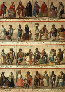
Racial classification in colonial times

Racial classification in colonial times (Click to enlarge)

The term “La Raza” derives from a 1948 book “La Raza Cósmica.” The author Jose Vasconcelos’ thesis is that Mexicans (who he defines as a combination of indigenous and European bloodlines) are a new superior race. In developing his thesis, Vasconcelos draws upon many concepts including Marxism; he felt Europeans were too materialistic and capitalistic. He suggested that Mexicans have evolved (à la Darwin) into a new race that would be a world leader in the years ahead. The Government of Mexico tacitly agreed with this approach which engendered national pride. It was also consistent with the government’s post Mexican Revolution view that all ethnic groups should be combined into a common Mexican national identity.

According to the 2010 census, about 15% consider themselves indigenous, though about 58% of these do not speak any indigenous language. Assuming the “white” and “other” categories are still about 10% and 2% respectively, this suggests that today about 73% are mestizos. Almost all people in Mexico refer to themselves simply as “Mexicans”, not as indigenous Mexicans or mestizos or whites.

Vasconcelos’ “Raza Cósmica” and most Mexicans overlook the historical fact that Mexicans have an important African heritage. Between 100,000 to 200,000 African slaves were brought into Mexico during the 16th through 18th centuries, nearly a quarter the number brought to the USA. In 1646 there were 35,000 African slaves in Mexico, more than 2.5 times the white population [see Blacks outnumbered Spaniards in Mexico until after 1810]. These slaves represented about 12% of the total population, roughly equal to the percentage of slaves in the USA before 1860.

Mexico’s second president, Vicente Guerrero, whose mother was partially Black, abolished slavery in 1829. Thousands of Blacks moved into Mexico from the USA before it abolished slavery in 1865. However, today there are very very few black faces in Mexico. One can spend weeks in Mexico’s major cities without seeing a Black Mexican. If one pays close attention, they can identify people of African heritage in a few selected communities in Veracruz and along the Costa Chica in Guerrero and Oaxaca [Bobby Vaughn’s homepage: Afro-Mexicans of Costa Chica ].

What happened to all the Blacks in Mexico?  [Blacks in Mexico] In a word they assimilated by having offspring with other racial groups. In colonial times, the Catholic Church went to great lengths to categorize intermixed races for marital and baptism purposes:

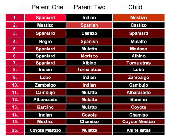
The terminology for racial mixes

Complex terminology for racial mixes

Before too long, nobody could keep all the combinations straight! Eventually, everyone of mixed race was considered a mestizo. The African portion was purposely or accidentally dropped.

Modern research, based on DNA, indicates that Mexican mestizos are genetically about one-eighth African [mtDNA Affinities of the Peoples of North-Central Mexico]. While Brazil is often identified as the world’s foremost melting pot, the evidence suggests that in Mexico the races have melted more than in any other country.

While there are very few black faces in Mexico, there is a great deal of African heritage represented in art, music, dance, food, and even in fishing and agricultural practices. Did you know that the popular Mexican song “La Bamba” recorded by Richie Valens, Los Lobos and others can be traced back to the Bamba district of Angola? As part of the 500th anniversary of Columbus’ famous voyage, the Government of Mexico finally acknowledged officially that Africa was Mexico’s “Third Root”.

Jun 252011
 

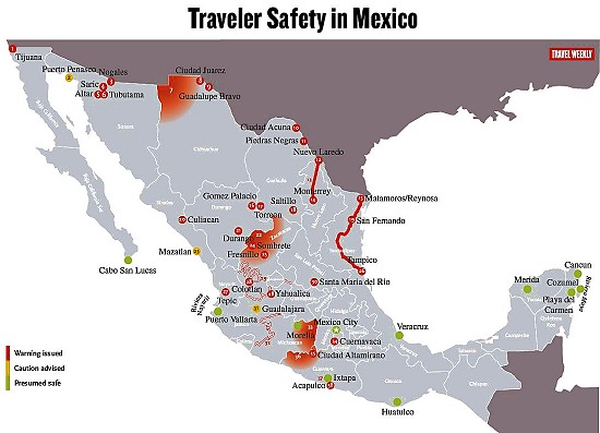
Over the past year, the US State Department has issued repeated warnings about travel in Mexico. Some of these warnings are specific to certain stretches of highway; others are broader and focus on cities or regions.

Travel Weekly has produced a handy map showing the areas currently affected by advisories (a version of this map appears below). Resorts colored green are “presumed to be safe”, while yellow means “caution” and red means “warning issued”.

  • Link to the Travel Weekly pdf map with full details, explaining the significance of each numbered location,
Traveler Safety in Mexico. Map Credit: Travel Weekly – www.travelweekly.com/mexicomap/

Note that “Sombrete” on the map, near Fresnillo, should actually be Sombrerete. (Curiously, this is the exactly same mistake made recently by the Victoria and Albert Museum in London in the text accompanying a display about silver in Latin America. Sombrerete was a very important silver-mining center during colonial times, and the town is well worth visiting, advisories permitting, for numerous fine colonial buildings).

Given the map, it is perhaps not really a great surprise that Mexico’s federal Tourism Department is currently actively promoting the Caribbean coast and “Mundo Maya” (Maya World), a region well removed from the red-colored zones on the map.

According to a slew of articles in Mexico’s Spanish-language press:

Mexico’s role in the birth control revolution

 Other  Comments Off on Mexico’s role in the birth control revolution
Jun 212011
 

The oral contraceptive pill, often referred to simply as “the Pill” will be officially sixty years old on October 15, 2011. In the words of The Economist: it “was arguably the first lifestyle drug to control a normal bodily function—fertility—rather than a dread disorder. It transformed the lives of millions and helped reshape the role of medicine in reproduction.” Its social impact was massive, helping to foment the sexual and feminist revolutions.

From a geographic perspective, the Pill coincided with ever-increasing concern about the rate of world population growth, and its impact on resources –  the start of an era which led to such seminal works as The Population Bomb and The Limits of Growth.

Initially, the development of the Pill was met by medical, religious and social furor, much of which has since subsided. Even though its popularity has declined since the 1960s, because of concerns about possible side effects, it is estimated that it is still used, in one form or another, by more than 80 million women worldwide.

Curiously, the synthetic female sex hormone called norethindrone was first synthesized from, believe it or not… Mexican-grown yams!

Equally interestingly, the Pill was not developed in a huge laboratory belonging to a major pharmaceutical company but in a relatively humble laboratory in Mexico City, belonging to a small company called Syntex. Syntex specialized in making steroids from Mexican yams, using methods of synthesis invented by a maverick biochemist, Russell Marker. Marker had published various studies on diosgenin, a saponin isolated from a Mexican yam species of the genus Dioscorea, and had discovered how to synthesize the human hormone testosterone and progesterone from diosgenin. After having his proposals for the large-scale production of human steroids from diosgenin turned down by U.S. pharmaceutical companies, Marker moved to Mexico and began his own, home-based, small scale production. This was so successful that a new company, Syntex, was soon born, specifically to make steroids from Mexican yams. Syntex quickly became the world’s largest producer of progesterone, as well as making testosterone and the female hormone esterone.

Enter Carl Djerassi. Djerassi was an Austrian-born chemist who had completed his PhD at the University of Wisconsin (1945) by researching the synthesis and transformation of steroids, including sex hormones. After working four years as a research chemist with CIBA Pharmaceutical Co. in Summit, New Jersey, he decided on a strategic move, in 1949, to join Syntex, in Mexico City, as associate director of chemical research.

At Syntex, Djerassi set out to see if diosgenin could be made to yield other steroids, which do not actually exist in nature, but which retain the biological activities of progesterone and are also orally active. The original aim of his team was to develop a drug for infertility and menstrual disorders that could be swallowed, as opposed to injected. Only two years later, on October 15, 1951, the group led by the then 28-year-old Djerassi, had synthesized norethindrone, a “super-potent orally active progestational agent”, which turned out to be the key ingredient in The Pill. (Chemically, norethindrone is 17a-ethinyl-19-nortestosterone; its generic name in Europe is norethisterone).

Later, the drug’s ability to suppress ovulation was demonstrated by Gregory Pingus at the Worcester Foundation in Massachusetts and clinical trials began. The rest, as they say, is history!

Djerassi is Emeritus Professor of Chemistry at Stanford University with an extremely distinguished scientific record, holding no fewer than 19 honorary doctorates in addition to numerous other honors. He is also one of only a handful of American scientists to have been awarded both the National Medal of Science (1973, for the first synthesis of a steroid contraceptive, The Pill) and the National Medal of Technology (1991, for promoting new approaches to insect control).

In medicinal chemistry he will be forever associated with the initial developments in the fields of oral contraceptives (Norethindrone), antihistamines (Pyribenzamine) and topical corticosteroids (Synalar).

They say that the well-rounded man combines scientific inquiry with artistic appreciation, and Djerassi is certainly no exception, having turned, in later life, to science fiction writing, examining the human side of scientists and the personal conflicts they face in their quest for knowledge, personal recognition, and financial rewards. One of his plays, “An Immaculate Misconception,” premiered in 1998 at the Edinburgh Fringe Festival and has since been performed in London, San Francisco, Sweden, Vienna and Cologne. It was also broadcast on BBC World Service Radio in May 2000.

Sources:

The idea for this post originated from a review in The Economist (October 13, 2001) of two books: Sexual Chemistry: A History of the Contraceptive Pill (Lara Marks, Yale) and This Man’s Pill. Reflections on the 50th Birthday of the Pill. (Carl Djerassi, Oxford University Press).

Several chapters of Geo-Mexico: the geography and dynamics of modern Mexico discuss Mexico’s population dynamics and trends, and their implications for future development. An earlier post here links to a pdf file showing Mexico’s population pyramid in 1990, and the predicted pyramid for 2050.

Why Las Tuxtlas Biosphere Reserve is well worth a visit

 Other  Comments Off on Why Las Tuxtlas Biosphere Reserve is well worth a visit
Jun 132011
 

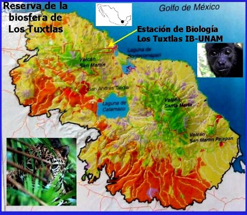
In a recent post, we looked at an Enchanted Lake in southern Mexico, in the Sierra de las Tuxtlas, near Catemaco in the Gulf Coast state of Veracruz. In this post we take a look at the surrounding Las Tuxtlas Biosphere Reserve.

Tuxtlas biosphere reserve

Scenically, the entire Tuxtlas region is one of the most fabulously beautiful in all of Mexico. High temperatures combined with lots of rainfall result in luxuriant vegetation and boundless wildlife. Average monthly temperatures range from a pleasant 21 degrees C (70 degrees F) in January to a high of 28 degrees C (82 degrees F) in May, just before the rainy season kicks in. During the rainy season, from June to October, some 2000 mm (79 inches) of rain falls, often in late afternoon tropical deluges.

The jungle masking the lower slopes of the San Martín volcano gradually merges into tropical cloud forest at higher altitudes. Competing with the Silk Cotton (Kapok) and Ficus trees for light and sustenance are ground-hugging ferns. Overhead, the tangle of tree branches provides support for thousands of non-parasitic bromeliads (“air” plants) and orchids. More than 1300 species of flowering plants have been identified in this classic area for Neotropical ecology.

Bird-watchers are likely to spot the spectacular Keel-billed Toucan, or hear a Tody Motmot. Smaller birds include several species of hummingbird; look for the endemic Long-tailed Sabrewing. About half of all the bird species recorded in Mexico have been seen here, but birds are not the only wild animals inhabiting the jungle. Ocelots and tapirs are regularly seen and you may be lucky enough to see spider monkeys playing overhead in the canopy.

Clearance of the land for grazing and cultivation of the slopes to grow tobacco, bananas and sugar cane have reduced the original jungle to a relatively small number of isolated fragments. Fortuitously, this provides more varied habitats than the original vegetation, helping to enrich the area’s wildlife, further enhancing the region’s reputation as an ornithological and botanical paradise.

Fortunately an extensive area of this region was declared a Biosphere Reserve in 1998, ensuring that conservation programs now go hand-in-hand with human activities. The total area forming the Reserva de la Biósfera “Los Tuxtlas” is 155,122 hectares (380,000 acres).

Chapter 5 of Geo-Mexico: the geography and dynamics of modern Mexico focuses on Mexico’s ecosystems and biodiversity.  Chapter 30 analyzes environmental issues and trends including current environmental threats and efforts to protect the environment.  Buy your copy today to have a handy reference guide to all major aspects of Mexico’s geography!

How did Mexico get to be the world’s 11th most populous country?

 Other  Comments Off on How did Mexico get to be the world’s 11th most populous country?
Jun 112011
 

Mexico is currently the world’s 11th most populous country. While it has not always held this position, Mexico has been among the world’s population leaders for the last two thousand years. Worldmapper.org provides data on the estimated population occupying the areas of current countries for various years starting in the year one, when India (62 million) and China (60 million) had more than half of world’s total population of 231 million. No other country had more than eight million. Mexico ranked 17th with an estimated two million inhabitants. According to available data eight countries have always been more populous than Mexico: China, India, Bangladesh, Russia, Pakistan, Japan and Indonesia.

The next data point is the year 1500, when Mexico ranked 13th with an estimated population of seven million. This estimate seems reasonable, though some feel that Mexico’s population might have been as large as 15 million which would have made Mexico the third most populous country on the planet behind only China and India. Between year 1 and 1500, Mexico surpassed Turkey, Spain, Egypt, Iran, and the Ukraine; but was passed by Germany.

Mexico’s total population plunged after the Spanish arrived bringing small pox, other diseases and major social disruption. By 1600, Mexico’s population was down to 2.5 million, but it was still the most populous country in the New World, according to data provided by gapminder.org. It ranked 22nd tied with Austria and behind such countries as Czechoslovakia, Poland, Sudan, and Yugoslavia.

In 1700 Mexico’s population was 4.5 million, ranking it 18th. By 1820 the USA had moved past Mexico’s population of 6.6 million to become the most populous country in the New World. Mexico maintained its 19th ranking until 1870 when Brazil surpassed Mexico’s population of 9.2 million to become the most populous country in Latin America. It is interesting that there were relatively few changes in the ranks of the top 20 countries during the 170 year period between 1700 and 1870, except for the USA which went from 40th to 4th.

Since 1870 Mexico’s population has surpassed that of nine different European countries. By 1900 Mexico had 11.7 million inhabitants moving it past Czechoslovakia and Turkey into the 18th spot. (Note that Gapminder population figures are higher than the Mexican census figures, perhaps because they attempted to correct for census under-counting; for the purposes of this analysis we use the Gapminder figures.) Mexico maintained its 18th rank until 1950 when its population of 28.5 million edged it past Spain and war torn Poland into 16th place. In 1970 its population reached 52.8 million putting Mexico in 14th place ahead of France and the Ukraine. By 1980 Mexico’s population of 68.3 million pushed it past Italy and Britain into 12th place. A decade later its population of 84.9 million moved Mexico past Germany into the 11th spot, where it has remained.

What will happen in future decades? Mexico’s position will change, but only slightly. In 2020, Mexico’s population may reach 125 million moving it past Japan into 10th place (Population forecasts for 2020 to 2050 are from the U.S. Bureau of Census). By 2030, Mexico, with a population of about 135 million, will have passed Russia, but fallen behind Ethiopia and the Philippines, putting it back in the 11th spot.

Mexico’s estimated population of 144 million in 2050 will place it 12th behind the Congo (World Population Prospects: the 2010 Revision). According to the United Nations, by 2100 Mexico’s population will decrease to 127 million moving it to the 20th spot, behind Tanzania, Uganda, Kenya, Iraq, Zambia, Niger, Malawi, and Sudan. Obviously, the accuracy of such a long term forecasts is very speculative. For example, given global climate change and possible food scarcities, some doubt if the sub-Saharan African countries can grow as rapidly during the last half of the 21st century as projected by the United Nations.

Jun 102011
 

‘War is God’s way of teaching Americans geography.”

This quote is commonly attributed to Ambrose Bierce, the American journalist and satirist, who fell off the map in Revolutionary Mexico in 1913, never to be seen again. However, as pointed out by an alert reader (see comments), the quote has never been established as originating with Bierce and may well derive from “War was God’s way of teaching us geography”, a line delivered by comedian Paul Rodriguez in 1987 (quoted in the LA Times).

To ensure that this post has a link to Mexico, In The Devil’s Dictionary, Bierce defined Boundary:

BOUNDARY, n. “In political geography, an imaginary line between two nations, separating the imaginary rights of one from the imaginary rights of the other.”

The changing political frontiers of Mexico are the subject of chapter 12 of Geo-Mexico: the geography and dynamics of modern Mexico, your handy reference guide to all aspects of Mexico’s geography. Ask your local library to buy a copy TODAY! Also available from amazon.com

Jun 092011
 

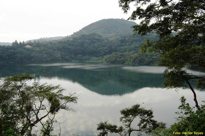
Peculiar, but true. There are several lakes named Laguna Encantada (Enchanted Lake) in Mexico, but this one is near Catemaco in the Tuxtlas region of the state of Veracruz. Catemaco is famous for its witches, so perhaps one of them cast a spell on the lake, making it behave perversely, its level changing in opposition to all the other lakes in the country?

Laguna Encantada

Laguna Encantada, Veracruz. Photo credit: Hector Reyes

Occupying the crater of an extinct volcano, La Laguna Encantada is a truly beautiful lake, especially near sunrise or sunset. Laguna Encantada is located 3 km northeast of San Andrés Tuxtla. The access road is unpaved. The views are ever-changing on the easy walk of about 1500 meters (slightly under one mile) around its shoreline. As you walk, try counting the butterflies. A study twenty years ago recorded a staggering total of 182 different species in this relatively small area of jungle.

The lake nestles on the southern flank of the San Martín volcano. This dormant volcano is a prominent landmark north-west of Lake Catemaco close to San Andrés Tuxtla. Its crater, 1500 meters across, is at a height of about 1400 meters above sea level, and has two small subsidiary cones inside it.

The basaltic lavas and layers of ash forming the volcano are highly permeable and porous. As a result, despite the heavy rainfall, there are no permanent streams flowing down the upper slopes.

Some distance away from the volcano, though, there are several good-sized lakes including Catemaco and Laguna Encantada. Catemaco is large enough to capture plenty of rainfall to maintain its level. The much smaller basin holding Laguna Encantada (350 meters above sea level), however, does not receive sufficient rain to keep its level high.

Instead, and this is the wonder of La Laguna Encantada, much of its water supply comes from underground. Water that falls on the slopes of the San Martín volcano during the rainy season soaks into the ground and then percolates slowly towards the lake, so slowly that it takes six months to reach it. The result? The lake is unable to sustain its level during the rainy season, but the underground water reaching it in the dry season is more than sufficient to replenish its level. Maybe the witches of Catemaco have something to do with it, but hydrology also plays a part!

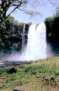
Eyipantla Falls

Eyipantla Falls Photo: Tony Burton

Salto de Eyipantla

Only a few kilometers from Laguna Encantada is another wonderful natural sight: the Eyipantla Waterfall (Salto de Eyipantla). The water for the falls comes from the Comoapan river, which drains Lake Catemaco. After heavy rain, the curtain of water at Eyipantla is about 50 meters high and 20 meters wide. The sunlight playing on the water creates a dazzling display of magical colors. The Tuxtlas region has been the setting for numerous movies and commercials and the impressive Eyipantla Falls have starred in many of them. The unusual name, Eyipantla, reflects its three chutes of water, and is derived from the Nahuátl words, eyi (three), pantli (trench) and tla (water).

Chapter 4 of Geo-Mexico: the geography and dynamics of modern Mexico discusses Mexico’s diverse climates.  Chapter 5 focuses on ecosystems and biodiversity.  Chapter 30 analyzes environmental issues and trends including the impact of Old World species imported by the Spaniards, current environmental threats, and efforts to protect the environment.  Buy your copy today to have a handy reference guide to all major aspects of Mexico’s geography!

How were the Piedras Encimadas (Stacked Rocks) in Puebla, Mexico, formed?

 Other  Comments Off on How were the Piedras Encimadas (Stacked Rocks) in Puebla, Mexico, formed?
Jun 072011
 

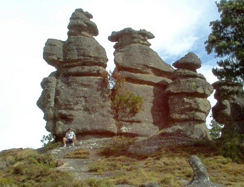
The Valle de las Piedras Encimadas (Valley of the Stacked Rocks) is 150 km from the city of Puebla in the northern part of the eponymous state. The Piedras Encimadas are rock outcrops occupying an area of about 4 square km (990 acres) centered on a small valley at an altitude of 2400 meters above sea level. The dominant natural vegetation is pine-oak forest. The main natural attraction of the area are the numerous, fascinating and photogenic”stacked rock” formations.

Piedras Encimadas, Zacatlán
Piedras Encimadas, Zacatlán, Sierra Norte, Puebla

The stacked rocks of the Piedras Encimadas can easily be likened to people (soldiers, sentries) and animals (dinosaurs, elephants, turtles), depending on the sensibilities of the observer. The shapes appear even more “fantastic” on the frequent occasions when clouds roll into the valley, enveloping the rocks in a thin mist.

According to geography researchers from the National University (UNAM), the volcanic rocks (rhyolites and andesites) forming the Piedras Encimadas date from the Tertiary period (60 million years BP).

The Piedras Encimadas look very similar to the much-studied granite “tors” found in the UK and elsewhere. Indeed, they may even have been formed in a similar way. However, geologists still debate precisely how tors were formed, and their uncertainties almost certainly apply equally to the Piedras Encimadas.

  • Theories for the formation of tors on Dartmoor, UK

Most theories of tor formation (see link)  involve the concept of “differential weathering”. This occurs when some parts of an area weather (disintegrate) more rapidly than others. Differences in weathering rates result from a variety of reasons, including differences in rock types and resistance within the same rock type, as well as localized changes in the climate, vegetation cover, aspect (direction the slope faces), altitude or exposure to air or water.

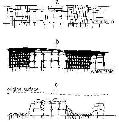
Tor formation (after Linton).
Tor formation (after Linton). Fig 3.5 of B.W. Sparks: Rocks and Relief (1971)

Over a long period of time, the weaker parts of the rock may have been weathered to greater depths than the more resistant parts. If subsequent erosion, most likely by river action in the context of Puebla, stripped away all the weathered rock, it would leave the more resistant rock as upstanding craggy outcrops (see sequence diagram above)

The shape of many of the blocks of rock forming the Piedras Encimadas does suggest that they were originally weathered deep underground from chemical reactions they underwent as water percolated slowly down towards the water table. Such a process would have acted more on the upper faces of each block, rather than the lower faces, producing a block that was rounded above, and almost flat below.

If the blocks had been modified by erosion (the other major possible interpretation), then it is more likely that both the upper and lower faces of each block would be equally rounded or that the lower face would be more eroded than the upper face.

Regardless of the details, it is almost certain that the curiously-shaped Piedras Encimadas were formed by a combination of volcanic action, differential weathering and erosion. The Piedras Encimadas offer lots of interesting possibilities for geography fieldwork.

Related posts:

Jun 062011
 

Mexico’s aerospace sector attracted $1.25 billion in investments in 2010, 25% more than in 2009. The city of Querétaro has become the hub of Mexico’s fledgling aerospace sector, with several companies choosing it as an ideal manufacturing location. Opening a new section of the Bombardier plant in the city of Quéretaro, President Felipe Calderón highlighted the sector’s rapid growth in Mexico; the 200 firms in the sector currently provide 30,000 jobs. The federal government believes that Mexico can become a producer of planes for international markets within the next 5 to 10 years.

Canada-based Bombardier supplies 38% of the world’s business airplane market, and predicts a significant growth in the sector over the next few years. The Bombardier plant in Querétaro will make the fuselage and electrical systems for the new Learjet 85 business aircraft. Bombardier has committed $450 million over the next seven years to expand the plant.

Another firm starting production in Querétaro is Eurocopter, a leading manufacturer of helicopters. It is investing $550 million to build a factory to make components for the aeronautical industry, primarily for export. The components include door structures and tail sections for Airbus and other planes.

A third major company, General Electric, the US-based multinational, has opened its own new advanced engineering center in the city of Querétaro. The $20 million, 8,000-square-meter center is part of a facility making parts for the Airbus 380 airliner. It will specialize in research and design of airplane turbines and power systems. The center, the only one of its kind in Latin America, will employ more than 1,300 highly qualified engineers. It is General Electric’s largest engineering center outside the USA.

Supporting the growth in aerospace industries is Querétaro International Airport, which has drastically reduced its non-renewable energy consumption (and energy costs) by becoming almost totally self-sufficient, relying on solar power. The airport’s solar panels have an installed capacity of 924KW, allowing the airport to profit from feeding surplus electricity back into Mexico’s national electricity grid.

Why has Querétaro become the center of Mexico’s fledgling aeronautical industry?

  • City is centrally located with excellent transport links via highways and railways to both coasts and to several US border crossings.
  • It is relatively close to Mexico City, the seat of political power and location of almost all federal offices
  • It has a large, well-educated, easily trained and skilled workforce
  • The city currently has fewer security concerns than possible rivals such as Monterrey in Nuevo León.
  • Mexico has a highly competitive business environment with numerous major international manufacturing facilities for other kinds of vehicles.

The changes reflect the trend in Mexico’s manufacturing sector away from high volume, low-cost manufacturing processes towards higher value, high tech industries.

Relying on geography for orientation: some indigenous languages do not have words for “left” or “right”

 Other  Comments Off on Relying on geography for orientation: some indigenous languages do not have words for “left” or “right”
May 242011
 

Mexico’s indigenous groups have long been a rich resource for investigations of all manner of research concerning culture, linguistics and sociology.

In this post, we consider Spatial Reasoning Skills in Tenejapan Mayans, a study relating to geographic reasoning, which relied on the participation of indigenous Tseltal-speaking Maya in Tenejapa (Chiapas), southern Mexico.

According to the inter-census population count in 2005, Tseltal (aka Tzeltal) is spoken by 371,730 individuals over the age of 5, making it Mexico’s fifth most-spoken indigenous language (after Náhautl, Maya or Yucatec Maya, Mixtec and Zapotec). More than 25% of Tseltal speakers are monolingual and do not speak Spanish. They reside in several municipalities of Chiapas, including Ocosingo, Altamirano, Tenejapa, Chanal, Sitalá, Amatenango del Valle, San Cristóbal de las Casas and Oxchuc.

Peggy Li, Linda Abarbanell and Anna Papafragou, the authors of the study, examined the “possible influences of language on thought in the domain of spatial reasoning.”

They distinguished between egocentric orientation and geocentric orientation:

“Language communities differ in their stock of reference frames (coordinate systems to reference locations and directions). English typically uses egocentrically-defined axes (“left-right”). Other languages like Tseltal lack such a system but use geocentrically-defined axes (“north-south”).”

They then compared how a group of Tseltal speakers tackled simple orientation tasks that required egocentric spatial reasoning skills. Their expectation was that Tseltal speakers would be poor at these tasks compared to a control group of Tseltal speakers who also spoke Spanish (which has many egocentric words).

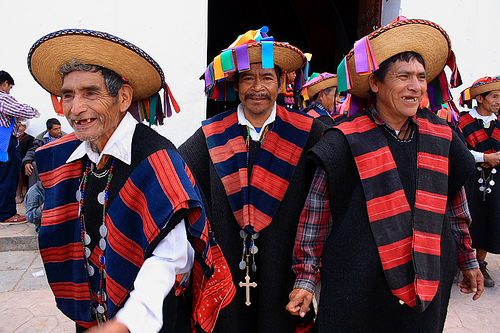
Tzeltal elders
Tzeltal elders – looking right or left? Credit: Enrique Escalona, México D.F.

The expectation was that Tenejapans would find egocentric reasoning much harder than geocentric spatial reasoning since their language has no egocentric vocabulary for anything beyond their own bodies. [Tseltal “does have two “body part words “xin” (left) and “wa’el” (right)”, though they are never used for anything outside the body.] This expectation was based in part on an earlier anecdotal report that “a Tenejapan blindfolded and spun around 20 times in a darkened house was able to point in the agreed [compass] direction while still dizzy and blindfolded”.

To some people’s surprise, the Tseltal speakers were able to solve tasks requiring egocentric skills at a rate far higher than mere chance would suggest, and indeed with a higher success rate than tasks requiring geocentric skills. The researcher concluded that tasks requiring egocentric spatial orientation skills are actually easier than those requiring geocentric spatial orientation, and that the absence of “left/right” in a language does not necessarily translate into any conceptual gap.

If Tseltal speakers don’t use “left and right” to locate objects, how do they describe where things are?

“In place of egocentric coordinates, Tenejapans and other Tseltal speakers utilize a system of terms (“alan” and “ajk’ol”) based on the overall inclination of the terrain (“downhill” and “uphill”) which they inhabit. These geocentrically-defined terms are extended and used even when one is on flat terrain to reference the general directions of uphill and downhill which roughly correspond to the north-south axis. Moreover, they are used in descriptions of small scale arrays such as the arrangement of items on tabletops for which English speakers prefer “left” and “right.” ”

We hope the Tenejapans (each received 50 pesos for participating) did not give all their secrets away at once, but have saved some for the enlightenment of future researchers…

Li, P., Abarbanell, L.,& Papafragou, A. (2005). Spatial reasoning skills in Tenejapan Mayans. Proceedings from the 27th Annual Meeting of the Cognitive Science Society. Hillsdale, NJ: Erlbaum.

Mexico’s Magic Towns now include Zacatlán in the Sierra Norte of Puebla

 Other  Comments Off on Mexico’s Magic Towns now include Zacatlán in the Sierra Norte of Puebla
May 192011
 

One of the Mexican Tourism Secretariat’s flagship programs is its “Magic Town” designation. This is a program that was long overdue when it finally began in 2001. Mexico’s Magic Towns (Pueblos Mágicos) range from tiny, almost undiscovered villages on the coast to sizable inland cities. What they all have in common is that they have some truly special cultural, historic or social importance.

Almost every state has at least one Magic Town; there are currently 41 scattered across the Republic,  with a further 70 seeking accreditation.

Towns accepted into the program have access to federal funds for publicity and improvements. For example, some of the towns have already relocated all those ugly wires, that despoil so many Mexican towns, safely underground, well out of sight. In all cases, a local committee oversees the projects, ensuring that local interests are always to the fore.

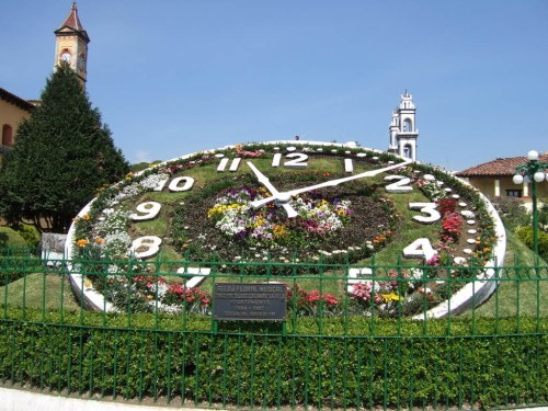
Musical floral clock in Zacatlán

One of the latest additions to the list of “Magic Towns” is Zacatlán in the Sierra Norte of the state of Puebla. This town, often called Zacatlán de las Manzanas (Zacatlán of the Apples) is a regional, commercial center in highland orchard country.The town (altitude: 2000 meters or 6700 feet; 2010 population: 76,296 )  is perched on a ledge overlooking the River Laxaxalpa. It celebrates an annual Apple Fair in early August.

Zacatlán’s attractions for tourism include:

  • close proximity to stunning natural landscape, including the fascinating and photogenic tor-like rock formations known as Piedras Encimadas (Stacked Rocks)
  • history and architecture: Several historic buildings including a Franciscan Friary dating back to the 16th century
  • a manufacturer of ornamental clocks (including Zacatlán’s own unusual musical floral clock)
  • local cuisine which includes tacos de barbacoa, pan relleno de requesón, fruit wines and mole
  • handicrafts, especially earthenware and woolen items

All in all, a worthy addition to the list of Magic Towns!

Many aspects of tourism, including the concepts associated with sustainable tourism, are analyzed in detail in chapter 19 of Geo-Mexico: the geography and dynamics of modern Mexico.

Our top 10 list of “googled” phrases which led to Geo-Mexico.com

 Other  Comments Off on Our top 10 list of “googled” phrases which led to Geo-Mexico.com
May 072011
 

Our trusty server stats include these “top ten” search phrases. Each of them (when entered into a certain famous leading search engine) magically brought one or more viewers to Geo-Mexico.com:

  • 10- parangaricutiro tongue twister – our post Geographic tongue-twister relating to a volcano explains this tricky-to-pronounce search
  • 9- what kind of aztec indian would you have been if u lived in El Salto mexico – perhaps an Aztec Indian?? Or, given the qualifier of “El Salto”, possibly a leaping Aztec Indian? [salto = jump or waterfall]
  • 8- what are the five countries in Mexico – We acknowledge that Mexico has suffered national identity crises various times in its tumultuous history, but fortunately never quite to this extent!
  • 7- are canada and Mexico equally linguistically diverse -Even counting the languages spoken by the various “First Nations” groups (as Canadians call their native peoples), Mexico wins this one easily. Some 60+ languages (not dialects) are spoken in Mexico
  • 6- what kind of cars do mexican cartels drive – hmm…hopefully, NOT the car you were driving just before they stopped you at a fake roadblock and took your set of wheels! [Unfortunately, this tactic has been used by drug cartels all too frequently in the past couple of years.]
  • 5- non churches in the 1600s – this intriguing concept needs narrowing down slightly before we can venture a more detailed response
  • 4- mexican cartel 1911 – possibly this was meant to be 2011 not 1911. However, Pancho Villa would indeed have been a powerful cartel leader, given half the chance; his cross-border excursions would have been very useful in that line of work, though his preferred method (horseback) was nowhere near as imaginative as the tunnels, catapults, aircraft and mini-subs used by cartels in 2011
  • 3- geographical routes from mexico to US – beyond the obvious road, railway and airline routes, we think “Geo-Mexico, the geography and dynamics of modern Mexico” has this well covered, since our chapters are clearly linked to the four major traditions of geography in the USA, and the five themes identified by the Association of American Geographers and the National Council for Geographic Education in 1984 for the teaching of geography – click the link to buy your copy today!
  • 2- names of all the volcanoes in mexico – definitely a challenging request. Assuming all categories—active, dormant and extinct—are included, the number must certainly run well into the hundreds
  • 1- spanish speaking states in mexico map – The answer to this, or the parallel question of “How many English-speaking states are there in the USA?”, might not be as obvious as it appears. However, to clear up any possible confusion, click HERE for our map of Spanish-speaking states in Mexico, and HERE for a fascinating, interactive map showing the distribution of Spanish-speakers (and other languages) in the USA. Zoom in for detailed views of individual states.

Our previous “Top Ten” list:

The Battle of Puebla is re-enacted each year on Cinco de Mayo (May 5), but in Mexico City

 Other  Comments Off on The Battle of Puebla is re-enacted each year on Cinco de Mayo (May 5), but in Mexico City
May 052011
 

The Mexican holiday of Cinco de Mayo (5 May) commemorates the Battle of Puebla, fought on May 5, 1862. Puebla is a major city about 100km east of Mexico City, on the historically important route to the port of Veracruz.

In 2012, to mark the 150th Anniversary of the Battle of Puebla, a major re-enactment of the Battle was held in Puebla, attended by the President and many cabinet members and officials. A commemorative bi-metallic 10-peso coin was also issued to commemorate this anniversary.

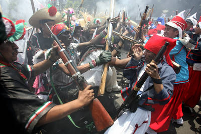
Since the 1930s, a re-enactment of the Battle of Puebla has been held each year at Peñón de los Baños, a rocky outcrop close to Mexico City’s international airport. Of geographical and geological interest, the rocky outcrop of Peñón de los Baños was formerly an island in the middle of Lake Texcoco. The prominent landmark was visited by Alexander von Humboldt when he toured parts of Mexico in 1803-4. Among other things, Humboldt analyzed the chemical composition of its thermal springs, thought to have curative and medicinal properties.

The re-enactment of the Battle of Puebla at Peñón de los Baños attracts tourists, history buffs, and Mexico City residents looking for an unusual experience.

Re-enactment of Battle of Puebla.

Re-enactment of Battle of Puebla. Photo credit: Jose Carlo González (La Jornada)

In an earlier post, we noted that the Cinco de Mayo holiday is less celebrated in Mexico these days than in the USA:

Celebrations of 5 May in the USA date back to the third quarter of the nineteenth century (only a few years after the Battle in 1862), though they gained prominence only after the 1950s and 60s when major Mexican beer makers associated their brands with Cinco de Mayo celebrations north of the border.

Mexican beer may be one of the country’s most important exports but, as the annual re-enactment in Peñón de los Baños shows,  the commemorations of Cinco de Mayo still held on Mexican soil are far more authentic.

May 032011
 

Somewhat surprisingly, the number of Mexicans speaking indigenous languages has increased significantly in the past 20 years. In 2010 there were 6.7 million indigenous speakers over age five compared to 6.0 million in 2000 and 5.3 million in 1990.

There are two factors contributing to this finding:

  • First, indigenous speakers are teaching their children to speak their indigenous language.
  • Second, indigenous speakers have higher than average birth rates.

The number of indigenous speakers that cannot speak Spanish decreased slightly from 1.0 million in 2000 to 981,000 in 2010.

The most widely spoken indigenous languages are:

  • Nahuatl, with 1,587,884 million speakers, followed by
  • Maya (796,405),
  • Mixteca (494,454),
  • Tzeltal (474,298).
  • Zapotec (460,683), and
  • Tzotzil (429,168).

[Note: language names used here include all minor variants of the particular language]

About 62% of all indigenous language speakers live in rural areas, communities with under 2,500 inhabitants. Nearly 20% live in small towns between 2,500 and 15,000, while about 7% in larger towns, and 11% live in cities of over 100,000 population. Indigenous speaking areas tent to have low levels of development. Over 73% of the population In Mexico’s 125 least developed municipalities speak an indigenous language.

States with the most indigenous speakers tend to be in the south. In Oaxaca, almost 34% of the population over age three speak an indigenous language followed by Yucatán (30%), Chiapas (27%), Quintana Roo (16%) and Guerrero and Hidalgo (15%). States with the fewest indigenous speakers are Aguascalientes and Coahuila (0.2%), Guanajuato 90.53%) and Zacatecas (0.4%).

A total of 15.7 million Mexicans over age three consider themselves indigenous. Surprisingly, 9.1 million of these cannot speak any indigenous language. There are 400,000 Mexicans who can speak an indigenous language, but do not consider themselves indigenous.

Related posts:

Chapter 10 of Geo-Mexico: the geography and dynamics of modern Mexico is devoted to Mexico’s indigenous peoples. Many other chapters of Geo-Mexico include significant discussion of the cultural and development issues facing Mexico’s indigenous groups.

Cultural adaptation: the Cinco de Mayo holiday is far more widely celebrated in the USA than in Mexico

 Other  Comments Off on Cultural adaptation: the Cinco de Mayo holiday is far more widely celebrated in the USA than in Mexico
May 022011
 

The Mexican holiday of Cinco de Mayo (5 May) commemorates the Battle of Puebla, fought on May 5, 1862. The battle marks Mexico’s best-known military success since its independence from Spain in 1821.

Today, in a curious example of cultural adaptation, the resulting holiday is celebrated far more widely in the USA than in Mexico.

The background to the Battle of Puebla

The nineteenth century in Mexico was a time of repeated interventions by foreign powers, including France, Spain, Britain and the USA, all of which hatched or carried out plans to invade.
US stamp for Cinco de MayoThe first French invasion, in 1838, the so‑called Pastry War, lasted only a few days. A decade later, US troops entered Mexico City, and Mexico was forced to cede Texas, New Mexico and (Upper) California, an area of 2 million square kilometers, about half of all Mexican territory, in exchange for 15 million pesos.

A new constitution in 1857 provoked an internal conflict, known as the Reform War (1858‑60), between the liberals led by Benito Juárez, who supported the new constitution, and the conservatives. The War decimated the country’s labor force, reduced economic development and cost a small fortune. Both sides had serious financial problems. At one point in this war, the liberals reached an agreement with the USA to be paid four million pesos in exchange for which the USA would receive the “right of traffic” across the Isthmus of Tehuantepec “in perpetuity”. Fortunately, this treaty was never ratified by the US Senate.

The financial crisis deepened, eventually leading Mexico to suspend all payments on its foreign debt for two years. The vote was approved by the Mexican Congress by a single vote. The foreign powers involved were furious; in 1861, Britain, France and Spain decided on joint action to seize the port of Veracruz on Mexico’s Gulf coast and force Mexico’s government to pay. The UK and Spain quickly agreed terms and withdrew their military forces, but the French decided to stay.

The French are confident of victory

France’s emperor, Napoleon III (Louis Napoleon Bonaparte) had grand ambitions and envisaged a Mexican monarchy. To this end, he decided to place Austrian archduke Maximilian von Habsburg as his puppet on the Mexican throne. The French Army moved inland from Veracruz and occupied the city of Orizaba. The French commander was supremely confident that his forces could crush any opposition. (Following their defeat at Waterloo in 1815, no-one had beaten the French in almost fifty years.) The Commander, Charles Ferdinand Latrille, the Count of Lorencez, confidently boasted that, “We are so superior to the Mexicans in race, organization, morality and devoted sentiments that I beg your Excellency [the Minster of War] to inform the Emperor that as the head of 6,000 soldiers I am already master of Mexico.”  (Quoted in “Betterment for Whom? The Reform Period: 1855‑1875” by Paul Vanderwood, chapter 12 of The Oxford History of Mexico (edited by Michael C. Meyer and William H Beezley, O.U.P. 2000).

Mexican resistance

Marching towards Mexico City, the French needed to secure Puebla, which was defended by 4,000 or so ill‑equipped Mexican soldiers. Ironically, given the eventual outcome, many of the defenders were armed with antiquated weapons that had already beaten the French at Waterloo, before being purchased in 1825 by Mexico’s ambassador to London at a knock-down price! The Mexican forces, the Ejército de Oriente (Army of the East) were commanded by General Ignacio Zaragoza, a Texas‑born Mexican. Zaragoza dug his forces into defensive positions centered on the twin forts of Loreto and Guadalupe.

The events of 5/05

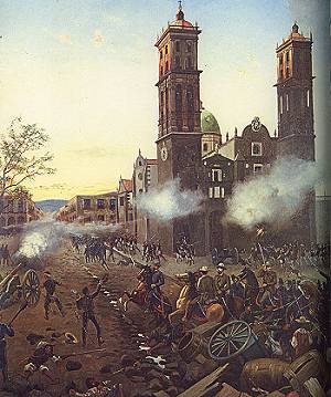
On the 5 May 1862, Zaragoza ordered his commanders to repel the invaders at all costs. Mexicans received unexpected help from the weather. After launching a brief artillery bombardment, the French discovered that the ground had become so muddy from heavy unseasonable downpours that maneuvering their heavy weapons was next to impossible.
Painting of Battle of Puebla

Bullets rained down on them from the Mexican troops that occupied the higher ground near the forts. At noon, the French commander ordered his troops to charge the center of the Mexican lines. But the lines held strong, and musket fire began to take its toll. Successive French attacks were rebuffed. The Mexican forces then counter‑attacked, spurred on by well-organized cavalry, led by Porfirio Díaz who would subsequently become President of Mexico.

As the afternoon wore on, and the smoke began to clear, it became apparent that the defenders of Puebla had successfully repelled the European invaders. The French troops fled back to Orizaba before retreating back to the coast to regroup. A crack European army had been soundly defeated by a motley collection of machete‑wielding peasants from the war‑torn republic of Mexico….

A few days later, on 9 May, President Benito Juárez declared that the Cinco de Mayo would henceforth be a national holiday.

Aftermath: the French return with reinforcements

Back in Paris, Napoleon was enraged. He ordered massive reinforcements and sent a 27,000-strong force of French military might to Mexico. This strengthened French army (under Marshal Elie Forey) took Mexico City in 1863, forcing Benito Juárez and his supporters to flee. Juárez established himself in Paso del Norte (now El Paso) on the US border, from where he continued to orchestrate resistance to the French presence. Supported by the conservatives, Maximilian finally ascended to the throne in May 1864. By this time, in the USA, the Unionists had taken Vicksburg, and the US government was considering its position. In May 1865, General Philip Sheridan led 50,000 US soldiers to ensure that French troops did not cross the Mexico‑USA border. Diplomatic pressure for a French withdrawal intensified and Napoleon III finally agreed to remove his troops in February 1866.

After the French had departed, President Juárez reestablished Republican government in Mexico, and put Maximilian on trial, ending an extraordinary period in Mexican history.

The significance of 5/05

With the passing of time, the Cinco de Mayo has assumed added significance because it marks the last time that any overseas power was the aggressor on North American soil.

In Mexico, the Cinco de Mayo is still celebrated with lengthy parades in the state and city of Puebla, and in neighboring states like Veracruz. There is at least one street named Cinco de Mayo in almost every town and city throughout the country.

In the USA, the Cinco de Mayo has been transformed into a much more popular cultural event, and one where many of the revelers think it commemorates Mexican Independence, not a battle. (Mexico’s Independence celebrations are in mid-September each year).

Many communities in the USA, especially the Hispanic communities, use Cinco de Mayo as the perfect excuse to celebrate everything Mexican, from drinks, music and dancing, to food, crafts and customs. The Cinco de Mayo has become not just another day in the calendar, but a very significant commercial event, one now celebrated with much greater fervor north of the border than south of the border.

Where to go to see more — Texas

General Ignacio Zaragoza died on September 8, 1862, only a few months after the Battle of Puebla. In 1960, the General Zaragoza State Historic Site was established in his birthplace, near Goliad, Texas, to commemorate his famous victory. In Zaragoza’s time, the town was known as La Bahía del Espíritu Santo.

Where to go to see more — Puebla

The Guadalupe and Loreto forts are in parkland, about 2 km north‑east of Puebla city center. The Fuerte de Guadalupe is ruined. The Fuerte de Loreto became state property in 1930. It is now a museum, the Museum of No Intervention (Museo de la No Intervención), complete with toy soldiers. The park has an equestrian statue of General Zaragoza and is the setting for the Centro Civico 5 de Mayo, with its modern museums, including the Regional Museum (history and anthropology), the Natural History Museum and the Planetarium (IMAX screen).
Atlantic and eastern Pacific hurricane names for 2011

 Other  Comments Off on Atlantic and eastern Pacific hurricane names for 2011
Apr 132011
 

Hurricanes are also known as typhoons or tropical cyclones. The table shows the World Meteorological Organization’s official list of 2011 hurricane names. Note that male and female names alternate. Names are often reused in future years, with the exception of the names of any particularly violent storms, which are officially “retired” from the list for a long time.

Atlantic, Gulf of Mexico and CaribbeanEastern Pacific
ArleneAdrian
BretBeatrix
CindyCalvin
DonDora
EmilyEugene
FranklinFernanda
GertGreg
HarveyHilary
IreneIrwin
JoseJova
KatiaKenneth
LeeLidia
MariaMax
NateNorma
OpheliaOtis
PhilippePilar
RinaRamon
SeanSelma
TammyTodd
VanceVeronica
WhitneyWiley
Xina
York
Zelda

In Mexico, the “official” hurricane season is from May 15 to November 30 each year for Pacific coast storms, and from June 1 to Novemebr 30 for Atlantic storms, though most hurricane activity is concentrated in the months from July to September.

This year, Philip Klotzbach and William Gray, researchers at Colorado State University, predict that 16 named storms will form in the Atlantic: 7 tropical storms,4 moderate hurricanes (1 or 2 on the Saffir-Simpson scale), and 5 severe hurricanes (3, 4 or 5 on the Saffir-Simpson scale).

For the Pacific coast, Mexico’s National Meteorological Service (Servicio Metrológico Nacional, SMN) is expecting 17 storms: 7  tropical storms, 6 moderate hurricanes (1 or 2 on the Saffir-Simpson scale), and 4 severe hurricanes (3, 4 or 5 on the Saffir-Simpson scale). The SNM publishes regular updates on hurricane activity (in Spanish) on its webpage and via its Twitter account: @huracanconagua.

Previous posts related to hurricane prediction:

Hurricanes and other climatic hazards are analyzed in detail in chapter 4 of  Geo-Mexico: the geography and dynamics of modern Mexico.

Are women better than men at gathering mushrooms on the slopes of a Mexican volcano?

 Other  Comments Off on Are women better than men at gathering mushrooms on the slopes of a Mexican volcano?
Apr 122011
 

This post summarizes the findings of an article entitled “Sex differences in mushroom gathering: men expend more energy to obtain equivalent benefits”, published in the July 2010 issue of Evolution & Human Behavior.

Men are often thought to have superior spatial abilities to women. However, recent research has suggested that such differences are task dependent. It is now commonly argued that differences in spatial abilities may date back to early human societies during the Pleistocene. At that time, men’s spatial skills became fine-tuned for successful hunting of animals that were constantly on the move, while women’s spatial skill-set developed to ensure success in gathering immobile plant resources.

In a nutshell, men are thought to find their way about using orientation, and women by memorizing landmarks. One study reported that men performed better than women in finding their way through unfamiliar woodland, whereas another study showed how women exploring a farmers market in Santa Barbara, California, could remember where individual food items were more accurately than men.

Despite these earlier studies, the male/female differences in spatial skills had never been tested in appropriate circumstances in the field prior to the research carried out by four enterprising Mexican researchers led by Luis Pacheco-Cabos of the National University (UNAM).

The setting

The team studied the foraging techniques and success rate of men and women from a small village in Tlaxcala as they searched for edible mushrooms on the slopes of La Malinche volcano (Malintzin).

The small rural community of San Isidro Buensuceso has about 8,000 Nᨵatl-speaking inhabitants. The villagers have a long history of collecting mushrooms. Most mushroom collecting takes place during the summer rainy season. The vegetation in collecting areas is relatively open pine-oak forest, though the precise mix of species varies with altitude.

La Malinche Volcano

La Malinche Volcano

Each small group of mushroom collectors was followed by a researcher who recorded their movements and the weight of mushrooms collected. The exercise was carried out at seven different sites, most more than 3000m above sea level, through relatively open forest in terrain that included steep gullies carved into the flanks of volcano. The researchers were continuously monitored to record data enabling the calculation of the energy they expended in kilo-calories (kcal). Collectors gathered up to 9.5 kg of mushrooms in a single trip.

What were the teams key findings?

Although men and women collected similar quantities of mushrooms, men did so at significantly higher cost. They traveled further, to greater altitudes, and had higher mean heart rates and energy expenditure (kcal). They also collected fewer species and visited fewer collection sites.

Women used their superior powers of memorizing object location to collect more species, and visit more collection sites than men, obtaining more mushrooms during the same period of time, with less energy expenditure.

What does this mean?

The results suggest that differences in spatial ability between men and women are task-dependent. In terms of search strategies developed for gathering wild mushrooms, and presumably other wild plants, women outperform men. The women proved to be more efficient foragers than men in energy efficiency terms since they collected significantly more mushrooms while expending significantly less energy in doing so.

The researchers did not publish any calculation for the energy efficiency of mushroom collectors for comparison with the figures quoted in: The energy efficiency of farming in Mexico and elsewhere. However, based on their data, and assuming that 3 grams of raw mushrooms are approximately equivalent to 1 calorie, the energy efficiency for mushroom pickers on the slopes of La Malinche volcano must be somewhere between 0.5 and 1.7, with men tending towards the lower value. An energy efficiency of 1.0 would mean that the energy expended in gathering mushrooms is roughly the same as the calorific energy they contain.

The researchers conclude that similar studies are now needed for other cultural groups, and for the gathering of different resources, such as firewood.

Source:

Luis Pacheco Cobos, Marcos Rosetti, Cecilia Cuatianquiz, Robyn Hudson: “Sex differences in mushroom gathering: men expend more energy to obtain equivalent benefits”, Evolution & Human Behavior, July 2010 (Vol. 31, Issue 4, Pages 289-297).

Chiles, one of Mexico’s heritage crops

 Other  Comments Off on Chiles, one of Mexico’s heritage crops
Apr 092011
 

Chiles (Capsicum spp.) have been cultivated in Mexico for centuries and are a vital ingredient in Mexico’s traditional cuisine, recently recognized by UNESCO as an “Intangible Cultural Heritage of Humanity.” Spicy chiles also have numerous medicinal uses. Graphical representations of chiles have even been used as a national symbol.

Chiles are native to Mexico and central America. Evidence for chiles in the diet of indigenous groups in Puebla’s Tehuacán Valley dates back at least as far as 6500BC; by 4100BC, the plant was already domesticated.

Chiles

Chiles. Photo: zoonabar (flickr); creative commons license

There are more than 100 varieties of chiles, grouped into 22 groups of green chiles and 12 of dried chiles. Green chiles by far the most important in volume and value of production and trade. Mexico remains the world’s leading exporter of green chiles and is the sixth largest exporter of dried chiles. The world’s leading producer of green chiles, almost entirely for domestic consumption, is China.

The ideal conditions for cultivating chiles are:

  • growing season temperatures of 18-27̊C daytime and 15-18̊C during the night.
  • rainfall of 600-1250 mm/yr, with no marked dry season.
  • light, humus-rich soils with adequate moisture retention and drainage
  • soils with a pH between 5.5 (slighty acidic) and 7.0 (neutral)
  • growing season of at least 120 days

Crop yields can be adversely affected by:

  • plagues,
  • plant diseases,
  • climatic hazards, such as hailstorms, rainstorms (fields need efficient drainage systems) and frost, the risk of which is countered by burning waste to create smoke to maintain temperatures above freezing

Time frame for cultivation

  • on commercial chile farms, seeds are usually sown in enclosed, heated, nursery beds, since temperatures of 20-24̊C are considered ideal for germination
  • seedlings are transplanted after 25-35 days when they are about 10-20cm in height – optimum yields require 20,000-25,000 plants per hectare
  • the first flowers appear 1-2 months later, by which time the plant is 30-80 cm tall
  • the first green chiles ripen about a month after that; chiles can then be picked every week or so for up to 3 months in rain-fed fields, or sometimes over an even longer period in irrigated fields.

In ideal circumstances, harvesting is possible all year. There are two major, overlapping harvest periods each year, with a fall-winter crop from December-August, and a spring-summer crop from June to March.

Yields vary greatly, reflecting different qualities of soil, water supply and technification employed. The average yield across Mexico is 14-15 metric tons/hectare. Yields in Zacatecas (which has a larger cultivated area of chiles than any other state in Mexico) are only 7 tons/ha, while yields in Sinaloa reach as high as 40 tons/ha.

Types of chile grown in Mexico

The most commonly grown chiles in Mexico are jalapeño, serrano, habanero, poblano and morrón (bell pepper). Seven varieties of green chiles represented 90% of Mexico’s total production of chiles in 2008, and 60% of its total revenue from chiles. Chiles vary in color, heat, size and texture:

Even for a single species, the “heat” of its chiles varies from one plant to the next, as well as from one soil or location to another. The heat of chiles is measured in Scoville units. The hottest chile is generally thought to be the habanero (100,000-445,000 Scoville units). By comparison, the jalapeño is 2,500-5,000 units and the morrón chile (bell pepper) registers 0 Scoville units.

Main source for statistics (pdf file): Un panorama del cultivo del chile, SAGARPA: Servicio de Información Agroalimentaria y Pesquera, June 2010. [accessed January 28, 2011]

Agriculture in Mexico is analyzed in chapter 15 of Geo-Mexico: the geography and dynamics of modern Mexico. Ask your library to buy a copy of this handy reference guide to all aspects of Mexico’s geography today! Better yet, order your own copy…

Mexico’s pearl collection industry: from boom to bust in less than 100 years

 Other  Comments Off on Mexico’s pearl collection industry: from boom to bust in less than 100 years
Mar 282011
 

In a previous post, we looked at the early history of pearl collecting in Mexico. In this post, we carry the history forward to the present-day.

The search for oyster shells with pearls inside was revolutionized after 1874 when larger vessels, equipped with diving suits and accompanying equipment, first entered Mexican waters. The newer methods permitted access to shells in much deeper water, and lengthened the season, greatly increasing the industry’s productivity. The dangers associated with pearl hunting changed. Equipment failures and lax supervision cost many lives. According to Kunz and Stevenson, divers confined to diving suits for hours at a time frequently suffered rheumatism, paralysis (due to compression and sudden temperature changes) and partial deafness. On the other hand, diving suits reduced shark attacks.

The conditions in Baja California were so favorable for pearling that by 1889, within a few years of its incorporation, the Compañía Perlífera de la Baja California (based in La Paz, and employing about 900 men) had come to completely dominate the world pearling industry. One of the largest pearls found in the Sea of Cortés was one weighing 372 grains found near Mulegé in 1884. On arrival in Paris, its value was estimated at 85,000 francs (about 16 600 dollars at the exchange rate of the time). A 400-grain pearl, found in the same area, now forms part of the Spanish crown jewels.

A 1903 article in The New York Times says that the Baja pearl industry had produced more than two million dollars worth of pearls in 1902, including some of the “finest jewels of this kind found anywhere in the world”. The article describes several individual pearls, and emphasizes that the area is “noted for its fancy pearls – that is to say, the colored and especially the black ones”. As mentioned earlier, the native Indians wore fire-blackened pearls. This seems to have been a particularly prescient choice, given the extremely high premiums long placed on natural black pearls. Even today, at least one firm in Baja specializes in producing cultured black pearls from rainbow-lipped oysters.

As the twentieth century progressed, cultured and artificial pearls were able to out-compete natural pearls in terms of price and availability. By 1936, a century of rampant overfishing of oyster beds had depleted natural stocks to the point where recovery was unlikely. Finding fifteen to twenty small pearls required the harvesting of a ton of oyster shells. To cap it off, an unknown disease then spread rapidly through the remaining oysters, virtually wiping them out.

poster for steinbeck's "the pearl"

By the time the American writer John Steinbeck arrived in Baja in 1941, the glory days of Mexican pearling were over. While in La Paz, Steinbeck came across a legendary (and cautionary) local tale about the greed associated with finding a massive pearl. The story became the catalyst for his novella “The Pearl“, published in 1947, in which Kino, an impoverished pearl diver, finds a huge pearl, “The Pearl of the World” which promises to transform his life. It does, but not in the way one might expect. Kino becomes a brutal sociopath; the story, which was later turned into a movie starring Pedro Armendáriz and María Elena Marquéz, becomes a dark tale of the costs of defying traditional customs.

Today, very few natural pearls are harvested in the Sea of Cortés, but several Baja California firms cultivate pearls, helping to extend a centuries-old industry into the present. It is especially appropriate, therefore, that the city of La Paz, once the center of the world’s pearling industry, is still known, even today, as the “Pearl of the Sea of Cortés”.

Sources / Further reading:

  • Anon. Important Pearl Fisheries on the Coast of California. The New York Times, June 14, 1903.
  • Hardy, R. W. H. 1829 Travels in the Interior of Mexico in 1825, 1826, 1827 and 1828. London: Henry Colburn & Richard Bentley. Reprinted in 1977, Texas: Rio Grande Classics.
  • Kunz, G. F., and Stevenson, C. H. The Book of the Pearl: Its History, Art, Science and Industry. Dover. 2001.
  • Landman, Neil H and Mikkelsen, P. Pearls: A Natural History (Harry N. Abrams, 2001)
  • Mayo, C. M. Miraculous Air: Journey of a Thousand Miles through Baja California, the Other Mexico. Milkweed Editions. 2007.

This post is an edited version of the original article which appeared on MexConnect.

Where is the best place in Mexico to celebrate the Spring Equinox?

 Other  Comments Off on Where is the best place in Mexico to celebrate the Spring Equinox?
Mar 202011
 

The main pyramid at the Maya site of Chichen Itza in the Yucatán Peninsula is the most popular site in Mexico for crowds to gather and celebrate the Spring Equinox (March 20-21). The Maya were accomplished astronomers and were able to accurately predict equinoxes, eclipses and other celestial events hundreds of years in advance.

Crowds gather to witness the serpent descend the pyramid
Crowds gather to witness the serpent descend the pyramid. Original upload by shawn_christie1970 (Flickr).

The main pyramid at Chichen Itza, known as the Pyramid of Kukulkan, has some unusual properties which researchers are still trying to explain. It is so precisely aligned that for a day or two either side of the Spring Equinox, the light falling on one side of the pyramid creates undulating shadows that look like a serpent slithering down the pyramid steps. The effect is best seen between 4 and 5 pm.

The slithering serpent is not the only surprise that the Pyramid of Kukulkan has in store for visitors. Kukulkan was a Mayan deity, the “feathered serpent”, more usually known in central Mexico as Quetzalcoatl. The Pyramid of Kukulkan is linked to the quetzal bird, because depictions of Kukulkan often show the distinctively long feathers of the quetzal. Standing in front of the pyramid and making a single hand clap results in an echo from the pyramid’s staircase, an echo which sounds like the downward chirp of a quetzal bird.

David Lubman has proposed that this may be the earliest sound recording so far discovered anywhere on the planet. We may never know whether it was originally accidental or intentional, but Lubman makes a strong case for this chirp being a deliberate representation of the call of the Respendant Quetzal bird, a bird described in Peterson and Chalif’s Field Guide to Mexican Birds as “the most spectacular bird in the New World.” Quetzal birds were sacred to the Maya, and their feathers were highly prized; the birds were formerly common in the rainforest which originally cloaked this entire region.

Sources

Original article on MexConnect.com: Did you know? Mayan architects built world’s oldest sound recordings

Lubman, David (1998) “Archaeological acoustic study of chirped echo from the Mayan pyramid at Chichen Itza, in the Yucatan Region of Mexico… Is this the world’s oldest known sound recording?“. Paper presented to the 136th Meeting of the Acoustical Society of America, October 1998.

Lubman, David (2002) “More on the Mayan Pyramid“. Article on the website of the Orange County Regional Chapter of the Acoustical Society of America:

Mexico’s long romance with pearls began way before the arrival of Spanish explorers

 Other  Comments Off on Mexico’s long romance with pearls began way before the arrival of Spanish explorers
Mar 192011
 

This post highlights the pearl, the beautiful birthstone associated with the month of June. Few people realize that Mexico was once the world’s major source of pearls.

The history of pearl collecting in Mexico goes back a very long way. When Spanish explorers sailed into the Sea of Cortés (Gulf of California) in the early 1530s they encountered Pericú Indians wearing necklaces strung with red berries, shells and blackened pearls. It is believed that pearl jewelry in the region dates back about 7000 years. Lacking metal knives, the only way the Indians could prize open the oyster shells and find pearls was by throwing the shells into a fire, hence the charred pearls. The Spanish explorers quickly recognized that their knives would yield lustrous milky-white pearls, the equal in quality of any found in the Middle East or Asia.

Harvesting pearls became a priority as the Spaniards tried to establish permanent settlements on the arid peninsula now known as Baja California. From 1535 to Mexican independence in 1821, thousands of pearls were dispatched to Europe on a regular basis, where they were incorporated into the lavishly decorated regalia of many notable European courts. During the period of Jesuit missions in Baja (1697 to 1768) pearl collecting was restricted, but even then illegal traffic in pearls persisted.

Cover of Pearls, a natural history

Following Mexico’s independence, other European nations besides Spain sought access to Baja pearls. For instance, English traveler R. W. H. Hardy arrived in Mexico in 1825, to prospect for pearls and coral on behalf of the General Pearl and Coral Fishery Association of London. Hardy was proud of having “travelled over a part of Mexico visited by no other European” and greatly valued the local knowledge of the coastal Indians of north-western Mexico. Unlike most of his contemporaries, Hardy developed a very positive view of the Indians he met, and felt that they had far more to offer outsiders than just the location of natural resources.

The pearling industry in Baja really took off in the mid-nineteenth century as enterprising, business-minded armadores hired native divers (mainly Yaqui Indians from Sonora) to explore the numerous shallow coves between La Paz and Mulegé, and around the islands including Cerralvo and Isla Espíritu Santo. Diving was a seasonal occupation, primarily carried out during the warm months from May to late September. At other times of the year, water temperatures and higher winds made diving difficult or impossible. The Indian divers worked from rustic canoes for up to five hours a day, armed with a short sharpened stick which did double duty, to pry oyster shells off the seabed and to ward off lurking sharks and manta rays. The divers earned a share of the catch, but their rewards were meager and benefits few.

Citing a 1859 paper, Kunz and Stevenson report that by 1857, 95,000 tons of oysters had been removed from the Sea of Cortés, “yielding 2770 pounds of pearls, worth $5,540,000.” Mexico’s high society also lusted after pearls, leading Empress Carlota to remark how the ladies attending a theater event all wore dresses “covered in pearls”.

Mexico’s pearling industry was on the edge of world-wide fame. In a future post, we will see how the introduction of newer technology after 1870 revolutionized pearl collecting in Mexico, bringing a boom that would last well into the twentieth century.

Sources / Further reading:

  • Hardy, R. W. H. 1829 Travels in the Interior of Mexico in 1825, 1826, 1827 and 1828. London: Henry Colburn & Richard Bentley. Reprinted in 1977, Texas: Rio Grande Classics.
  • Kunz, G. F., and Stevenson, C. H. The Book of the Pearl: Its History, Art, Science and Industry. Dover. 2001.
  • Landman, Neil H and Mikkelsen, P. Pearls: A Natural History (Harry N. Abrams, 2001)
  • Mayo, C. M. Miraculous Air: Journey of a Thousand Miles through Baja California, the Other Mexico. Milkweed Editions. 2007.

This post is an edited version of the original article which appeared on MexConnect.

The purity of illicit drugs declines with distance from the Mexico-USA border

 Other  Comments Off on The purity of illicit drugs declines with distance from the Mexico-USA border
Mar 122011
 

The concept of distance decay is often used by geographers when trying to describe and explain spatial patterns.

Distance decay is the “attenuation of a pattern or process with distance” (Dictionary of Human Geography, Blackwell 1986). It is one of the fundamental concepts behind many geographic models (e.g. Christaller, von Thünen) and the basis of W. Tobler’s first law of geography: “everything is related to everything else, but near things are more related than distant things.” (Tobler 1970)

A recent study published in Addiction found that the principle of distance decay applies to the purity of drugs sold in the USA. Most drugs entering the USA do so via the Mexico-USA border. It presumably costs more, and entails higher risks, to transport drugs further north than just over the border.

The health risks associated with illicit, non-prescription drugs are related to drug purity. Addiction rates also vary with purity. Surprisingly, the geographic pattern of drug purity within a single country has rarely been investigated in detail before.

The researchers analyzed the drugs seized in about 240,000 drugs incidents for the period 1990-2004. They also looked at the correlation between drug purity and the time, and size, of each drug seizure.

The researchers found that the purity of methamphetamine, cocaine and heroin generally decreased with distance from the border. Beyond 1450 km (900 miles), however, heroin purity increased again towards the northeast. The pattern for heroin, and a similar pattern for methamphetamine after 2000, suggest that perhaps some of these drugs were imported via the eastern seaboard of the USA (heroin) or from southeastern Canada (methamphetamine). The findings also suggest that methamphetamine from Canada may be on a larger scale than previously thought.

For all three drugs, the purity of small amounts seized close to the border showed more variation than was true for seizures further north.

Given the conclusions of this study, researchers may be better able to predict the areas which are likely to have higher rates of drug dependence and overdoses.

And some people still think geography is boring?

Sources: Cunningham J.K., Maxwell J.C., Campollo O., Cunningham K.I., Liu L.M., Lin H.L.: “Proximity to the US-Mexico border: a key to explaining geographic variation in US methamphetamine, cocaine and heroin purity”. Addiction. 2 August 2010.

Tobler, W. 1970 “1970: a computer movie”. Economic Geography 46: 234-240.

How sustainable is commercial fishing in northwest Mexico?

 Other  Comments Off on How sustainable is commercial fishing in northwest Mexico?
Mar 092011
 

Mexico’s fishing industry now accounts for only 0.24% of gross national product. The relatively shallow waters off the Pacific coast and abundance of plankton in waters cooled by the Californian current make for particularly good fishing in the north-west. Together, Sinaloa (23%) and Sonora (22%) account for about 45% of the national total. Fishing is also economically important in Veracruz (8%), Baja California Sur (6%), Campeche and Baja California (5% each) and Yucatán. Almost three quarters (72%) of the total annual catch of 1.5 million metric tons is landed at Pacific coast ports such as Guaymas, Mazatlán and Manzanillo. [excerpt from Geo-Mexico page 97]

A study of fisheries in the region by a team of researchers from the University of California San Diego’s Scripps Institution of Oceanography and the Centro para la Biodiversidad Marina y la Conservación in La Paz, Baja California Sur makes for interesting reading.

The team looked at fisheries data for northwest Mexico, defined as including the coasts of five states: Baja California, Baja California Sur, Sonora, Sinaloa and Nayarit. They conducted field research and then examined the connections between local fisheries data and the geography and habitats of the various fish species. They found a close tie between the geography of local habitats and the (local) decision as to which fish species to catch (clams, red snapper, shrimp). They also found that small-scale local fishing, which relies on thousands of pangas, remains an important component of local economies.

Proposed fishing regions in NW Mexico
Map of five proposed fishing regions in NW Mexico. Image credit:University of California-San Diego

The researchers concluded that the area is not one homogeneous unit, but can be best divided into five overlapping sub-zones (see map) differentiated on the basis of such characteristics as whether the coast is rocky or has mangroves, the presence of reefs or sandy seafloor, the coastal geology and latitude.

Hence, the current fisheries strategy of treating the entire region as a single area is not the most effective way to manage fisheries. According to the researchers, their five-fold zonation would allow “ecosystem-based management” in each sub-region. This would encourage management techniques which ensure long-term conservation of particular fish stocks and help increase fishing’s sustainability.

However, it also requires using different strategies for large-scale industrial fishing than for local, small-scale panga-based activity. The researchers remain optimistic that small-scale fishing has a good future, but only provided industrial-scale fishing is well monitored and controlled.

Source: University of California-San Diego (2011, January 27). Study finds common ground for ecosystems and fishing in Northwest Mexico. Retrieved January 28, 2011.

The pros and cons of floriculture in Mexico

 Other  Comments Off on The pros and cons of floriculture in Mexico
Mar 052011
 

In a previous post – Mexico’s flower power – we looked at the Mexico’s floriculture sector. Mexico’s immense biodiversity, one of the greatest on the planet, and its variety of climates have encouraged the cultivation of ornamental flowers, principally for the domestic market, but also for export. In this post, we present a summary of the pros, cons and impacts of floriculture in Mexico.

Advantages that Mexico has for floriculture:

  • large internal market
  • long tradition of growing ornamental flowers
  • rich biodiversity – Mexico has more than 30,000 species of flowering plants, one of the world’s most diverse floras
  • competitive labor costs
  • variety of climates, from tropical to temperature
  • relative proximity to the USA compared to other major flower producers

Disadvantages of/for floriculture

  • the required transport by air is expensive, and companies relying on third-party carriers may lose access to their export markets if the airline changes its scheduled routes. For example, Finca Argovia, a grower of exotic flowers in Chiapas (150 species, 7 million stems a year, including orchids and anthuriums) would suffer if flights from Tapachula to Mexico City were stopped. These flights are the essential first leg of Argovia’s access to international markets.
  • demand for flowers is highly seasonal and having perfect blooms available for certain specific days (such as Valentine’s Day, 14 February) is critical to a grower’s success.
  • flowers grown in open fields (the majority of Mexico’s ornamental flowers) are more susceptible to insect pests and weather-related hazards and damage than those grown in greenhouses.
  • representatives of flower growers’ organizations claim that they have to compete with “contraband” flowers that originate in Ecuador, Colombia, Costa Rica and the Netherlands, and are brought into Mexico from the USA.

Positive impacts of floriculture in Mexico

  • employment
  • export income
  • added aesthetic attraction (hotels, churches, restaurants, markets)

Negative impacts of floriculture in Mexico

  • runoff of agricultural chemicals into groundwater and local streams
  • many essential inputs (specialist pesticides, fertilizers, seeds, etc) have to be imported

For interest
Mexico’s national flower is the dahlia. To find out more, read this MexConnect article about Mexico’s national flower.

Mexico’s flower power…

 Other  Comments Off on Mexico’s flower power…
Mar 022011
 

Given its diversity of climates and immensely varied natural flora (see Mexico’s mega-biodiversity, Mexico is ideally suited for commercial floriculture (flower growing).

Helped by government support, floriculture expanded rapidly in the 1980s and 1990s. About 14,000 hectares of agricultural land are devoted to ornamental flowers, with 10,000 growers concentrating on 50 different varieties, the most important of which are gladioli, roses, chrysanthemums, carnations, birds-of-paradise and the nard. Mexico’s flower growers produce 83,000 tons/yr of flowers, 80% of them destined for the domestic market. Most flower farms are smallholdings of 1-3 hectares in size, though there are also about 150 high-tech, greenhouse-based operations for the export market.

In addition to the area dedicated to ornamental flowers, a further 9,000 hectares are devoted to plants and flowers used in the cosmetics and food flavoring industries.

The state of Mexico has the largest area devoted to floriculture in the country, centered on Villa Guerrero. Other states important for ornamental flowers are Baja California, Coahuila, Colima, Chiapas, Guanajuato, Guerrero, Jalisco, Michoacán, Morelos, Puebla, Querétaro, Tabasco, Veracruz, and, in the last five years, Yucatán.

The internal market for ornamentals is severely constricted by a lack of space in Mexico City’s wholesale market; the resulting congestion results in about 20% of all the fresh flowers arriving daily at the market having to be destroyed.

Mexico’s nationwide production of flowers is worth about 1 billion dollars a year. Only a small percentage of production is exported, mainly to the USA, with smaller amounts to Canada and Europe. While Mexican flower exports are currently worth some 50 million dollars, exports from Columbia are worth 550 million dollars and those from Ecuador and Costa Rica about 150 million.

Related posts: