The geography of Mexico’s beer industry

 Maps, Other  Comments Off on The geography of Mexico’s beer industry
Jan 292015
 

In a previous post – The emergence of two major beer-makers in Mexico – we looked at how Mexico’s beer industry came to be dominated by two large players: Femsa and Modelo, both now owned by foreign corporations.

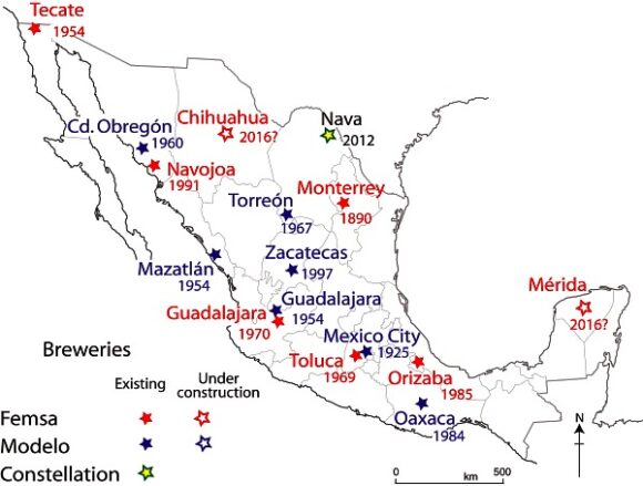
The map below shows the location and date of inauguration of all major breweries in Mexico.

The location and inauguration dates of Femsa and Modelo breweries in Mexico

The location and inauguration dates of Femsa and Modelo breweries in Mexico

How large is Mexico’s market for beer?

A 2010 report from the national beer industry claims that the average annual consumption of beer in Mexico is 60 liters per adult, a figure that has not changed significantly in the last 20 years. The equivalent figure in Germany is 120 liters a person, so there is still considerable potential for growth. Mexico’s breweries provide about 80,000 jobs directly and a further 800,000 indirectly.

Total beer sales each year are worth as much as 20 billion dollars. The value of sales has risen sharply, at about 5% a year, due mainly to higher exports. Mexico has become the world’s second largest beer exporter, after the Netherlands, and is the world’s sixth largest producer and consumer of beer, brewing over 8.6 billion liters a year.

The USA is the main export market. Five of the 25 most popular brands in the USA are Grupo Modelo beers: Corona, Modelo Especial, Corona Light, Pacífico and Negra Modelo. This has helped Grupo Modelo, Mexico’s leading brewer, become the world’s sixth largest brewer. Modelo’s Corona beer has been the #1 imported beer in the USA since 1997. It is one of the world’s top five beers in terms of sales, even though it is not especially popular in Mexico!

One of Modelo’s fastest growing export markets is China, where it has rapidly become the second most popular imported beer. In Mexico’s domestic beer market, Modelo and Femsa face increased competition from imported beers such as Budweiser, Miller and Heineken.

There are several other smaller breweries in addition to those owned by Femsa and Modelo. One significant trend, echoing other regions in North America, has been a marked upswing in the number of small, specialist, boutique breweries, such as Cervecería San Angel and the Santa Fe Beer Company in Mexico City and Minerva Brewery in Guadalajara. Other popular brands of craft beer include Perro Negro from Guadalajara, Insurgente from Tijuana, Libertadores from Michoacán and the varied products of the Baja Brewing Company from Los Cabos.

These smaller “craft” breweries produced 10.5 million liters of beer in 2014, according to the Mexican Beer Makers Association (Asociación de Cerveceros de la República Mexicana, Acermex), and account for only 0.16% of the total market, but their share of the market is growing at more than 40% a year. The association hopes that smaller breweries can enjoy as much as 1% of the market by 2016.

The rise of craft beers has seen a corresponding proliferation of specialist pubs that stock pale ales, pilsners, porters, stouts and wheat beers in the trendier districts of all the major cities, including Mexico City, Guadalajara, Monterrey and Querétaro.

In Guadalajara, in 2008, two local craft breweries – Cerveceria Minerva and  Cerveceria Revolución – co-founded the Guadalajara Beer Festival to showcase Mexican their products and introduce previously unavailable European import brands. The festival is now a three day event that attracts as many as 30,000 visitors a year; it claims to be Latin America’s largest beer festival.

Mexico’s economic geography is analyzed in chapters 14–20 of Geo-Mexico: the geography and dynamics of modern Mexico. Buy your copy of this invaluable reference guide today!
Mexico has seven of the world’s 100 best hotels

 Mexico's geography in the Press  Comments Off on Mexico has seven of the world’s 100 best hotels
Jan 262015
 

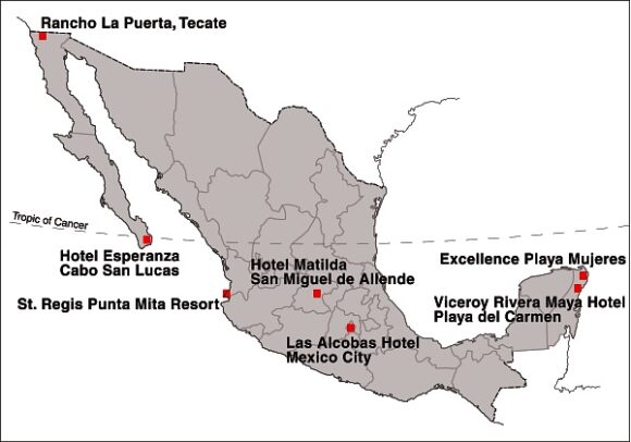
A survey of more than 75,000 Condé Nast Traveler readers placed seven Mexican hotels in the world’s top 100.

Location of Mexico's Top Seven Hotels

Location of Mexico’s Top Seven Hotels

Mexico’s top hotel (#15 in the rankings) was the Viceroy Rivera Maya hotel, in Playa del Carmen (Quintana Roo). It was joined in the top 100 by Rancho La Puerta in Tecate (Baja California), St. Regis Punta Mita Resort (Nayarit), Las Alcobas hotel (Mexico City), Hotel Matilda in San Miguel de Allende (Guanajuato), Hotel Esperanza in Cabo San Lucas (Baja California Sur) and the Excellence Playa Mujeres (Quintana Roo).

In related news, Grupo Posadas is investing one billion dollars over the next three years to open 49 new hotels, many of them in the firm’s Fiesta Americana chain. Meanwhile, at the opposite end of the hotel spectrum, Motel 6, the “McDonald’s of the hotel industry”, which has 1,200 locations in the USA and Canada, is opening 30 hotels in Mexico within the next three years.

The operator of the Motel 6 chain, G6 Hospitality, will introduce both its brands: Motel 6 and Estudio 6 (designed for extended stays) during its first foray into Latin America. The first of the new hotels will open in Salamanca (Guanajuato) in late-2015, with additional locations to follow, including Mexico City, Monterrey and several resort destinations.

Related posts:

Christmas in Mexico, according to one news agency

 Other  Comments Off on Christmas in Mexico, according to one news agency
Jan 252015
 

According to its website, “The QMI Agency is French and English Canada’s leading news reference for daily, intermittent and event-driven needs. Its offering most notably includes texts, images, videos and other interactive content.”

QMI’s Facebook page promotes its graphics department which “creates infographics for use throughout our chain” and boasts that “QMI Agency provides reliable, complete and up-to-the-minute news coverage over a full range of platforms.” And, indeed, many of the infographics shown on its Facebook page are very well designed, interesting, colorful and informative.

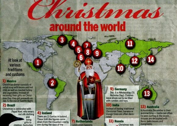
QMI-Christmas

Infographic from Niagara Advance newspaper for 25 December 2014

However, this infographic attributed to the QMI Agency, published in the Niagara Advance newspaper for 25 December 2014 (which Geo-Mexico happened to see while admiring Niagara Falls) was far less convincing. Entitled “Christmas around the world”, this particular infographic  took a “look at various traditions and customs”, and opened with a description intended to summarize Christmas in Mexico:

Mexico: Christmas dinner consists of oxtail soup with beans and hot chili, as well as roasted turkey and vegetables. Instead of receiving their gifts on Christmas Day, they get presents on Jan. 5, the eve of Twelfth Night.”

Hmm… really? As we have noted many times on Geo-Mexico, Mexican cuisine varies regionally. Even so, if any reader knows where “oxtail soup with beans and hot chili, as well as roasted turkey and vegetables” is the typical menu for Christmas, please let us know, to add to our list of regional delights.

As for presents being received on “Jan. 5, the eve of Twelfth Night”, err… no. The Mexican tradition of gifts on Three Kings Day involves Mexican children stuffing shoes (or a  box) with straw, and leaving them outside their bedroom door on the night of 5 January, in anticipation of finding gifts (new toys) the following morning, the morning of 6 January, Three Kings Day.

Related posts

Tourist numbers for Cancún, 2000-2014

 Updates to Geo-Mexico  Comments Off on Tourist numbers for Cancún, 2000-2014
Jan 212015
 

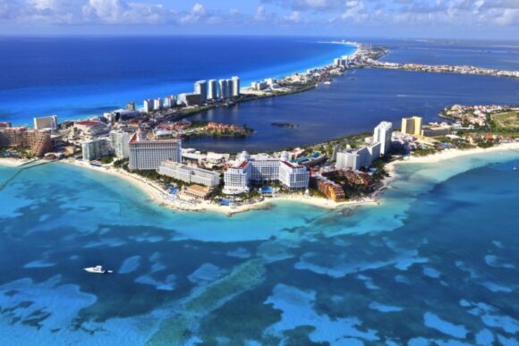
The table shows the number of tourists (national and international) visiting Cancún, Quintana Roo, Mexico, 2000-2013.

Cancún by Arthur Gonoretzky (Flickr)

Cancún by Arthur Gonoretzky (Flickr)

From 2000 until 2011, tourist numbers fluctuated between 2.8 and 3.3 million. Since 2011, tourist numbers have risen sharply, to 3.6 million in 2012, 4.1 million in 2013 and a preliminary estimate of 4.3 million for 2014.

YearNumber of touristsYearNumber of tourists
20003 043 00020083 265 591
20012 986 00020092 878 811
20022 826 00020103 015 690
2003n/a20113 115 177
2004n/a20123 642 449
20053 072 00020134 093 942
2006n/a20144 300 000 (estimate)
20073 004 8022015?

Cancún currently has more than 3000 condominium units and more than 35,000 hotel rooms. According to the first draft of the Programa de Desarrollo Urbano del Centro de Población Cancún 2014-2030, the city could have as many as 46,000 hotel rooms by 2030.

This projection is well below the earlier estimate, made in 2013, of 64,000 rooms by 2030, but the new figure is claimed to be more in line with planned improvements to local water supply. The development of Cancún has often been criticized for paying insufficient attention to considerations of urban density, water supply and environmental impacts.

 Related posts:

The Codex Mendoza, a key resource about Aztec times, can now be viewed online

 Books and resources  Comments Off on The Codex Mendoza, a key resource about Aztec times, can now be viewed online
Jan 192015
 

The Codex Mendoza, which we have referred to in several previous posts, can now be viewed via an amazing online interactive resource organized by INAH, Mexico’s National Institute of Anthropology and History, in association with Oxford’s Bodleian Library and King’s College, London.

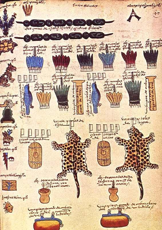
Compiled in 1542, and richly illustrated, the Codex Mendoza is one of the key primary sources from Aztec times. It was completed at the instigation of Spanish viceroy Antonio de Mendoza and provides exquisite details about Aztec history, the expansion of their “empire” and the territorial tributes that they received from every quarter of their dominions. The Codex also chronicles daily life and social dynamics.

Tribute page from the Codex Mendoza

Tribute page from the Codex Mendoza

The interactive online version has images of the entire document and allows viewers to mouse-over the original text for translations into English or modern Spanish. Clicking on individual images offers more detailed explanations and information.

The digital codex can be viewed online, or downloaded through Apple’s App Store as a 1.02-gigabyte app.

The original Codex Mendoza resides in the library of Oxford University.  (The ship carrying it from New Spain (Mexico) back to Spain in colonial times was attacked by French buccaneers. The booty was subsequently divided up, with the Codex eventually reaching the university library.)

The online Codex Mendoza is  a truly amazing resource. Hopefully, some of the other Mexican codices that currently reside in Europe, too also be “virtually repatriated” in the near future, making it much easier for Mexican scholars to consult them.

Related posts:

Video documentation of the Lacondon Indians in Chiapas

 Books and resources  Comments Off on Video documentation of the Lacondon Indians in Chiapas
Jan 162015
 

The Lacondon Maya are one of the most isolated and culturally conservative of Mexico’s numerous indigenous peoples. Their homeland is in the remote Lacondon Jungle in eastern Chiapas, close to the Guatemalan border. The Lacondon were the only Mayan people not conquered or converted by the Spanish during the colonial era. Until the mid-20th century they had little contact with the outside world, while maintaining a sustainable agricultural system and practising ancient Mayan customs and religion.

This short two-part video by Joel Kimmel (Part One above; Part Two below) briefly traces the history of the Lacandon back to the classic Mayan civilization. The videos document their successful, slash and burn, rotating, multicrop, subsistence agricultural lifestyle, steeped in religious ritual, and sustained over centuries in small isolated groups in the almost impenetrable Lacandon jungle.


The film then looks at the more recent outside influences that resulted in the near extinction of the Lacandon by the mid 20th century. Today their population has increased again and is estimated at between 650 and 1000, living in about a dozen villages. The second video focuses on the Lacondon’s confrontation with the modern world over the past four decades. One group, the “southern” Lacandon have opted for Christianity and the trappings of modern life, whilst some in the “northern” group, centered around the village of Naja, near the Mayan ruins of Palenque, attempt to maintain the old customs and religion. The video ends with the thoughts of a former Director of Development at Na Bolom, regarding the possibility, and immense difficulty, of trying to preserve what remains of their language, cultural heritage and ecological knowledge, treasures the world can ill afford to lose.

The videos introduce speakers and photos from the internationally famous Casa Na Bolom, in San Cristóbal de la Casas, Chiapas. This scientific and cultural research institute was founded in 1951 by Danish archeologist Franz Blom and his Swiss wife, Trudy Blom, journalist, photographer and later environmental activist. They devoted their lives to documenting the cultural history of the Lacondon people and life in the Chiapas jungle and advocating for the survival of both. Following Trudy Blom’s death in 1993, the Asociación Cultural Na Bolom has continued to operate the center as a museum, research and advocacy center, and tourist hotel. It houses an archive of over 50,000 photographs, and other documentation created by scholars over the decades.

The two videos provide visual proof of the forces of modern Mexico that have threatened the existence of the Lacondon way of life – government roads opening up the jungle to loggers and other settlers, logging permits resulting in massive clearcutting of the mahogany forests , the arrival of tourism, Coca-Cola and canned foods, mainstream education and modern technology like satellite television.

Not covered in the video is the fact that a Mexican presidential order in 1971 granted 614,000 acres to the Lacandon Community, recognizing their land rights over the, by then, more numerous settlers who had been allowed to colonize the Lacandon Forest under previous governments. This, however, has brought the Lacandon into conflict with many settler-groups, creating problems which continue to the present time. (See Chiapas Conflict on Wikipedia).

Related posts

Jan 132015
 

At this time of year, Mexico attracts millions of visitors seeking to escape the cold weather further north. The vast majority of visitors will never experience any problem during their travels in Mexico, but both the US State Department and Canadian government continue to issue regular warnings to those considering travel in Mexico. Some of these warnings are specific to certain stretches of highway; others are broader and focus on cities or regions. Click below for the current US travel warnings related to Mexico.

  • Current US Travel Advisory for Mexico

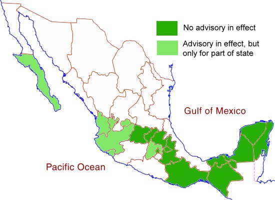
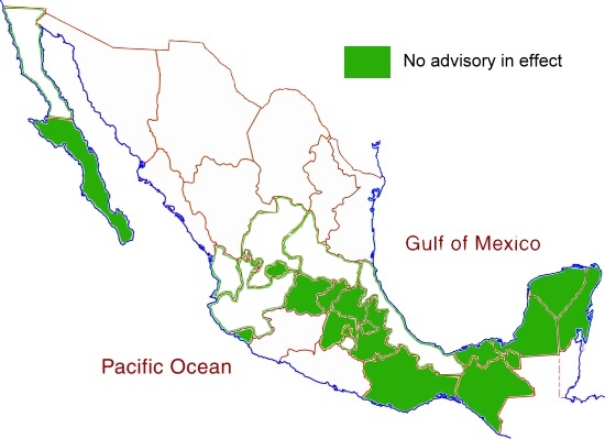
The states left white on the map below all have advisories in effect (as of mid-January 2015) for most or all of the state in question. For the states shaded light green, only small parts of the state have advisories in place, while no advisories are currently in place for those states shaded dark green.

US Travel Advisory Areas, December 2014

US Travel Advisory Areas, December 2014: All states, other than those colored dark green, have travel advisories in place for at least part of the state

The Canadian government offers its own travel warnings for Mexico:

The Canadian advisories apply to all those states left white on the map below. States shaded dark green have no travel advisory in effect so far as the Canadian government is concerned.

Canadian Travel Advisory, November 2014. No advisory in effect for states colored dark green.

Canadian Travel Advisory, November 2014. No advisory in effect for states colored dark green.

The most obvious difference between the maps is that the US State Department is relatively unconcerned about the states of Jalisco and Nayarit, while the Canadian authorities have included them in a regional advisory.

States shaded dark green on both maps are areas where the US State Department and the Canadian government have no serious concerns about travel safety. These states, where travel is considered safe, include Guanajuato (including the cities of Guanajuato and San Miguel de Allende), Querétaro (including Querétaro City), Hidalgo, Puebla (including Puebla City), Oaxaca (Oaxaca City, Puerto Escondido and Huatulco), Chiapas (Tuxtla Gutiérrez and San Cristóbal de las Casas), Tabasco, Campeche, Yucatán (Mérida) and Quintana Roo (Cancún, Riviera Maya).

As always, tourists visiting Mexico and traveling within Mexico are advised to be cautious about visiting rural areas (especially in states where travel warnings are in place), to check local sources such as web forums for updates on the latest conditions, and to avoid driving at night.

Safe travels! Enjoy your trip!

Related post

The spatial diffusion of Banamex branches across Mexico prior to 1960

 Other  Comments Off on The spatial diffusion of Banamex branches across Mexico prior to 1960
Jan 102015
 

This post looks at where branches of Banamex (Banco Nacional de México) were founded in the period prior to 1960. Banamex is one of the oldest banking institutions in Mexico. It is now a subsidiary of Citigroup, but remains the second largest bank in the country after BBVA Bancomer.

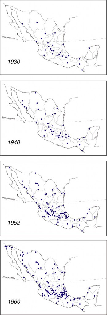
Diffusion of Banamex branches across Mexico prior to 1960

Diffusion of Banamex branches across Mexico prior to 1960. Click to enlarge

Banamex was formed on 2 June 1884 from the merger of Banco Nacional Mexicano and Banco Mercantil Mexicano, two banks that had only been operating for a couple of years. Shortly after its founding, Banamex had branches in Mexico City, Mérida, Veracruz, Puebla, Guanajuato, San Luis Potosí, and Guadalajara.

The maps to the left are based on Figure 8 of Las Regiones Geográficas en México by Claude Bataillon (8th edition, 1986, Siglo Veintiuno Editores).

Each dot represents the location of a branch of Banamex in the year shown. For simplicity’s sake, it is assumed that all branches present on any earlier map continued to exist through to 1960, and did not close or relocate in the interim.

The concept of spatial diffusion looks at the spread of an innovation, whether a new idea, technique, good, service or brand. The spatial diffusion of information or of the adoption of innovations is an important subset of spatial interactions. Looking at the spatial diffusion of a banking network offers lots of interesting insights into how Mexico’s economic geography has changed over the years.

There are three basic types of diffusion. The first is relocation diffusion where people travel or migrate and bring their cultural and technological practices with them. For example, modern studies in the genetics of corn (maize) have established that ancient Mexicans first domesticated corn in the Balsas valley. They then migrated both northwards and southwards, taking the practice of cultivating corn with them.

The second is contagious diffusion, which generally spreads from person to person and exhibits strong distance decay. An example is the spread of the Jehovah’s Witness faith in Mexico which required a considerable amount of face-to-face personal interaction. Many diseases also spread by contagious diffusion.

The third is hierarchical diffusion, which spreads across higher levels of a hierarchy and then down to lower levels. This is often how information from the top of an organization reaches those at the bottom. An example is the government’s 1970s family planning program that was first adopted in large cities, then smaller cities, and eventually penetrated into rural areas.

Combinations of these three types are also possible. One relatively recent example is the spread of the H1N1 influenza virus in early 2009. First reports were that it started in a rural village, probably in Oaxaca, and spread by contagious diffusion to others in the village. From there an infected person temporarily relocated to Mexico City where the flu again spread by contagious diffusion. From Mexico City, the top of the Mexican hierarchy, it spread down the hierarchy as carriers of the virus traveled to smaller Mexican cities and to other cities worldwide.

In the case of the diffusion of Banamex branches shown on the maps, the main type of diffusion involved is hierarchical. In this case, given that Banamex is a banking institution, the hierarchy reflects where most economic activity is taking place at the time. (There would be little point in placing a new branch in a location where little money was in circulation).

The 1930 distribution of Banamex branches looks to be quite scattered across the country, though Baja California and north-west Mexico have no branches and fall outside the network. By 1940 more additional branches have opened in the northern half of Mexico than the southern half, and the north-south economic divide that we have commented on in many previous posts is beginning to become apparent. Between 1940 and 1952 many new Banamex branches are added in central Mexico (this is the period when in-migration was turning Mexico City into a monster) and along the west coast, following the line of Highway 15 which runs from Guadalajara to the border with California. Overall, the north-south divide is now quite clear.

Between 1952 and 1960 additional branches open close to the US border, a branch finally reaches Baja California Sur (in La Paz) and the economic dominance of northern Mexico over southern Mexico is clearly established.

One of the most striking features, when comparing all four maps, is how the number of Banamex branches in southern and south-eastern Mexico (defined as the states of Chiapas, Tabasco, Campeche, Yucatán and Quintana Roo) barely changed between 1930 and 1960.

It would be interesting to update this example with similar maps for more recent years. Please contact us if you have access to suitable data or know where such data may be found.

Other posts related to the concept of diffusion:

Another instance of diffusion, of cholera in Mexico during the 1991-1996 epidemic, is mapped and discussed in chapter 18 of Geo-Mexico: the geography and dynamics of modern Mexico. Geo-Mexico also includes an analysis of the pattern of HIV-AIDS in Mexico, and of the significance of diabetes in Mexico.

The Mexican tradition of Three Kings Day

 Other  Comments Off on The Mexican tradition of Three Kings Day
Jan 062015
 

Unlike the USA and Canada, where gifts are usually exchanged on Christmas Day (25 December), the original tradition in Mexico over the Christmas season was to exchange presents on Three Kings Day (Día de los Reyes, 6 January). In the Christian calendar, 6 January marks the Feast of the Epiphany, the day when the magi arrived in Bethlehem with their gifts for the infant Jesus. In homage to this occasion, Mexican children would dutifully stuff the largest shoes (or box) they could find with straw, and leave them outside their bedroom door on the night of 5 January, in anticipation of finding new toys the following morning.

Rosca de Reyes

A typical family-sized Rosca de Reyes

Three Kings Day is still very much a family day throughout Mexico. In the late afternoon or early evening, it is traditional for the whole family to share a rosca. Roscas are ring-shaped loaves of sweet bread, sold to be eaten on special occasions. The roscas for Three Kings Day each contain a small muñeco (doll). These muñecos were originally ceramic, but are now more usually plastic. The recipient of the piece of rosca containing the muñeco has to throw a party on 2 February (Candlemas day, Día de la Candelaria) for all those present at the sharing of the rosca. It is customary to provide tamales to feed everyone gathering on Candlemas day.

Cristina Potters’ outstanding blog Mexico Cooks! includes a comprehensive account of the significance of the cuisine associated with Three Kings Day and Candlemas Day,

In the 20th century the Three Kings Day tradition in some regions of Mexico broke down in the face of the enormous consumer-oriented publicity from north of the border, which stressed Christmas (rather than Epiphany) gifts. Some especially greedy Mexican middle- and upper-class children claim that their parents and grandparents should not only preserve the old customs but also embrace the new version, and therefore hope to receive gifts on both days!

Nuevo León’s unusual shape

 Other  Comments Off on Nuevo León’s unusual shape
Jan 032015
 

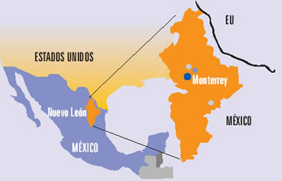
The northern state of Nuevo León is an industrial powerhouse, centered on Monterrey, Mexico’s third-largest city. The state’s shape on a map is unusual in more ways than one. The state has a long north-south axis and is very narrow from west to east. The strange indentation south of Monterrey is largely determined by relief. The peaks of the mountains on the Nuevo León side of that state boundary comprise a National Park, the Parque Nacional Cumbres de Monterrey.

Source: Universidad Autónoma de Nuevo León (UANL)

Source: Universidad Autónoma de Nuevo León (UANL)

Perhaps the strangest aspect of the shape of Nuevo León is the peculiar extension that forms the state’s north-eastern extremity (see map above). This small section of the state, about 15 km across, is sandwiched between the states of Coahuila and Tamaulipas, and extends to the Río Bravo and the U.S. border. The reason for this particular extension must date back a long time since it is clearly shown on this 1824 map of Mexico.

(Note that the shape of the neighboring state of Tamaulipas, with its lengthy extension north-west paralleling the US border, made much more sense in the early nineteenth century before the current international boundary was established).

While we’re not sure of the precise timing or reasons for the “neck” of land that gave Nuevo León access to the Río Bravo even before the current international boundary was fixed, it has certainly brought the state some benefit in recent decades in terms of economics and trade. Nuevo León is the smallest of the combined ten “border states” in the USA and Mexico.

A closer look at the Google Map image (above) of this area shows the border crossing of Laredo-Colombia across the Solidarity International bridge. Colombia is the name of the small grid-pattern town on the Mexican side, just west of the crossing.

Zooming in on the area of the crossing reveals the distinctive street pattern of a major border crossing, with extensive parking and loading areas.

The 371-meter-long (1216 ft) bridge has eight lanes for traffic and two walkways for pedestrians. It is one of four vehicular international bridges close to the city of Laredo, Texas. The community of Colombia and the international bridge were built to give Nuevo León its only international “port” for direct trade to and from the USA.

Related posts:

A Happy New Year to all our readers!

 Other  Comments Off on A Happy New Year to all our readers!
Jan 012015
 

We had no idea when we first published Geo-Mexico, the geography and dynamics of modern Mexico, and started this associated blog, how many readers we would reach.

Geo-Mexico-ThumbnailOn the one hand, very few U.S. or Canadian universities have courses devoted specifically to Mexico. There are quite a number of geography courses with titles such as “The Geography of Mexico, the Caribbean and Central America”, or “The Geography of Latin America”, but very few that focus mainly or solely on Mexico. This is unfortunate and means that most geography students graduating from USA universities will have only a partial knowledge, at best, of their southern neighbor. It also means that Geo-Mexico was not adopted by as many university courses as we might have hoped.

On the other hand, the book has been used in several courses that were not part of its target market, including courses in “The Politics of Mexico” and at least one International Affairs program. Equally, it has exceeded our expectations in providing a basic guide for non-specialists interested in getting a better knowledge of Mexico; the frequent feedback from readers has been overwhelmingly positive and gratifying. (Please keep it coming!)

The blog has proved to be very popular, and its audience continues to grow ~ don’t forget to recommend it to friends and colleagues. We welcome all comments and suggestions for future posts. We also welcome 400-800 word submissions (which will be published with your byline), but please contact us first.

Maps from Geo-Mexico have been included in many academic publications and a number of graduate theses. Publications that referred to the book, and/or blog, cover an amazing range of topics. A random sampling includes:

  • “Environmental risk, resilience and migration: implications for natural resource management and agriculture” in Environmental Research Letters  (2012)
  • “Texas and Mexico: Sharing a Legacy of Poverty and Neglected Tropical Diseases” in PLoS Neglected Tropical Diseases (2012)
  • “Zapatista Autonomy in Cartel Mexico: Preserving Smallholder Viability”, in Culture, Agriculture, Food and Environment (2011)
  • “NAFTA: The Mexican Economy, and Undocumented Migration” a research paper of Naval War College Newport, RI, Joint Military Operations Dept. (2011)
  • The Future of Entrepreneurship in Latin America (Palgrave Macmillan, 2012)
  • “Climate Change, Migration and Security, Best Practice Policy and Operational Options for Mexico”, an Interim Report from the Royal United Services Institute, Whitehall, London (2012)
  • “Vulnerability and Surviving Pattern of Elderly Migrants in Urban Mexico”, in Journal of Sociological Research (2012)
  • OECD Reviews of Risk Management Policies: Mexico 2013 Review of the Mexican National Civil Protection System (OECD 2013)

To all our readers, thanks for your support, and we wish you all a

Happy New Year! ¡Feliz año nuevo!