The important role of telenovelas and historietas as forms of communication in Mexico

 Excerpts from Geo-Mexico  Comments Off on The important role of telenovelas and historietas as forms of communication in Mexico
Dec 312012
 

The highest rating programs on TV are televised novels, telenovelas. A telenovela is a limited‑run television serial melodrama, somewhat like a soap opera but normally lasting less than a year, and where the eventual ending has already been scripted.

image of los ricos tambien lloranThe first global telenovela was Los ricos también lloran (“The rich cry too”), originally shown in 1979. Telenovelas are now a $200 million market. Some critics claim they are effective promoters of social change, others deride them as being nothing more than mass escapism. Whichever view is more accurate, their portrayals reflect society’s values and institutions.

Advocates of telenovelas point to their role in challenging some traditional Mexican media taboos by including story lines about urban violence, racism, homosexuality, birth control, physical handicaps, political corruption, immigration and drug smuggling. Early telenovelas tended to be shallow romantic tales. The form subsequently evolved to include social commentaries and historical romances, some applauded for their attention to historical detail. Some were used for attempts at social engineering. An early government-sponsored telenovela promoted adult literacy programs. Several others openly advocated family planning and have been credited with contributing to Mexico’s dramatic decline in fertility rate. Other telenovelas have targeted younger audiences, focusing on issues connected to pop music, sex and drugs.

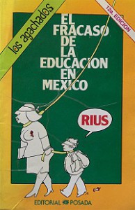
Rius historieta: The failure of education in Mexico

Rius historieta: The failure of education in Mexico

Besides the shallowness of the plot lines in most telenovelas, the other common criticism is that their stars are almost always white-skinned, blue-eyed blondes. Sadly, all too often, actors with indigenous looks are relegated to roles portraying menial workers such as home help or janitors.

Telenovelas have been extraordinarily successful commercially. They have become immensely popular not only in Latin America and among the US Hispanic population but also in more than 100 other countries, mainly in Eastern Europe and Asia.

In print media, a similar role to the telenovela has been played by historietas (comic books), the best of which have tackled all manner of social, political and environmental issues well before such topics made the main-stream press. Historietas helped educate millions of Mexicans and were also a commercial success. Their circulation peaked in the 1980s but has since declined due to competition from television and, more recently, the internet. The most influential creator of historietas is the cartoonist and writer Eduardo del Río (Rius) whose work earned him a 1991 United Nations Environment Programme prize.

Related posts:
Which company produces the most motor vehicles in Mexico?

 Updates to Geo-Mexico  Comments Off on Which company produces the most motor vehicles in Mexico?
Dec 292012
 

Back in 2006, General Motors (GM) was the clear leader in production with 493,841 units (just over 25% of the national total). Nissan was second with 411,236 units (21%). These were followed by Volkswagen (VW) – 339,183; Ford – 329,993 and Chrysler – 307,344. The newcomers, Toyota and Honda trailed way behind with 33,835 and 24,297 units, respectively.

By 2011 the picture had changed considerably. All the manufacturers suffered major losses in 2009 as a result of the Great Recession, but all have recovered, some better than others. Between 2006 and 2011, Nissan increased total production by 48%. In 2011, Nissan led all producers with 607,087 units for almost 24% of the national total.

Nissan easily surpassed GM which increased 2006 to 2011 by only 10% for a total of 544,202 units. VW increased by an impressive 50% to 510,041 units. Ford nearly kept pace with an increase of 40% to 462,462 units. Chrysler with merged with Fiat matched GM with an increase of only 10% up to 338,772 vehicles. Toyota upped production by a very significant 47% to 49,596 units. Honda did even better, increasing its production by a whopping 87% to 45,390 units.

Final data are not yet available to determine which companies led production in 2012. Overall production was expected to rise by over 20% in 2012 and perhaps even faster in future years judging by the amount auto companies are currently investing in Mexico. Obviously, production levels in 2013 and beyond will be closely tied to demand which is linked to overall economic growth. Judging from the investment amounts announced so far, it appears that Nissan will retain its lead in total production, with VW and Ford perhaps challenging GM for second place.

Related posts:

Mexico’s sixteenth century Geographic Accounts: the example of Jiquilpan, Michoacán

 Books and resources  Comments Off on Mexico’s sixteenth century Geographic Accounts: the example of Jiquilpan, Michoacán
Dec 272012
 

In a previous post, we introduced the Geographic Accounts, a rich source of information about Mexico’s sixteenth century geography. The style and substance of a typical Geographic Account can be judged by extracts from the response (dated 1579) relating to Jiquilpan (then written as Xiquilpan), in what is today the western part of the state of Michoacán in western Mexico. In the following (translated) extracts, square brackets enclose editorial comments, not found in the original.

Xiquilpan is in temperate land… A river, which never dries up, passes the village; it carries very little water in summer. In winter, it often rises so much that it can not be crossed. Less than one league from this village towards the north is a lake called Chapala, which is forty leagues around. A lot of white fish and catfish, and another kind of small fish, are caught in it. A large, very full, river, called Chicnahuatengo, enters this lake. [One league is about the distance that could be walked in an hour, from 4.18 kilometers to 6.687 kilometers, depending on the terrain.]

The village is settled on flat and very level ground, without hills…. It is very fertile land. It produces a lot of corn, chile, beans and other seeds that the natives sow. The native fruits are guamúchiles, avocados and guavas. There are lots of figs, pomegranates, quince trees and grapes. It is land where anything that is sown grows….

Xilquilpan has very few Indians: there could be in it about one hundred tributary Indians. They say that before the land was won, there were one thousand two hundred people. After the lands had been won, their number has been diminishing as a result of the many diseases that have occurred. In particular, in [15]76, there was a great plague in this village, common throughout New Spain, from which a large number of people died….

There is a wild plant in this village which cures those who are crippled. It has leaves like a lettuce and is so hot that the part where the root is put burns naturally, like a fire. There is another [plant], which has a root similar to camote: it is a preventative for everything. They cure with these herbs and with others that the natives know….

This village was subject, when it was heathen, to Cazonzi, king of Mechuacan, who ruled over and was in charge of it; on his behalf, he put an Indian chief called Noxti in this village in order to govern and look after them. At that time, they gave corn and chile as tribute to the said Cazonci, which was received by Noxti and sent to Pátzcuaro. At that time, they idolized the Devil, so that he would help them when they went to fight other Indians from neighboring villages. They say that when they caught an Indian, they carried him to a hill next to the village, and there they sacrificed him and offered him to the Devil, and they cut him open and removed his heart and those who had made the sacrifice ate it…

They wore some shawls of joined together sisal, like jackets, without anything else, and cotton breeches, different to what they now wear. Their food was tortillas, tamales, beans, and other wild herbs that they called quiletes [meaning edible herbs or greens in general] and they drank white maguey wine called tlachiquil [unfermented pulque]. They say that they used to live longer than now, and that the reason for this could not be ascertained…

In this village and its surrounding areas, grow pears, figs, pomegranates, grapes, peaches, quinces, nuts, apples, all Castillian [Spanish] fruits. Native [plants] are avocados, sweet canes, guavas, capulines (which are local cherries), squash, chile, tomatoes and a lot of corn. It is land where it does not snow, formerly or now. They raise many birds, both native and from Spain. They grow cabbages, lettuce, onions, radishes, blites, and every kind of vegetable from Spain. Wheat and barley grow in this village.

The animals that there are in the village are wolves, which breed in the swamps that surround some reed beds, a quarter of a league from the village. More than eighty thousand sheep come from other parts to pasture seasonally on the edge of this village each year; it is very good land for them and they fatten very well, since there are some saltpeter deposits in the marsh.

There are no salt beds in this village; the natives supply themselves with salt from Colima, twenty leagues from this village, and from the province called Avalos fifteen leagues away…

Xiquilpan has a monastery of monks of the Order of San Francisco; it has two clerics, one is the guardian. The founder was Brother Juan de San Miguel, and it was founded about forty years ago for all the clerics that were in this province of Mechuacan. The village has a hospital, where the sick are treated, which was begun thirty years ago and founded by a cleric called Brother Alonso de Pineda of the Order of San Francisco. It receives no rents: it is sustained only by the poor, from the alms they beg from the natives.

As can be seen, the Geographic Accounts are of immense value in reconstructing the past history of Mexico. The detail in them is often quite astonishing. However, as René Acuña emphasizes, while the Accounts provide invaluable information about local cultures, including that of the indigenous peoples, they should never be considered completely reliable. They were not eye-witness accounts and often relied on hearsay and on the possibly dubious interpretations made by a relatively limited number of respondents.

Source:

Several transcriptions of the Relaciones geográficas have been published in Spanish. The version used in preparing this article (translations by the author) is Acuña, R (ed) 1987 Relaciones geográficas del siglo XVI: Michoacán. Edición de René Acuña. Volume 9 of Relaciones geográficas del siglo XVI. Mexico City: Universidad Nacional Autónoma de México.

Note: This post is based on an article first published on MexConnect.com

Related posts:

Two examples of bird re-introduction programs in Mexico

 Mexico's geography in the Press  Comments Off on Two examples of bird re-introduction programs in Mexico
Dec 222012
 

Assuming that the world did not come to an end yesterday, Geo-Mexico would like to convey best wishes to everyone for the entire duration of the next Long Count Maya calendar cycle, which runs until sometime in 2406. This may allow sufficient time for some real progress to be made in environmental stewardship.

Today’s post looks at two ornithological conservation projects that have made significant advances in 2012. The first is in Maya territory in south-east Mexico, where biologists are trying to stave off the extinction of the colorful Scarlet Macaw, and extend its current range. Researchers believe that between 250 and 400 of the birds now remain in the wild, almost all of them in the area straddling the borders between Mexico, Guatemala and Belize.

Birds raised in the Xcaret Center for the breeding of macaws, located in the state of Quintana Roo, are being gradually prepared for being set free in Aluxes Park, an ecological reserve on the edge of the natural forest in Palenque, in the state of Chiapas. The plan is to release as many as 250 birds over the next five years. The natural range of the Scarlet Macaw, prior to deforestation, habitat loss and wildlife trafficking, once extended all the way along Mexico’s Gulf coast, from Tamaulipas to Campeche.

At the other end of the country, a decade-old multi-institutional project (government, academic and NGO) aims to reintroduce the California Condor into Baja California state. There are believed to be about 30 California Condors now flying free in the Sierra de San Pedro Martir, following the release of six condors there earlier this year.

California Condor

California Condor in flight. Credit: Friends of the California Condors

Specialists say the project has almost reached the point at which the birds are likely to reproduce successfully in the wild. Since 2008, 10 nesting sites have been located. Condors nest in caves making it difficult and time-consuming to locate nests, even when the birds are tagged with transmitting devices. Among the threats to the success of the program is the incidence of lead poisoning in condors resulting from them swallowing bullets left in animal carcasses killed, and then abandoned, by hunters.

Related posts:

The “Geographic Accounts”: Mexico’s sixteenth century “Domesday Book”

 Books and resources  Comments Off on The “Geographic Accounts”: Mexico’s sixteenth century “Domesday Book”
Dec 132012
 

Mexico’s equivalent of the Domesday Book was compiled in the sixteenth century.

Conquerors often have very little idea of precisely what they have acquired until their victory is assured. In many cases, one of their first post-conquest steps, therefore, is to undertake a comprehensive survey of everything of value, or potential value.

For instance, in 1086, William the Conqueror ordered a survey of his newly acquired England, the results of which were compiled into the Domesday Book. The decision to send out his assessors to every corner of the land was made at his Christmas Court in 1085. As a belated Christmas present to himself, William wanted to know “what or how much each landholder had, in land or livestock, and how much money it was worth”, so that he could tax it accordingly.

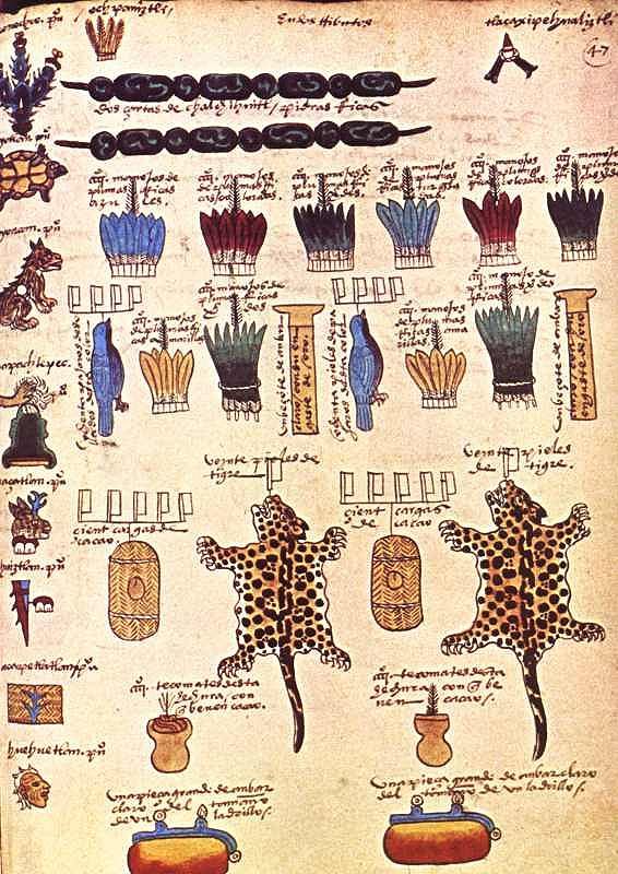
Though less comprehensive, a pictorial record of the wealth of Mexico already existed prior to the Spanish conquest. The Mexica people had gradually established an empire (the Aztec Empire) stretching from the Gulf coast to the Pacific. In order to administer the tributes due from each part of the empire, they recorded the requisite payments of feathers, animals, minerals and food, on bark paper codices. Some of these documents still survive, though most were destroyed by the Spanish. The image below is taken from the Codex Mendoza, which was created shortly after the conquest as a record of Aztec life, including the tributes payable by various villages and towns.

Tribute page from the Codex Mendoza

Tribute page from the Codex Mendoza

In this case, the tribute includes:

  • 2 strings of beads of jadeite, a green semi-precious stone
  • a total of 4000 handfuls of colored feathers
  • 160 skins of the bird with a blue plumage
  • 2 labrets (lip piercings) of amber encased in gold
  • 40 skins of jaguar
  • 200 loads of cacao beans, the main ingredient of chocolate
  • 800 tecomates (cups for drinking chocolate)
  • 2 slabs of clear amber, each approximately the size of a brick

Such tribute lists were of little interest to the Spanish when they arrived. Some of the items held in high esteem by the Aztecs were deemed worthless by the conquerors. Other items, such as silver, of little or no consequence to the Aztecs, were highly prized by the Spaniards.

Back in Spain, the Spanish Court was determined to acquire accurate information about everything being encountered in New Spain. This led to a series of censuses and accounts, including the Relaciones geográficas (Geographic Accounts), the earliest version of which dates back to the late sixteenth century.

In 1569, shortly after Juan de Ovando y Godoy was named Visitor of the Council of the Indies, he sent a questionnaire containing 37 questions to the New World. Another questionnaire, with about 200 questions, was sent in 1570. A few years later, perhaps in an effort to elicit more responses from the provinces, Ovando y Godoy’s former secretary and successor Juan López de Velasco reduced the number of questions to 50. These 50 questions, sent to New Spain in 1577, became the basis for the Geographic Accounts.

The authorities in each administrative center were instructed to call a meeting of the “Spaniards and other natives in the district”, to find out everything they could about the area’s geography, people and history.

Of the 191 known responses to the 1577 questionnaire, 167 have survived in archives to the present day. Most of the original responses are housed in Spain, in either the Archivo General de las Indias (Seville) or the Real Academia de la Historia (Madrid). A further 43 of them form part of the Benson Latin American Collection in the University of Texas library in Austin. The library’s webpage about the Relaciones geográficas has several links to images of sample pages and maps.

A future post will look at the content of a typical example of a “Geographic Account”.

Source:

Several transcriptions of the Relaciones geográficas have been published in Spanish. The version used in preparing this article is Acuña, R (ed) 1987 Relaciones geográficas del siglo XVI: Michoacán. Edición de René Acuña. Volume 9 of Relaciones geográficas del siglo XVI. Mexico City: Universidad Nacional Autónoma de México.

Note: This post is based on an article first published on MexConnect.com

Related posts:

Dec 102012
 

Geographic Travels, one of my very favorite Geography blogs, recently posted a photo of a Mexican Christmas Tree, accompanied by a short history claiming that the Christmas tree was first introduced into northern Mexico by German industrialists and others.

That may be a popular notion, but the true history of Christmas trees in Mexico is far more interesting!

According to Historia del árbol de Navidad en México by Hector de Mauleón, prior to 1870, no writers describe the use of Christmas trees in Mexico. By 1890, however, Mexican author Manuel Gutiérrez Nájera (1859-1895) includes the Christmas tree in an inventory of Christmas customs writing that, “¡Tristes aquellos que no tienen un árbol de Noel!” (“Sad are those who do not have a Christmas Tree!”). At that time, small candles were apparently used to illuminate the tree.

Historians, including Teresa E. Rohde (1933-1992), generally agree that the Christmas tree was first brought to Mexico during the French Intervention by none other than Emperor Maximilian, whose execution in 1867 brought an end to this unfortunate episode in Mexico’s nineteenth century history. At some point during their three years in Mexico, Maximilian and his wife Carlota imported a Christmas tree from Europe and installed it in Chapultepec Castle, their palatial home. The tree impressed at least some of Mexico’s wealthy families, who began to install their own trees at Christmas time.

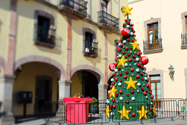
Artificial Christmas Tree with Coca-Cola decorations in Querétaro.

Artificial Christmas Tree with Coca-Cola decorations in Querétaro. Photo: http://burrohall.blogspot.ca/

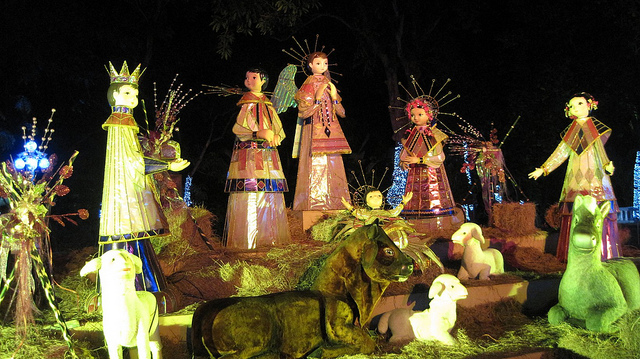
Within a few years, the Christmas tree had become a tradition in many homes and had begun to replace the elaborate traditional nativity scenes (nacimientos).

In 1878, General Miguel Negrete, who had fought against the French Intervention, decided to have a Christmas tree in his home. According to some sources, he may have brought the idea back from the USA, independently of the earlier European introduction. His tree garnered considerable press attention. It was decorated with 250 toys. As each of his guests arrived at the house, they were given a number, and later took turns to select a gift from the tree, according to one journalist’s contemporary press account.

Despite the popularity of Christmas trees in Mexico, some nationalists continue to decry the practice, considering them a cultural invasion that continues to threaten the much older tradition of nacimientos.

Modern Mexican Nacimiento. Photo: Ariaski (Flickr);

Modern Mexican Nacimiento. Photo: Ariaski (Flickr); creative commons license

Christmas trees are a good historical example of cultural invasion, but at what point (as Hector de Mauleón asks) does a new custom become a tradition? After 150 years, can we now agree that Christmas trees have been assimilated into Mexican culture? Or do we need to wait another 150 years?

Wherever you may be, and real tree or not, warmest Mexican seasonal greetings to all!

In an interesting follow-up post, Geographic Travels considers the possible “Layers of Geopolitical Myths” behind the introduction of Christmas trees into Mexico: The Christmas Tree in Mexico: Layers of Geopolitical Myths?

Related posts:

Durango gets its first Magic Town: Mapimí, along with the Ojuela suspension bridge

 Mexico's geography in the Press  Comments Off on Durango gets its first Magic Town: Mapimí, along with the Ojuela suspension bridge
Dec 082012
 

The state of Durango state finally has its first Magic Town. The small and historic town of Mapimí served various local mines, including San Vicente, Socavón, Sta. Rita, Sta. María, El Carmen, La Soledad, and the presumably traitorous Judas.

The indigenous Tepehuan Indians called this place “the rock on the hill” and repeatedly thwarted the attempts of Jesuit missionaries to found a town here, but the thirst for gold won in the end. It is rumored that gold was even found under the town’s streets. A small museum houses mementos and photos from the old days showing just how prosperous this mining town once was. One handbook to gem collecting in Mexico describes Mapimí as the “mineral collector’s capital of Mexico”. This is the place for the geologist in the group to find plenty of inexpensive agates, selenite crystals, calcite and other minerals.

Like seemingly every town in this region of Mexico, Mapimí boasts that both Miguel Hidalgo, the Father of Mexican Independence, and Benito Juárez, the President of Indian blood, passed by in the nineteenth century. Juárez even stayed overnight.

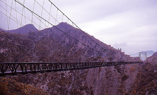
Ojuela Suspension Bridge

Ojuela Suspension Bridge. Photo: Tony Burton; all rights reserved

Access to one of the local mining areas, about 10 km outside the town is via the Ojuela suspension bridge, a masterpiece of engineering. Ruined stone houses on the hillsides tell of Ojuela’s former wealth. Ore was first discovered here in 1598. By 1777, seven haciendas de beneficio (enrichment plants) served thirteen different mines. In 1848, the Spanish mine owners gave up their struggle to make the mines pay and a Mexican company took over. In 1892 they decided to attack the hillside opposite Ojuela. To shortcut the approach, engineer Santiago Minguin spanned the gorge with a 315-meter-long suspension bridge, said by some to be the third longest in Latin America.

The mine’s production peaked just after the Mexican Revolution. Between 1922 and 1925, 687 kilograms of gold and 99,820 kilos of silver were extracted, alongside more than 51 million kilos of lead and a million kilos of copper. At that time, some 3000 miners celebrated every evening in the bars of Ojuela, now completely abandoned to the elements.

The bridge, restored for its centenary, is a worthy contribution to tourism in Durango state. One and a half meters wide, it sways and bounces in the breeze, probably scaring mums and dads into silent concentration faster than their excited children! But the local miners and their mineral-laden donkeys rattle across the planks as if it were a highway. Once across the bridge, old timers will take you on a one kilometer walk along mine galleries (unlit except for hand-held miners’ lamps) which completely traverse the mountain to emerge into daylight on the far side.

Not far from Mapimí is the internationally-famous “Zone of Silence”, the Mapimí Biosphere Reserve, the claimed merits of which are much discussed.

Mapimí is a very worthy addition to the Magic Towns list. In a future post, we will look at the merits of  six more towns added to the list in the last days of the previous federal administration.

Related posts:

The spatial distribution of Mexico’s GDP

 Other  Comments Off on The spatial distribution of Mexico’s GDP
Dec 062012
 

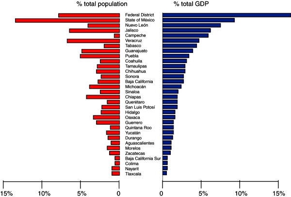
Mexico’s National Statistics Agency recently released a breakdown of GDP by state for 2011. The data allow for an analysis of the spatial distribution of Mexico’s GDP. The graph below shows each state’s contribution to GDP (blue bars) and their share of Mexico’s total population (red bars):

Population & GDP by state, 2011

Population & GDP by state, 2011. Data: INEGI. Credit: Tony Burton / Geo-Mexico; all rights reserved

In general, Mexico’s larger states (in terms of population) contribute more towards national GDP than its smaller states. Equally, even after population is taken into account, it is clear that some states contribute far more than others to Mexico’s GDP. The states of Campeche and  Tabasco both stand out as contributing far more than their fair share towards national GDP; this is on account of their oil and gas reserves. The Federal District, Nuevo León, Quintana Roo and Querétaro also outperform in terms of economic output. On the other hand, Michoacán, Chiapas, Oaxaca and Guerrero all stand out for contributing less to Mexico’s GDP than the size of their population would suggest.

The economic disparities revealed by the data are closely matched by other indicators of economic disparity such as differences in poverty rates and the distribution of the wealthiest households. For more about these topics, start with the related posts listed below.

Related posts:

Pemex boosts reserves and reduces its emissions

 Mexico's geography in the Press, Updates to Geo-Mexico  Comments Off on Pemex boosts reserves and reduces its emissions
Dec 032012
 

It may come as something of a surprise to many observers, but during 2012, Mexico’s state-owned oil company Pemex (Petróleos Mexicanos) has received several well-deserved plaudits for its efforts to slash the emissions associated with oil and gas exploration, reserves and production.

For the fifth consecutive year, the Global Reporting Initiative awarded Pemex the highest possible rating for social responsibility. The company also received excellent ratings for sustainable asset management. During 2011, Pemex’s proven reserves increased 1.1%, while the petro-giant cut total emissions by 17.3% compared to the previous year. Crude oil output averaged 2.55 million barrels a day in 2011. Carbon dioxide emissions were down 8.8% in 2011, while sulfur oxides have now fallen more than 50% since 2007.

Meanwhile, the production division of Pemex has been praised by World Bank experts for having reduced burn-off from its giant Cantarell gas field from 31% in 2008 to 3% in July 2011. Pemex has invested more than 1.6 billion dollars in the Cantarell field over the last six years in order to improve efficiency, with the installation of compressors, flow separation devices and re-injection technology. In the past three years, it has reduced total emissions, including greenhouse gases, from 13.6 billion cubic meters a year to 2.1 billion. Pemex is well on track to beat its target of 99% efficiency in gas recovery by 2014.

Crude oil production has risen steadily in 2012. For example, in August 2012, Pemex produced 2.56 million barrels of oil a day (b/d), its highest output since May 2011. The Chicontepec field in Veracruz is doing especially well. Its single best-performing well, named Presidente Alemán 1565, uses innovative technology, including three dimensional seismic mapping and horizontal drilling, to yield as much as the combined output of 28 other wells in the region.

Mexico’s current 3P (proven, probable, possible) reserves are also on the rise, and currently total 43 billion barrels of crude oil equivalent. After years of depletion, Pemex is now adding more oil and gas each year to its reserves than it is extracting. The oil giant recently announced a huge deep water, light crude discovery in the Gulf of Mexico, off the coast of Tamaulipas, its first major find in the Perdido Fold Belt, where the total 3P reserves could be as high as 10 billion barrels. The Trión-1 well, drilled to a total depth of 4,500 meters (14,800 feet), is 40 km (25 miles) inside Mexico’s territorial waters and is expected to yield up to 400 million barrels of high quality crude.

Pemex also recently reported the largest land-based discovery of oil for about a decade. The Navegante-1 well, drilled in the South-East Basins 20 km from Villahermosa (Tabasco) found light crude oil with an APR gravity of 45 degrees, at a depth of 6800 meters. The field is 87 square kilometers in area and has estimated 3P reserves of about 300 million barrels of crude oil equivalent.

Related posts:


Decision about GM corn in Mexico postponed until 2013

 Mexico's geography in the Press  Comments Off on Decision about GM corn in Mexico postponed until 2013
Dec 012012
 

Mexico’s new president Enrique Peña Nieto took office earlier today. His single, six-year term will end in 2018. The change of government means that a final decision about the commercial planting of genetically modified (GM) corn in Mexico has been postponed until sometime early next year.

As we have seen in several previous posts, GM corn is a hotly disputed topic in Mexico.

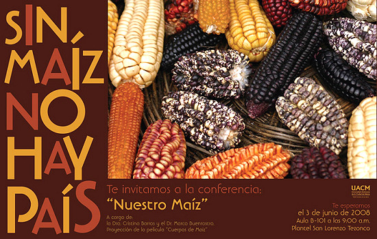
Corn poster

“Without corn there is no nation” (Conference poster, Autonomous University of Chihuahua)

Proponents argue that GM corn will lead to higher yields and reduce losses from pests and diseases. In their view, the commercial planting of GM corn in Mexico is inevitable and will help Mexico “catch up” with Brazil and Argentina, where GM crops are already being grown.  Opponents argue that GM corn will inevitably reduce the genetic diversity of corn, meaning that corn will have less resilience in future to unexpected (and unpredicted) changes (climate, pests, soil conditions, etc). They also argue that GM corn will make corn growers even more dependent on commercial seed producers.

US farmers have found that GM corn lives up to its advertised higher yields and disease resistance. Farmers organizations in northern Mexico have come out in public support of this view, though many farmers in the center and south of the country remain vehemently opposed to GM corn on the basis that cross-contamination would deplete the plants’ gene pool, and possibly lead to the eventual extinction of traditional corn varieties.

Mexico was the world’s 6th largest grain producer in 2010, but fell to 8th spot in 2011. In just 20 years, Mexico has gone from a nation that needed to import less than 400,000 metric tons of corn a year in order to satisfy its domestic market to one where, in the 2012-12 season, it will need to import about 11,000,000 tons. Mexico’s corn imports, mainly of yellow corn for animal feed, are expected to rise to 15,000,000 tons by 2020. Corn prices are also likely to rise since an increasing portion of the annual US corn crop is  destined for biofuel production rather than human consumption.

Mexico currently produces about 22 million metric tons of corn (mainly white corn for human consumption) from 7.2 million hectares nationwide. According to press reports, there are five applications for planting GM corn on a commercial scale. The total area involved is 2.5 million hectares (6.2 million acres).

  • The transnational seed firm Monsanto has two proposals, each for 700,000 hectares, in Sinaloa, Mexico’s leading corn-producing state
  • Pioneer Hi-Bred International (currently owned by DuPont) has submitted three applications, each for around 350,000 hectares, in Tamaulipas
  • Dow Agrosciences (a unit of Dow Chemical) has applied to grow GM corn on 40,000 hectares, also in Tamaulipas.

It is widely believed that the new government will approve the large-scale trials of GM corn that the companies are requesting. It is likely, however, that GM corn will be confined to certain areas of Mexico only, with other areas designated “centers of origin” for corn where cultivation of GM seeds would not be permitted.

Among the most vocal opponents to the plans for GM corn is the ETC (Action Group on Erosion, Technology and Concentration) group. They set out their views in a multi-page news release. Verónica Villa, of ETC’s Mexico Office, says that,

“If Mexico’s government allows this crime of historic significance to happen, GMOs will soon be in the food of the entire Mexican population, and genetic contamination of Mexican peasant varieties will be inevitable. We are talking about damaging more than 7,000 years of indigenous and peasant work that created maize – one of the world’s three most widely eaten crops.”

Geo-Mexico will continue to report on this issue as it develops in coming months.

Want to learn more? This short open letter from the Unión de Científicos Comprometidos con la Sociedad (Union of Socially-Committed Scientists)  ~ Call to action vs the planting of GMO corn in open field situations in Mexico ~ has an extensive bibliography.

Related posts: