Which tectonic plates affect Mexico?

 Excerpts from Geo-Mexico  Comments Off on Which tectonic plates affect Mexico?
Apr 022012
 

The theory of plate tectonics suggests that the earth’s crust or lithosphere is from 5 to 65 km (3 to 40 mi) thick and divided into about a dozen large tectonic plates, tabular blocks that drift across the Earth in different directions and at various speeds (up to a few centimeters or inches per year), probably as a result of thermal convection currents in the Earth’s molten mantle. Most plates consist of a combination of both ocean floor and continent, though some are entirely ocean floor.

Each tectonic plate is moving relative to other plates. The movements are not independent because the plates smash into and scrape against one another. Areas in the center of tectonic plates, far from the boundaries, have relatively little seismic activity, but the boundaries between plates are seismically very active, creating earthquakes and volcanoes. The level of seismic activity depends on the relative speed and direction of the plates at the boundary.

There are three distinct kinds of boundaries between plates. At divergent boundaries, along mid-ocean ridges, plates are being steadily pushed apart, with new crust being added by volcanic activity to the rear of each plate as it moves. At convergent boundaries, plates collide and parts of the plates either buckle or fracture or are subducted back down into the molten mantle. The third kind of boundary is where plates are neither created nor destroyed but are moving side by side. The resulting friction as they rub against each other can produce large earthquakes.

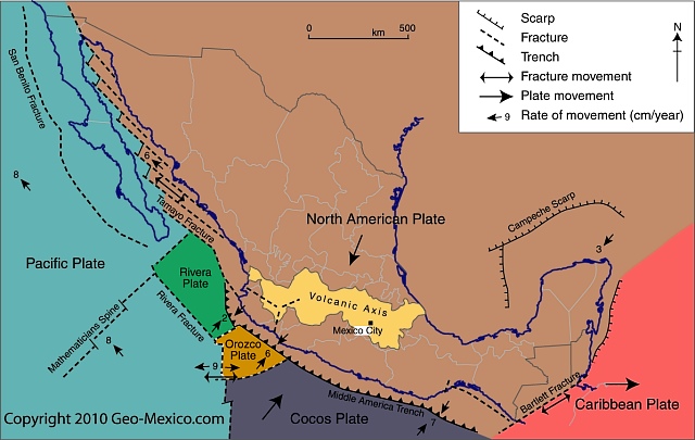
Almost all of Mexico sits atop the south-west corner of the massive North American plate (see map). Immediately to the south is the much smaller Caribbean plate. The North American plate extends westwards from the Mid-Atlantic Ridge, which runs through Iceland and down the middle of the Atlantic Ocean, to the western edge of North America. In a north-south direction, it extends from close to the North Pole as far south as the Caribbean.

Mexico's position in relation to tectonic plates

Mexico's position in relation to tectonic plates.Map: Geo-Mexico.com; all rights reserved

While most of Mexico rests on the North American plate, it is also influenced by several other plates.

The Baja California Peninsula is on the gigantic Pacific plate, which is moving northwest and under the North American plate. The intersection of these plates under the Gulf of California causes parallel faults which are part of the famous San Andreas Fault system. Thus, the Gulf of California is an area of heavy seismic activity.

The small Rivera plate, between Puerto Vallarta and the southern tip of Baja California, is moving in a southeasterly direction and rubbing against the Pacific plate; it, too, is moving under the North American plate.

The Cocos plate and tiny Orozco plate are ocean crust plates located off the south coast of Mexico. The collision of the Cocos plate and the North American plate has had several far-reaching consequences, including both the disastrous 1985 earthquakes that caused such severe loss of life and damage in Mexico City and the much more recent 2012 earthquake that, fortunately, was far less destructive.

Related posts:
The geography of wildfires in Mexico: the disastrous wildfire season of 2011

 Other  Comments Off on The geography of wildfires in Mexico: the disastrous wildfire season of 2011
Jan 212012
 

In the past 20 years, wildfires have destroyed 47,000 square kilometers (18,000 sq. mi) in Mexico, equivalent to five times the area of all sections of Mexico City’s Chapultepec Park, the largest urban park in Latin America. The average fire in Mexico affects 32 hectares (80 acres); this figure has not changed significantly in recent years, even though the incidence of fires has increased somewhat due to a combination of climate change and an increase in the number of people living on the margins of forested areas. The National Forestry Commission (Conafor) says that 99% of Mexico’s forest fires are caused by human error, and only 1% are due to natural causes such as lightning strikes.

It generally takes about 30 years to rehabilitate forest areas ravaged by fire, with reforestation costing up to $2400/ha.

Wildfires are not entirely bad. For example, they help regenerate grassland areas, especially, with fresh young plants. On the other hand, in addition to protecting the existing vegetation, stopping wildfires when they occur helps to preserve soil structure and prevents additional emissions of CO2 from the burning of more plant material. At a national level, it is estimated that fires result in the erosion of 86 million metric tons of soil a year.

In a 2009 study, Conafor used 17 variables to identify the areas of the county with the highest risk of wildfires. Three broad areas accounted for the 900,000 square kilometers identified as having either a “medium” or “high risk” for wildfires:

  • i. Yucatán Peninsula, Chiapas, Oaxaca and Guerrero
  • ii. Central Mexico – Veracruz, Tlaxcala, Puebla, México, Michoacán, Jalisco and the Federal District. This area has more fires than any other because local populations often use fire to clear fields before planting.
  • iii. Baja California. This is the only area where the main fire season is in summer, from March to November. This is the rainy season in the remainder of Mexico, where the fire season corresponds with the winter dry season.

The first half of 2011 was an especially bad period for wildfires in Mexico, the worst for at least 30 years.

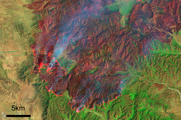
Coahuila wildfire, April 9, 2011 (Earth Observatory, Landsat-5)

Coahuila wildfire, April 9, 2011 (Earth Observatory, Landsat-5)

During the first half of 2011, serious wildfires devastated several areas of northern Mexico, with the states of Coahuila and Nuevo León being hardest hit. Other states badly affected included Durango, Chihuahua, Quintana Roo, Oaxaca, Puebla and Guerrero. More than 7,800 fires occurred, severely damaging a total area of 4100 square kilometers. 30 of Mexico’s 32 states were affected; only Tabasco and Baja California Sur escaped unscathed.

Conafor’s annual fire-fighting budget for the entire country is only 650 million pesos ($50 million dollars); the average annual area damaged by wildfires is only 2600 square kilometers, of which 500 square kilometers are forest. At the height of the 2011 fire season, more than 60 new fires were being reported each day, according to Conafor.

Coahuila

In the state of Coahuila, fires damaged 250 square kilometers in four weeks. It is believed that 50% of these fires were due to farmers losing control of deliberate burns. Farmers are supposed to have an adequate fire-suppression plan in place before setting a deliberate burn, but in practice this requirement is not enforced.

The main locations were La Sabina and El Bonito. Authorities were very slow to respond. Diana Doan-Crider, a wildlife biologist at Texas A&M University, has spent the past 25 years studying the Mexican black bear in the Serranía del Burro in Coahuila, an ecological corridor that runs parallel to the Eastern Sierra Madre. The area includes a large population of Mexican black bears. Doan-Crider claims that authorities completely ignored the first warnings and that their eventual response (two weeks after the first fires started) lacked adequate coordination. Many mother bears and their young cubs perished in the fires.

Firefighters in Coahuila had to cope with a spectacular but terrifying fire whorl or fire tornado

Nuevo León

In the neighboring state of Nuevo León, large swathes of ranching land were ravaged by fire. One rancher who lost more than 10,000 ha of cattleland was equally critical of the slow response time of firefighters who took more than two weeks to appear on the scene, by which time the fires had taken hold.

David Garza Lagüera had converted his 14,000 ha ranch into the Cumbres de Monterrey National Park, one of the key areas of bear habitat. The largest pines on his land were more than 150 years old. All were totally destroyed.

The worst damage was in Galeana, Montemorelos, Zaragoza, Aramberri and Mina. The area burned in Nuevo León in May 2011 was almost ten times the total area affected in the state for the whole of 2010.

Why was the 2011 fire season so bad?

To quote the Earth Observatory, “Lack of winter rain and frost left the plants dry and prone to fire. On top of that, the area has not burned for more than 20 years, during which time fuel built up. Thunderstorms and steady strong winds with gusts up to 110 km/h (70 mph) completed the formula for a dangerous, fast-moving wildfire.”

Ironically, the passage of Hurricane Alex in July 2010, which brought 1500 mm (60″) of rain to the Serranía del Burro, actually worsened the fire damage the following year. The rain from Hurricane Alex encouraged so much new growth in the final months of the rainy season that when it died back in the dry season, there was far more fuel available than usual for any wildfire that was sparked.

By the time the federal government declared a state of emergency, it was too late; the fires had already destroyed large areas of grassland, scrubland and forest. The emergency response when it finally arrived included help from the USA and Canada such as the specialist aerial Mars water-bombers stationed on Vancouver Island. The fires were only fully extinguished once the annual rainy season arrived.

As we now know, the disastrous fires of April-May 2011 were an early sign of Mexico’s worst drought for 70 years:

How accurate was last year’s hurricane prediction?

 Other  Comments Off on How accurate was last year’s hurricane prediction?
Jan 162012
 

The annual prediction of the hurricane activity on the Atlantic/Gulf/Caribbean side of Mexico for 2011 by Dr Philip Klotzbach and Dr. William Gray (Colorado State University) was for a slightly more active season than in 2010. For 2011, they introduced some modifications to their predictive model, which now takes into account:

  • Predictor 1. Gradient of sea surface temperatures (SST) in February-March between the Eastern Subtropical region of the Atlantic and the South Atlantic. This has a positive connection with hurricane activity.
  • Predictor 2. Air pressure at sea level in March in the Subtropical Atlantic. This has a negative connection with hurricane activity.
  • Predictor 3. Air pressure at sea level in February in the South-Eastern Pacific. This new variable has a positive connection with hurricane activity.
  • Predictor 4. Forecast made in March from Central Europe for sea surface temperatures in September for the El Niño-3 region. This new predictor has a negative connection with hurricane activity.
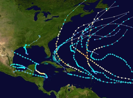
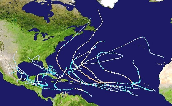
Tracks of Atlantic Hurricanes, 2011

Tracks of Atlantic Hurricanes, 2011

In April, the prediction for the 2011 Atlantic/Caribbean hurricane season was for 16 tropical cyclones, including 7 tropical storms, 4 moderate hurricanes (Category 1 or 2 on the Saffir-Simpson scale) and 5 strong hurricanes (C 3, 4 or 5).

This prediction proved to be quite good. In the event, there were actually 19 tropical cyclones, including 12 tropical storms, 4 moderate hurricanes (C1, C2) and 3 strong hurricanes (one C3 and two C4).

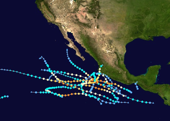
Tracks of Pacific Hurricanes, 2011

Tracks of Pacific Hurricanes, 2011

On the Pacific coast, the 2011 season saw 11 tropical cyclones including 1 tropical storm, 4 moderate hurricanes and 6 strong hurricanes. Fortunately, almost all these cyclones remained out at sea and only Hurricane Jova, which reached category 3 in early October, caused any significant damage on land (see Hurricane Jova smashes into Barra de Navidad and Melaque on Mexico’s Pacific Coast).

Want to read more?

Related posts:

Mexico’s 2011 drought is raising the price of basic foodstuffs

 Mexico's geography in the Press  Comments Off on Mexico’s 2011 drought is raising the price of basic foodstuffs
Dec 052011
 

This year’s drought – see Many states in Mexico badly affected by drought is now widely viewed as the worst to occur since modern record-keeping for precipitation began about 80 years ago.

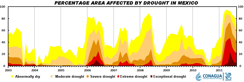
Short-term droughts are not unusual in Mexico. As the graph shows, there is a clear cyclical pattern to the timing of short-term droughts in Mexico. This is because most of the country receives almost all its annual precipitation in just a few months, from May or June (depending on precise location) to September-October.

The scale of the current drought is readily apparent from the graph. This year, far more of the country is affected, and the level of drought is far more severe.

Seasonal drought in Mexico, 2003-2012
Seasonal drought in Mexico, 2003-2012. Click to enlarge.

The drought is having numerous adverse impacts

It is already having an effect on food prices. Several of the basic foodstuffs  making up Mexico’s basic basket of goods for economic indices such as the inflation index, have risen sharply in price in recent months. A shortage of corn has led to a 70% increase in imports of yellow corn from the USA.

Incredibly, Mexico, the home of corn, is now the world’s second largest importer. Corn, as we have noted in previous posts, is a vital ingredient in Mexican cuisine, and is particularly important in the southern half of the country, especially in the more rural and indigenous areas. The shortage of corn has led to a rise in the price of tortillas, a dietary staple in almost all of the country. Tortilla prices have risen up to 18%, many times Mexico’s overall inflation rate of about 3.5%.

The production of chiles, another staple of the Mexican diet, has also fallen due to the drought, by an estimated 40%. In Zacatecas, that state’s 2,500 chile-growers will have produced 120,000 tons of green chile and 62,150 tons of dried chile this year, even though they have only been able to harvest chiles twice this year, rather than the normal four times. The state is the leading source of dried chile in Mexico. The area cultivated for chiles in Zacatecas has also fallen this year, to 31,300 hectares. The decrease in production has had a direct impact on the number of harvesting jobs available, since each hectare of chile cultivation usually means 150 seasonal jobs. The production shortage for chiles will be offset by more imports from Peru and China.

At latest count, 770 municipalities are now suffering from drought, and at least 2.5 million people in 1500 communities are left with insufficient drinking water. In the state of Durango alone, more than one million people are currently experiencing extreme drought, and 149 communities are completely without drinking water.

The long-term outlook is not favorable for these areas since climate change is expected to increase both the frequency and severity of droughts over the next twenty to thirty years.

Related posts:

Unusual hazard: gasoline pours out of storm drains in Poza Rica, Veracruz

 Mexico's geography in the Press  Comments Off on Unusual hazard: gasoline pours out of storm drains in Poza Rica, Veracruz
Nov 262011
 

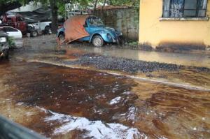
Recent floods in parts of the city of Poza Rica (Veracruz) resulted in an unusually dangerous situation. As groundwater rose following exceptionally heavy rains, a mixture of water and oil flowed out of some street drains.

street awash with oil photo

A Poza Rica street awash with oil and water. Credit: La Voz del Sureste

The precise cause is unknown. The city is blaming the state oil giant Petroleos Mexicanos (Pemex). Pemex claims that the hydrocarbons are natural tar, deposits of which underlie some parts of the region.

Whatever the cause, the flooding resulted in extremely hazardous conditions in the Chapultepec colonia, where Ébano, Nogal, Chopo, Eucalipto, Ciprés, Fresno and Sabino streets were badly affecfed, and in the Cazones colonia, where the aptly-named Pozo 13 (Well 13) was awash with oil. The mayor of Poza Rica was quoted as saying that “The rivers of crude left parked cars completely covered.”

Families living in the affected areas were evacuated temporarily for their own safety. Fortunately, local authorities, assisted by Environmental Protection officials and Pemex experts, were able to quickly bring the situation under control, without any loss of life or serious injuries.

Sources:

  • Brota hidrocarburo de drenajes en Poza Rica (Diario La Voz del Sureste online)
  • Concluyen limpieza de derrame de hidrocarburo en Poza Rica (xeu.com.mx)


Many states in Mexico badly affected by drought

 Mexico's geography in the Press, Updates to Geo-Mexico  Comments Off on Many states in Mexico badly affected by drought
Nov 232011
 

Much of Mexico is currently affected by some degree of drought (see map below). The National Meteorological Service (SMN) reports that September was one of the driest months in some 70 years. All the signs suggest this is the worst year for drought since 1941. The worst affected states are Sonora, Chihuahua, Coahuila, Durango, Nuevo León and Zacatecas. (Paradoxically, some parts of southern Mexico, especially in the states of Oaxaca and Tabasco, have experienced serious flooding in recent months).

In the drought zones, emergency programs are getting underway to provide temporary work for many rural dwellers and to supply potable water to the worst affected settlements. In addition to crop losses, up to one million head of cattle will have been put down by year-end in northern states as a direct result of the drought, since farmers do not have sufficient fodder available to feed them as usual.

While some cattle have been exported to the USA, local meat prices will be driven down by the increase in supply, making many farmer’s livelihoods even more precarious. Many farmers will need federal assistance to overcome this latest crisis.
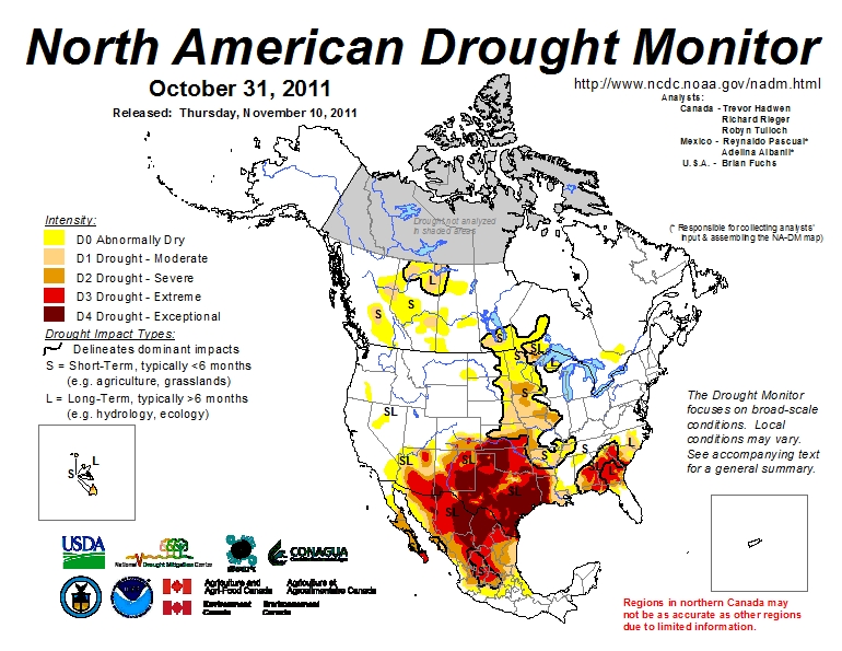
Areas suffering from drought, October 2011

Areas suffering from short-term and long-term drought, October 2011. Click map to enlarge

Durango faces the worst drought for 100 years

In Durango, water has been provided to 32,691 residents in 10 municipalities, with another 36 municipalities to be supplied in the current phase of emergency assistance. Officials in Durango say it is the state’s worst drought for 100 years, with most larger reservoirs in the state now holding between 20% and 40% of their capacity; one reservoir is already down to less than 10% of its.

Irregular rains over the past few months have done little to replenish reservoirs, leaving farmers in despair. The long-range forecast does not appear to offer them much consolation, with the drought expected to last well into next year.

By mid-September, some parts of Durango had received less than 140 mm of precipitation so far ths year, well below the 425 mm registered for the same period in 2010.  The only hope for local farmers appears to be if late season hurricanes bring far more rain than expected to this region.

The drought news from other states

In Chihuahua, 589 tankers have delivered water to settlements housing 62,000 in 15 different municipalities: Guazapares, Janos, Manuel Benavides, Morelos, Moris, Ocampo, Ojinaga, Urique, Uruachi, Aldama, Balleza, Bocoyna, Guachochi, Guadalupe and Calvo.

In Zacatecas, a “state of emergency” has been declared for 52 of the state’s 58 municipalities. More than 150 communities are seriously affected, especially smaller communities in the municipalities of Fresnillo, Jerez, Guadalupe, Tlaltenango, Nochistlán, Atolinga, Villa de Cos, Genaro Codina and Teúl de Gonzalez Ortega.

Drought has affected 288,000 hectares of rain-fed crops in Guanajuato. The greatest losses are of corn, beans, wheat, sorghum and other grains, with the worst-hit areas located in the northern part of the state. More than a million liters of potable water have been supplied to 18,000 inhabitants living in 133 settlements in the state, located in the municipalities of Atarjea, Doctor Mora, San Diego de la Unión, San Felipe, Santa Catarina, Tierra Blanca, Victoria and Xichú.

Horticulturalists in Sinaloa growing vegetables, grains and fruit for export want 30 million dollars in emergency funds to restore irrigation to 700,000 hectares of productive land. More than 200,000 seasonal jobs are at risk.

Related post:

Mexico’s water resources and water-related issues are the subject of chapters 6 and 7 of Geo-Mexico: the geography and dynamics of modern Mexico. Ask your library to buy a copy of this handy reference guide to all aspects of Mexico’s geography today! Better yet, order your own copy…


Mexico, USA and Canada cooperate to produce monthly drought maps

 Books and resources  Comments Off on Mexico, USA and Canada cooperate to produce monthly drought maps
Nov 192011
 

The North America Drought Monitor (NADM) is a “cooperative effort between drought experts in Canada, Mexico and the United States to monitor drought across the continent on an ongoing basis”. The program began  in 2002 . The NADM is an extension of an earlier version that was limited to the USA.

The NADM combines multiple indices and local information to produce “drought monitor” maps that best reflect the consensus of numerous scientists, some working at state or federal level, and others working in tertiary education and research.

What exactly is a “drought”?

The basic definition of a drought is a prolonged period of abnormally low precipitation. In practice, this means a period when precipitation is significantly less than would normally be expected for the time period under consideration. The amount of precipitation that is “normal” varies greatly from one area to another, and can also vary with the seasons. Low precipitation in a desert would not necessarily indicate a drought! On the other hand, low precipitation in a rainforest almost certainly would indicate a drought. Since most of Mexico experiences a dry season and a rainy season each year, this further complicates the picture. Not only is it important to know how much precipitation falls, but it is also important to know when it falls.

Areas suffering from drought, October 2011
Areas suffering from short-term and long-term drought, October 2011. Click map to enlarge

This definition must be borne in mind when looking at the Drought Monitor maps, as should the seasonality of precipitation throughout most of Mexico, and the distribution of precipitation, which varies greatly from north to south.

The NADM maps show that the drought situation can change quite rapidly from one month to the next. (Use the link above to compare February and March 2011, for example, or March and April 2011).

In a future post, we will take a closer look at the impacts of the drought (shown on the map) that currently affects much of northern Mexico.

Hurricane Jova smashes into Barra de Navidad and Melaque on Mexico’s Pacific Coast

 Mexico's geography in the Press  Comments Off on Hurricane Jova smashes into Barra de Navidad and Melaque on Mexico’s Pacific Coast
Oct 142011
 

The twin coastal towns of Melaque and Barra de Navidad in the state of Jalisco felt the full force of Hurricane Jova earlier this week. Barra de Navidad has great historical importance as one of the shipbuilding ports where the Spanish built the ships which traversed the Pacific Ocean to the islands of the Philippines.

Full details are only beginning to emerge of the damage done, but the following links show the storm’s path, and some of its immediate impacts:

Fortunately, Hurricane Jova had lost some of its strength by the time it slammed into the coast as a Category 2 hurricane on 12 October. It had previously packed winds of up to 160 km/hr. Even so, it brought torrential rain to coastal areas between the major resorts of Puerto Vallarta and Manzanillo, and heavy rain inland as far as Guadalajara (about 400 km from the coast). In Guadalajara, the flag-raising ceremony to mark the start of the 2011 Pan-American Games was postponed by a day because of continuous rainfall.

In Puerto Vallarta, where several Pan-American Games events are scheduled to be held, including sailing, triathlon, beach volleyball, and open water swimming, authorities secured boats and reinforced the beach volleyball courts with sandbags.

The catastrophe-modelling firm AIR Worldwide says Hurricane Jova will have caused less than $52m of damage as it hit a sparsely populated stretch of Mexico’s Pacific coast downgraded as a Category 2 hurricane.

Many smaller settlements, including Cihuatlán, La Huerta, Villa Purificacion, and Cuautitlán de García Barragán were temporarily cut off as floodwaters made the main coastal highway impassible. Streets in many towns were inundated.

Details of the storm’s track and intensity will (in due course) be available at the National Hurricane Center’s archive for 2011 Eastern Pacific Hurricanes.

Previous hurricane-related posts include:

Hurricanes and other climatological phenomena are analyzed in chapters 4 and 7 of Geo-Mexico: the geography and dynamics of modern Mexico. Buy your copy today, so you have a handy reference guide available whenever you need it.

Examples of high risk settlements located near Pemex pipelines

 Mexico's geography in the Press  Comments Off on Examples of high risk settlements located near Pemex pipelines
Sep 292011
 

There have been several fatalities associated with Pemex pipeline explosions in recent years, sometimes resulting from illegal attempts to tap into the lines. They include the disastrous blast in San Martin Texmelucan, Puebla, in December 2010 that killed 28 people. It therefore comes as something of a surprise to find press reports highlighting areas where people continue to live in vulnerable locations exposed to unacceptably high risks. In this post, we look at three examples, from the states of Oaxaca, Veracruz and Hidalgo respectively.

According to a report by Martha Izquierdo in Mexico City daily Reforma, more than 300 families in the industrial port of Salina Cruz (Oaxaca) live in homes sitting atop Pemex pipelines.

Previous municipal administrations are alleged to have issued permits for their construction, in total disregard for the potential dangers involved. The current municipal and state authorities have no plans to relocate these families, despite the daily risk they face. The pipelines carry oil into Pemex’s Salina Cruz refinery.

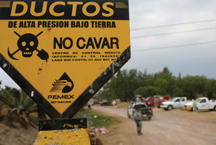
Pemex pipeline danger sign
Pemex pipeline warning sign. Credit Revista Buzos

The areas at risk are in the Deportiva, Hugo Mayoral, San Pablo Norte and San Pablo Sur districts (colonias) of Salina Cruz. Besides the homes, there are also vehicle repair shops, restaurants and even a shopping center in the zone along the pipelines.

In Coatzacoalcos, Veracruz, near another Pemex refinery called Pajaritos, a small town called Mundo Nuevo has sprung up to house construction and refinery workers. Its 20,000 residents live in close proximity to no fewer than 26 pipelines entering and leaving the refinery and, according to this report from  Jesús Lastra Ríos, they are not even certain of what materials are being carried in the pipelines, let alone their toxicity, flammability and explosiveness. In this case, apparently, the state “risk atlas” includes details of the pipeline diameters, but not their contents.

Clearly, settlements of any kind should not be allowed so close to Pemex pipelines, but there are many similar instances in Veracruz, as there are in many other states.

In Hidalgo state recently, the Education Ministry identified three schools as having been built “in high-risk areas near Pemex pipelines”. The state is making emergency plans to relocate the schools at an estimated cost of around $5 million. The schools are in the municipalities of Villa de Tezontepec, Ajacuba and Tlaxcoapan. The Hidalgo state government has a “risk atlas” covering landslide and other risks, but, apparently, most existing maps are based mainly on events that have already occurred.

These three examples serve to illustrate the seriousness of the situation in many parts of Mexico where planning restrictions have not been effectively enforced, and where risk assessments permitting accurate mapping of the most vulnerable areas have still not been completed and are therefore not available to municipal or state authorities.

Related posts:

To read more about the geography of hazards in Mexico, use the “Hazards” tag: http://geo-mexico.com/?tag=hazards

Natural hazards in Mexico are discussed in detail in chapters 2, 4 and 7 of Geo-Mexico: the geography and dynamics of modern Mexico.

Driving in Mexico: is it safe relative to other countries?

 Books and resources  Comments Off on Driving in Mexico: is it safe relative to other countries?
Jul 282011
 

About 24,000 people were killed last year in traffic accidents in Mexico according to Ángel Martínez, Director of the Mexican Traffic Safety Research Center (Spanish acronym CESVI) . In the USA, the number was about 33,000 in 2010. Does this mean that is safer to drive in Mexico than the USA?

The simple answer is “no” because the USA has three times as many people, about ten times as many registered vehicles, and probably drives over ten times as many vehicle-miles as Mexico. Comparing traffic deaths among countries is relatively complicated because the data are often lacking or not comparable.

A large 2009 World Health Organization (WHO) study indicates that traffic deaths are related to numerous factors. Obviously, the number, age, condition and mix of motor vehicles are very important. Two-wheeled motor vehicles can be more dangerous than automobiles, buses or trucks. Furthermore, road quality, traffic infrastructure, laws, and enforcement are major factors. Many countries do not require use of seat belts, helmets or child seats. The training, skill level and behavior of drivers, as well as pedestrians, are also important. Other factors are alcohol use by drivers and pedestrians, as well as the quality and efficiency of emergency medical teams and health care systems.

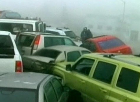
50-vehicle pile-up in fog, Saltillo, January 2011

50-vehicle pile-up in fog, Saltillo, January 2011

According to the WHO study, Mexico ranked 12th in the world in total traffic fatalities. China ranked first with 221,000 deaths per year, followed by India, Nigeria, Pakistan, Indonesia, Russia, Brazil, USA, Egypt, Ethiopia, Iran and then Mexico. Total deaths are related to population, number of vehicles and pedestrians, poor traffic control and emergency medical systems, as well as crowded roads shared by everything from trucks, buses, cars and motor bikes to livestock and pedestrians.

Mexico has about 21 traffic deaths per year per 100,000 population. This is a fairer way to compare countries. On this statistic, Mexico does slightly worse than Brazil (18), China (17), India (17), Indonesia (16), and Thailand (20). Though Mexico is slightly better than Peru (22), Venezuela (22), Russia (25), and Pakistan (25), considerable improvement is needed. President Calderón has set as a goal of reducing traffic deaths by 50% by 2020. Mexico is significantly behind some of the other Western Hemisphere countries such as Canada (9), USA (11), Argentina (14), Colombia (17) and even Guatemala (15).

The major countries with the safest traffic are Japan (5), UK (5), Germany (6), and France (8). The least safe countries are mostly in Africa and include Egypt (42), Ethiopia (35), Kenya (34), Nigeria (32), the Congo (32) and South Africa (33).

Wear your seat belt and drive safely!

More problems for residents of Valle de Chalco on the south-eastern edge of Mexico City

 Mexico's geography in the Press  Comments Off on More problems for residents of Valle de Chalco on the south-eastern edge of Mexico City
May 112011
 

More than 200 homes in the low-income settlement of Valle de Chalco on the south-eastern edge of Mexico City, in the State of México, were flooded by raw sewage last month. The affected homes were in San Isidro and La Providencia, in Valle de Chalco (see map).

Mexico City cracks map
Locations in Valley of Mexico with high incidence of ground cracks. Cartography: Tony Burton; all rights reserved.

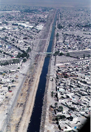
At least 500 residents faced a grim clean-up following several days of flooding. The problem was caused by a 30-meter-long crack in a surface sewage canal known as the Canal de la Compañia. The crack allowed 6,000 cubic meters a second of raw sewage to inundate nearby streets and homes. The federal water authority, Conagua, said that it would take three weeks to complete repairs to the canal wall.

Canal de la Compañia, Chimalhuacán

Canal de la Compañia, Chimalhuacán

The canal wall is thought to have been put under too much pressure due to the unfortunate combination of unusually heavy rains and a blockage occasioned by accumulated garbage such as plastic bags. It is possible that continued ground settling –More ground cracks appearing in Mexico City and the Valley of Mexico – also contributed to the problem. José Luis Luege Tamargo, the head of Conagua, placed much of the blame for the most recent flooding on the local municipal authorities of Ixtapaluca for not having ensured that no garbage was dumped anywhere in or near the Canal.

The 260 families and small businesses affected were all given some immediate financial assistance via 20,000-peso payment cards valid at any Soriano supermarket. In addition, authorities have pumped out basements and begun an emergency vaccination campaign.

The Canal de la Comañia’s walls have failed three times in the past decade, with serious flooding each time; the most recent disaster was in February 2010, when 18,000 people were forced to flee the rising wastewater. Conagua has reportedly proposed a more permanent remedy involving the rerouting of 7 km (almost 5 miles) of canal. The project would take two years to complete, with an estimated cost of 300 million pesos ($25 million).

How do El Niño events affect Mexico?

 Excerpts from Geo-Mexico  Comments Off on How do El Niño events affect Mexico?
Apr 112011
 

La Niña and El Niño are two major periodic disturbances to the normal oceanic and atmospheric circulation patterns over the Pacific Ocean which have widespread effects around the world. The normal circulation in the equatorial Pacific (the Walker circulation cell) results from a low pressure area over the western Pacific (due to warm surface ocean temperatures) and a high pressure area over the eastern Pacific (due to the upwelling of cold ocean water off the coast of Ecuador). Surface trade winds blow from east to west, while high altitude air flow is from west to east.

A La Niña event is an intensification of the normal Walker cell. This results in warmer and drier conditions than normal, rarely with serious consequences for Mexico.

However, during an El Niño Southern Oscillation (ENSO) event, the Walker circulation pattern is essentially reversed. Early in the year, warm ocean water extends much further east, causing warm moist air to rise off the coast of South and Central America, bringing heavy rainfall to areas along the west coast of Mexico. The El Niño in 1998 raised the temperature of water off Mexico’s Pacific coast by some 3° to 5°C (6° to 9°F) and also increased the humidity considerably. Historically, ENSO events have occurred every four to seven years, but their frequency may now be increasing.

The effects of an ENSO event are also felt on the Gulf coast. The low pressure area resulting from the air rising off the western coast causes air from further east to be dragged across Mexico. This means that more cold fronts or nortes enter north and central Mexico. Winter precipitation in these areas increases significantly, especially in the north, and temperatures are much cooler than usual. Flooding can result in coastal areas. ENSO effects are also felt in other parts of the world.

In Mexico, ENSO events not only affect winter precipitation but also summer precipitation, which is more critical for farmers. This is because they push the equatorial Intertropical Convergence Zone (ITCZ), where the north-east and south-east trade winds meet, further south. This reduces the convective activity and rainfall in Mexico’s central highlands. Furthermore, this may reduce cloud cover and therefore increase solar radiation and evapotranspiration, making the ground even drier.

In summary, subsistence corn (maize) farmers find that their cooler, wetter winter than normal is immediately followed by a hotter and drier summer growing season. This can have disastrous consequences for their food security. The rapid onset of changed conditions does not allow much time for adequate adjustments to be made to their choice of crops or farming methods.

Historical analysis combined with greater climatological understanding shows that many of the worst droughts and floods in Mexico have been associated with either ENSO events or with the related Pacific-North American Oscillation. Perhaps 65% of the variability of Mexican climate results from changes in these large-scale circulations.

The naughty nortes of Mexico

 Excerpts from Geo-Mexico  Comments Off on The naughty nortes of Mexico
Mar 292011
 

Mid-latitude storms known as nortes (northers) disturb the normal weather patterns up to 20 times a year during winter, from November to March. They occur when northern polar air moves south into northern and central Mexico.

They bring low pressure (cyclonic) conditions, heralded by the arrival of a cold front. The polar air displaces the warmer surface air, forcing it to rise as the cool air pushes its way underneath. At the surface, a sudden drop in temperature and the advent of cold winds marks the passage of the front, followed by several days of overcast skies with light rains or drizzle, onomatopoeically called chipichipis in some areas.

Rains from nortes are heavier on the northern or eastern sides of mountains where the cool air is forced to rise. As the front passes, the temperature can drop by 5–8 degrees C (9–14 degrees F) in a few hours.

From an agricultural perspective these rains are a welcome sight for farmers, helping to improve grazing land and reduce the chances of wind-blown soil erosion. However, the winds can play havoc with shipping in the Gulf of Mexico and result in ports being temporarily closed. Veracruz and Tampico are regularly affected.

Cold weather wreaks havoc on crops in Sinaloa, Mexico

 Mexico's geography in the Press  Comments Off on Cold weather wreaks havoc on crops in Sinaloa, Mexico
Feb 212011
 

Corn production has been the core of Mexican agriculture throughout its history, and continues to be very important. Production has increased by more than 40% since 2000. Currently corn is grown on about half of all agricultural land. However, corn is a rather low value crop and accounts for only about 14% of total crop value.

Corn, for both human and livestock consumption, is grown virtually everywhere in Mexico and is the leading crop in 17 of the 32 states. The leader in volume of corn produced is Sinaloa with 28% of the national total. Other major corn states are Jalisco (12%), State of Mexico (6%), Michoacán, Guanajuato and Guerrero (5% each).

The unusually cold weather in early February 2011 hit farming areas in northern Mexico particularly hard. Farmers in Sinaloa, the “Bread Basket of Mexico,” report that 300,000 hectares (750,000 acres) of corn were destroyed after unusually cold temperatures in the first few weeks of the year. A further 300,000 hectares suffered some damage. Sinaloa has 470,000 hectares of farmland devoted to the white corn used to make tortillas; 90% of this area has been damaged. Heriberto Felix Guerra, federal Secretary for Social Development (SEDESOL) called the weather-related losses the worst disaster in Sinaloa’s history. The economic loss could exceed three billion dollars.

The federal Agriculture Secretariat is rushing urgent aid to farmers, including tax breaks and low-interest loans for seed, in the hopes that many of them can replant their corn crop while there is still time. As of today, more than 130,000 hectares of corn in Sinaloa have already been replanted. The aim is to reseed between 200,000 and 300,000 ha (500,000-750,000 acres) of corn, for an eventual harvest (in Sinaloa) of 3 million metric tons of corn. The reseeding must be completed by 10 March as, after that date, there are too few “growing days” to guarantee a harvest. Average yields in Sinaloa for white corn are expected to fall from their usual 10 tons/ha to around 7 tons/ha this year.

Mexico has an annual shortfall in corn production and always has to import some corn (mainly from the USA and South Africa) to meet total domestic demand. This year, the government is considering raising its usual import quotas to ensure ample supplies of corn (and tortillas) for the coming year. Corn prices have already shot up; Mexico’s imports are going to cost a lot more than in recent years.

Citrus orchards, tomato crops and other vegetables were also decimated. Tomatoes are by far the most important horticultural crop in Sinaloa, but other crops affected include green beans, squash and chiles. It will be another 6 weeks to 2 months before another tomato harvest is possible. The price of tomatoes also rose immediately and could double, at least temporarily, within the next few weeks.

The Mexican tomato crop is mainly the larger Roma variety which is widely used in the fast food industry. Already at least one fast-food chain in the USA is adding tomato slices to hamburgers only on request; the smaller tomatoes used in salads are not affected by the recent cold snap.

Previous related posts:

More ground cracks appearing in Mexico City and the Valley of Mexico

 Mexico's geography in the Press  Comments Off on More ground cracks appearing in Mexico City and the Valley of Mexico
Jan 192011
 

The continued sinking of some parts of Mexico City in response to the over-extraction of water from underground aquifers, and consequent shrinking of the subsoil, has resulted in dozens of cracks in recent years. As noted in a previous post – Why are some parts of Mexico City sinking into the old lakebed? – some buildings in Mexico City have dropped more than seven meters (23 ft) since 1891.

According to Gabriel Auvinet Guichard, a researcher at the Engineering Institute of the National University (UNAM), cracks are becoming increasingly frequent. The largest cracks are up to 22 meters (72 feet) deep and 30 meters long. The cracks damage buildings and infrastructure (especially roads and water pipes), and have alarmed residents in some areas in the city.

Auvinet’s team at UNAM’s Geoinformatics Laboratory is compiling a database of all known cracks. They plan to produce maps showing the incidence, location and origin of the cracks to help construction companies meet building regulations. The database has records of 380 fissures at present, but is still far from complete.

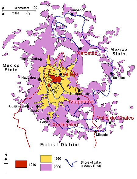
Some areas in the Valley of Mexico are much more prone to the earth movements leading to cracks than others. The areas with a high incidence of cracks include Iztapalapa, Chalco, Xochimilco, Xalostoc and Vallejo (see map).

Mexico City cracks map

Locations in Valley of Mexico with high incidence of ground cracks. Cartography: Tony Burton; all rights reserved.

Chapter 23 of Geo-Mexico: the geography and dynamics of modern Mexico looks at urban issues, problems and trends. To preview more parts of the book, click here and use amazon.com’s “Look Inside” feature.

Dec 062010
 

Cancún is Mexico’s premier tourist destination, attracting more than 3 million visitors a year. A recent Associated Press report by Mark Stevenson highlights the problems faced by the resort due to the erosion of its beaches.

Cancún was developed on formerly uninhabited barrier islands on Mexico’s Caribbean coast. The islands were low-lying sand bars, held together by beach vines and the dense, interlocking roots of coastal mangroves. Hurricanes periodically swept over these small islands blowing loose sand towards the beaches on the mainland. Despite the occasional hurricane, the sandbars survived more or less unscathed until construction of Cancún, Mexico’s first purpose-built tourist resort, began in 1970.

As Cancún has grown, so the damage from hurricanes has become more serious. Category 4 Wilma in 2005 was especially destructive.

Cancún beach erosion

Cancún beach erosion. Photo: Dario Lopez-Mills/AP

Why has hurricane damage increased since 1970? Several factors are thought to play in a part in causing the increased rate of erosion of Cancún’s beaches in recent years:

  • hotels have been built too close to the shore, and too many are high-rise buildings. High-rise hotels deflect some of the wind downwards towards the ground. These wind eddies can stir up any dry surface sand in a process known as deflation.
  • hotels are too heavy. The sheer weight of high-rise hotels compacts the largely unconsolidated sediments beneath them, rendering the sediments less able to store or absorb excess water, and more liable to subsidence and structural problems. Extra weight also increases the load on slopes and leads to a higher incidence of slope failure.
  • coastal mangroves have been destroyed, removing their ability to protect the shoreline during storm events.
  • most beaches have been stripped of their original vegetation. The original beaches were protected by various adventitious vines which were quick to colonize bare sand. They would simultaneously help hold the sand in place, protecting it from wind action, and gradually add to the organic content of beaches to a point where they could support other, larger plants. Native vegetation has been mercilessly eradicated from Cancún’s beaches to create the tourism “ideal” of uninterrupted swathes of white sand.

It also appears that hurricanes and other tropical storms have become more frequent in recent decades, perhaps as a consequence of global climate change. The situation has also been exacerbated by the gradually rising sea level. Sea level on this coast is rising at about 2.2 mm/y.

Why have some of the efforts made to mitigate the beach erosion only made the situation even worse?

Following strong hurricanes (such as Wilma in 2005) Cancún has lost most of its beaches. The first attempt at beach restoration in 2006 cost 19 million dollars. In 2009, an even costlier (70 million dollar) beach restoration was carried out, using sand dredged from offshore. In one sense, the project was a resounding success. A new beach up to 60 meters wide, was created along some 10 km of coastline.

However, this new beach came at a considerable ecological cost. The pumping of sand from offshore disturbed the seafloor and damaged sealife, including populations of octupus and sea cucumbers. Fine sediments raised by the pumping traveled in suspension to nearby coral reefs, where it also had deleterious impacts.

In addition, the new beach is already being eroded away (some estimates are that up to 8% of the new sand has already been washed or blown away), so presumably if Cancún’s beaches are to be maintained in the future, beach restoration will have to become a regular event.

One hotel erected a breakwater or groyne on its beach to retain all the sand being carried along the coast by the process of longshore drift. The Associate Press article ends with a wonderful story of how the beach in front of this particular hotel was cordoned off by marines last year on the grounds that it was stolen property.

Link to 2013 news article: A fortune made of sand: How climate change is destroying Cancun

Tourism is one of Mexico’s major sources of revenue. But tourism, especially high-rise mass tourism such as that characterized by Cancún, comes with a hefty price tag. Policy-makers need to decide whether this price tag, which will only rise further in the future as we continue to damage our natural environment, is really one that is worth the cost.

Chapter 19 of Geo-Mexico: the geography and dynamics of modern Mexico looks in much more detail at Mexico’s purpose-built resorts as well as many other  aspects of tourism, resorts and hotels  in Mexico. Chapter 30 focuses on environmental issues and trends. Buy your copy today!

How good were the 2010 hurricane predictions?

 Other  Comments Off on How good were the 2010 hurricane predictions?
Dec 042010
 

In an earlier post – How many hurricanes are likely in the 2010 Atlantic hurricane season? – we reported on the predictions for this year’s Atlantic/Caribbean hurricane season

How close to reality did those predictions turn out to be?

The predictions were for 8 tropical storms, 5 moderate hurricanes (1 or 2 on the Saffir-Simpson scale), and 5 severe hurricanes (3, 4 or 5 on the Saffir-Simpson scale). At the end of the season (30 November 2010), there had been 7 tropical storms, 7 moderate hurricanes and 5 major hurricanes. In total, these storms caused 259 deaths directly, and a further 23 indirectly, with total property damage estimated at US$11.4 billion. (Note that not all of these hurricanes affected Mexico).

Atlantic Hurricane tracks, 2010

Atlantic hurricane tracks, 2010. Created by Cyclonebiskit using Wikipedia: WikiProject Tropical cyclones/Tracks. Author: Cyclonebiskit and Syntheticalconnections

So, all in all, the predictions made before the hurricane season started were pretty close to the mark, and this hurricane season was indeed one of the most active on record.

Previous hurricane-related posts include:

Hurricanes and other climatological phenomena are analyzed in chapters 4 and 7 of Geo-Mexico: the geography and dynamics of modern Mexico. Buy your copy today, so you have a handy reference guide available whenever you need it.

How many hurricanes are likely in the 2010 Atlantic hurricane season?

 Mexico's geography in the Press, Updates to Geo-Mexico  Comments Off on How many hurricanes are likely in the 2010 Atlantic hurricane season?
Jul 012010
 

Philip Klotzbach and William Gray, of Colorado State University, have analyzed the atmospheric and oceanic conditions in the Atlantic immediately prior to the 2010 hurricane season. They conclude that this season’s hurricane activity in the Atlantic is likely to be stronger than has been the norm during the past 50 years. They predict that the Atlantic season will see 18 named storms, of which 8 will be classed as tropical storms, 5 as moderate hurricanes (1 or 2 on the Saffir-Simpson scale), and 5 as severe hurricanes (3, 4 or 5 on the Saffir-Simpson scale).

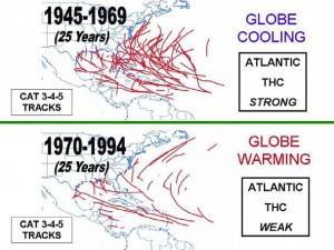
The popular press regularly warns us that on-going global warming will increase the frequency of hurricanes, and their intensity, allegedly due to warmer sea-surface temperatures in the mid-ocean hurricane-spawning areas. Klotzbach and Gray do not believe this. They studied the paths of all severe hurricanes (category 3, 4 or 5) for the fifty years from 1945-1994, dividing this time frame into two 25-year periods (see image).

Tracks of severe Atlantic hurricanes, 1945-1994

Tracks of severe Atlantic hurricanes, 1945-1994. Source: Klotzbach and Gray, 2010. Link to original article at end of this post. Click image to enlarge.

From 1945-1969 was a period of weak global cooling. There were 80 severe hurricanes in this period, some of them taking very erratic paths, with correspondingly dramatic impacts when they struck areas wholly unprepared.

Between 1970 and 1994, the Earth’s temperatures underwent a modest rise (global warming). However, in stark contrast to popular belief, far fewer severe hurricanes occurred during this period (38 in total), and they tended to follow entirely predictable paths.

Clearly the science behind hurricane formation is more complicated than some journalists would have us believe!

Klotzbach and Gray demonstrate the importance of the Thermohaline Circulation (THC) in the Atlantic. The THC is a large-scale circulation in the Atlantic Ocean that is driven by fluctuations in salinity and temperature. The 1945-1969 period coincided with a strong THC, whereas the 1970-1994 period was a time when the THC was weak.

What has happened since 1994? In the fifteen years from 1995-2009 inclusive, the THC was strong, and there were 56 severe Atlantic hurricanes. By comparison, in the preceding fifteen years from 1980-1994, when the THC was weak, only 22 severe hurricanes formed. So it appears that hurricane frequency is not linked to global warming or carbon dioxide (CO2) levels in the atmosphere, but to cyclical changes in the THC.

How accurate are the predictions for the 2010 hurricane season? Only time will tell…

Click here for Klotzbach and Gray’s original article (pdf).

Hurricane warnings in Mexico are the responsibility of the National Meteorological Service (NMS). The NMS also provides an archive of information about past hurricanes.

Hurricanes and other climatological phenomena are analyzed in chapters 4 and 7 of Geo-Mexico: the geography and dynamics of modern Mexico. Buy your copy today, so you have a handy reference guide available whenever you need it.

Giant whirlpool swallows several boats in 1896

 Other  Comments Off on Giant whirlpool swallows several boats in 1896
Feb 152010
 

An anonymous writer in the Los Angeles Times edition of 13 January 1896, reported on a strange and terrifying happening that struck the western part of Lake Chapala (Mexico’s largest natural lake)…

Startling Spectacle at Lake Chapala.

  • Its Waters Swallowed by a Subterranean Cave.
  • Several Pleasure Boats and Their Occupants Engulfed.

SAN DIEGO, Jan. 12.—(Special dispatch.) Prof. E. H. Coffey of this city, has just received a letter from a correspondent. living near Lake Chapala, State of Jalisco, Mex.. which describes some startling phenomena occurring. Lake Chapala is a sheet of water fifty miles long and ten miles wide. The formation of the country around it is purely volcanic.

On the forenoon of January 8 residents in one of the small settlements near the western end of the lake were terrified to see a gigantic whirlpool raging far out on the water. The waters rose in great serpentine movements, and from all directions rushed toward a common center, where a vast cavity seemed to exist. At the same time a heavy, rumbling sound, apparently in the bowels of the earth, took place. The whirlpool was caused by the sudden sinking of a large portion of the lake’s bottom, and before the disturbance subsided several pleasure-boats were drawn into the whirlpool and disappeared with their occupants. It is estimated that a score of lives were lost.

The whirlpool continued for nearly twenty minutes, and when the inhabitants of the surrounding territory turned their eyes from the overwhelming sight they saw that the lake had receded several feet from its former shore line. As the lake is about fifty miles in length, with an average width of ten miles, the enormous amount of water that was swallowed up by the earth may be imagined. After the whirlpool subsided the surface of the lake resumed its placid aspect, and the subterranean rumblings ceased.

There was the greatest excitement among the people for miles in the vicinity of the western end of the lake, the most ignorant and superstitious natives being beside themselves with fear. Years of familiarity with volcanic eruptions and terrestial disturbances did not seem to reassure them during this dreadful experience.

[This post is an edited extract from Lake Chapala Through the Ages, an anthology of traveller’s tales]

Natural hazards in Mexico are discussed in detail in chapters 2, 4 and 7 of Geo-Mexico: the geography and dynamics of modern Mexico.