Jan 272016
 

Mexico has a long history of honey (miel) production. Honey was important in Maya culture, a fact reflected in some place names found in the Yucatán Peninsula, such as Cobá (“place of the bees”).

Faced by the arrival of Africanized bees – The diffusion of the Africanized honey bee in North America – Mexico’s modern commercial beekeepers initially feared the worst. With time, they became less antagonistic to Africanized bees, since, whatever their faults, they proved to be good honey producers.

Honey production in Mexico

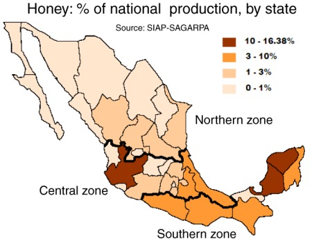
Main honey producing states in Mexico

Honey production has been on the rise in the past decade. Over the past five years, Mexican hives have yielded about 57,000 tons of honey a year, making Mexico the world’s sixth largest honey producing country. Preliminary figures for 2015 show that Mexico produced 61,881 tons of honey.

Mexico is also the world’s third leading exporter of honey with total exports (both conventional and organic honey) of 45,000 tons in 2015, a new record, worth over US$150 million. Mexico’s principal export markets for honey are Germany, the USA, the U.K. Saudia Arabia and Belgium.

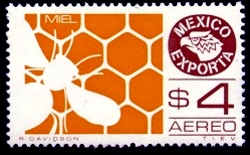
Postage stamp depicting honey exports

Postage stamp depicting honey exports

Other major exporters of honey include China, Argentina, New Zealand and Germany.

There are 42,000 beekeepers nationwide, operating 1.9 million hives; the main producing area remains the southeast, especially the states of Campeche, Yucatán and Quintana Roo. Jalisco, Chiapas, Veracruz, Oaxaca, Guerrero, Puebla and Michoacán are also important for honey production.

The domestic consumption of honey in Mexico has risen from under 200 grams per person in the 1990s to more than 300 grams in 2010. This is mainly due to the use of honey in processed foods such as cereals, yogurts and pastries.
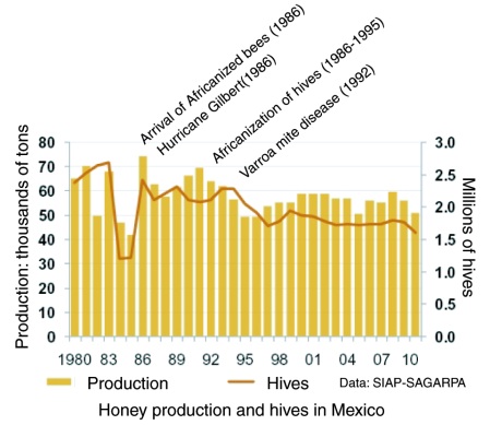
Graph of honey production in MexicoThe major value of bees in an ecosystem is not for their honey production, but on account of their vital role in the pollination of trees and food crops, a contribution valued in the US alone at more than 10 billion dollars.

Views about the pollinating ability of Africanized bees, compared to European or native bees, are mixed. Some farmers dislike having to cope with potentially aggressive bees. Others claim that Africanized bees are far more efficient pollinators than European bees since they forage more often and at greater distances than their European counterparts. The available evidence does not appear to suggest that the arrival of Africanized bees had any impact on crop yields in Mexico.
Which Mexican honey should you buy? For a cautionary tale about choosing the best Mexican honey in overseas stores, see Honey, what’s on that label?

Sources:

  • (a) La producción apícola en México by Carlos Angeles Toriz and Ana María Román de Carlos. (date unknown)
  • (b) “Mexico ranks sixth in honey production” (reprinted from El Economista on mexicanbusinessweek.com), 2011.

This post was first written in October 2011, with updates in October 2015 and January 2016.
New highway in Acapulco

 Mexico's geography in the Press  Comments Off on New highway in Acapulco
Jan 252016
 

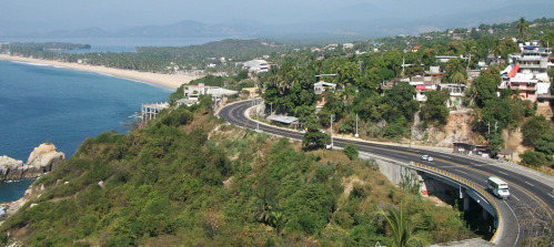
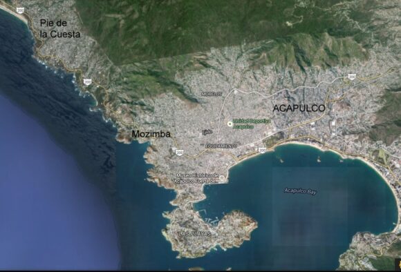
A new highway linking Mozimba and Pie de la Cuesta has been formally inaugurated in Acapulco. According to the SCT (Communications and Transportation Secretariat), the $37 million highway will benefit 860,000 people living in Acapulco and Coyuca de Benítez.

PRY-Mozimba-002

On average, 18,000 vehicles are expected to use the highway each day. The highway reduces travel times from about 30 minutes to 10 minutes.

Acapulco (Google Earth)

Acapulco (Google Earth)

Related posts:

Ecocide in Cancún: mangroves destroyed overnight

 Other  Comments Off on Ecocide in Cancún: mangroves destroyed overnight
Jan 202016
 

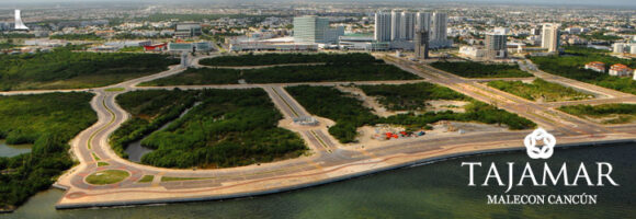
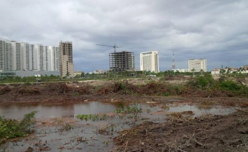
Environmentalists are denouncing the recent overnight destruction of mangroves in the Malecón Tajamar area of Cancún. Malecón Tajamar is a tourist complex with infrastructure financed by Mexico’s federal tourism development agency Fonatur, which has form when it comes to environmental destruction. (See, for example, Conflict at Cabo Pulmo: mass tourism meets ecotourism.)

Development or Environment?

Development or Environment?

Mexico is one of the world’s wealthiest countries in terms of mangroves, with between 600,000 and 900,000 hectares of them in total. (For details about why this range of values is so large, see How fast are mangroves disappearing in Mexico?) To prevent further destruction Mexico enacted federal legislation in 2007 designed to protect existing mangroves.

Credit: Adriana Varillas, El Universal

Credit: Adriana Varillas, El Universal

Despite this, news reports indicate that heavy equipment, protected by armed police, moved in to Malecón Tajamar on 16 January 2016 and proceeded to destroyed 57 hectares (140 acres) of mangroves overnight. This mangrove swamp had been under threat for some time, but the activist movement “Salvemos Manglar Tajamar” had gained considerable public support and managed to bring a temporary halt to further development work in the area.

Greenpeace México alleges that Fonatur falsified environmental assessments, and even denied that any mangroves existed at Malecón Tajamar. According to Greenpeace, municipal, state and federal authorities colluded to ensure that the mangroves would be destroyed and that construction of the tourist complex could continue.

Activists claim that the distinctive and ecologically-important mangrove habitat was home to crocodiles, iguanas, birds and snakes, and that the ecosystem services (fishing, coastal protection, habitat for other species, carbon sequestration, etc) provided by a healthy mangrove swamp outweighed all other options. (For more details, see How valuable are Mexico’s mangrove swamps?)

Greenpeace México not only condemned the destruction of mangroves but called for an immediate halt to work in the area pending a full and open discussion with all stakeholders. They believe that the mangroves could possibly reestablish themselves in time if the area is left untouched.

Work to infill the area cleared of mangroves has now been suspended while animal experts try to rescue, and relocate, as many of the animals who survived the initial disturbance as possible. In theory, Fonatur and the federal Environmental Secreatariat were obligated to ensure that developers had an adequate plan in place, prior to clearance, to relocate all animals, in line with the initial environmental impact report approved in 2005.

Another NGO, Defensores del Manglar, has announced it will submit a formal complaint about recent events at Malecón Tajamar to the headquarters of the Ramsar Convention in Switzerland. The Ramsar Convention, to which Mexico is a signatory, is an international accord for the conservation and sustainable use of wetlands. Defensores del Manglar claims that Malecón Tajamar is protected under the Convention, even though the area does not appear to be specifically included on this list of Mexico’s 140+ Ramsar sites.

Geo-Mexico joins with Greenpeace Mexico and Defensores del Manglar in deploring the destruction of Mexico’s remaining mangroves and will continue to publicize cases where developer greed results in irreversible environmental damage.

Related posts:

The El Triunfo Biosphere Reserve in Chiapas

 Other  Comments Off on The El Triunfo Biosphere Reserve in Chiapas
Jan 182016
 

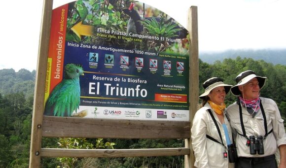
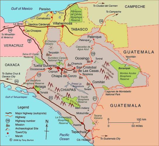
The El Triunfo Biosphere Reserve covers 119,177 hectares in the southern state of Chiapas, in the municipalities of Acacoyagua, Angel Albino Corzo, La Concordia, Mapastepec, Villa Corzo, Pijijiapan and Siltepec. The reserve ranges in elevation from 450 meters above sea level to 2550 meters (8370 ft).

El Triunfo is part of the mountain range known as Sierra Madre de Chiapas in the southern part of the state. It straddles the continental drainage divide. Short rivers on one side flow to the Pacific Ocean. The rivers on the other side of the divide are the start of one branch of the mighty Grijalva-Usumacinta River (Mexico’s largest river in terms of discharge) which flows into the Gulf of Mexico.

el-triunfo

The El Triunfo reserve was first established in 1990. In 1993, it was officially designated a World Biosphere Reserve by the MAB-UNESCO program.

El Triunfo has numerous plants and animals. Its vegetation, representative of several distinct ecosystems, includes evergreen tropical humid forest; mountain rainforest; tropical deciduous rainforest; pine-oak forest; and evergreen cloud forest. On Cerro Ovando alone, about 800 different species of plants have been recorded.

mapchiapas

Map of Chiapas. Click here for interactive map of Chiapas on Mexconnect.com; all rights reserved

Threatened mammalian species found in the reserve include Geoffroy’s spider monkey, margay, the tapir (Tapirus bairdii), jaguar (Panthera onca) and puma. Unfortunately, this means that this is a favored area for wildlife hunters, poachers and traffickers.

The bird fauna is especially distinctive. The reserve is one of the relatively few places in Mexico where ornithologists have the chance to find the horned guan (Oreophasis derbianus), resplendent quetzal (Pharomachrus mocinno), cabanis’ tanager (Tangara cabanisi), azure-ramped tanager and great curassau. The resplendent quetzal is considered one of the most beautiful birds in the Americas, and its feathers were highly prized in pre-Columbian times.

This BBC video is an outstanding visual introduction to the Reserve:

As is the case for other Biosphere Reserves, local people are allowed to live and work in the El Triunfo Reserve. The core area (25,719 hectares) is restricted to conservation and research only, but the buffer/transition areas (93,458 ha) are home to about 12,000 people. El Triunfo is also on the migration route of Guatemalan Indians entering Chiapas either to work (seasonally) on coffee plantations or as the first stage of their journey further north. This floating population is trickier to quantify.

The area was important historically for the production and trade of items such as cacao, quetzal feathers, jade and copal resin. In the 17th century, the population grew rapidly in this region with the establishment of plantations, and later cattle ranches. Coffee was introduced at the end of the 19th century and quickly became the dominant cash crop for most small landowners. Environmental damage, mainly from clearance and cattle ranching, became a major problem, but it was not until the 1970s and pioneering work of Dr. Miguel Alvarez del Toro that any restrictions were placed on land use.

Today, the main economic activities within the buffer areas of the reserve are agriculture (coffee, corn), the collection of Chamaedorea palms, trade, construction and cattle raising.

Several NGOs are working with farmers in the buffer zone to improve their livelihoods and ensure that farming can be carried out sustainably and still support the existing population. For a lively introduction to this topic, try (Co-operative) Value Added on the blog Small Farmers. Big Change. As they say, “a green and more just food system starts with small farmers”.

Related posts:

Cleaning up the Juanacatlan Falls, the “Niagara of Mexico”

 Other  Comments Off on Cleaning up the Juanacatlan Falls, the “Niagara of Mexico”
Jan 142016
 

Geo-Mexico has repeatedly lamented the sad state of the Juanacatlán Falls, the “Niagara of Mexico”, near Guadalajara. More than a century ago, they were considered a national treasure. Indeed, in 1899, they were among the earliest landscapes to be featured on Mexican postage stamps.

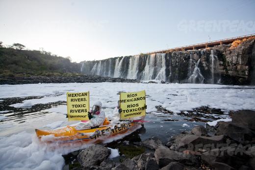
In 2012, we reported that Greenpeace demands action to clean up Mexico’s surface waters. Greenpeace activists chose to protest at the Juanacatlán Falls to call attention to the poor quality of Mexico’s rivers and lakes. The activists cited government statistics showing that 70% of Mexico’s surface water was contaminated, mostly from toxic industrial dumping, rather than municipal sewage.

Greenpeace activists at El Salto de Juanacatlán, 22 March 2012. Photo: Greenpeace.

Greenpeace activists at El Salto de Juanacatlán, 22 March 2012. Photo: Greenpeace.

Last year, we returned to the theme and looked at how the Juanacatlán Falls had been transformed from the “Niagara of Mexico” to the “Silent River”.

Our concluding paragraph on that occasion bears repeating:

Is it too much to hope that the government, corporations and society in the El Salto area can all come together to remedy this appalling tale of willful mismanagement? Local residents are right to insist on the enforcement of existing water quality regulations and on the implementation of remedial measures to reverse the decline of this major river and its once-famous waterfalls. Even more importantly, urgent measures are needed to reverse the deteriorating public health situation faced by all those living or working nearby.

Finally, some good news. Author and activist John Pint, who has done far more than most to publicize the scenic wonders of Western Mexico (including dozens of places that fall way outside the usual tourist guides) reports that the inflow from the 66-km-long Ahogado River, one of the rivers that feeds into the Santiago River just before the Juanacatlán Falls is being cleaned up, with a dramatic, positive impact on the beauty of the Falls themselves. According to Pint’s first-hand report and photographs – Is Guadalajara’s most infamous waterfall now clean? – the smelly, toxic foam that has marred the Falls for decades has become a thing of the past. While this does not mean the water is completely clean, it is certainly an encouraging start.

The Ahogado River itself continues to receive pollutants, and its water remains heavily contaminated, but a  300-million-peso treatment plant, which apparently began operations in 2012, is removing some of the worse contaminants prior to the river joining the Santiago River. There is still a lot of work to be done here if the Juanacatlán Falls are going to be restored to their former pristine beauty, but Geo-Mexico is delighted to hear that progress is (finally) being made.

What a shame that it took the death of eight-year-old Miguel Ángel López in 2008, and years of adverse effects on the health of local inhabitants, before federal and state authorities took decisive action. Later this year, Geo-Mexico hopes to revisit the Falls for the first time in twenty years to see just how much they’ve improved. Watch this space!

Related posts:

Jan 112016
 

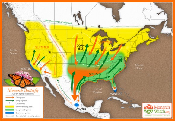
On 9 January 2016, the Google search pages in some countries (including the USA and Mexico but, curiously, not Canada) featured a Google Doodle about the amazing Monarch Butterflies. That day was exactly 41 years from when Ken Brugger and his partner Cathy Trail finally located the exact site of a major overwintering group of Monarch Butterflies in Mexico.

Their effort was part of the research led by Canadian zoologist Fred Urquhart to try to determine what happened to Canadian Monarch Butterflies during the winter. Urquhart knew they fluttered south, but just where did they all go? Urquhart and his team of helpers tagged thousands of butterflies, and gradually homed in on an area of western Mexico straddling the border between the state of México and the state of Michoacán.

Based on original map design created by Paul Mirocha (paulmirocha.com) for Monarch Watch.

Based on original map design created by Paul Mirocha (paulmirocha.com) for Monarch Watch.

It eventually emerged that there were several overwintering sites of Monarch Butterflies in that general area, and much of the zone is now formally protected, with strict conditions for visitors and restrictions on tree cutting and forest thinning.

The Monarch Butterfly overwintering sites are a fitting topic of a Google Doodle. Sadly, the paragraph explaining the Monarch Butterfly Google Doodle repeats a common error about Mexico’s geography, and one we have featured previously on this blog.

It places the Monarch Butterfly overwintering sites in “Mexico’s easternmost Sierra Madre Mountains”. Unfortunately, this phrase, even if oft-repeated on ill-informed websites, is far from true.

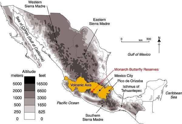
Location of Volcanic Axis and Monarch Butterfly reserves

Location of Volcanic Axis and Monarch Butterfly reserves. Basemap: Figure 3.1 of Geo-Mexico; all rights reserved.

Mexico has three major Sierra Madre ranges: The Western Sierra Madre, Eastern Sierra Madre and Southern Sierra Madre (see map). Mexico’s “easternmost Sierra Madre Mountains” would actually be the Southern Sierra Madre! The Monarch Butterfly reserves are not located in any of these three Sierra Madres; they are happily ensconced in the Volcanic Axis.

Given that Google is reported to be introducing some form of reliability factor into its search algorithms, lending more credence to sites that are “factually accurate” and supported by other sites, this begs the question as to whether the majority is necessarily always right. In this case, while there are numerous web references to the Monarch Butterflies hanging out in “Mexico’s Sierra Madre” mountains, they are all guilty of misrepresenting Mexico’s physical geography.

Geo-Mexico congratulates Google for choosing to feature the Monarch Butterfly and loves the title “Mountain of the Butterflies” but does hope that Google Doodle writers will check their information more carefully next time.

Related posts:

Does Quintana Roo share a border with Guatemala? Not any longer.

 Maps, Updates to Geo-Mexico  Comments Off on Does Quintana Roo share a border with Guatemala? Not any longer.
Jan 072016
 

The state of Quintana Roo is Mexico’s youngest state (together with Baja California Sur), though this is set to change when Mexico City is formally declared a state, probably later this year. Quintana Roo, established in 1974, is well known to tourists because its largest city is the tourist mega-resort of Cancún, on Mexico’s Caribbean coast.

The northern part of Quintana Roo has a shoreline along the Gulf of Mexico. To the west of Quintana Roo lie the states of Yucatán and Campeche. But what about the southern limit of the state? Does it, or does it not, share a border with Guatemala?

In the early 1990s, the answer to this question was certainly “yes”, but things have changed since then, and the correct answer today is “not any longer”.

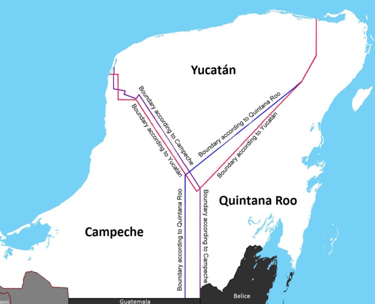
Boundary disputes in Yucatan Peninsula

  • Source: INEGI Map of the Disputed Areas

The state officially claims an area of 44,705 square kilometers (17,261 sq mi), but since 1996-97 there has  been a boundary dispute with the states of Yucatán and Campeche over an area of approximately 10,200 square kilometers (3,900 sq mi).

The contentious boundary issue arose when Campeche delimited a new municipality, Calakmul, in the south-east part of the state, and in doing so “annexed” a piece of Quintana Roo. This shifted the boundary between the two states towards the east, with a knock-on effect that the state of Yucatán also lost a small amount of territory to Campeche. However, Yucatán State simultaneously gained ground from Quintana Roo (see map). Confused? Well, that is really only the beginning, since the states of Yucatán and Campeche also dispute their shared boundary further north.

Confused administrative boundaries are never an easy thing to fix, and land boundary disputes are rife in Mexico at every level, so getting municipal, state and federal authorities to agree on a resolution takes time. The major Campeche-Quintana Roo dispute arose in the late 1990s, but was only finally settled, somewhat arbitrarily by federal court, in 2013. The court sided with Campeche, and Quintana Roo lost its border with Guatemala.

Oh dear… our Geo-Mexico map of Quintana Roo is now out of date!

Related posts:

Is the Mexico-USA tuna war finally over?

 Mexico's geography in the Press  Comments Off on Is the Mexico-USA tuna war finally over?
Jan 042016
 

The World Trade Organization (WTO) issued a final ruling at the end of 2015 favoring Mexico in its long-running trade dispute with the U.S. over the labeling of tuna products. The acrimonious dispute began, more than 20 years ago, because the USA refused to allow Mexican fishermen to use the coveted “dolphin‑safe” label.  The “dolphin safe” labels certify that tuna fishing is in compliance with the International Dolphin Protection Program.

The USA is the world’s largest importer of tuna, imported tuna worth more than one billion dollars in 2014, only 2.1% of which (about 20,000 metric tons) came from Mexico.

Dolphin-safe-logoWhen the dispute began, there is no doubt that Mexican fishermen were catching many dolphins as by-catch. Part of the conflict revolved around the very different methods of fishing employed in the two countries. USA tuna fishermen use long‑line fishing in which every species hooked is killed. Mexican tuna fishermen, on the other hand, use the encirclement method which involves locating tuna by tracking the dolphins that swim with the tuna schools. Large nets are then employed. Any dolphins trapped in the nets are released by hand and returned (alive) to the ocean.

Mexico has introduced far more stringent restrictions on tuna fishing methods since the dispute began, including professional observers on every ship to record each tuna catch; conservation measures over the past two decades have reduced dolphin by-catch by 99%. Mexican fishing methods are now recognized as fully sustainable by the U.N. Food and Agriculture Organization.

Mexico is one of the world’s ten leading tuna producers. Mexico’s tuna catch (mainly yellowfin tuna) rose to 166,000 metric tons in 2013. Domestic demand exceeds 190,000 metric tons a year, so Mexico currently has to import some tuna.

Mexico’s leading producer of canned tuna for the domestic market, worth close to a billion dollars a year, is Pinsa Comercial. Its three main brands – Dolores, El Dorado and Mazatún – account for more than half of the local market. Consumption of tuna has been rising steadily in Mexico, and Pinsa has introduced various new presentations of canned tuna in order to boost it still further from its current level of around eight cans/person/year. Pinsa is a vertically-integrated firm with its own fleet of tuna boats and freezing plants. (The firm also has Mexico’s largest fishing fleet for sardines, used to make fish flour, sold to agricultural and pharmaceutical industries.)

Mexico’s tuna fishing quota, set by the Inter-American Tropical Tuna Fishing Commission, is about 35% higher than its current annual catch. Modernizing the tuna fleet is one way to raise catches and reduce tuna imports.

About 20,000 families in Mexico depend on tuna fishing for their livelihood. This figure includes not only fishermen but also those working in associated processing and packing plants. Mexico’s 130-vessel tuna fleet is the largest in Latin America.

The WTO ruling means that Mexico may now seek compensation for its trade losses.

Related posts:

Mexico continues to be the world’s leading exporter of beer

 Mexico's geography in the Press  Comments Off on Mexico continues to be the world’s leading exporter of beer
Jan 012016
 

For the fifth year in a row, Mexico was the world’s leading exporter of beer in 2014. The final tally shows that Mexico exported 1,700 million liters of beer in 2014, worth 1.6 billion dollars. (Export figures for 2015 are not yet available but will show that Mexico remains well in the lead over Belgium and the Netherlands)

Cuauhtemoc Moctezuma brewery in Monterrey

Cuauhtemoc Moctezuma brewery in Monterrey. Photo: Tony Burton.

Mexico is the world’s sixth largest producer of beer and is predicted to leapfrog Germany and Russia this year (2016) into fourth place, behind only China, the U.S. and Brazil. Significant investments during 2015 have raised national production capacity 39% to 125 million hectoliters.

The two largest beer producers are Grupo Modelo and Cuauhtémoc Moctezuma (formerly Femsa). Grupo Modelo is building a new 310-milion-dollar brewery in the state of Yucatán and also expanding its breweries in Zacatecas and Coahuila. Cuauhtémoc Moctezuma is building a new 450-million-dollar facility in Chihuahua. A third brewer, Constellation Brands, is undertaking a 500-million-dollar expansion to its Piedras Negras plant in Coahuila, which will triple its annual production to 30 million hectoliters by 2017.

Related Posts: