admin

The naughty nortes of Mexico

 Excerpts from Geo-Mexico  Comments Off on The naughty nortes of Mexico
Mar 292011
 

Mid-latitude storms known as nortes (northers) disturb the normal weather patterns up to 20 times a year during winter, from November to March. They occur when northern polar air moves south into northern and central Mexico.

They bring low pressure (cyclonic) conditions, heralded by the arrival of a cold front. The polar air displaces the warmer surface air, forcing it to rise as the cool air pushes its way underneath. At the surface, a sudden drop in temperature and the advent of cold winds marks the passage of the front, followed by several days of overcast skies with light rains or drizzle, onomatopoeically called chipichipis in some areas.

Rains from nortes are heavier on the northern or eastern sides of mountains where the cool air is forced to rise. As the front passes, the temperature can drop by 5–8 degrees C (9–14 degrees F) in a few hours.

From an agricultural perspective these rains are a welcome sight for farmers, helping to improve grazing land and reduce the chances of wind-blown soil erosion. However, the winds can play havoc with shipping in the Gulf of Mexico and result in ports being temporarily closed. Veracruz and Tampico are regularly affected.

Mexico’s pearl collection industry: from boom to bust in less than 100 years

 Other  Comments Off on Mexico’s pearl collection industry: from boom to bust in less than 100 years
Mar 282011
 

In a previous post, we looked at the early history of pearl collecting in Mexico. In this post, we carry the history forward to the present-day.

The search for oyster shells with pearls inside was revolutionized after 1874 when larger vessels, equipped with diving suits and accompanying equipment, first entered Mexican waters. The newer methods permitted access to shells in much deeper water, and lengthened the season, greatly increasing the industry’s productivity. The dangers associated with pearl hunting changed. Equipment failures and lax supervision cost many lives. According to Kunz and Stevenson, divers confined to diving suits for hours at a time frequently suffered rheumatism, paralysis (due to compression and sudden temperature changes) and partial deafness. On the other hand, diving suits reduced shark attacks.

The conditions in Baja California were so favorable for pearling that by 1889, within a few years of its incorporation, the Compañía Perlífera de la Baja California (based in La Paz, and employing about 900 men) had come to completely dominate the world pearling industry. One of the largest pearls found in the Sea of Cortés was one weighing 372 grains found near Mulegé in 1884. On arrival in Paris, its value was estimated at 85,000 francs (about 16 600 dollars at the exchange rate of the time). A 400-grain pearl, found in the same area, now forms part of the Spanish crown jewels.

A 1903 article in The New York Times says that the Baja pearl industry had produced more than two million dollars worth of pearls in 1902, including some of the “finest jewels of this kind found anywhere in the world”. The article describes several individual pearls, and emphasizes that the area is “noted for its fancy pearls – that is to say, the colored and especially the black ones”. As mentioned earlier, the native Indians wore fire-blackened pearls. This seems to have been a particularly prescient choice, given the extremely high premiums long placed on natural black pearls. Even today, at least one firm in Baja specializes in producing cultured black pearls from rainbow-lipped oysters.

As the twentieth century progressed, cultured and artificial pearls were able to out-compete natural pearls in terms of price and availability. By 1936, a century of rampant overfishing of oyster beds had depleted natural stocks to the point where recovery was unlikely. Finding fifteen to twenty small pearls required the harvesting of a ton of oyster shells. To cap it off, an unknown disease then spread rapidly through the remaining oysters, virtually wiping them out.

poster for steinbeck's "the pearl"

By the time the American writer John Steinbeck arrived in Baja in 1941, the glory days of Mexican pearling were over. While in La Paz, Steinbeck came across a legendary (and cautionary) local tale about the greed associated with finding a massive pearl. The story became the catalyst for his novella “The Pearl“, published in 1947, in which Kino, an impoverished pearl diver, finds a huge pearl, “The Pearl of the World” which promises to transform his life. It does, but not in the way one might expect. Kino becomes a brutal sociopath; the story, which was later turned into a movie starring Pedro Armendáriz and María Elena Marquéz, becomes a dark tale of the costs of defying traditional customs.

Today, very few natural pearls are harvested in the Sea of Cortés, but several Baja California firms cultivate pearls, helping to extend a centuries-old industry into the present. It is especially appropriate, therefore, that the city of La Paz, once the center of the world’s pearling industry, is still known, even today, as the “Pearl of the Sea of Cortés”.

Sources / Further reading:

  • Anon. Important Pearl Fisheries on the Coast of California. The New York Times, June 14, 1903.
  • Hardy, R. W. H. 1829 Travels in the Interior of Mexico in 1825, 1826, 1827 and 1828. London: Henry Colburn & Richard Bentley. Reprinted in 1977, Texas: Rio Grande Classics.
  • Kunz, G. F., and Stevenson, C. H. The Book of the Pearl: Its History, Art, Science and Industry. Dover. 2001.
  • Landman, Neil H and Mikkelsen, P. Pearls: A Natural History (Harry N. Abrams, 2001)
  • Mayo, C. M. Miraculous Air: Journey of a Thousand Miles through Baja California, the Other Mexico. Milkweed Editions. 2007.

This post is an edited version of the original article which appeared on MexConnect.

“The book is a masterpiece…” — quote about Geo-Mexico, the geography and dynamics of modern Mexico

 Reviews of Geo-Mexico  Comments Off on “The book is a masterpiece…” — quote about Geo-Mexico, the geography and dynamics of modern Mexico
Mar 272011
 

Douglas Fir, a Californian, is a true world traveler having spent time in literally scores of countries on five continents. With degrees (including one in geography) from both San Francisco and Humboldt State Universities, Douglas has traveled widely in Mexico since the 1950s. Now retired, he and his wife spend every winter in Mexico in the small village of San Pancho on the Nayarit coast.

Geo-Mexico is reader-supported. Purchases made via links on our site may, at no cost to you, earn us an affiliate commission. Learn more.

“…the book is a masterpiece…. It makes such a good textbook, I can’t imagine that it wouldn’t catch fire in Latin American Studies Programs everywhere they’re taught in English. “

“One of the things that makes it so engaging is how well it reads, how accessible and interesting it is.”

He clearly likes Geo-Mexico, the geography and dynamics of modern Mexico, and we believe you will too.

Updates on the geography of Mexico City (26 March 2011)

 Mexico's geography in the Press  Comments Off on Updates on the geography of Mexico City (26 March 2011)
Mar 262011
 

This is the second in our series of periodic round-ups of news items related to the geography of Mexico City. The link to our first update in the series is Updates on the geography of Mexico City (13 December 2010)

Water meters in Mexico City

Ooska News reports that the SACM (Sistema de Aguas de la Ciudad de México, Mexico City Water System) plans to replace, repair or install 600,000 water meters for Mexico City before the start of the rainy season. About 300,000 of the 600,000 meters will be repairs or replacements; the other half are new installations. The cost of new meters will be added to the property’s water bill. The city government is considering how to help low-income residents meet the necessary payments. Residents living in parts of the city which as yet have no meters pay a fixed annual charge for water irrespective of the amount they consume. Having meters installed, so flows and consumption can be monitored, is absolutely essential as the SACM tries to tackle the problem of leaks in the water pipes supplying homes in the city. Some analysts estimate that as much as 25% of the water entering the system is lost through leaky pipes before it reaches its intended end-user.

Plastics recycling in Mexico City

Plastics recycling is one component of Mexico City’s waste separation program, which was established in response to the Solid Waste Law passed in 2003. Members of Mexico’s National Association of the Plastics Industry (a nationwide grouping of plastics makers) are investing $150 million in a pilot project to boost plastics recycling in Mexico City. The project seeks to increase the volume of plastic waste collected and reused by at least 10%.

Currently in Mexico City, only 12% of the 13,000 tons of waste generated each day is plastic, even though, by volume, plastics account for between 30 and 40% of all the waste generated.

Assuming the pilot project proves to be a success, the plastics collection and reuse program could be extended to the remainder of the country, leading to the possibility of doubling current recycling rates to around 35% of the 6 million tons of all kinds of plastics used each year.

Can Mexico’s Environmental Agency protect Mexico’s coastline?

 Mexico's geography in the Press  Comments Off on Can Mexico’s Environmental Agency protect Mexico’s coastline?
Mar 242011
 

A case study of the Cabo Cortés tourism megaproject in Baja California Sur

Baja California Sur MapThe Cabo Cortés megaproject is planned for the area near Cabo Pulmo on the eastern side of the Baja California Peninsula. Cabo Pulmo, a village of about 120 people, is about an hour north of San José del Cabo, and on the edge of the Cabo Pulmo National Marine Park.The area is a semi-arid area, where water provision is a serious challenge.

The megaproject is centered on an extensive belt of mature sand dunes which fringe the coast immediately north of Cabo Pulmo.

The megaproject has been in the planning stages for several years, but Mexico’s federal Environment and Natural Resources Secretariat (Semarnat) recently gave Spanish firm Hansa Urbana the green light to begin construction. The controversial plans for Cabo Cortés involve building on the virgin sand dunes, and will undoubtedly have adverse impacts on the small village of Cabo Pulmo and the ecologically-sensitive Cabo Pulmo National Marine Park.

The Semarnat decision provoked the immediate ire of Greenpeace and other environmental campaigners, as well as local residents who fear being displaced from the small village of Cabo Pulmo by a proposed marina.

The value of the Cabo Pulmo National Marine Park

Jacques Costeau, the famous ocean explorer, once described the Sea of Cortés as being the “aquarium of the world.” This area of the Sea has been protected since 1995 and is now designated a National Marine Park. It was declared a “Natural Patrimony of Mankind” by UNESCO in 2005. The protected area, ideal for diving, kayaking and snorkeling, covers 71 sq. km of ocean with its highly complex marine ecosystem. Dive sites include underwater caves and shipwrecks.

The biological productivity of the Marine Park is amazing. Since the National Marine Park was established, the number and size of fish inside the park boundaries have increased rapidly. Studies show that the number of fish has more than quadrupled since 1995, owing to the exceptional productivity of the offshore reef area. The park is an outstanding example of the success of environmental protection efforts.

Cabo Pulmo is on the Tropic of Cancer, about as far north as coral usually grows. The water temperatures vary though the year from about 20 to 30 degrees C (68 to 86 degrees F). The seven fingers of coral off Cabo Pulmo comprise the most northerly living reef in the eastern Pacific. The 25,000-year-old reef is the refuge for more than 220 kinds of fish, including numerous colorful tropical species. Divers and snorkelers regularly report seeing cabrila, grouper, jacks, dorado, wahoo, sergeant majors, angelfish, putterfish and grunts, some of them in large schools.

The tourism megaproject

The project involves an area of 1,248 hectares (3,000 acres). Swathes of land will be cleared for two 18-hole golf courses. Water provision will require the extraction of 4.5 million cubic meters of groundwater a year from the Santiago aquifer, and the construction of 17 kilometers of aqueducts. The planned marina has 490 berths. When complete, the megaproject will offer more than 27,000 tourist rooms, almost as many as Cancún has today, and almost three times as many as currently in nearby Los Cabos. It is estimated that Cabo Cortés will generate 39,000 metric tons of solid wastes a year (about 2 kg/person/day).

Cover of Greenpeace's position paper on Cabo Cortés

Cover of Greenpeace’s position paper on Cabo Cortés

NGOs oppose Cabo Cortés

When challenged about the legality of granting permission for a project which will impact the Marine Park, Semarnat officials have claimed that the ecological criteria in Semarnat regulations are “suggestive” rather than “obligatory”.

Several NGOs have already launched protest campaigns. Alejandro Olivera is spearheading Greenpeace’s opposition to Semarnat’s decision. He has described the decision as “erroneous” and claims that the megaproject is “not congruent with the prevailing ecological regulations for the region, given that the construction of the marina is in direct contravention of the Los Cabos Ecology Plan which covers this region. The plan expressly prohibits any construction on shoreline dunes. Semarnat maintains that its authorization of a marina and elevated walkways will not affect the “structure or functioning of the area’s sand dune system”.

Olivera emphasizes that Greenpeace is not opposed to tourism as a development strategy, but that it believes in sustainable (responsible) tourism that respects the area’s carrying capacity. Meanwhile, a Greenpeace Spain spokesperson claims that the resort development model of Hansa Urbana, is fundamentally flawed and outdated, and that, when implemented in Spain, it resulted in unacceptable social and environmental costs.

Amanda Maxwell of the Natural Resources Defence Council (NRDC) has written a good summary of why the Semarnat decision should be opposed, entitled “Approval of the Cabo Cortés resort complex–next to the healthiest coral reef in the Gulf of California–is a huge step backward for Mexico

The 120 or so local residents who live in Cabo Pulmo village also oppose the plan and have formed an NGO called Cabo Pulmo Vivo. The existing village, which has no street lights, is a haphazard collection of homes and small businesses, including dive shops, stores and restaurants.

Cabo Pulmo Vivo organized on online petition calling for the Semarnat permits to be revoked.

Personal view, written following a visit in 2008

“We arrive in Cabo Pulmo as the sun is setting, relieved to finally find the end of the initially paved, then dirt, access road, which has been bounded by barbed wire ever since we caught our last clear views of the coast near La Ribera. At intervals behind the barbed wire are warning signs making it very clear that the land either side of the road is private.

Over a beer with Kent Ryan, the owner of Baja Bungalows, our base for the next few days, I learn that the newly erected fences mark the beginning of a major development of the coast immediately outside the National Marine Park. When I eventually got a chance to examine the masterplan, I can only say that I’m glad we visited Cabo Pulmo in early 2008 before this coast is changed for ever.” (Tony Burton in MexConnect)

Further information:

For an exceptionally informative series of papers (in Spanish) on all aspects of tourism and sustainability in Cabo Pulmo,  see Tourism and sustainability in Cabo Pulmo, published in 2008.

Another valuable resource (also in Spanish) is Greenpeace Spain’s position paper entitled Cabo Cortés, destruyendo el paraíso (“Cabo Cortés: destroying paradise”) (pdf file)

An in-depth analysis of drug violence in Mexico from the University of San Diego’s Trans-Border Institute

 Books and resources  Comments Off on An in-depth analysis of drug violence in Mexico from the University of San Diego’s Trans-Border Institute
Mar 222011
 

The Trans-Border Institute (TBI) at the University of San Diego has published a very informative analysis of drug violence in Mexico which goes into far more depth than our short blog posts. The report is part of the TBI’s Justice in Mexico initiative, which is focused on crime, policing and the legal system in Mexico. The Justice in Mexico website provides public access to several books and working papers, databases and specially-drawn maps, produced by the project’s researchers.

Drug Violence in Mexico: Data and Analysis Through 2010, authored by Viridiana Ríos and David Shirk, takes a close look at both the patterns and trends relating to drug violence. The full text of the 21-page report (as a pdf file) is available here.

The report includes numerous maps showing the pattern by municipality for several successive years; when seen in sequence, the shifting focus of drug violence is clearly apparent. A large number of additional maps showing state-level values can be accessed from the Resources on Drug Violence page. These maps use total values for each state, whereas most of the maps and statistics we have included in previous posts (here, here and here) use rates/100,000 people.

Ríos and Shirk balance the bad news about the increase in drug violence in Mexico with their assessment that Mexico’s war against the drug cartels is beginning to show some signs of (limited) success. They point, for example, to the gaps created in the leadership structures of several cartels, due to the capture or killing of high-profile traffickers such as Teodoro “El Teo” García Simental, Edgar “La Barbie” Valdez and Nazario “El Chayo” Moreno.

The TBI report on drug violence includes a brief discussion of some of the  methodological issues connected to alternative and overlapping definitions, and to the various alternative sources of data. In particular, they consider the relative merits of official government figures and those compiled by Reforma, a national daily. Ríos and Shirk acknowledge that the recent provision of more comprehensive statistics by Mexico’s federal authorities represents a major improvement as regards transparency. Interestingly, the figures released by the government in January 2011 are far higher than those compiled by Reforma.

The TBI investigators are not alone in puzzling over the quality of the data for drug-related violence. A recent Spanish-language article elsewhere, by José Merino, compared the number of drug-war deaths recorded in the government figures to the total number of homicides (drug-related or not) in a database managed by INEGI, the National Statistics Institute, based on death certificates in each municipality. Merino identified 105 municipalities (out of 2,456 nationwide) where the total number of drug-related homicides appeared to be higher than the total number of all homicides. The most extreme case in Moreno’s comparison was the discrepancy of 199 homicides in the case of Culiacán, the capital of the state of Sinaloa. The INEGI database showed 1,104 homicides in total, while the federal government figure, for drug-related homicides only, was 1,303.

Is this the beginning of the end for blue corn tortillas?

 Mexico's geography in the Press  Comments Off on Is this the beginning of the end for blue corn tortillas?
Mar 212011
 

In two previous posts, we looked at the contentious debate surrounding the introduction of GM corn to Mexico.

Now, Mexico’s Agriculture Secretariat has approved a pilot program by Monsanto to sow up to 1 hectare (2.47 acres) in the northern state of Tamaulipas with GM corn. Only a few months ago, Monsanto, the giant, global biotech seed company, had been refused permission for this project.

Tamaulipas farmers had campaigned to be allowed to try the GM seed on the grounds that it was the only way they could be competitive with corn farmers north of the border. US farmers have found that GM corn lives up to its advertised higher yields and disease resistance, though many Mexican farmers, especially those in the south of the country, are vehemently opposed to GM corn on the basis that cross-contamination would deplete the plants’ gene pool, and possibly lead to the eventual extinction of traditional corn varieties.

The introduction of GM corn is likely to hasten the demise, or at least the ready availability, of many distinctive native varieties, including some with multi-colored kernels and, my particular favorite, blue corn, which makes (IMO) the most delectable tortillas imaginable.

Where is the best place in Mexico to celebrate the Spring Equinox?

 Other  Comments Off on Where is the best place in Mexico to celebrate the Spring Equinox?
Mar 202011
 

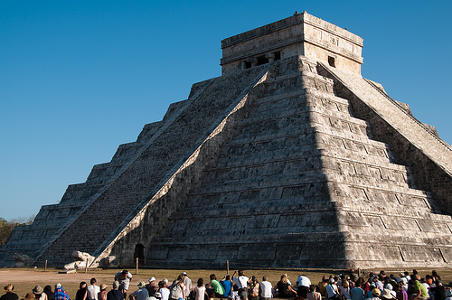
The main pyramid at the Maya site of Chichen Itza in the Yucatán Peninsula is the most popular site in Mexico for crowds to gather and celebrate the Spring Equinox (March 20-21). The Maya were accomplished astronomers and were able to accurately predict equinoxes, eclipses and other celestial events hundreds of years in advance.

Crowds gather to witness the serpent descend the pyramid
Crowds gather to witness the serpent descend the pyramid. Original upload by shawn_christie1970 (Flickr).

The main pyramid at Chichen Itza, known as the Pyramid of Kukulkan, has some unusual properties which researchers are still trying to explain. It is so precisely aligned that for a day or two either side of the Spring Equinox, the light falling on one side of the pyramid creates undulating shadows that look like a serpent slithering down the pyramid steps. The effect is best seen between 4 and 5 pm.

The slithering serpent is not the only surprise that the Pyramid of Kukulkan has in store for visitors. Kukulkan was a Mayan deity, the “feathered serpent”, more usually known in central Mexico as Quetzalcoatl. The Pyramid of Kukulkan is linked to the quetzal bird, because depictions of Kukulkan often show the distinctively long feathers of the quetzal. Standing in front of the pyramid and making a single hand clap results in an echo from the pyramid’s staircase, an echo which sounds like the downward chirp of a quetzal bird.

David Lubman has proposed that this may be the earliest sound recording so far discovered anywhere on the planet. We may never know whether it was originally accidental or intentional, but Lubman makes a strong case for this chirp being a deliberate representation of the call of the Respendant Quetzal bird, a bird described in Peterson and Chalif’s Field Guide to Mexican Birds as “the most spectacular bird in the New World.” Quetzal birds were sacred to the Maya, and their feathers were highly prized; the birds were formerly common in the rainforest which originally cloaked this entire region.

Sources

Original article on MexConnect.com: Did you know? Mayan architects built world’s oldest sound recordings

Lubman, David (1998) “Archaeological acoustic study of chirped echo from the Mayan pyramid at Chichen Itza, in the Yucatan Region of Mexico… Is this the world’s oldest known sound recording?“. Paper presented to the 136th Meeting of the Acoustical Society of America, October 1998.

Lubman, David (2002) “More on the Mayan Pyramid“. Article on the website of the Orange County Regional Chapter of the Acoustical Society of America:

Mexico takes on childhood obesity

 Mexico's geography in the Press  Comments Off on Mexico takes on childhood obesity
Mar 202011
 

As we noted in a previous post – Soft drinks, obesity, ,diabetes and public health in Mexico – Mexico has one of the highest obesity rates in the world, and public health officials are increasingly alarmed by the rapid rise in child and youth obesity. About one-third of children in Mexico are now classified as either overweight or obese.

A recent news article – Mexico puts its children on a diet – describes initial reactions to a new federal initiative which attempts to improve the diets of schoolchildren. School lunches are almost unheard of in Mexico, but almost all students have access to food during recess or on the way home, whether  organized by local parents, or from local stores or school vending machines.

The federal regulations to restrict the kinds of food available in schools met stiff opposition from some soft drinks and snack food manufacturers, who see youthful consumers as a guaranteed path to future success. Most fried foods have now been removed from schools, but the plethora of regulations still contains many anomalies.

The battle of student waistlines may have begun, but the war on childhood obesity is very far from over.

Mexico’s long romance with pearls began way before the arrival of Spanish explorers

 Other  Comments Off on Mexico’s long romance with pearls began way before the arrival of Spanish explorers
Mar 192011
 

This post highlights the pearl, the beautiful birthstone associated with the month of June. Few people realize that Mexico was once the world’s major source of pearls.

The history of pearl collecting in Mexico goes back a very long way. When Spanish explorers sailed into the Sea of Cortés (Gulf of California) in the early 1530s they encountered Pericú Indians wearing necklaces strung with red berries, shells and blackened pearls. It is believed that pearl jewelry in the region dates back about 7000 years. Lacking metal knives, the only way the Indians could prize open the oyster shells and find pearls was by throwing the shells into a fire, hence the charred pearls. The Spanish explorers quickly recognized that their knives would yield lustrous milky-white pearls, the equal in quality of any found in the Middle East or Asia.

Harvesting pearls became a priority as the Spaniards tried to establish permanent settlements on the arid peninsula now known as Baja California. From 1535 to Mexican independence in 1821, thousands of pearls were dispatched to Europe on a regular basis, where they were incorporated into the lavishly decorated regalia of many notable European courts. During the period of Jesuit missions in Baja (1697 to 1768) pearl collecting was restricted, but even then illegal traffic in pearls persisted.

Cover of Pearls, a natural history

Following Mexico’s independence, other European nations besides Spain sought access to Baja pearls. For instance, English traveler R. W. H. Hardy arrived in Mexico in 1825, to prospect for pearls and coral on behalf of the General Pearl and Coral Fishery Association of London. Hardy was proud of having “travelled over a part of Mexico visited by no other European” and greatly valued the local knowledge of the coastal Indians of north-western Mexico. Unlike most of his contemporaries, Hardy developed a very positive view of the Indians he met, and felt that they had far more to offer outsiders than just the location of natural resources.

The pearling industry in Baja really took off in the mid-nineteenth century as enterprising, business-minded armadores hired native divers (mainly Yaqui Indians from Sonora) to explore the numerous shallow coves between La Paz and Mulegé, and around the islands including Cerralvo and Isla Espíritu Santo. Diving was a seasonal occupation, primarily carried out during the warm months from May to late September. At other times of the year, water temperatures and higher winds made diving difficult or impossible. The Indian divers worked from rustic canoes for up to five hours a day, armed with a short sharpened stick which did double duty, to pry oyster shells off the seabed and to ward off lurking sharks and manta rays. The divers earned a share of the catch, but their rewards were meager and benefits few.

Citing a 1859 paper, Kunz and Stevenson report that by 1857, 95,000 tons of oysters had been removed from the Sea of Cortés, “yielding 2770 pounds of pearls, worth $5,540,000.” Mexico’s high society also lusted after pearls, leading Empress Carlota to remark how the ladies attending a theater event all wore dresses “covered in pearls”.

Mexico’s pearling industry was on the edge of world-wide fame. In a future post, we will see how the introduction of newer technology after 1870 revolutionized pearl collecting in Mexico, bringing a boom that would last well into the twentieth century.

Sources / Further reading:

  • Hardy, R. W. H. 1829 Travels in the Interior of Mexico in 1825, 1826, 1827 and 1828. London: Henry Colburn & Richard Bentley. Reprinted in 1977, Texas: Rio Grande Classics.
  • Kunz, G. F., and Stevenson, C. H. The Book of the Pearl: Its History, Art, Science and Industry. Dover. 2001.
  • Landman, Neil H and Mikkelsen, P. Pearls: A Natural History (Harry N. Abrams, 2001)
  • Mayo, C. M. Miraculous Air: Journey of a Thousand Miles through Baja California, the Other Mexico. Milkweed Editions. 2007.

This post is an edited version of the original article which appeared on MexConnect.

Consumer shopping habits and regions in Mexico

 Mexico's geography in the Press  Comments Off on Consumer shopping habits and regions in Mexico
Mar 172011
 

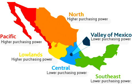
Nielsen, the world’s leading consumer information and research company (offices in more than 100 countries), recently analyzed the shopping habits of consumers in Mexico. From a geographical perspective, one of the most valuable aspects of the study is Nielsen’s use of consumer purchasing habits to suggest a division of Mexico into distinct shopping regions.

The market for consumer goods in Mexico is very large, and has grown rapidly since the 1980s. Mexico is now the world’s 11th most populous nation (112.3 million people in 2010) and has the world’s 11th largest economy. It is also the most populous Spanish-speaking country in the world. Mexico’s size and diversity result in great variations in consumer patterns from one area to another. To achieve maximum success, manufacturers, distributors and retailers in Mexico need to appreciate these regional differences.

Mexico's consumer regions

Mexico's consumer regions. Credit: Nielsen

As we have stressed in previous posts, Mexico has a marked north-south divide. Inhabitants in the north tend to be better-educated and live in smaller households, with higher household incomes and more purchasing power than their counterparts in southern Mexico. The Nielsen study broadly supports this division of wealth, but adds some refinements to the pattern.

The map summarizes Nielsen’s view of the pattern of Mexico’s consumer habits. Throughout the country, small traditional stores (defined by Nielsen as those stores where a salesperson or clerk must be present to serve shoppers) remain a vitally important option for consumer purchases.

Convenience stores and small supermarkets are most popular in Nielsen’s Pacific and North areas. Larger supermarkets are more important in the Valley of Mexico and in the Southeast region.

In all regions, traditional convenience stores are visited frequently, either daily or even twice-daily. Consumers typically visit the nearest supermarket twice a week, with Sunday being the single most popular shopping day. Mid-week supermarket shopping is most common in the Pacific, North and Southeast areas.

Related post:

Mexican migrant farmworkers in the USA

 Mexico's geography in the Press, Teaching ideas  Comments Off on Mexican migrant farmworkers in the USA
Mar 152011
 

The Economist (December 18-31, 2010) has a three-page article about migrant Mexican farmworkers, entitled “Fields of tears: they came to America illegally, for the best of reasons” (subscription required for web access).

This article is a great educational resource, offering dozens of possible debating points. It relates the adventures and misadventures of a young family from the state of Oaxaca, following them from their initial decision to leave for “El Norte” (USA) to their successive attempts to cross the border. They finally succeeded and “joined the vast undocumented workforce that undergirds America’s food supply”.

The Economist correspondent toiled alongside Mexican field workers as they picked strawberries in temperatures of up to 40 degrees C. (100 degrees F). The article goes on to consider the lifestyles of migrants, their access to services such as education and health care, and the degree to which they are welcomed by native-born Americans.

Looking at the life and motivation of a single family is a highly effective way of gaining familiarity with the multitude of issues related to the major flow of migrants from Mexico to the USA.

Previous posts related to Mexico-USA migration:

Migration between Mexico and the USA is the focus of chapter 25 of Geo-Mexico: the geography and dynamics of modern Mexico. Ask your library to buy a copy of this handy reference guide to all aspects of Mexico’s geography today! Better yet, order your own copy…

The purity of illicit drugs declines with distance from the Mexico-USA border

 Other  Comments Off on The purity of illicit drugs declines with distance from the Mexico-USA border
Mar 122011
 

The concept of distance decay is often used by geographers when trying to describe and explain spatial patterns.

Distance decay is the “attenuation of a pattern or process with distance” (Dictionary of Human Geography, Blackwell 1986). It is one of the fundamental concepts behind many geographic models (e.g. Christaller, von Thünen) and the basis of W. Tobler’s first law of geography: “everything is related to everything else, but near things are more related than distant things.” (Tobler 1970)

A recent study published in Addiction found that the principle of distance decay applies to the purity of drugs sold in the USA. Most drugs entering the USA do so via the Mexico-USA border. It presumably costs more, and entails higher risks, to transport drugs further north than just over the border.

The health risks associated with illicit, non-prescription drugs are related to drug purity. Addiction rates also vary with purity. Surprisingly, the geographic pattern of drug purity within a single country has rarely been investigated in detail before.

The researchers analyzed the drugs seized in about 240,000 drugs incidents for the period 1990-2004. They also looked at the correlation between drug purity and the time, and size, of each drug seizure.

The researchers found that the purity of methamphetamine, cocaine and heroin generally decreased with distance from the border. Beyond 1450 km (900 miles), however, heroin purity increased again towards the northeast. The pattern for heroin, and a similar pattern for methamphetamine after 2000, suggest that perhaps some of these drugs were imported via the eastern seaboard of the USA (heroin) or from southeastern Canada (methamphetamine). The findings also suggest that methamphetamine from Canada may be on a larger scale than previously thought.

For all three drugs, the purity of small amounts seized close to the border showed more variation than was true for seizures further north.

Given the conclusions of this study, researchers may be better able to predict the areas which are likely to have higher rates of drug dependence and overdoses.

And some people still think geography is boring?

Sources: Cunningham J.K., Maxwell J.C., Campollo O., Cunningham K.I., Liu L.M., Lin H.L.: “Proximity to the US-Mexico border: a key to explaining geographic variation in US methamphetamine, cocaine and heroin purity”. Addiction. 2 August 2010.

Tobler, W. 1970 “1970: a computer movie”. Economic Geography 46: 234-240.

Mexico’s population pyramid (age-sex diagram) for 2010

 Updates to Geo-Mexico  Comments Off on Mexico’s population pyramid (age-sex diagram) for 2010
Mar 102011
 

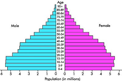
The population pyramid for Mexico in 2010 is shown below:

Mexico's population pyramid, 2010. Data: INEGI

What does this pyramid tell us about Mexico’s population and possible future trends?

The number of babies born during the last 20 years has been more or less equal for each 5-year period. This is despite a higher number of females in the age-bearing categories (15-45). These two statements, taken together, must imply that both birth rates (number of births/1,000 people) and fertility rates (number of children per female of child-bearing age) have fallen and continue to fall.

There are numerous implications for a population with a declining number of babies. Perhaps the most obvious is that fewer school places will be required in ten years time than are currently needed. In Mexico’s case, it is unlikely that school buildings will be closed (at least not in the short to mid-term) since many government-run schools currently house two independent school populations, one attending classes every morning, and the other attending classes in the afternoons.

The decline in babies also means that the average age of Mexico’s population continues to rise. The median age of Mexico’s 112.3 million inhabitants is now 26 years (i.e. half the population is older than 26 years, the other half is 26 years or younger).

Several chapters of Geo-Mexico: the geography and dynamics of modern Mexico discuss additional insights into Mexico’s population dynamics and trends, and their implications for future development. An earlier post here includes a link to a pdf file showing Mexico’s population pyramid in 1990, and the predicted pyramid for 2050. The 2050 pyramid shows just how fast Mexico’s population will age if present trends continue.

How sustainable is commercial fishing in northwest Mexico?

 Other  Comments Off on How sustainable is commercial fishing in northwest Mexico?
Mar 092011
 

Mexico’s fishing industry now accounts for only 0.24% of gross national product. The relatively shallow waters off the Pacific coast and abundance of plankton in waters cooled by the Californian current make for particularly good fishing in the north-west. Together, Sinaloa (23%) and Sonora (22%) account for about 45% of the national total. Fishing is also economically important in Veracruz (8%), Baja California Sur (6%), Campeche and Baja California (5% each) and Yucatán. Almost three quarters (72%) of the total annual catch of 1.5 million metric tons is landed at Pacific coast ports such as Guaymas, Mazatlán and Manzanillo. [excerpt from Geo-Mexico page 97]

A study of fisheries in the region by a team of researchers from the University of California San Diego’s Scripps Institution of Oceanography and the Centro para la Biodiversidad Marina y la Conservación in La Paz, Baja California Sur makes for interesting reading.

The team looked at fisheries data for northwest Mexico, defined as including the coasts of five states: Baja California, Baja California Sur, Sonora, Sinaloa and Nayarit. They conducted field research and then examined the connections between local fisheries data and the geography and habitats of the various fish species. They found a close tie between the geography of local habitats and the (local) decision as to which fish species to catch (clams, red snapper, shrimp). They also found that small-scale local fishing, which relies on thousands of pangas, remains an important component of local economies.

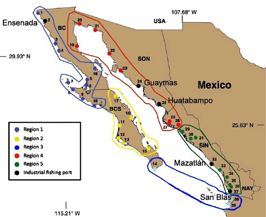
Proposed fishing regions in NW Mexico
Map of five proposed fishing regions in NW Mexico. Image credit:University of California-San Diego

The researchers concluded that the area is not one homogeneous unit, but can be best divided into five overlapping sub-zones (see map) differentiated on the basis of such characteristics as whether the coast is rocky or has mangroves, the presence of reefs or sandy seafloor, the coastal geology and latitude.

Hence, the current fisheries strategy of treating the entire region as a single area is not the most effective way to manage fisheries. According to the researchers, their five-fold zonation would allow “ecosystem-based management” in each sub-region. This would encourage management techniques which ensure long-term conservation of particular fish stocks and help increase fishing’s sustainability.

However, it also requires using different strategies for large-scale industrial fishing than for local, small-scale panga-based activity. The researchers remain optimistic that small-scale fishing has a good future, but only provided industrial-scale fishing is well monitored and controlled.

Source: University of California-San Diego (2011, January 27). Study finds common ground for ecosystems and fishing in Northwest Mexico. Retrieved January 28, 2011.

Plans for a tourism megaproject in Sinaloa, a Pacific Coast “Cancún”

 Mexico's geography in the Press  Comments Off on Plans for a tourism megaproject in Sinaloa, a Pacific Coast “Cancún”
Mar 072011
 

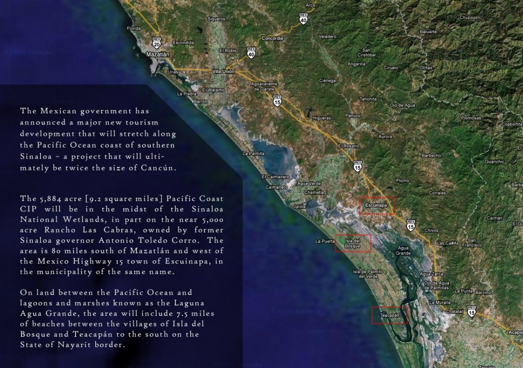
The National Fund for Tourism Infrastructure (renamed the National Tourism Development Fund, Fonatur, in 1974) began building Cancún in 1970 and Ixtapa in 1971, followed later by Los Cabos, Loreto and Huatulco. Fonatur has also started to develop a mega-project on a stretch of coastline north of Puerto Vallarta known as Riviera Nayarit.

Fonatur’s latest tourism mega-plan, first announced three years ago, is for a resort complex further north on the Pacific coast, in Escuinapa (Sinaloa), about 100 km south of the port city of Mazatlán. As for previous Fonatur purpose-built tourism resorts, Fonatur has prepared an overall land-use master plan, and will finance some of the initial basic infrastructure such as access highways and power lines. The hotels, recreational facilities, residential and commercial areas will be constructed by private developers.

Fonatur Sinaloa

Fonatur Sinaloa. Credit: La Punta Realty - Click to enlarge -

Fonatur Sinaloa is being planned as a “sustainable tourist development” targeting a wide cross-section of tourists by offering opportunities for sailing, spa visits, participatory sports, and a variety of cultural and educational activities. The Escuinapa site comprises 2,381 hectares (double the original area of Cancún) with 12 km of beachfront. The site is surrounded by the Sinaloa National Wetlands, and more than 20% of the area allocated to the resort is being set aside as a protected ecological reserve or conservation area.

The area (see image above from La Punta Realty) is quite easy to access by both highway and air. A divided toll highway goes all the way to the US border, and also connects the location to central Mexico via Tepic and Guadalajara. Two airports are within an hour of the new site: the local Teacapán airport, 26 km away, and Mazatlán International airport, 85 km away.

Fonatur’s business plan claims that the mega-resort will be able to accommodate 3 million tourists a year, with related annual expenditures of 2.8 billion dollars. The master plan for Fonatur Sinaloa envisages 15,000 hotel rooms, 25,000 condominiums, time-share rooms and tourist homes, as well as golf courses, a cruise-ship dock, shopping centers and cultural areas, intersected by interior canals linking the separate sections and creating a variety of aquatic zones.

The project will be developed in ten phases, with an estimated final completion date of 2019.

The pros and cons of floriculture in Mexico

 Other  Comments Off on The pros and cons of floriculture in Mexico
Mar 052011
 

In a previous post – Mexico’s flower power – we looked at the Mexico’s floriculture sector. Mexico’s immense biodiversity, one of the greatest on the planet, and its variety of climates have encouraged the cultivation of ornamental flowers, principally for the domestic market, but also for export. In this post, we present a summary of the pros, cons and impacts of floriculture in Mexico.

Advantages that Mexico has for floriculture:

  • large internal market
  • long tradition of growing ornamental flowers
  • rich biodiversity – Mexico has more than 30,000 species of flowering plants, one of the world’s most diverse floras
  • competitive labor costs
  • variety of climates, from tropical to temperature
  • relative proximity to the USA compared to other major flower producers

Disadvantages of/for floriculture

  • the required transport by air is expensive, and companies relying on third-party carriers may lose access to their export markets if the airline changes its scheduled routes. For example, Finca Argovia, a grower of exotic flowers in Chiapas (150 species, 7 million stems a year, including orchids and anthuriums) would suffer if flights from Tapachula to Mexico City were stopped. These flights are the essential first leg of Argovia’s access to international markets.
  • demand for flowers is highly seasonal and having perfect blooms available for certain specific days (such as Valentine’s Day, 14 February) is critical to a grower’s success.
  • flowers grown in open fields (the majority of Mexico’s ornamental flowers) are more susceptible to insect pests and weather-related hazards and damage than those grown in greenhouses.
  • representatives of flower growers’ organizations claim that they have to compete with “contraband” flowers that originate in Ecuador, Colombia, Costa Rica and the Netherlands, and are brought into Mexico from the USA.

Positive impacts of floriculture in Mexico

  • employment
  • export income
  • added aesthetic attraction (hotels, churches, restaurants, markets)

Negative impacts of floriculture in Mexico

  • runoff of agricultural chemicals into groundwater and local streams
  • many essential inputs (specialist pesticides, fertilizers, seeds, etc) have to be imported

For interest
Mexico’s national flower is the dahlia. To find out more, read this MexConnect article about Mexico’s national flower.

Overfishing in Mexico’s Sea of Cortés (Gulf of California)

 Excerpts from Geo-Mexico  Comments Off on Overfishing in Mexico’s Sea of Cortés (Gulf of California)
Mar 032011
 

The Sea of Cortés (Gulf of California) is one of the world’s top five seas in terms of ecological productivity and biological diversity. The region is world famous for its recreational sports fishing.

Background to the region’s wetlands

Among rivers feeding the Sea of Cortés are the Colorado, Fuerte and Yaqui. Its coast includes more than 300 estuaries and other wetlands, of which the delta of the Colorado River is especially important. The vast reduction in the Colorado’s flow has negatively impacted wetlands and fisheries.

These wetlands are also threatened by the development of marinas, resorts and aquaculture, especially shrimp farms. The plant and animal communities in these wetlands provide a constant supply of nutrients which support large numbers of fish and marine mammals. These include the humpback whale, California gray whale, blue whale, fin whale, sperm whale and the leatherback sea turtle.

Wetland degradation and declining fish stocks have had inevitable consequences on many marine mammals. Concern over endangered mammals such as the vaquita porpoise, which is endemic to the area and was being taken as by catch in gill nets, led to the establishment of the Biosphere Reserve of the Upper Gulf of California and Delta of the Colorado River in 1993.

The Biosphere Reserve aims to protect breeding grounds and conserve endangered species, including the vaquita, the totoaba, the desert pupfish and the Yuma clapper rail. This was the first marine reserve established in Mexico; several other marine protected areas has since been established on Mexico’s other coasts.

Did changes in technology hasten the decline of commercial fishing?

In the Sea of Cortés, changes in technology, coupled with high demand for fish (especially in Japan), and greed, help to explain the demise of fish stocks.

Commercial shrimp fishing started here in the 1940s. The introduction of outboard motors in the 1970s allowed small fiberglass boats (pangas) to travel further afield in search of fish. Up to 20,000 pangas using gill nets had an immediate adverse impact on fish stocks, with large decreases in roosterfish, yellowtail and sierra mackerel.

In the 1980s, as the sardine stocks close to Guaymas had been depleted, new sardine boats were built with refrigeration facilities which allowed them to catch sardines further offshore, in their feeding grounds near Midriff Island.

In the 1990s a longline fishing fleet began to operate out of Ensenada. Licensed boats were required to fish beyond a non-fishing zone extending 80 km (50 mi) from the coast. A single longline boat may have 5 km (3 mi) of line with 600 to 700 baited hooks in total. The swordfish populations outside the protected zone were quickly depleted, leading fishing boat owners to apply for permits to catch shark inside the 80-km limits.

The Sea of Cortés faces numerous pressures. Decades of commercial overfishing are causing a total collapse of fish stocks. As late as 1993, the area, less than 5% of all Mexico’s territorial waters, produced about 75% of the nation’s total fish catch of 1.5 million metric tons; however, by some estimates, fish populations have declined by 90% since.

What are the solutions?

Reversing decades of overfishing requires more effective enforcement of fishing regulations, especially the 80-km zone of no commercial fishing; vessel monitoring systems; a ban on the use of gill nets; and a prohibition on the catch of certain fish such as bluefin tuna.

Fish farming may be a viable alternative and several commercial tuna farms, where wild tuna are raised in near-shore pens, have been established in Baja California but more research on the ecological pros and cons of establishing such farms is urgently needed.

In our next post, we will take a closer look at some recent research connected to the restoration of fish stocks in this region.

Fishing in Mexico is analyzed in chapter 15 of Geo-Mexico: the geography and dynamics of modern Mexico. Ask your library to buy a copy of this handy reference guide to all aspects of Mexico’s geography today! Better yet, order your own copy…

Mexico’s flower power…

 Other  Comments Off on Mexico’s flower power…
Mar 022011
 

Given its diversity of climates and immensely varied natural flora (see Mexico’s mega-biodiversity, Mexico is ideally suited for commercial floriculture (flower growing).

Helped by government support, floriculture expanded rapidly in the 1980s and 1990s. About 14,000 hectares of agricultural land are devoted to ornamental flowers, with 10,000 growers concentrating on 50 different varieties, the most important of which are gladioli, roses, chrysanthemums, carnations, birds-of-paradise and the nard. Mexico’s flower growers produce 83,000 tons/yr of flowers, 80% of them destined for the domestic market. Most flower farms are smallholdings of 1-3 hectares in size, though there are also about 150 high-tech, greenhouse-based operations for the export market.

In addition to the area dedicated to ornamental flowers, a further 9,000 hectares are devoted to plants and flowers used in the cosmetics and food flavoring industries.

The state of Mexico has the largest area devoted to floriculture in the country, centered on Villa Guerrero. Other states important for ornamental flowers are Baja California, Coahuila, Colima, Chiapas, Guanajuato, Guerrero, Jalisco, Michoacán, Morelos, Puebla, Querétaro, Tabasco, Veracruz, and, in the last five years, Yucatán.

The internal market for ornamentals is severely constricted by a lack of space in Mexico City’s wholesale market; the resulting congestion results in about 20% of all the fresh flowers arriving daily at the market having to be destroyed.

Mexico’s nationwide production of flowers is worth about 1 billion dollars a year. Only a small percentage of production is exported, mainly to the USA, with smaller amounts to Canada and Europe. While Mexican flower exports are currently worth some 50 million dollars, exports from Columbia are worth 550 million dollars and those from Ecuador and Costa Rica about 150 million.

Related posts:

The history and scope of geography

 Books and resources  Comments Off on The history and scope of geography
Mar 012011
 

Dr Jerome Dobson, who led the Bowman Expedition to Mexico, gave the 2010 Jefferson Science Lecture to the US Department of State on “Geography: Use It Or Lose It“:

  • Full text of Geography: Use It Or Lose It” with link to video was at http://www.state.gov/e/stas/series/154218.htm [March 2011]

This lecture ranges widely across the history and scope of geography (primarily in the USA) and  is a very interesting read, as is Dobson’s earlier 2-part article in ArcNews:

(Thanks go to Dr. Joseph Kerski, Esri’s Education Manager, for suggesting the links to Dobson’s lectures.)

Geography research in Oaxaca funded by the US military stirred up a storm of protest

 Other, Teaching ideas  Comments Off on Geography research in Oaxaca funded by the US military stirred up a storm of protest
Feb 282011
 

In 2005, a geography research project known as México Indígena, based at the University of Kansas, received 500,000 dollars in funding from the US Defence Department to map indigenous villages in two remote parts of Mexico, in collaboration with the Autonomous University of San Luis Potosí , Radiance Technologies (USA), SEMARNAT (Mexico’s federal environmental secretariat) and partnered with the US Foreign Military Studies Office (FMSO).

Under some circumstances, this might not be a huge problem. After all, the large-scale survey maps of many countries were developed primarily by military engineers with military funding, in the interests of national security. In the past, several countries, including France and the UK, extended their map-making to cover their colonies or dependent territories.

What sets México Indígena apart is that, between 2005 and 2008, under the guise of “community participatory mapping”, US researchers, funded by the US military, collected detailed topographic, economic and land tenure information for several villages in Mexico, an autonomous nation, whose people have long viewed their northern neighbors with considerable suspicion. After all, in the mid-19th century, the USA gained a large portion of Mexico’s territory.

The indigenous villages mapped were in the Huasteca region of San Luis Potosí, and in the Zapotec highlands of Oaxaca, the most culturally diverse state in Mexico. The villages mapped in Oaxaca included San Juan Yagila and San Miguel Tiltepec.

México Indígena is part of a larger mapping project, the Bowman Expeditions. In the words of the México Indígena website:

“The First Bowman Expedition of the American Geographical Society (AGS) was developed in Mexico…  The AGS Bowman Expeditions Program is based on the belief that geographical understanding is essential for maintaining peace, resolving conflicts, and providing humanitarian assistance worldwide.”

“The prototype project in Mexico is producing a multi-scale GIS database and digital regional geography, using participatory research mapping (PRM) and GIS, aiming at developing a digital regional geography, or so-called “digital human terrain,” of indigenous peoples of the country.”

Mexico’s indigenous communities are the poorest in the country, beset by poverty, poor access to education and health care, and limited economic opportunities. Among the common concerns voiced by protesters against the mapping project were that the information collected could be used for:

  1. Counter-insurgency operations
  2. Identification and subsequent acquisition of resources
  3. Biopiracy

Despite attempts at clarification by the project leaders, some communities remain upset, claiming that they were not made aware of the US military’s funding, and have demanded that all research findings either be returned to the community or destroyed (see, for example, this open letter from community leaders in San Miguel Tiltepec).

Choose the conclusion you prefer:

1. Mexico’s indigenous peoples face enough challenges already. Their best way forward is if US military funding for mapping beats a hasty retreat, or

2. Mexico’s indigenous peoples face enough challenges already. Their best way forward is to welcome and embrace offers of help from outside their community.

Further reading/viewing:

The México Indígena controversy is the subject of a short film entitled, “The Demarest Factor: US Military Mapping of Indigenous Communities in Oaxaca, Mexico”. The film investigates the role of Lt. Col. Geoffrey B. Demarest ( a US Army School of the America’s graduate) and the true nature of the mapping project. It discusses parallels between US political and economic interests within the North American Free Trade Agreement (NAFTA) and a US military strategy designed to secure those very interests.

Things to think about:

  • Should academic research in foreign countries ever be funded from military sources?
  • Does the right of self-determination mean that indigenous peoples can refuse to cooperate with academic researchers, even when the research may bring benefits to the community?
  • Should researchers ever be allowed to collect information from a community without the community’s express consent?

The irony about the choice of “Bowman” for the AGS research expeditions.

Isaiah Bowman (1878-1950), born in Canada, was a US geographer who taught at Yale from 1905 to 1915. He became Director of the AGS in 1916, a position he only relinquished when appointed president of Johns Hopkins University in 1935. He served as President Woodrow Wilson’s chief territorial adviser at the Versailles conference in 1919. Bowman’s best known work is “The New World: Problems in Political Geography” (1921). His career has been subject to considerable scrutiny by a number of geographers including Geoffrey Martin (The life and thought of Isaiah Bowman, published in 1980) and Neil Smith who, in American Empire: Roosevelt’s Geographer and the Prelude to Globalization (2003) labels Bowman an imperialist, precisely the claim made by many of its opponents about the México Indígena mapping project.

The changing geography of drug trafficking routes in Mexico

 Mexico's geography in the Press  Comments Off on The changing geography of drug trafficking routes in Mexico
Feb 262011
 

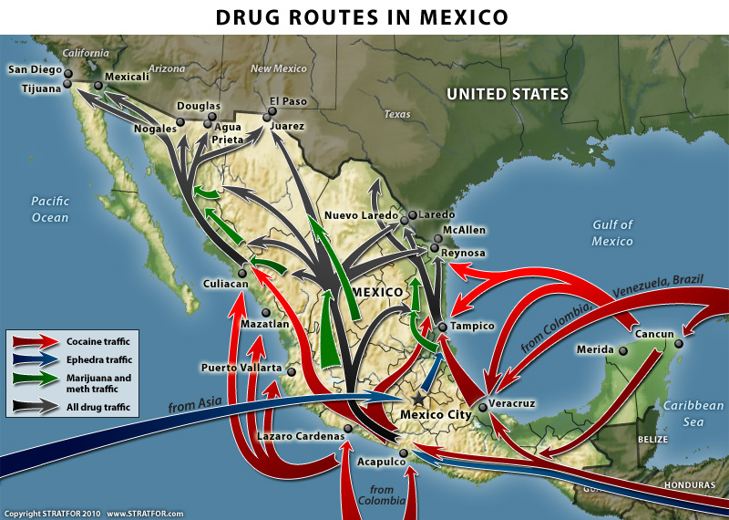
Last year, we reproduced an earlier version of this Stratfor map in The geography of drug trafficking in Mexico. The recently released new version, shown below, shows several changes from the earlier version.

Drug routes through Mexico

Drug routes in Mexico. Copyright Stratfor. Click map for enlarged version.

Map © Copyright 2010 Strategic Forecasting Inc, STRATFOR www.stratfor.com. This map is republished with permission of STRATFOR.

The main changes are that the new map:

  • does not show the territories controlled by each of the major drug cartels. As we have noted previously, the boundaries between cartel territories are hotly disputed and in a constant state of flux.
  • shows more marijuana traffic originating from Jalisco and Michoacán states.
  • labels the importing of ephedra from Asia as coming “from China”
  • adds a new route for ephedra trafficking from Central America through Guatemala and along Mexico’s Pacific Coast towards Acapulco.
  • strengthens the arrows showing a much larger movement of “all drug traffic” northwards from central Mexico through Chihuahua state and towards the border city of Ciudad Juárez, with branches of this flow extending not just to the Pacific Coast (as in the old map) but also to the Gulf Coast.

What do these changes mean?

First, it is apparent that the overall pattern of drug trafficking routes is more complex than originally thought. Shifting alliances between trafficking groups means that the “map” is being constantly redrawn to reflect the changing relative strengths of the different cartels and drug gangs.

These shifts in routes, and in the zones at the margins of each cartel’s territory mean that the focus of drug-related violence in Mexico is not limited to fixed locations, but that virtually anywhere in the country could find itself “in the wrong place at the wrong time” at some point in the future.

This is quite different to the pattern of drug-related violence 30 or 40 years ago, when most of the problems were concentrated in a relatively small number of generally isolated areas where the drugs were actually grown.

To read more posts about the geography of narcotic drugs in Mexico, use the “drugs” tag in the navigation bar on the left hand side of each page.

Other relevant link

Geo-Mexico: the geography and dynamics of modern Mexico discusses drug trafficking in several chapters.  A text box in chapter 20 looks at the drug trafficking business and efforts to control it.  Buy your copy today to have a handy reference guide to all major aspects of Mexico’s geography!

Feb 242011
 

Mexico is the world’s seventh largest coffee producer and one of the leading suppliers of organic, shade-grown coffee. The nation’s 480,000 coffee growers, most working small parcels of land less than 5 hectares (12 acres) in size, are concentrated in Chiapas, Veracruz and Oaxaca, and produce 268,000 metric tons a year. While Mexican coffee consumption per person is rising, 62% of the harvest is exported, bringing in $400 million annually.

This year’s crop escaped the deep freeze in late January and early February that decimated corn, tomatoes, bell peppers and other crops in northern Mexico, but unseasonal rains and cold weather in coffee-growing regions of southern and eastern Mexico have reduced coffee yields and mean that this season’s crop is also ripening unevenly. Some growers are worried that this could be the worst coffee harvest in almost 20 years.

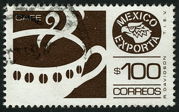
Mexico's exports: coffee

Coffee, one of Mexico's most important agricultural exports

With fewer berries on each plant, the potential earnings for coffee-pickers are poor, since it takes longer to fill each basket with ripe berries. Some experienced coffee pickers are looking for alternative employment hoping for better pay. According to growers, the less experienced pickers remaining on the job are causing more damage to the bushes than normal, because they employ a hand picking method known as “ordeñando” (milking) in which they run their hands rapidly along a branch, stripping away the leaves as well as the beans. The problem for growers is that this technique reduces the following year’s crop.

The 2010-2011 harvest season began in October. Government officials are still estimating a harvest of 4.4 million 60-kg sacks, which would be a total of about 264,000 metric tons. However, Agroindustrias Unidas de México, Mexico’s largest coffee exporter, believes that 3.5 million sacks will be nearer the truth. If the exporter is correct, the current harvest would be only marginally better than Mexico’s 1992-1993 harvest which was the lowest in the past twenty years.

The only silver lining in this cloud is that coffee prices on international markets are high and rising, mainly due to problems in Colombia, so Mexican growers have a good incentive to pick every single ripe berry they can find.

Feb 222011
 

The Baja California peninsula is one of the most arid areas in Mexico and water shortages are becoming critical, especially along the southern coastline which has matured into one of the most desirable jet-set locations in the world.

Desalination, which involves removing the salts from seawater or brackish water to provide drinking water, is one viable option to ensure future water security for the region. There are already about 70 desalination plants on the Peninsula, though most are very small (25 liters/second or less) and are powered by conventional electricity. Several larger desalination projects on the Baja California Peninsula, some of which will rely mainly on solar power, are currently in the planning stages.

Map of Baja California PeninsulaLa Paz, the capital of the state of Baja California Sur, faces a particularly serious water supply problem. The local aquifer is reported to be already overexploited and suffering from salt water intrusions. Because of its greater density, seawater normally underlies freshwater in coastal areas. Salt water intrusions occur when so much fresh water is pumped out of coastal aquifers that it is replaced by the underlying salt water. The water supply issues have led to water rationing, in which almost half of La Paz’s 250,000 residents receive water only 12 hours or less each day.

Obtaining water from the desalinization of sea water is more expensive than abstracting water from aquifers via wells, but avoids the possibility of salt water intrusions.

A recent Ooska news article provides details of the desalination plants already built or being planned:

Baja California Sur:

Cabo San Lucas, opened in 2007, treats approximately 230 liters a second (60 gallons/s), equivalent to 20 million liters (5 million gallons) a day.

La Paz. Still at the proposal stage is a desalination plant capable of treating 200 liters a second.

Sierra de la Laguna. A Canadian mining company (Vista Gold Corp.) planned a desalination plant to provide water for its proposed Concordia open-pit mine. However, the mining plan was refused an essential permit by the Mexican government.

Baja California:

Ensenada. The 28-million-dollar El Salitral desalination plant is a “highly innovative project that would put the region on the map globally for desalination”. Construction is due to start later this year, and the plant should be operational by the end of 2012, when it will treat 250 liters of seawater a second. The plant would supply 96,000 people with potable water.

Rosarito. Preliminary geological and environmental impact studies are underway for a desalination facility in La Misión large enough to supply the needs of 96,000 people. Still in the concept stage is a second desalination plant  which would supply water across the border to San Diego in California.

San Quintín. Plans exist for a desalination plant with a capacity of 150 liters a second.

Main source: The OOSKA News Weekly Water Report for Latin America and the Caribbean (16 February 2011)

Want to read more?

Cold weather wreaks havoc on crops in Sinaloa, Mexico

 Mexico's geography in the Press  Comments Off on Cold weather wreaks havoc on crops in Sinaloa, Mexico
Feb 212011
 

Corn production has been the core of Mexican agriculture throughout its history, and continues to be very important. Production has increased by more than 40% since 2000. Currently corn is grown on about half of all agricultural land. However, corn is a rather low value crop and accounts for only about 14% of total crop value.

Corn, for both human and livestock consumption, is grown virtually everywhere in Mexico and is the leading crop in 17 of the 32 states. The leader in volume of corn produced is Sinaloa with 28% of the national total. Other major corn states are Jalisco (12%), State of Mexico (6%), Michoacán, Guanajuato and Guerrero (5% each).

The unusually cold weather in early February 2011 hit farming areas in northern Mexico particularly hard. Farmers in Sinaloa, the “Bread Basket of Mexico,” report that 300,000 hectares (750,000 acres) of corn were destroyed after unusually cold temperatures in the first few weeks of the year. A further 300,000 hectares suffered some damage. Sinaloa has 470,000 hectares of farmland devoted to the white corn used to make tortillas; 90% of this area has been damaged. Heriberto Felix Guerra, federal Secretary for Social Development (SEDESOL) called the weather-related losses the worst disaster in Sinaloa’s history. The economic loss could exceed three billion dollars.

The federal Agriculture Secretariat is rushing urgent aid to farmers, including tax breaks and low-interest loans for seed, in the hopes that many of them can replant their corn crop while there is still time. As of today, more than 130,000 hectares of corn in Sinaloa have already been replanted. The aim is to reseed between 200,000 and 300,000 ha (500,000-750,000 acres) of corn, for an eventual harvest (in Sinaloa) of 3 million metric tons of corn. The reseeding must be completed by 10 March as, after that date, there are too few “growing days” to guarantee a harvest. Average yields in Sinaloa for white corn are expected to fall from their usual 10 tons/ha to around 7 tons/ha this year.

Mexico has an annual shortfall in corn production and always has to import some corn (mainly from the USA and South Africa) to meet total domestic demand. This year, the government is considering raising its usual import quotas to ensure ample supplies of corn (and tortillas) for the coming year. Corn prices have already shot up; Mexico’s imports are going to cost a lot more than in recent years.

Citrus orchards, tomato crops and other vegetables were also decimated. Tomatoes are by far the most important horticultural crop in Sinaloa, but other crops affected include green beans, squash and chiles. It will be another 6 weeks to 2 months before another tomato harvest is possible. The price of tomatoes also rose immediately and could double, at least temporarily, within the next few weeks.

The Mexican tomato crop is mainly the larger Roma variety which is widely used in the fast food industry. Already at least one fast-food chain in the USA is adding tomato slices to hamburgers only on request; the smaller tomatoes used in salads are not affected by the recent cold snap.

Previous related posts:

Review of Geo-Mexico by Geographic Travels

 Reviews of Geo-Mexico  Comments Off on Review of Geo-Mexico by Geographic Travels
Feb 202011
 

Geographic Travels is one of the web’s most popular and long-established geography blogs. Here is what they had to say about Geo-Mexico:

Book Review: Geo-Mexico

Earlier we featured the great blog, that is still active, Geo-Mexico. The blog Geo-Mexico is a promotion blog for the book, also called Geo-Mexico. We received a review copy of the book and can honestly say the book more than lives up to the blog.

As a child growing up in the center of the United States I knew Mexico was 1) the source of many immigrants 2) the land of tacos and 3) home of advanced American Indian nations. Later on I became more and more interested in Mexico because of its advancement into multiparty democracy, its rich Catholic tradition, and complex mixture of cultures. Because of my growing interest the book Geo-Mexico was a great read for me.

The book is authored by Dr. Richard Rhoda and Tony Burton. Both of these men are experts on Mexico. Their book proves their expertise. Written in textbook form Geo-Mexico covers the whole range of the geography of Mexico. The chapters covers Poctepec (“hill that smokes” or physical geography), Michmaloyan (“place to fish” or economic geography), and Teocalcingo (“where the temple is” or human geography). Thirty-one chapters cover the full range included in these three subfields. Whether one wants to read about the rise of Protestantism in Mexico, the stark north-south political divide between Right and Left, or water issues throughout the country this is the book to read.

Catholicgauzette greatly appreciated the professional, easy-to-read maps. Though the maps are in black and white this is not an issue because of the smart use of different fill designs.

Geo-Mexico is fragmented into a text book style which allows one to jump to the chapter of interest without fear of missing out. However, it does help if you read related chapters like “Migration to the USA” and “Mexicans in the USA.”

Geo-Mexico is a great read. To quote myself during the first day of high school Spanish, Me gusta

Geographic Travels, April 12, 2010

– – – – –

Six months on, one of the authors of Geographic Travels kindly sent us this short note:

It truly is a great book.  When I was back stateside there would be slow nights were I would take it off the bookshelf, open to a random chapter, and just read.  I like how you combined the textbook format with general readability.”

Feb 192011
 

Tomatoes are one of the many native Mexican plants that have become essential ingredients in the cuisine of many countries. Mexico is the 10th largest tomato producer in the world, after China, USA, India, Turkey, Egypt, Italy, Iran, Brazil and Spain (FAO 2008).

Mexico produces both red tomatoes (tomate or jitomate, depending on the region) which have high yields and account for about 75% of total tomato production, and green tomatoes (tomate verde) which have a lower yield and account for the remaining 25% of production.

The statistics in this post apply to the production and export of red tomatoes only.

The main varieties of red tomatoes in Mexico are:

  • vine-ripe large rounds
  • cherry tomatoes
  • Roma tomatoes, which now account for 54% of all tomato plantings in Mexico, as demand for them has increased at the expense of other kinds
  • greenhouse tomatoes (the collective name for several other varieties)

Greenhouses

The single most significant trend in tomato growing in Mexico is the increasing volume of production coming from greenhouse (including shade house) cultivation. Greenhouse cultivation still represents only a small portion of total tomato production in Mexico, but results in greatly improved yields.

Mexico has around 3,200 hectares of horticultural greenhouses in total. An earlier post analyzed the essential characteristics and advantages of the production of horticultural products in greenhouses.

The major advantages for tomato production are:

  • helps to raise yields
  • enables producers to move away from seasonal production and grow tomatoes virtually the entire year
  • ensures a higher quality and consistency of product
  • facilitates better food safety
  • helps to ensure that production and packing plants meet or exceed international standards

Rising yields

Yields are rising. Open field yields have risen from 23 metric tons/ha in 1990 to 28 mt/ha in 2000 and to 39 mt/ha in 2010. The highest open field yields are about 45 mt/h in Baja California and Sinaloa, due in part to their efficient pest and disease control protocols.

Greenhouse cultivation of tomatoes gets much higher yields, but also requires more capital investment and more expensive inputs of labor, fertilizers and pesticides. Open field cultivation of tomatoes in Sinaloa and Baja California costs between $3,800 and $6,000/ha. Greenhouse and shade house production of tomatoes can cost up to $22,000/ha. (All figures in US dollars.) The costs associated with many imported inputs (agrochemicals, seeds and fertilizers) are high; they are also dependent on the peso/dollar exchange rate.

Greenhouse yields in Mexico are generally about 150-200 mt/ha. Tomato growers in the USA and Canada using greenhouses achieve yields of up to 450mt/ha, so Mexican producers still have plenty of room for continued improvement.

The largest area of greenhouse tomato cultivation is in Spain (20,000 hectares). By comparison, the USA has only around 350 ha of greenhouse tomatoes, Canada has 650 ha and Mexico 730 ha.

Area cultivated and volume of production

The total area (greenhouse and open field) devoted to tomato cultivation in Mexico has decreased in recent years, from 85,000 ha in 1990 to about 60,000 in 2010.

Tomato production in Mexico for the 2010/11 season is forecast to reach 2.2 million metric tons.

Seasonality

There are two major seasons:

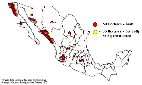
1. In the winter season (October-May), growers in Sinaloa are the main producers and exporters of fresh tomatoes. Michoacán, Jalisco, and Baja California Sur also produce significant amounts in the winter season. Sinaloa growers have adopted very modern cultivation methods, selecting varieties with an improved and extended shelf life, employing highly efficient drip irrigation, and using plastic mulch to maintain their high yields. Sinaloa has 15,000 hectares devoted to tomatoes, of which 1,340 hectares are using greenhouses or shade houses.

2. During the summer season (May-October), growers in Baja California are the main producers and exporters of fresh tomatoes, along with growers in Michoacán, Jalisco, and Morelos.
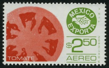
Tomatoes on a stamp

Mexico Exports: Tomatoes

Domestic consumption and the export market

The final consumption figure for the domestic market depends largely on the volume of tomato exports (primarily to the USA), since domestic consumption is essentially restricted to those tomatoes that do not enter the export flow. Volumes of exports, and price/ton depend on numerous factors beyond the control of farmers in Mexico, including, for example, the seasonal weather in Florida which will help determine the volume of tomatoes produced in the USA.

The USA imports tomatoes from both Canada and Mexico. Mexico’s share of USA tomato imports has risen rapidly since 2000 on account of their lower costs. Mexican tomatoes are less expensive for USA buyers than their Dutch or Canadian counterparts, due to Mexico’s cheaper labor rates, lower transport costs, and their modern cultivation and packing systems.

Mexico’s 1.1 million tons a year of tomato exports are worth 1.1 billion dollars. Mexico does import some tomatoes, but the annual value of imports rarely exceeds 65 million dollars.

Potential risks faced by Mexico’s tomato growers

  • extreme heat may make tomatoes ripen earlier than usual, as happened in Sinaloa in December 2009
  • the switch from open field tomato production to protected production (in greenhouses or shade houses) requires an expensive investment in infrastructure and technology.
  • international prices each year are a major determinant of how many hectares of tomatoes are planted the following year

Note on the first GM tomato

The first GM tomato to be commercially cultivated was the Flavor Saver from the Calgene company, planted in 1995 in Mexico, California and Florida. It was marketed as the MacGregor tomato. It was primarily developed because it did not spoil as quickly as previous varieties of tomato. MacGregor tomatoes last at least 18 days without spoiling, from the time they are picked. Conveniently, consumers also preferred their taste to then-existing varieties. Developing the first GM tomato cost Calgene 25 million dollars and took 5 years.

Main source:

Flores, D and Ford, M. Tomato Annual: area planted down but production up. USDA Foreign Agricultural Service GAIN (Global Agricultural Information Network) Report, January 2010

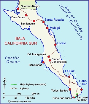
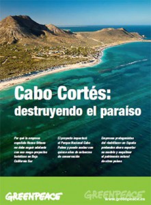
The ten states in Mexico with the lowest population density

 Other, Teaching ideas  Comments Off on The ten states in Mexico with the lowest population density
Feb 172011
 

In a previous post we looked at “The ten states in Mexico with the highest population density“. At the end of that post, we suggested that you try to guess which 10 states in Mexico have the lowest population density. In this post, we look at the answer!

Below is a table showing the 10 states in Mexico with the lowest population density.

RankStatePopulation density (people/sq.km)
1Baja California Sur8.6
2Durango13.2
3Chihuahua13.7
4Campeche14.3
5Sonora14.7
6Coahuila 18.1
7Zacatecas19.8
8Quintana Roo29.9
9Nayarit38.9
10Oaxaca40.6

You probably got many of the answers right, since several of the states in the table are among Mexico’s largest states in terms of area. In fact, Mexico’s five largest states (Chihuahua, Sonora, Coahuila, Durango and Oaxaca, are all on the list. However, there are some surprises. For example, both Nayarit and Campeche are smaller than the average Mexican state. Why might this be so? Large parts of each state currently have very few residents. Much of Nayarit is either mountainous terrain or swampy, coastal wetland. A large part of Campeche is sparsely peopled tropical evergreen forest (tropical rainforest).

To conclude this brief look at population density, here is a map showing the population density of all Mexico’s 32 states. [For simplicity, we count the Federal District as a state.]

Population density map
Mexico’s population density in 2010

Several chapters of Geo-Mexico: the geography and dynamics of modern Mexico discuss population issues, including population distribution and population density. Buy your copy today to have a handy reference guide to all major aspects of Mexico’s geography!

Feb 162011
 

The commercial greenhouse production of horticultural crops in Mexico started in the 1950s, with floriculture (flower-growing) operations. It then expanded to include some vegetables in the 1980s. During the 1990s, larger, more modern greenhouses were introduced specializing in the growing of vegetables for export markets.

In 1991, Mexico had only 51 hectares of vegetable production in greenhouses. The signing of NAFTA in 1994 stimulated increased investment in Mexico from Israel, Holland, and Spain in greenhouse systems designed to boost vegetable production for the US market.

The area of greenhouses has risen rapidly since then to about 2,400 hectares in 2009, almost double the area recorded for 2005, and including 1,000 hectares devoted to flowers.

What are the advantages of production using greenhouses?

  • possible to control the environment
  • enables a higher quality of product, suitable for international markets
  • improves food safety
  • allows growers to have a tighter control on water quality
  • enables farmers to supply winter markets when fresh food prices are at a premium
  • avoids or offsets weather-related problems, such as cold spells or heavy rain
  • allows farmers to perfect crop timing to match times of highest prices
  • avoids some open-field issues such as weeds and insect pests
  • takes advantage of Mexico’s long days and many hours of strong sunlight

What are the disadvantages of production using greenhouses?

  • construction costs
  • costs to install necessary infrastructure, such as water supply
  • cost of energy required to heat greenhouse in the event that sunshine is insufficient
  • nearby residents may object to the unsightly view of hectares of greenhouses

Protected horticultural areas in Mexico

Protected agricultural areas in Mexico (greenhouses and shade houses), 2007. Source: Mexican Association of Protected Horticulture

Where are most of Mexico’s greenhouses located?

Vegetable greenhouse production is highly developed in five states (see map):

  • Sinaloa (26.3% of Mexico’s total production of greenhouse vegetables)
  • Baja California Sur (13.5%) -NB this state’s protected area has increased sharply since 2007, the date of the map
  • Baja California (9.5%)
  • Jalisco (7.4%)
  • Sonora (6.9%).

Combined, these five represent 84% of the total greenhouse production of vegetables.

By area planted, the major crops produced in greenhouses in Mexico are:

  • tomatoes (60% of the total)
  • cucumbers (20%)
  • chiles (10%)

One clear trend is that the area of all these crops is expanding very rapidly. For instance, from 2007 to 2008, the area devoted to the greenhouse production of tomatoes rose 19%, while chiles and cucumbers rose 35% and 29% respectively.

95% of Mexico’s greenhouses are plastic, rather than glass, mainly because the extra insulation afforded by glass is not required in most parts of Mexico given the climate. Many greenhouses are now made in Mexico, but others are imported from Israel, Canada, the Netherlands, Spain, France and the USA. Many of the greenhouses are high-roofed, between 4 and 5 meters tall.

A basic greenhouse structure covering 1 hectare (2.4 acres) costs about $160,000, excluding the cost of any irrigation system. Because financing is difficult to obtain in Mexico, many producers rely on relatively low-cost plastic greenhouses, which do not usually have any heating systems. Some newer models have hot water or gas heating systems which guarantee that crops can be timed to coincide with peak demand during the US winter.

In an effort to hasten the adoption of improved horticultural technology, the Agriculture Secretariat (SAGARPA) has started a shared-risk fund to encourage greenhouse installation, provided it is to grow crops other than tomatoes, including herbs, chiles and lettuce.

Besides initial costs, another major constraint on the expansion of greenhouse systems in Mexico is distance from the main markets north of the border. From some areas, reaching markets in California requires a 36-hour truck ride. Any delay means that the crop will not arrive in optimum condition.

Another limitation which restricts the universal adoption of greenhouses is that they generally need a good supply of water. This is not always easy (or cheap) to obtain, especially in arid areas such as Baja California.

Finally, as with most farmers, greenhouse operators in Mexico face competition from growers in other countries, and also have to contend with market volatility (whether real or perceived).

Sources:

Lopez, J. and K. Shwedel. 2001. The Mexican greenhouse vegetable industry. Industry Note 032-2001, 5 pp.

Cantliffe, D and Vansickle, J. Mexican Competition: Now from the Greenhouse. http://hos.ufl.edu/protectedag/pdf/MexicanGHindustry.pdf [accessed 22 January 2011]

Flores, D and Ford, M. Greenhouse and Shade House Production to Continue Increasing. USDA GAIN report, 22 April 2010. [accessed via link at http://www.freshplaza.com/news_detail.asp?id=62580; accessed 27 January 2011]

Feb 142011
 

The January 2011 issue of Scientific American contains “Casualties of Climate Change” which takes an in-depth look at three case studies (Mozambique, Mekong Delta and Mexico) where (according to the authors) climate-forced migrations will be inevitable in the next 70 years.

The article combines research which formed part of the European Commission’s Environmental Change and Forced Migration Scenarios project (EACH-FOR), a global study on environmentally induced migration, with maps produced by the Center for International Earth Science Information Network (CIESIN) at Columbia’s Earth Institute.

In the case of Mexico, the case study suggests that the declining rainfalls and decreasing water availability resulting from climate change will lead to more frequent and more prolonged droughts, especially in central and western Mexico, alongside an increase in the frequency and severity of tropical storms and hurricanes. The authors cite evidence from interviews in the state of Tlaxcala that some climate-induced migration is already under way, as rainfall totals and timing have become less predictable.

Of course, predicting what the climate in Mexico (and elsewhere) will be like in 2080 is a decidedly risky undertaking. At best, such predictions are a statistical guesstimate. Even so, it is still useful to consider alternative climate change scenarios, together with their likely impacts on  environmental hazards and future movements of people. Looking at the alternatives may allow the development of strategies and policies which can reduce or minimize the adverse  social, human, economic and environmental impacts.

Four colorful maps accompany the Mexico case study:

  • population density
  • rain-fed agricultural land
  • incidence of drought
  • predicted change in runoff.

The downside: In some instances, data given in the text appears to conflict with the data shown on these maps. Furthermore, no definition for “drought” is offered in either the text or the relevant map. The drought map’s categories are stated to be “percent of growing season that experienced drought, 1988-2007) but some methodological clarification of the underlying assumptions made and how these figures were calculated would have greatly enhanced the map’s value.

Previous posts about climate change in Mexico:

Mexico’s environmental trends and issues are examined in chapter 30 of Geo-Mexico: the geography and dynamics of modern Mexico. Ask your library to buy a copy of this handy reference guide to all aspects of Mexico’s geography today! Better yet, purchase your own copy…