Mexican clothing and culture exhibition at the Royal Ontario Museum, Toronto

 Other  Comments Off on Mexican clothing and culture exhibition at the Royal Ontario Museum, Toronto
Dec 142015
 

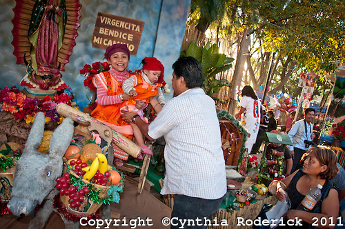
The Royal Ontario Museum in Toronto, Canada, continues to showcase Mexican textiles in a major exhibition entitled Viva México! Clothing and Culture.

The exhibition opened in May this year and closes 23 May 3, 2016. It occupies the museum’s Patricia Harris Gallery of Textiles & Costume. Even though the museum’s collection of Mexican textiles is one of the largest and most important collections of its kind in the world, very few items from the collection have ever been publicly displayed previously.

“Vibrant expressions of creativity, the pieces in this exhibition combine remarkable technical skill with exquisite artistry. Over 150 stunning historic and contemporary pieces are on display, including complete costume ensembles, sarapesrebozos, textiles, embroidery, beadwork and more.”

Rebozo (detail), Ikat-patterned silk, Mexico, 1825-1875. Gift of Mr. and Mrs. W.K. Newcomb.

Rebozo (detail), Ikat-patterned silk, Mexico, 1825-1875. Gift of Mr. and Mrs. W.K. Newcomb.

As the promotional material claims, “The evolution of Mexican fashion reflects the history of Mexico, where the textile arts reach back over many centuries. After the Spanish Conquest of 1521, European styles influenced the distinctive clothing of the Maya, the Aztec and other great civilizations. Contemporary Mexican textiles owe their vitality to the fusion of traditions. ¡Viva Mexico! celebrates this rich and enduring cultural legacy.”

The guest curator for this exhibition is Chloë Sayer, a specialist in Mexican popular art and author of numerous works on the subject, including Costumes of Mexico (1985); Arts and Crafts of Mexico (1990); Mexican Patterns: A Design Source Book (1990); Mexico: The Day of the Dead: An Anthology (1993); Mexican Textile Techniques (1999); Textiles from Mexico (2002); and Fiesta: Days of the Dead & Other Mexican Festivals (2009).

Sayer believes, with good reason, that Mexican textile handcrafts should be named a UNESCO cultural heritage, due to their centuries-old history, and because they are still worn by Mexico’s indigenous peoples. She sees the challenge as being how to ensure that “new generations of Mexicans continue to learn how to make these textiles”

The exhibition comprises about 200 pieces, some dating back to the nineteenth century. “The collection tells the story of Mexican textiles through centuries, and that’s why it’s so valuable,” Sayer said. Sessions when visitors to the exhibition can watch Mexican artists hand-crafting traditional textiles are also scheduled on a regular basis.

There are significant regional differences in the “typical” traditional textiles in Mexico. This exhibition delves into the geography of Mexican textiles and brings long-overdue attention to their extraordinary diversity.

Related posts:

The Trans-Isthmus mega-project

 Mexico's geography in the Press  Comments Off on The Trans-Isthmus mega-project
Jul 272015
 

A huge industrial development plan looks set to get underway shortly in the narrow Isthmus of Tehuantepec in southern Mexico. The low-lying Isthmus of Tehuantepec separates the Chiapas Highlands and the low Yucatán Peninsula from the rest of Mexico. The Isthmus was once considered as an alternative location to Panama for a trans-continental canal.

During Mexico’s internal Reform War (1858‑60), between the liberals, led by Benito Juárez, and the conservatives, both sides encountered serious financial problems. At one point in this war, the liberals accepted an offer from the USA to receive four million pesos in exchange for the USA having the “right of traffic” across the Isthmus of Tehuantepec “in perpetuity”. Fortunately, this treaty was never ratified by the US Senate.

Proyecto-Transistmico

In recent years, the Tehuantepec area has received massive investments in wind power, with several major wind farms already operational and more on the drawing board. The latest plans will build on those investments to provide upgraded infrastructure meeting the preconditions for industrial development.

The 300 million dollars allocated to the first phase of the Trans-Isthmus Project will improve railroads, highways, airports, and the ports of Coatzacoalcos on the Gulf Coast and Salina Cruz on the Pacific Coast (see map).

During the second phase, private sector financing will add industrial development areas, which should boost the area’s contribution to national GDP from 2% to 4.5%, and raise the regional GDP/person to $10,000 a year, close to the national average.

The federal government has designated this region as a special economic zone, offering several fiscal incentives to new enterprises. Chinese investors have already expressed interest in building a 200-million-dollar steel manufacturing plant in the isthmus, utilizing nearby iron ore reserves to produce 3 million tons of steel a year.

Posts related to the same general area of Mexico:

Plan for open-pit gold mine in Baja California Sur rejected

 Books and resources, Mexico's geography in the Press  Comments Off on Plan for open-pit gold mine in Baja California Sur rejected
Oct 122013
 

In November 2012, the federal Environment and Natural Resources Secretariat (Secretaría de Medio Ambiente y Recursos Naturales, Semarnat) refused a request to allow open-pit (opencast) mining in the buffer zone of the Sierra La Laguna Biosphere Reserve in Baja California Sur.

The request came from Zapal SA de CV, whose mining project, currently named “Los Cardones”, is located about 60 km from La Paz, the state capital. The proejct is close to the small settlements of El Triunfo, San Antonio and El Rosario. This mining project was previously called “Paredones Amarillos” and “La Concordia”. The original Concordia project, proposed by US mining firm Vista Gold and Toronto-listed Argonaut, was opposed on environmental and public health grounds by several environmental groups including the Mexican Center for Environmental Law (CEMDA).

Location of Los Cardones mining project. Credit: Tony Burton/Geo-Mexico

Location of Los Cardones mining project.

The latest version, Los Cardones, was resubmitted to authorities in September 2012. The project involved 423 hectares of semi-arid scrub-land, from which Zapal hoped to extract 40 metric tons of gold in the next decade using open-cast (pit) mining. The $217-million project would have created around 2200 jobs.

According to the project’s website (no longer functional), the mining project would have relied entirely on desalinated seawater (brought to the site by a 40-km aqueduct), which would be continuously recycled, and would therefore have no impact on local aquifers. Zapal claimed that the mine would have been the first gold mine in Mexico to use a closed-system cyanidation process, designed to prevent any contamination of the local environment. Zapal is part of the Invecture group which already operates an open cast copper mine in Piedras Verdes, Sonora, claimed to have an impeccable environmental and safety record.

Semarnat rejected the proposal on the grounds that it did not meet the legal requirements for mining operations in a Biosphere Reserve buffer zone. It is likely that a revised application will be made in due course. However, officials of the Baja California state government have previously gone on record as saying that they will oppose any open-cast mining in the state, because of its potential environmental impacts.

Anti-mining protests elsewhere in Mexico

David Bacon, author of “The Right to Stay Home: How US Policy Drives Mexican Migration”, wrote an informed account for the American Program website of several cases across Mexico where opposition to Canadian mining firms has arisen.

  • Mexican Farmers Up Against Canadian Mining Goliaths

A Guardian photo essay entitled “Mexico mining: ‘When injustice is law, resistance is duty’ – in pictures” reported on a January 2013 meeting of some 500 activists from across Mexico and Central America in Capulálpam de Méndez, Oaxaca. The meeting’s slogan was,  “Si la vida! No la
minera!” (Yes to life! No to mining!). It was held to co-ordinate local resistance to the human and environmental costs of mining on the region’s communities.

Related posts:

Apr 212013
 

One of the most curious of Mexico’s dozens of indigenous languages is the whistled language of one group of the Chinantec people who live in the state of Oaxaca. This group’s conventional spoken language is complemented by a language based entirely on whistles. Only a few people remain who speak this whistled language fluently. The language is whistled primarily by men (and much less fluently by children); female members of the group understand it but do not use it.

It is thought that whistled languages developed to enable communication between isolated settlements in areas that were too remote for conventional spoken languages to be effective. The Chinantec’s whistled language has three distinct subsets, designed to be used over different distances. The loudest enables effective communication over a distance of around 200 meters (650 ft).

The Whistled Language of Oaxaca, Mexico

The Chinantec whistled language is now largely confined to the mist- and fog-shrouded slopes of the eastern side of the Sierra Juárez in the northern part of Oaxaca state, a region of high rainfall totals and luxuriant vegetation.

This 27 minute documentary relates the field studies investigating the Chinantec whistling language conducted by Dr. Mark Sicoli, Assistant Professor of Linguistics at Georgetown University. The main center of population of speakers of the whistling language is San Pedro Sochiapam. Sicoli believes that the whistled language may become extinct in the next decade; he hopes that his work documenting the language may one day provide the basis for its reintroduction or restoration.

A transcription of a whistled conversation in Sochiapam Chinantec between two men in different fields was available on the Summer Institute of Linguistics website, which also includes this useful summary of the Chinantec people and language. [at http://www-01.sil.org/mexico/chinanteca/sochiapam/13i-Conversacion-cso.htm in April 2013]

If you only have a few minutes to devote to this video, then look at the section around 16 minutes in, where in a controlled experiment, one experienced Chinantec whistler helps a friend “navigate” through a fictitious village. The men each have a copy of a made-up map of the village, but are out of sight and able to communicate only by whistling.

The astonishing whistled language of the Chinantec is yet another of Mexico’s many cultural wonders that currently appears to be headed for extinction.

Further reading:

Related posts:

Striking photographs of Oaxaca by Cynthia Roderick

 Books and resources  Comments Off on Striking photographs of Oaxaca by Cynthia Roderick
Apr 162013
 

Cynthia Roderick is an award-winning photographer whose work has been widely published in major newspapers, magazines and TV news programs. However, I had not realized until recently that Roderick has a strong affection for Oaxaca. Several portfolios of work related to Oaxaca can be accessed via her website:

  • San Mateo Rio Hondo (40 images) San Mateo Río Hondo, a town and municipality in Oaxaca, is situated in the Miahuatlán District in the south of the Sierra Sur.
Credit: Copyright held by Cynthia Roderick

Credit: Copyright held by Cynthia Roderick

Festival Our Lady of Guadalupe – Image by Cynthia Roderick

Her informal images capture the personalities and sights of these events, warts and all. Roderick has a keen eye for subject matter, color and detail. Her fine photographs bring these events and the magic of Oaxaca to life for her viewers.

Related posts:

The origins of street markets (tianguis) in Oaxaca, Mexico

 Other  Comments Off on The origins of street markets (tianguis) in Oaxaca, Mexico
Oct 152012
 

In an earlier post, we looked at the benefits brought by Mexico’s street markets (tianguis) to both vendors and consumers, and mentioned their long history.

But where, when and why did the first street markets emerge in Mexico?

While there is ample evidence of long-distance trade at least as far back as the Olmec (1500 BC to 200 BC), and we know that there was regular long-distance trade during Aztec times, this trade did not necessarily involve market places and market activity.

Richard Blanton and his co-authors in Ancient Mesoamerica: a comparison of change in three regions offer some insights into how markets may have developed in the Oaxaca region of Mexico.

They point out that relatively little archaeological work has been done on finding the origins of market systems. The major reason for this is because of the paucity of direct archaeological evidence of market activities. Finding “exotic” items (those originating from outside the area) is a clear indication of barter or trade, but does not prove that there was a regular market.There is little or no evidence of the former market stalls and activities for archaeologists to work with.

Ceramic items in a Oaxaca street market. Photo: Tony Burton

Ceramic items in a Oaxaca street market. Photo: Tony Burton

However, several million ceramic pieces found in the Oaxaca area have been collected, and systematically cataloged by complexity of form, and hence, difficulty of manufacture and likely “value”. Blanton and his colleagues explore the idea that the distribution of these ceramics can be used to map ceramic production sites and provide a “faint image of the structure of the region’s marketing system”.

In their words, “Presumably, producers would have  distributed themselves in such a way as to maximize their access to potential customers, and to minimize costs. As the clays needed for ceramic making were available virtually everywhere, potters should have therefore tended to locate themselves close to the marketplace or marketplaces where their goods would be sold, to minimize their costs of moving the pottery.” [p 37]

Echoing central place theory, they write that, “A market system and its specialized producers can’t be supported if the producers can’t make a living. They have to be able to supply a sufficiently large number of households that are willing and able to consume a sufficiently large quantity of their goods.” The “demand threshold” is the minimum demand sufficient for a particular product to be worth producing. People will travel further to purchase a higher cost or rarer item (which has a higher demand threshold), which will be produced in only a single or very small number of locations.

According to Blanton and his colleagues, the data for ceramic types in the Valley of Oaxaca confirm that as early as 500 B.C., only one site contained evidence for the most costly (intricate; many steps involved in production) form of ceramics. This site was located in the center of the valley. On the other hand, a larger number of production sites for less costly ceramics were found, scattered around the valley, each site apparently supplying a small local area. While this is not conclusive proof of regular markets, it is certainly strongly suggestive that this is how markets originated in this region.

More than two thousand years later, the Oaxaca Valley still has some of the most colorful and vibrant markets in Mexico. The map shows the market day for major markets in the area around the city of Oaxaca. For more details, see Markets in and near the city of Oaxaca.

Source:

Blanton, Richard E., Stephen A. Kowalewski, Gary Feinmann and Jill Appel. Ancient Mesoamerica: a comparison of change in three regions. Cambridge University Press, 1981.

Related posts:

The Guelaguetza, the major cultural festival of Oaxaca state

 Other  Comments Off on The Guelaguetza, the major cultural festival of Oaxaca state
Jul 282012
 

Oaxaca’s single biggest cultural event, held in the second half of July, has come to be known as the Guelaguetza, which is Zapotec for “offering” or “mutual help”. It celebrates the cultural and ethnic diversity of the state. This year’s edition (the 80th) of the Guelaguetza ends on Monday 30 July, so this is the final weekend.

A massive open-air amphitheater, seating 100,000 people, is a permanent fixture on the side of the Fortín hill which overlooks the north west quadrant of Oaxaca city. The original Aztec garrison (for the collection of tributes), known as Huaxyacac, was established by Ahuitzotl at the end of the fifteenth century on this very hill. Today, a massive statue of Benito Juárez (cast in Rome in 1891) stares out over the suburbs.

Guelaguetza

The Guelaguetza

The Guelaguetza may have its origins in Mixtec and Zapotec celebrations of their corn crop. Later, the festival was carried on by the Aztecs in honor of their corn god, Xilonen. Later still, in the eighteenth century, the Spanish Carmelite missionaries linked the festival to their own Christian rites for the Virgen del Carmen (16-24 July). The timing holds even more significance today since July 18 also marks the anniversary of the death of Juárez, a much-revered politician of humble, indigenous origin, who served five terms as president of Mexico in the nineteenth century.

Guelaguetza

In the 1930s, the fiesta of the Guelaguetza took on its modern hybrid form, which includes a parade of stilt-walking “giants”. During the Guelaguetza, the Fortín hill is the scene for spectacularly colorful regional folkloric dances performed by several different ethnic groups (Mixtec, Zapotec, Trique, Popolac, Chootal, Chinantec, Mazatec, Mixe) from the seven main geographic regions of the state. The entire city comes alive with color. Color is everywhere from the beautifully hand-embroidered dresses and huipiles, to the food, to the paper streamers decorating the streets and to the mixture of merchandise sold on the sidewalks.

For travelers unable to visit in July, some central hotels, including the Camino Real, luxuriously housed in an architecturally-gorgeous former convent, and the Monte Alban opposite the cathedral, offer a weekly, scaled-down version of the Guelaguetza, year-round.

Want to read more?

Related posts:


Map of Oaxaca state, with an introduction to its geography

 Maps  Comments Off on Map of Oaxaca state, with an introduction to its geography
Mar 122012
 

The state of Oaxaca is Mexico’s fifth largest state, with an area of  93,793 square kilometers (4.8% of the national total) and Mexico’s tenth most populous state, with 3.8 million inhabitants in 2010.

The state has considerable variety in terms of relief, climate and natural vegetation, and has about 570 km of shoreline bordering the Pacific Ocean. Oaxaca City, the centrally located state capital, is an important city for tourism as are three towns on the coast—Puerto Angel, Puerto Escondido and Huatulco.

The eastern part of Oaxaca state is part of the low-lying Isthmus of Tehuantepec, once considered as an alternative location to Panama for a trans-continental canal. In recent years, the Tehuantepec area has received massive investments in wind power, with several major wind farms already operational and more on the drawing board.

Map of Oaxaca state, Mexico. Copyright Tony Burton;

Map of Oaxaca state, Mexico. Copyright Tony Burton; all rights reserved. Click map to enlarge

Oaxaca state state has greater linguistic and cultural diversity than any other state in Mexico. According to the National Commission for the Development of Indigenous Peoples, more than 1.5 million people in Oaxaca live in a home where at least one of the residents either speaks an indigenous language or considers themselves indigenous (even if they do not speak an indigenous language).

About one million inhabitants of Oaxaca, 35% of the state’s total population, speak one or more indigenous language. The largest indigenous linguistic groups in the state include about 350,000 Zapotec, 230,000 Mixtec, 165,000 Mazatec, 100,000 Chinantec, 100,000 Mixe, and 40,000 Chatino.

Related posts:

Build-it-yourself wind and solar power for rural Oaxaca

 Mexico's geography in the Press  Comments Off on Build-it-yourself wind and solar power for rural Oaxaca
Sep 212010
 

Many remote settlements in the mountains of Oaxaca are still not connected to the national electricity grid. A project based in the municipality of Ejutla (60 km south of Oaxaca City) aims to bring affordable renewable energy to isolated hamlets. The innovative scheme relies on a design for a power-producing wind-vane, complemented by a solar panel for when the wind fails to blow.

Wind power in Oaxaca

Wind power in Oaxaca (still from John Dixie's video)

Constructing the system does not require any specialist materials or equipment, but relies on readily available components. For example, the blades for the wind turbine are made of wood which means they are easy to repair and adjust as needed.

More information?

Mexico’s cultural diversity is discussed in chapters 10 and 13 of Geo-Mexico: the geography and dynamics of modern Mexico. Rural areas are the focus of chapter 24 and development indices of various kinds are discussed in chapters 29 and 30. Ask your local library to purchase a copy today!

Markets in and near the city of Oaxaca

 Excerpts from Geo-Mexico  Comments Off on Markets in and near the city of Oaxaca
May 102010
 

The southern state of Oaxaca is famous for its lively and colorful markets. Many villages have a weekly market, and it is possible to travel from one market to the next during a week in Oaxaca without ever visiting the same market twice.

The weekly cycle of markets in and around the city of Oaxaca, Mexico. Map: Tony Burton. All rights reserved.

This is not a coincidence, since it is precisely what many of the market vendors do every week in order to maximize the number of people exposed to their salesmanship and wares. This is related to an important concept in central place theory, that of the threshold population required to support a particular good or service.

Visiting even a single weekly market in Oaxaca is a fascinating way of experiencing first-hand some of the amazing cultural diversity of this  extraordinary state.

Click here for an interactive version of the map of markets in central Oaxaca. The geography of Mexico’s markets is discussed in chapter 24 of Geo-Mexico: the geography and dynamics of modern Mexico

Related article:

Oaxaca is the most culturally diverse state in Mexico